
| DANIEL FIELD AUGUSTA GA |
| |
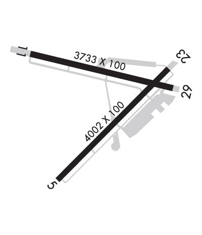
| Lat: N 3328.0 Long: W 08202.4 Elev: 422 Var: +04 Longest Runway: 4002 | ||
| Clr Del: 122.3 RCO AWOS: 135.27 CTAF: 123.05 | ||
| ||||||||||||||||||||||||||||||||||||||||||||
| ||||||||||||||||||||||||||||||||||||||||||||
| ||||||||||||||||||||||||||||||||||||||||||||
| Rwy | Rwy | |||||||
| 4002x100 | 3800' | 4002x100 | 3704' | |||||
| 3733x100 | 3407' | 3733x100 | 3419' | |||||
| Runway ID | Single Wheel | Double Wheel | Double Tandem Wheel | Dual Double Wheel |
| 05/23 | 30,000 | N/A | N/A | N/A |
| 11/29 | 30,000 | N/A | N/A | N/A |
| These numbers are Advisory and are not limits. The Airport Manager should have more accurate Weight Limits | ||||
 Airport Diagram might not be current. | |
| Facility Name: | DANIEL FLD |
| City Name: | AUGUSTA |
| County: | RICHMOND |
| State abbrev: | GA |
| State Name: | GEORGIA |
| Ownership: | PUBLICLY OWNED |
| Use: | OPEN TO THE PUBLIC |
| Owner's Name: | AUGUSTA-RICHMOND CO |
| Address: | 535 TELFAIR STREET |
| AUGUSTA, GA 30901 | |
| Owner's Phone: | (706) 821-2300 |
| Manager's Name: | STEVE GAY, PRES |
| Address: | AUGUSTA AVIATION (FBO), 1775 HIGHLAND AVE |
| AUGUSTA, GA 30904 | |
| Phone: | 706-733-8970 |
| FAA Region: | SOUTHERN |
| FAA Field Office: | ATL |
| Date | Sunrise | Sunset |
|---|---|---|
| 06/08/26 Monday | 6:18 | 20:37 |
| 06/09/26 Tuesday | 6:18 | 20:37 |
| 06/10/26 Wednesday | 6:18 | 20:37 |
| 06/11/26 Thursday | 6:18 | 20:38 |
| 06/12/26 Friday | 6:18 | 20:38 |
| 06/13/26 Saturday | 6:18 | 20:39 |
| 06/14/26 Sunday | 6:18 | 20:39 |
| 06/15/26 Monday | 6:18 | 20:39 |
| 06/16/26 Tuesday | 6:18 | 20:40 |
| 06/17/26 Wednesday | 6:18 | 20:40 |
| 06/18/26 Thursday | 6:18 | 20:40 |
| 06/19/26 Friday | 6:18 | 20:41 |
| 06/20/26 Saturday | 6:18 | 20:41 |
| 06/21/26 Sunday | 6:19 | 20:41 |
| Airport Attendance Schedule | 7 Days A Week 0700-DUSK |
| Airport Status | OPERATIONAL (This Status can change at any time - please check NOTAMS) |
| Airport Lighting Schedule | ACTVT REIL RWY 05, 11, 23; PAPI RWY 05, 11, & 23; MIRL RWY 05/23 & 11/29 - CTAF. |
| Airport Storage Available | Tie Downs, Hanger |
| Extra Services Available | Air Ambulance, Avionics, Charter, Flight Instruction, Aircraft Rental, Aircraft Sales |
| Wind Indicator | YES - (lighted) |
| Control Tower | NO |
| CTAF Frequency | 123.050 |
| Unicom Frequency | 123.050 |
| Rotating Beacon Color | WG |
| Segmented Circle | NO |
| Landing Fee | NO |
| Airport Inspected | STATE - performed by STATE AERONAUTICAL PERSONNEL |
| Inspection Date | 04/02/2026 |
| Type of Fuel Available | Grade 100LL, JET A-1 (icing inhibitor, freeze point -50C) |
| Airframe Repair Service | MAJOR |
| Power Plant Repair Service | MAJOR |
| Latitude | N3328.0 |
| Longitude | W08202.4 (ESTIMATED) |
| Arpt Elevation | 422ft (SURVEYED) |
| Magnetic Variation | 04W |
| 1 miles W | of AUGUSTA |
| Traffic Pattern Altitude | |
| Sectional Chart | ATLANTA |
| Operations (Reported) | Yearly | Avg. Daily |
|---|---|---|
| General Aviation Transient | 0 | 0 |
| General Aviation Local | 0 | 0 |
| Air Taxi | 0 | 0 |
| Commerical | 0 | 0 |
| Commuter | 0 | 0 |
| Military | 0 | 0 |
| Aircraft based on Field | |
|---|---|
| General Aviation Singles | 0 |
| General Aviation Multi | 0 |
| Jet Aircraft | 0 |
| General Aviation Helicopters | 0 |
| Military Aircraft | 0 |
| Gliders | 0 |
| Ultralights | 0 |
| FSS on field | NO |
| FSS tie-in | MACON |
| FSS Phone | 1-800-WX-BRIEF |
| Who issues Notams | DNL |
| Notam D service at airport | YES |
| ARTCC Name | ATLANTA |
| Airport Certification | |
| Aircraft Rescue & Firefighting Index | None |
| Airport of Entry | No |
| Custom Landing Rights | No |
| Joint Civil/Military | No |
| Military Landing rights | YES |
| NATIONAL PLAN OF INTEGRATED AIRPORT SYSTEMS (NPIAS) |
| GRANT AGREEMENTS UNDER FAAP/ADAP/AIP |
| SURPLUS PROPERTY AGREEMENT UNDER PUBLIC LAW 289 |
| ASSURANCES PURSUANT TO TITLE VI, CIVIL RIGHTS ACT OF 1964 |
| AGREEMENT UNDER DLAND OR DCLA HAS EXPIRED. |
| PILOTS SHOULD BE ALERT FOR TURBO-JET TFC TRANSITING THE TFC AREA ENR TO BUSH FLD 6 MILES SOUTH. |
Airport Communications & Frequencies:
| |||||||||||||||||
| Runway: 05 | Runway: 23 | ||
| Mag heading: | 50° | Mag heading: | 230° |
| Rwy Slope: | 1.21% Up | Rwy Slope: | -1.21% Down |
| Approach: | Approach: | ||
| Pattern: | Left Traffic | Pattern: | Left Traffic |
| Markings: | NONPRECISION INSTRUMENT | Markings: | NONPRECISION INSTRUMENT |
| Marking Condition: | GOOD | Marking Condition: | GOOD |
| Arresting Dev: | Arresting Dev: | ||
| Lat & Long: | N3327.7 W08202.6 | Lat. & Long.: | N3328.1 W08202.1 |
| Elev: | 373.9 ft. MSL | Elev: | 422.3 ft. MSL |
| TCH: | 30 ft. AGL | TCH: | 26 ft. AGL |
| Visual Glide Path: | 3.00 degrees | Visual Glide Path: | 3.30 degrees |
| Displaced Threshold: | 202 feet | Displaced Threshold: | 298 feet |
| Touchdown Zone: | YES | Touchdown Zone: | YES |
| Touchdown Elev.: | 410.9 feet | Touchdown Elev.: | 422.3 feet |
| Visual Glide Slope: | 2-Light PAPI on LEFT side of Runway | Visual Glide Slope: | 2-Light PAPI on LEFT side of Runway |
| RVR Equipment: | RVR Equipment: | ||
| RVV Equipment: | NO | RVV Equipment: | NO |
| Approach Lights: | Approach Lights: | ||
| REIL: | YES | REIL: | YES |
| Centerline Lights: | NO | Centerline Lights: | NO |
| Touchdown lights: | NO | Touchdown lights: | NO |
| Runway Category: | D | Runway Category: | Runway with a Visual Approach |
| Declared Distances: | Declared Distances: | ||
| Obstructions: | TREE | Obstructions: | ROAD |
| Marked: | NOT Marked/Lighted | Marked: | NOT Marked/Lighted |
| Clearance slope: | 8:1; APCH RATIO 50:1 TO DSPLCD THLD. | Clearance slope: | APCH RATIO 16:1 TO DSPLCD THLD; 34FT LIGHT POLE, 577 FT FROM THLD, 213 FT RIGHT. |
| Obstruction height: | 10 feet AGL | Obstruction height: | 15 feet AGL |
| Dist. from runway: | 280 feet | Dist. from runway: | 201 feet |
| Centerline offset: | 243 right of centerline | Centerline offset: | 80 feet right of centerline |
| Comments: | Comments: | 6 FT FENCE 190 FT FM THLD 125 FT RIGHT. |
| Runway: 11 | Runway: 29 | ||
| Mag heading: | 108° | Mag heading: | 288° |
| Rwy Slope: | -.07% Down | Rwy Slope: | .07% Up |
| Approach: | Approach: | ||
| Pattern: | Left Traffic | Pattern: | Left Traffic |
| Markings: | NONPRECISION INSTRUMENT | Markings: | NONPRECISION INSTRUMENT |
| Marking Condition: | GOOD | Marking Condition: | GOOD |
| Arresting Dev: | Arresting Dev: | ||
| Lat & Long: | N3328.2 W08202.8 | Lat. & Long.: | N3328.0 W08202.0 |
| Elev: | 421.4 ft. MSL | Elev: | 418.7 ft. MSL |
| TCH: | 54 ft. AGL | TCH: | |
| Visual Glide Path: | 3.50 degrees | Visual Glide Path: | |
| Displaced Threshold: | 326 feet | Displaced Threshold: | 314 feet |
| Touchdown Zone: | YES | Touchdown Zone: | YES |
| Touchdown Elev.: | 421.6 feet | Touchdown Elev.: | 421.6 feet |
| Visual Glide Slope: | 4-Light PAPI on LEFT side of Runway; RWY 11 PAPI UNUSBL BYD 3 DEG LEFT OF RWY CNTRLN, PAPI IS BAFFLED. | Visual Glide Slope: | |
| RVR Equipment: | RVR Equipment: | ||
| RVV Equipment: | NO | RVV Equipment: | NO |
| Approach Lights: | Approach Lights: | ||
| REIL: | YES | REIL: | NO |
| Centerline Lights: | NO | Centerline Lights: | NO |
| Touchdown lights: | NO | Touchdown lights: | NO |
| Runway Category: | Runway with a Non-precision Approach | Runway Category: | Runway with a Visual Approach |
| Declared Distances: | TORA:3733' TODA:3733' ASDA:3733' LDA:3407' | Declared Distances: | TORA:3733' TODA:3733' ASDA:3733' LDA:3419' |
| Obstructions: | ROAD | Obstructions: | ROAD |
| Marked: | LIGHTED | Marked: | NOT Marked/Lighted |
| Clearance slope: | APCH RATIO 0:1 TO DSPLCD THLD; 20 FT ROAD/FENCE AT DSPLCD THLD & 245 FT LEFT. | Clearance slope: | APCH RATIO 13:1 TO DSPLCD THLD; +55 FT TREES 715 FT FROM THLD, 139 FT LEFT. |
| Obstruction height: | 25 feet AGL | Obstruction height: | 15 feet AGL |
| Dist. from runway: | 201 feet | Dist. from runway: | 201 feet |
| Centerline offset: | 145 left of centerline | Centerline offset: | 180 feet left of centerline |
| Comments: | 6 FT FENCE 190 FT FM THLD 94 FT RIGHT. | Comments: |
Thanks for using FltPlan.com
all rights reserved © 1999-2026 by Flight Plan LLC
