| DEMING MUNI DEMING NM |
| |
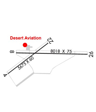
| Lat: N 3215.7 Long: W 10743.1 Elev: 4314 Var: -10 Longest Runway: 8018 | ||
| AWOS: 118.52 CTAF: 122.8 | ||
| |||||||||||||||||||||||
| |||||||||||||||||||||||
| |||||||||||||||||||||||
| Rwy | Rwy | |||||||
| 5675x60 | 5675' | 5675x60 | 5675' | |||||
| 8018x75 | 8018' | 8018x75 | 8018' | |||||
| Runway ID | Single Wheel | Double Wheel | Double Tandem Wheel | Dual Double Wheel |
| 04/22 | 12,000 | N/A | N/A | N/A |
| 08/26 | 20,000 | N/A | N/A | N/A |
| These numbers are Advisory and are not limits. The Airport Manager should have more accurate Weight Limits | ||||
 Airport Diagram might not be current. | |
| Facility Name: | DEMING MUNI |
| City Name: | DEMING |
| County: | LUNA |
| State abbrev: | NM |
| State Name: | NEW MEXICO |
| Ownership: | PUBLICLY OWNED |
| Use: | OPEN TO THE PUBLIC |
| Owner's Name: | CITY OF DEMING |
| Address: | PO BOX 706 |
| DEMING, NM 88031 | |
| Owner's Phone: | 575-546-8848 |
| Manager's Name: | ALEXI JACKSON |
| Address: | PO BOX 706 |
| DEMING, NM 88031 | |
| Phone: | 575-544-3660 |
| FAA Region: | SOUTHWEST |
| FAA Field Office: | LNM |
| Date | Sunrise | Sunset |
|---|---|---|
| 09/24/21 Friday | 7:00 | 19:05 |
| 09/25/21 Saturday | 7:01 | 19:04 |
| 09/26/21 Sunday | 7:01 | 19:02 |
| 09/27/21 Monday | 7:02 | 19:01 |
| 09/28/21 Tuesday | 7:03 | 19:00 |
| 09/29/21 Wednesday | 7:03 | 18:58 |
| 09/30/21 Thursday | 7:04 | 18:57 |
| 10/01/21 Friday | 7:05 | 18:56 |
| 10/02/21 Saturday | 7:05 | 18:55 |
| 10/03/21 Sunday | 7:06 | 18:53 |
| 10/04/21 Monday | 7:07 | 18:52 |
| 10/05/21 Tuesday | 7:07 | 18:51 |
| 10/06/21 Wednesday | 7:08 | 18:49 |
| 10/07/21 Thursday | 7:09 | 18:48 |
| Airport Attendance Schedule | 7 Days A Week 0700-1800; FOR ARPT ATTENDANT AFT HRS CALL 575-494-2311. |
| Airport Status | OPERATIONAL (This Status can change at any time - please check NOTAMS) |
| Airport Lighting Schedule | MIRL RY 08/26 & PAPI RYS 08 & 26 PRESET LOW INTST 1730-2230; TO INCR INTST ACTVT - CTAF. |
| Airport Storage Available | Tie Downs, Hanger |
| Extra Services Available | Air Ambulance |
| Wind Indicator | YES - (lighted) |
| Control Tower | NO |
| CTAF Frequency | 122.800 |
| Unicom Frequency | 122.800 |
| Rotating Beacon Color | CLEAR-GREEN (Light Land Airport) |
| Segmented Circle | NO |
| Landing Fee | NO |
| Airport Inspected | STATE - performed by PRIVATE CONTRACT PERSONNEL |
| Inspection Date | 03/24/2020 |
| Type of Fuel Available | Grade 100LL, JET A-1 (icing inhibitor, freeze point -50C) |
| Airframe Repair Service | MAJOR |
| Power Plant Repair Service | MAJOR |
| Latitude | N3215.7 |
| Longitude | W10743.1 (ESTIMATED) |
| Arpt Elevation | 4314ft (SURVEYED) |
| Magnetic Variation | 10E |
| 2 miles SE | of DEMING |
| Traffic Pattern Altitude | |
| Sectional Chart | ALBUQUERQUE |
| Operations (Reported) | Yearly | Avg. Daily |
|---|---|---|
| General Aviation Transient | 12000 | 33 |
| General Aviation Local | 6570 | 18 |
| Air Taxi | 960 | 3 |
| Commerical | 0 | 0 |
| Commuter | 0 | 0 |
| Military | 9125 | 25 |
| Aircraft based on Field | |
|---|---|
| General Aviation Singles | 7 |
| General Aviation Multi | 3 |
| Jet Aircraft | 1 |
| General Aviation Helicopters | 0 |
| Military Aircraft | 0 |
| Gliders | 0 |
| Ultralights | 0 |
| FSS on field | NO |
| FSS tie-in | ALBUQUERQUE |
| FSS Phone | 1-800-WX-BRIEF |
| Who issues Notams | DMN |
| Notam D service at airport | YES |
| ARTCC Name | ALBUQUERQUE |
| Airport Certification | |
| Aircraft Rescue & Firefighting Index | None |
| Airport of Entry | No |
| Custom Landing Rights | No |
| Joint Civil/Military | No |
| Military Landing rights | YES |
| NATIONAL PLAN OF INTEGRATED AIRPORT SYSTEMS (NPIAS) |
| GRANT AGREEMENTS UNDER FAAP/ADAP/AIP |
| SURPLUS PROPERTY AGREEMENT UNDER PUBLIC LAW 289 |
| ASSURANCES PURSUANT TO TITLE VI, CIVIL RIGHTS ACT OF 1964 |
| HELICOPTERS ARR FM EAST & DEP TO EAST REMAIN NORTH OF SEGMENTED CIRCLE. |
| NO INTERSECTION TKOFS. |
| FOR CD IF UNA TO CTC ON FSS FREQ, CTC ALBUQUERQUE ARTCC AT 505-856-4561. |
| EMERG ACFT AND POWERPLANT REPAIR AVBL CALL 575-544-3660. |
Airport Communications & Frequencies:
| |||||||||
| Runway: 04 | Runway: 22 | ||
| Mag heading: | 42° | Mag heading: | 222° |
| Rwy Slope: | -.14% Down | Rwy Slope: | .14% Up |
| Approach: | Approach: | ||
| Pattern: | Left Traffic | Pattern: | Left Traffic |
| Markings: | NONPRECISION INSTRUMENT | Markings: | BASIC |
| Marking Condition: | GOOD | Marking Condition: | GOOD |
| Arresting Dev: | Arresting Dev: | ||
| Lat & Long: | N3215.4 W10743.9 | Lat. & Long.: | N3216.0 W10743.0 |
| Elev: | 4310.7 ft. MSL | Elev: | 4302.8 ft. MSL |
| TCH: | 44 ft. AGL | TCH: | 44 ft. AGL |
| Visual Glide Path: | 3.00 degrees | Visual Glide Path: | 3.00 degrees |
| Displaced Threshold: | No | Displaced Threshold: | No |
| Touchdown Zone: | YES | Touchdown Zone: | YES |
| Touchdown Elev.: | 4311.6 feet | Touchdown Elev.: | 4310.4 feet |
| Visual Glide Slope: | 2-Light PAPI on LEFT side of Runway | Visual Glide Slope: | 2-Light PAPI on LEFT side of Runway |
| RVR Equipment: | RVR Equipment: | ||
| RVV Equipment: | NO | RVV Equipment: | NO |
| Approach Lights: | Approach Lights: | ||
| REIL: | NO | REIL: | NO |
| Centerline Lights: | NO | Centerline Lights: | NO |
| Touchdown lights: | NO | Touchdown lights: | NO |
| Runway Category: | Runway with a Non-precision Approach | Runway Category: | Runway with a Visual Approach |
| Declared Distances: | Declared Distances: | ||
| Obstructions: | Obstructions: | BRUSH | |
| Marked: | Marked: | NOT Marked/Lighted | |
| Clearance slope: | 20:1 | Clearance slope: | 1:1 |
| Obstruction height: | Obstruction height: | 6 feet AGL | |
| Dist. from runway: | Dist. from runway: | 210 feet | |
| Centerline offset: | Centerline offset: | 75 feet right of centerline | |
| Comments: | +5 FT BRUSH 190 FT FM THLD 60 FT LEFT OF CENTERLINE. | Comments: | +3-8 FT BRUSH 60-200 FT FM THLD 75 FT RIGHT & 75 FT LEFT OF CNTRLN. |
| Runway: 08 | Runway: 26 | ||
| Mag heading: | 80° | Mag heading: | 260° |
| Rwy Slope: | -.32% Down | Rwy Slope: | .32% Up |
| Approach: | Approach: | ||
| Pattern: | Left Traffic | Pattern: | Left Traffic |
| Markings: | NONPRECISION INSTRUMENT | Markings: | NONPRECISION INSTRUMENT |
| Marking Condition: | GOOD | Marking Condition: | FAIR |
| Arresting Dev: | Arresting Dev: | ||
| Lat & Long: | N3215.8 W10743.7 | Lat. & Long.: | N3215.8 W10742.1 |
| Elev: | 4314.0 ft. MSL | Elev: | 4288.5 ft. MSL |
| TCH: | 43 ft. AGL | TCH: | 40 ft. AGL |
| Visual Glide Path: | 3.00 degrees | Visual Glide Path: | 3.00 degrees |
| Displaced Threshold: | No | Displaced Threshold: | No |
| Touchdown Zone: | YES | Touchdown Zone: | YES |
| Touchdown Elev.: | 4314.0 feet | Touchdown Elev.: | 4297.4 feet |
| Visual Glide Slope: | 4-Light PAPI on LEFT side of Runway | Visual Glide Slope: | 4-Light PAPI on LEFT side of Runway |
| RVR Equipment: | RVR Equipment: | ||
| RVV Equipment: | NO | RVV Equipment: | NO |
| Approach Lights: | Approach Lights: | ||
| REIL: | NO | REIL: | NO |
| Centerline Lights: | NO | Centerline Lights: | NO |
| Touchdown lights: | NO | Touchdown lights: | NO |
| Runway Category: | Runway with a Non-precision Approach having visibility minimums greater than 3/4 mile | Runway Category: | Runway with a Non-precision Approach having visibility minimums greater than 3/4 mile |
| Declared Distances: | Declared Distances: | ||
| Obstructions: | BRUSH | Obstructions: | |
| Marked: | NOT Marked/Lighted | Marked: | |
| Clearance slope: | 17:1 | Clearance slope: | 50:1 |
| Obstruction height: | 4 feet AGL | Obstruction height: | |
| Dist. from runway: | 270 feet | Dist. from runway: | |
| Centerline offset: | 75 right of centerline | Centerline offset: | |
| Comments: | Comments: |
Thanks for using FltPlan.com
all rights reserved © 1999-2021 by Flight Plan LLC