
| DELAWARE MUNI DELAWARE OH |
| |
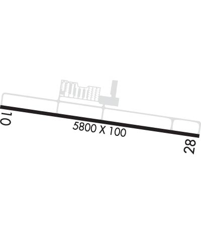
| Lat: N 4016.8 Long: W 08306.8 Elev: 945 Var: +06 Longest Runway: 5800 | ||
| AWOS: 119.02 CTAF: 122.7 | ||
| ||||||||||||||||||||||||||||||||||||||||||||
| ||||||||||||||||||||||||||||||||||||||||||||
| ||||||||||||||||||||||||||||||||||||||||||||
| Rwy | Rwy | |||||||
| 5800x100 | 5800' | 5800x100 | 5800' | |||||
| Runway ID | Single Wheel | Double Wheel | Double Tandem Wheel | Dual Double Wheel |
| 10/28 | 100,000 | 139,000 | 233,000 | N/A |
| These numbers are Advisory and are not limits. The Airport Manager should have more accurate Weight Limits | ||||
 Airport Diagram might not be current. | |
| Facility Name: | DELAWARE MUNI/JIM MOORE FLD |
| City Name: | DELAWARE |
| County: | DELAWARE |
| State abbrev: | OH |
| State Name: | OHIO |
| Ownership: | PUBLICLY OWNED |
| Use: | OPEN TO THE PUBLIC |
| Owner's Name: | CITY OF DELAWARE |
| Address: | 1 S SANDUSKY ST |
| DELAWARE, OH 43015-2326 | |
| Owner's Phone: | 740-203-1800 |
| Manager's Name: | KEVIN PIATT |
| Address: | 1075 PITTSBURGH DR |
| DELAWARE, OH 43015-3848 | |
| Phone: | 740-203-1870; AFT HRS 740-203-1870, OPTION 9. |
| FAA Region: | GREAT LAKES |
| FAA Field Office: | DET |

| Date | Sunrise | Sunset |
|---|---|---|
| 06/12/26 Friday | 6:02 | 21:03 |
| 06/13/26 Saturday | 6:02 | 21:03 |
| 06/14/26 Sunday | 6:02 | 21:03 |
| 06/15/26 Monday | 6:02 | 21:04 |
| 06/16/26 Tuesday | 6:02 | 21:04 |
| 06/17/26 Wednesday | 6:02 | 21:05 |
| 06/18/26 Thursday | 6:02 | 21:05 |
| 06/19/26 Friday | 6:02 | 21:05 |
| 06/20/26 Saturday | 6:03 | 21:05 |
| 06/21/26 Sunday | 6:03 | 21:06 |
| 06/22/26 Monday | 6:03 | 21:06 |
| 06/23/26 Tuesday | 6:03 | 21:06 |
| 06/24/26 Wednesday | 6:04 | 21:06 |
| 06/25/26 Thursday | 6:04 | 21:06 |
| Airport Attendance Schedule | 7 Days A Week 0800-1700; CLSD THANKSGIVING, CHRISTMAS, & NEW YEARS. |
| Airport Status | OPERATIONAL (This Status can change at any time - please check NOTAMS) |
| Airport Lighting Schedule | ACTVT REIL RWY 10 & 28; PAPI RWY 10 & 28; MIRL RWY 10/28 - CTAF. |
| Airport Storage Available | Tie Downs, Hanger |
| Extra Services Available | Flight Instruction, Aircraft Rental |
| Wind Indicator | YES - (lighted) |
| Control Tower | NO |
| CTAF Frequency | 122.700 |
| Unicom Frequency | 122.700 |
| Rotating Beacon Color | WG |
| Segmented Circle | NO |
| Landing Fee | NO |
| Airport Inspected | STATE - performed by STATE AERONAUTICAL PERSONNEL |
| Inspection Date | 09/29/2023 |
| Type of Fuel Available | Grade 100LL, JET A (freeze point -40C), JET A |
| Airframe Repair Service | MAJOR |
| Power Plant Repair Service | MAJOR |
| Latitude | N4016.8 |
| Longitude | W08306.8 (ESTIMATED) |
| Arpt Elevation | 945ft (SURVEYED) |
| Magnetic Variation | 06W |
| 3 miles SW | of DELAWARE |
| Traffic Pattern Altitude | |
| Sectional Chart | DETROIT |
| Operations (Reported) | Yearly | Avg. Daily |
|---|---|---|
| General Aviation Transient | 0 | 0 |
| General Aviation Local | 0 | 0 |
| Air Taxi | 0 | 0 |
| Commerical | 0 | 0 |
| Commuter | 0 | 0 |
| Military | 0 | 0 |
| Aircraft based on Field | |
|---|---|
| General Aviation Singles | 0 |
| General Aviation Multi | 0 |
| Jet Aircraft | 0 |
| General Aviation Helicopters | 0 |
| Military Aircraft | 0 |
| Gliders | 0 |
| Ultralights | 0 |
| FSS on field | NO |
| FSS tie-in | DAYTON |
| FSS Phone | 1-800-WX-BRIEF |
| Who issues Notams | DLZ |
| Notam D service at airport | YES |
| ARTCC Name | INDIANAPOLIS |
| Airport Certification | |
| Aircraft Rescue & Firefighting Index | None |
| Airport of Entry | No |
| Custom Landing Rights | No |
| Joint Civil/Military | No |
| Military Landing rights | No |
| NATIONAL PLAN OF INTEGRATED AIRPORT SYSTEMS (NPIAS) |
| GRANT AGREEMENTS UNDER FAAP/ADAP/AIP |
| ASSURANCES PURSUANT TO TITLE VI, CIVIL RIGHTS ACT OF 1964 |
| OCNL DEER & OTR WILDLIFE ON & INVOF ARPT. |
| INTMT NGT ACT AT QUARRY OFF WEST END OF RWY 10. |
| ULTRALIGHT TFC RMN S OF RWY AT 400 FT AGL. |
| FOR CD CTC COLUMBUS APCH AT 614-338-8537. |
| RWY 28 CALM WIND RWY. |
Airport Communications & Frequencies:
| ||||||||||||||
| Runway: 10 | Runway: 28 | ||
| Mag heading: | 104° | Mag heading: | 284° |
| Rwy Slope: | .01% Up | Rwy Slope: | -.01% Down |
| Approach: | Approach: | ||
| Pattern: | Left Traffic | Pattern: | Left Traffic |
| Markings: | NONPRECISION INSTRUMENT | Markings: | NONPRECISION INSTRUMENT |
| Marking Condition: | GOOD | Marking Condition: | GOOD |
| Arresting Dev: | Arresting Dev: | ||
| Lat & Long: | N4016.8 W08307.4 | Lat. & Long.: | N4016.7 W08306.2 |
| Elev: | 944.2 ft. MSL | Elev: | 944.7 ft. MSL |
| TCH: | 43 ft. AGL | TCH: | 41 ft. AGL |
| Visual Glide Path: | 3.00 degrees | Visual Glide Path: | 3.00 degrees |
| Displaced Threshold: | No | Displaced Threshold: | No |
| Touchdown Zone: | YES | Touchdown Zone: | YES |
| Touchdown Elev.: | 945.1 feet | Touchdown Elev.: | 944.8 feet |
| Visual Glide Slope: | 4-Light PAPI on LEFT side of Runway | Visual Glide Slope: | 4-Light PAPI on LEFT side of Runway; PAPI UNUSBL BYD 8 DEGS RIGHT OF CNTRLN. |
| RVR Equipment: | RVR Equipment: | ||
| RVV Equipment: | NO | RVV Equipment: | NO |
| Approach Lights: | Approach Lights: | ||
| REIL: | YES | REIL: | YES |
| Centerline Lights: | NO | Centerline Lights: | NO |
| Touchdown lights: | NO | Touchdown lights: | NO |
| Runway Category: | Runway with a Non-precision Approach having visibility minimums greater than 3/4 mile | Runway Category: | Runway with a Non-precision Approach having visibility minimums greater than 3/4 mile |
| Declared Distances: | Declared Distances: | ||
| Obstructions: | HILL | Obstructions: | TREES |
| Marked: | NOT Marked/Lighted | Marked: | NOT Marked/Lighted |
| Clearance slope: | 19:1 | Clearance slope: | 17:1 |
| Obstruction height: | 144 feet AGL | Obstruction height: | 75 feet AGL |
| Dist. from runway: | 3061 feet | Dist. from runway: | 1476 feet |
| Centerline offset: | 314 right of centerline | Centerline offset: | 230 feet left of centerline |
| Comments: | Comments: |
Thanks for using FltPlan.com
all rights reserved © 1999-2026 by Flight Plan LLC