| DILLON DILLON MT |
| |
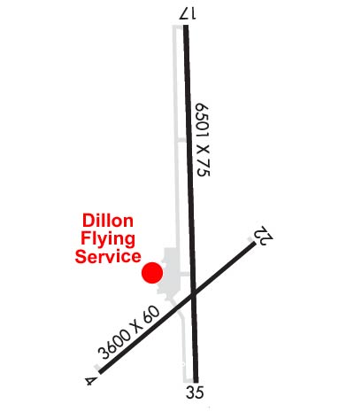
| Lat: N 4515.3 Long: W 11233.2 Elev: 5245 Var: -13 Longest Runway: 6501 | ||
| AWOS: 135.22 CTAF: 122.8 | ||
| |||||||||||||||||||||||||||||||||||||||||||||||||||||||||||||
| |||||||||||||||||||||||||||||||||||||||||||||||||||||||||||||
| |||||||||||||||||||||||||||||||||||||||||||||||||||||||||||||
| Rwy | Rwy | |||||||
| 3600x60 | 3600' | 3600x60 | 3600' | |||||
| 6501x75 | 6501' | 6501x75 | 6501' | |||||
| Runway ID | Single Wheel | Double Wheel | Double Tandem Wheel | Dual Double Wheel |
| 04/22 | 12,500 | N/A | N/A | N/A |
| 17/35 | 58,000 | 106,000 | 129,000 | N/A |
| These numbers are Advisory and are not limits. The Airport Manager should have more accurate Weight Limits | ||||
 Airport Diagram might not be current. | |
| Facility Name: | DILLON |
| City Name: | DILLON |
| County: | BEAVERHEAD |
| State abbrev: | MT |
| State Name: | MONTANA |
| Ownership: | PUBLICLY OWNED |
| Use: | OPEN TO THE PUBLIC |
| Owner's Name: | BEAVERHEAD COUNTY |
| Address: | 2 S. PACIFIC ST |
| DILLON, MT 59725-2799 | |
| Owner's Phone: | 406-683-5242 |
| Manager's Name: | JOSIAH JONES |
| Address: | 2400 AIRPORT ROAD |
| DILLON, MT 59725 | |
| Phone: | 406-660-1873 |
| FAA Region: | NORTHWEST MOUNTAIN |
| FAA Field Office: | HLN |
| Date | Sunrise | Sunset |
|---|---|---|
| 06/08/26 Monday | 5:43 | 21:16 |
| 06/09/26 Tuesday | 5:43 | 21:17 |
| 06/10/26 Wednesday | 5:42 | 21:17 |
| 06/11/26 Thursday | 5:42 | 21:18 |
| 06/12/26 Friday | 5:42 | 21:18 |
| 06/13/26 Saturday | 5:42 | 21:19 |
| 06/14/26 Sunday | 5:42 | 21:19 |
| 06/15/26 Monday | 5:42 | 21:20 |
| 06/16/26 Tuesday | 5:42 | 21:20 |
| 06/17/26 Wednesday | 5:42 | 21:20 |
| 06/18/26 Thursday | 5:42 | 21:21 |
| 06/19/26 Friday | 5:42 | 21:21 |
| 06/20/26 Saturday | 5:42 | 21:21 |
| 06/21/26 Sunday | 5:42 | 21:22 |
| Airport Attendance Schedule | 7 Days A Week 0800-1700; AFT HR - AMGR OR 406-250-5280. |
| Airport Status | OPERATIONAL (This Status can change at any time - please check NOTAMS) |
| Airport Lighting Schedule | ACTVT PAPI RWY 17, 22, & 35; MIRL RWY 04/22 & 17/35 - CTAF. |
| Airport Storage Available | Tie Downs, Hanger |
| Extra Services Available | NONE |
| Wind Indicator | YES - (lighted) |
| Control Tower | NO |
| CTAF Frequency | 122.800 |
| Unicom Frequency | 122.800 |
| Rotating Beacon Color | WG |
| Segmented Circle | YES |
| Landing Fee | YES |
| Airport Inspected | STATE - performed by STATE AERONAUTICAL PERSONNEL |
| Inspection Date | 04/10/2026 |
| Type of Fuel Available | Grade 100LL, JET A (freeze point -40C), JET A |
| Airframe Repair Service | NONE |
| Power Plant Repair Service | NONE |
| Latitude | N4515.3 |
| Longitude | W11233.2 (ESTIMATED) |
| Arpt Elevation | 5244ft (SURVEYED) |
| Magnetic Variation | 13E |
| 4 miles NE | of DILLON |
| Traffic Pattern Altitude | |
| Sectional Chart | GREAT FALLS |
| Operations (Reported) | Yearly | Avg. Daily |
|---|---|---|
| General Aviation Transient | 0 | 0 |
| General Aviation Local | 0 | 0 |
| Air Taxi | 0 | 0 |
| Commerical | 0 | 0 |
| Commuter | 0 | 0 |
| Military | 0 | 0 |
| Aircraft based on Field | |
|---|---|
| General Aviation Singles | 0 |
| General Aviation Multi | 0 |
| Jet Aircraft | 0 |
| General Aviation Helicopters | 0 |
| Military Aircraft | 0 |
| Gliders | 0 |
| Ultralights | 0 |
| FSS on field | NO |
| FSS tie-in | GREAT FALLS |
| FSS Phone | 1-800-WX-BRIEF |
| Who issues Notams | DLN |
| Notam D service at airport | YES |
| ARTCC Name | SALT LAKE CITY |
| Airport Certification | |
| Aircraft Rescue & Firefighting Index | None |
| Airport of Entry | No |
| Custom Landing Rights | No |
| Joint Civil/Military | No |
| Military Landing rights | YES |
| NATIONAL PLAN OF INTEGRATED AIRPORT SYSTEMS (NPIAS) |
| GRANT AGREEMENTS UNDER FAAP/ADAP/AIP |
| ASSURANCES PURSUANT TO TITLE VI, CIVIL RIGHTS ACT OF 1964 |
| FOR CD IF UNA TO CTC ON FSS FREQ, CTC SALT LAKE ARTCC AT 801-320-2568. |
| RWY VIS BLOCKED BY HNGRS & BLDGS; CFM OTR ACFT & OPS BFR TKOF. |
| RWY 04 DEP NA. |
| RWY 17/3 5 PCR VALUE: 328/F/D/X/T |
Airport Communications & Frequencies:
| |||||||||
| Runway: 04 | Runway: 22 | ||
| Mag heading: | 37° | Mag heading: | 217° |
| Rwy Slope: | .15% Up | Rwy Slope: | -.15% Down |
| Approach: | Approach: | ||
| Pattern: | Left Traffic | Pattern: | Left Traffic |
| Markings: | BASIC | Markings: | BASIC |
| Marking Condition: | GOOD | Marking Condition: | GOOD |
| Arresting Dev: | Arresting Dev: | ||
| Lat & Long: | N4514.9 W11233.5 | Lat. & Long.: | N4515.3 W11232.9 |
| Elev: | 5221.5 ft. MSL | Elev: | 5226.9 ft. MSL |
| TCH: | TCH: | 30 ft. AGL | |
| Visual Glide Path: | Visual Glide Path: | 3.00 degrees | |
| Displaced Threshold: | No | Displaced Threshold: | No |
| Touchdown Zone: | YES | Touchdown Zone: | YES |
| Touchdown Elev.: | 5227.5 feet | Touchdown Elev.: | 5227.5 feet |
| Visual Glide Slope: | Visual Glide Slope: | 2-Light PAPI on LEFT side of Runway | |
| RVR Equipment: | RVR Equipment: | ||
| RVV Equipment: | NO | RVV Equipment: | NO |
| Approach Lights: | Approach Lights: | ||
| REIL: | NO | REIL: | NO |
| Centerline Lights: | NO | Centerline Lights: | NO |
| Touchdown lights: | NO | Touchdown lights: | NO |
| Runway Category: | Runway with a Visual Approach | Runway Category: | Runway with a Visual Approach |
| Declared Distances: | Declared Distances: | ||
| Obstructions: | ROAD | Obstructions: | ROAD |
| Marked: | NOT Marked/Lighted | Marked: | NOT Marked/Lighted |
| Clearance slope: | 10:1 | Clearance slope: | 15:1 |
| Obstruction height: | 5 feet AGL | Obstruction height: | 16 feet AGL |
| Dist. from runway: | 254 feet | Dist. from runway: | 450 feet |
| Centerline offset: | 130 right of centerline | Centerline offset: | 250 feet left of centerline |
| Comments: | Comments: |
| Runway: 17 | Runway: 35 | ||
| Mag heading: | 166° | Mag heading: | 346° |
| Rwy Slope: | 1.35% Up | Rwy Slope: | -1.35% Down |
| Approach: | Approach: | ||
| Pattern: | Left Traffic | Pattern: | Left Traffic |
| Markings: | NONPRECISION INSTRUMENT | Markings: | NONPRECISION INSTRUMENT |
| Marking Condition: | GOOD; 1000 FT DSTC MKRS. | Marking Condition: | GOOD; 1000 FT DSTC MKRS. |
| Arresting Dev: | Arresting Dev: | ||
| Lat & Long: | N4516.0 W11233.1 | Lat. & Long.: | N4514.9 W11233.1 |
| Elev: | 5156.7 ft. MSL | Elev: | 5244.7 ft. MSL |
| TCH: | 39 ft. AGL | TCH: | 30 ft. AGL |
| Visual Glide Path: | 3.00 degrees | Visual Glide Path: | 3.00 degrees |
| Displaced Threshold: | No | Displaced Threshold: | No |
| Touchdown Zone: | YES | Touchdown Zone: | YES |
| Touchdown Elev.: | 5202.1 feet | Touchdown Elev.: | 5244.7 feet |
| Visual Glide Slope: | 2-Light PAPI on LEFT side of Runway | Visual Glide Slope: | 2-Light PAPI on LEFT side of Runway; PAPI UNUSBL BYD 5.0 NM. |
| RVR Equipment: | RVR Equipment: | ||
| RVV Equipment: | NO | RVV Equipment: | NO |
| Approach Lights: | Approach Lights: | ||
| REIL: | NO | REIL: | NO |
| Centerline Lights: | NO | Centerline Lights: | NO |
| Touchdown lights: | NO | Touchdown lights: | NO |
| Runway Category: | Runway with a Non-precision Approach having visibility minimums greater than 3/4 mile | Runway Category: | Runway with a Non-precision Approach having visibility minimums greater than 3/4 mile |
| Declared Distances: | Declared Distances: |
Thanks for using FltPlan.com
all rights reserved © 1999-2026 by Flight Plan LLC