
| BARABOO WISCONSIN DELLS BARABOO WI |
| |
| Lat: N 4331.3 Long: W 08946.3 Elev: 979 Var: +01 Longest Runway: 5010 | ||
| AWOS: 118.32 CTAF: 123.05 | ||
| ||||||
| ||||||
|
| Rwy | Rwy | |||||||
| 5010x100 | 5010' | 109.15 - 009° | 5010x100 | 5010' | ||||
| 2746x100 | 2746' | 2746x100 | 2746' | |||||
| Runway ID | Single Wheel | Double Wheel | Double Tandem Wheel | Dual Double Wheel |
| 01/19 | 30,000 | 55,000 | N/A | N/A |
| 14/32 | N/A | N/A | N/A | N/A |
| These numbers are Advisory and are not limits. The Airport Manager should have more accurate Weight Limits | ||||
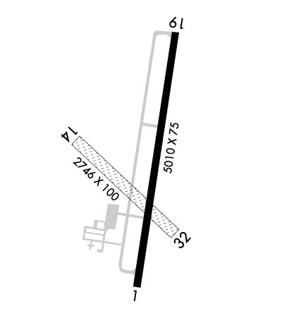 Airport Diagram might not be current. | |
| Facility Name: | BARABOO-WISCONSIN DELLS RGNL |
| City Name: | BARABOO |
| County: | SAUK |
| State abbrev: | WI |
| State Name: | WISCONSIN |
| Ownership: | PUBLICLY OWNED |
| Use: | OPEN TO THE PUBLIC |
| Owner's Name: | AIRPORT COMMISSION; CITY OF BARABOO; CITY OF WISCONSIN DELLS - TOWN & VILLAGE OF LAKE DELTON. |
| Address: | 101 SOUTH BLVD |
| BARABOO, WI 53913 | |
| Owner's Phone: | 608-355-2700 |
| Manager's Name: | BILL MURPHY |
| Address: | 101 SOUTH BLVD |
| BARABOO, WI 53913 | |
| Phone: | 608-356-2270 |
| FAA Region: | GREAT LAKES |
| FAA Field Office: | CHI |
| Date | Sunrise | Sunset |
|---|---|---|
| 09/24/21 Friday | 6:48 | 18:53 |
| 09/25/21 Saturday | 6:49 | 18:51 |
| 09/26/21 Sunday | 6:51 | 18:50 |
| 09/27/21 Monday | 6:52 | 18:48 |
| 09/28/21 Tuesday | 6:53 | 18:46 |
| 09/29/21 Wednesday | 6:54 | 18:44 |
| 09/30/21 Thursday | 6:55 | 18:42 |
| 10/01/21 Friday | 6:56 | 18:41 |
| 10/02/21 Saturday | 6:57 | 18:39 |
| 10/03/21 Sunday | 6:59 | 18:37 |
| 10/04/21 Monday | 7:00 | 18:35 |
| 10/05/21 Tuesday | 7:01 | 18:33 |
| 10/06/21 Wednesday | 7:02 | 18:32 |
| 10/07/21 Thursday | 7:03 | 18:30 |
| Airport Attendance Schedule | MAY-SEP 7 Days A Week 0800-1900, OCT-APR 7 Days A Week 0800-1700 |
| Airport Status | OPERATIONAL (This Status can change at any time - please check NOTAMS) |
| Airport Lighting Schedule | MIRL RY 01/19 PRESET ON LOW INTST; TO INCR INTST & ACTVT REIL RY 01/19 AND PAPI RY 01/19 - CTAF. |
| Airport Storage Available | Tie Downs, Hanger |
| Extra Services Available | Flight Instruction |
| Wind Indicator | YES - (unlit) |
| Control Tower | NO |
| CTAF Frequency | 123.050 |
| Unicom Frequency | 123.050 |
| Rotating Beacon Color | CLEAR-GREEN (Light Land Airport) |
| Segmented Circle | YES |
| Landing Fee | NO |
| Airport Inspected | STATE - performed by STATE AERONAUTICAL PERSONNEL |
| Inspection Date | 04/09/2021 |
| Type of Fuel Available | Grade 100LL, JET A (freeze point -40C); -1024 HR FUEL AVBL WITH CREDIT CARD. |
| Airframe Repair Service | MAJOR |
| Power Plant Repair Service | MAJOR |
| Latitude | N4331.3 |
| Longitude | W08946.3 (ESTIMATED) |
| Arpt Elevation | 979ft (SURVEYED) |
| Magnetic Variation | 01W |
| 3 miles NW | of BARABOO |
| Traffic Pattern Altitude | |
| Sectional Chart | CHICAGO |
| Operations (Reported) | Yearly | Avg. Daily |
|---|---|---|
| General Aviation Transient | 19000 | 52 |
| General Aviation Local | 7500 | 21 |
| Air Taxi | 1000 | 3 |
| Commerical | 0 | 0 |
| Commuter | 0 | 0 |
| Military | 2500 | 7 |
| Aircraft based on Field | |
|---|---|
| General Aviation Singles | 45 |
| General Aviation Multi | 3 |
| Jet Aircraft | 4 |
| General Aviation Helicopters | 0 |
| Military Aircraft | 0 |
| Gliders | 1 |
| Ultralights | 0 |
| FSS on field | NO |
| FSS tie-in | GREEN BAY |
| FSS Phone | 1-800-WX-BRIEF |
| Who issues Notams | DLL |
| Notam D service at airport | YES |
| ARTCC Name | CHICAGO |
| Airport Certification | |
| Aircraft Rescue & Firefighting Index | None |
| Airport of Entry | No |
| Custom Landing Rights | No |
| Joint Civil/Military | No |
| Military Landing rights | YES |
| NATIONAL PLAN OF INTEGRATED AIRPORT SYSTEMS (NPIAS) |
| GRANT AGREEMENTS UNDER FAAP/ADAP/AIP |
| ASSURANCES PURSUANT TO TITLE VI, CIVIL RIGHTS ACT OF 1964 |
| BIRDS ON & INVOF ARPT IN FALL. |
| FOR CD IF UNA TO CTC ON FSS FREQ, CTC CHICAGO ARTCC AT 630-906-8921. |
| RWY 14/3 2 MARKED BY YELLOW & BLACK A-FRAMES. NOT PLOWED & CLSD NOV 15 THRU APR 15; CONFIRM STATUS CTC - 608-356-2270. |
Airport Communications & Frequencies:
| |||||||||||||||||
| Runway: 01 | Runway: 19 | ||
| Mag heading: | 10° | Mag heading: | 190° |
| Rwy Slope: | -.19% Down | Rwy Slope: | .19% Up |
| Approach: | LOC/DME | Approach: | |
| Pattern: | Left Traffic | Pattern: | Left Traffic |
| Markings: | NONPRECISION INSTRUMENT | Markings: | NONPRECISION INSTRUMENT |
| Marking Condition: | GOOD | Marking Condition: | GOOD |
| Arresting Dev: | Arresting Dev: | ||
| Lat & Long: | N4330.9 W08946.3 | Lat. & Long.: | N4331.8 W08946.1 |
| Elev: | 976.8 ft. MSL | Elev: | 967.2 ft. MSL |
| TCH: | 32 ft. AGL | TCH: | 32 ft. AGL |
| Visual Glide Path: | 3.00 degrees | Visual Glide Path: | 3.00 degrees |
| Displaced Threshold: | No | Displaced Threshold: | No |
| Touchdown Zone: | YES | Touchdown Zone: | YES |
| Touchdown Elev.: | 979.3 feet | Touchdown Elev.: | 978.7 feet |
| Visual Glide Slope: | 2-Light PAPI on LEFT side of Runway; PAPI UNUSBL BYD 8 DEGS LEFT OF CNTRLN. | Visual Glide Slope: | 2-Light PAPI on LEFT side of Runway |
| RVR Equipment: | RVR Equipment: | ||
| RVV Equipment: | NO | RVV Equipment: | NO |
| Approach Lights: | Approach Lights: | ||
| REIL: | YES | REIL: | YES |
| Centerline Lights: | NO | Centerline Lights: | NO |
| Touchdown lights: | NO | Touchdown lights: | NO |
| Runway Category: | Runway with a Non-precision Approach having visibility minimums greater than 3/4 mile | Runway Category: | Runway with a Non-precision Approach having visibility minimums greater than 3/4 mile |
| Declared Distances: | Declared Distances: | ||
| Obstructions: | Obstructions: | TREES | |
| Marked: | Marked: | NOT Marked/Lighted | |
| Clearance slope: | 34:1 | Clearance slope: | 22:1 |
| Obstruction height: | Obstruction height: | 65 feet AGL | |
| Dist. from runway: | Dist. from runway: | 1630 feet | |
| Centerline offset: | Centerline offset: | 350 feet left of centerline | |
| Comments: | Comments: |
| Runway: 14 | Runway: 32 | ||
| Mag heading: | 135° | Mag heading: | 315° |
| Rwy Slope: | .20% Up | Rwy Slope: | -.20% Down |
| Approach: | Approach: | ||
| Pattern: | Left Traffic | Pattern: | Left Traffic |
| Markings: | NONE | Markings: | NONE |
| Marking Condition: | Marking Condition: | ||
| Arresting Dev: | Arresting Dev: | ||
| Lat & Long: | N4331.4 W08946.6 | Lat. & Long.: | N4331.1 W08946.2 |
| Elev: | 971.8 ft. MSL | Elev: | 977.2 ft. MSL |
| TCH: | TCH: | ||
| Visual Glide Path: | Visual Glide Path: | ||
| Displaced Threshold: | No | Displaced Threshold: | No |
| Touchdown Zone: | YES | Touchdown Zone: | YES |
| Touchdown Elev.: | 979.3 feet | Touchdown Elev.: | 979.3 feet |
| Visual Glide Slope: | Visual Glide Slope: | ||
| RVR Equipment: | RVR Equipment: | ||
| RVV Equipment: | NO | RVV Equipment: | NO |
| Approach Lights: | Approach Lights: | ||
| REIL: | NO | REIL: | NO |
| Centerline Lights: | NO | Centerline Lights: | NO |
| Touchdown lights: | NO | Touchdown lights: | NO |
| Runway Category: | Runway with a Visual Approach | Runway Category: | Runway with a Visual Approach |
| Declared Distances: | Declared Distances: | ||
| Obstructions: | TREE | Obstructions: | |
| Marked: | NOT Marked/Lighted | Marked: | |
| Clearance slope: | 15:1 | Clearance slope: | 20:1 |
| Obstruction height: | 41 feet AGL | Obstruction height: | |
| Dist. from runway: | 620 feet | Dist. from runway: | |
| Centerline offset: | 170 right of centerline | Centerline offset: | |
| Comments: | Comments: |
Thanks for using FltPlan.com
all rights reserved © 1999-2021 by Flight Plan LLC
