
| CHAUTAUQUA COUNTY/DUNKIRK DUNKIRK NY |
| |
| Lat: N 4229.6 Long: W 07916.3 Elev: 692. Var: +10 Longest Runway: 6000 | ||
| AWOS: 119.27 CTAF: 123.07 | ||
| ||||||||||||||||||||||||||||||||||||||||||||
| ||||||||||||||||||||||||||||||||||||||||||||
| ||||||||||||||||||||||||||||||||||||||||||||
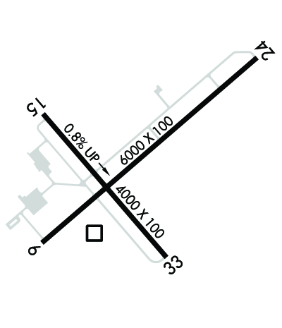
| Rwy | Rwy | |||||||
| 6000x100 | 6000' | 6000x100 | 6000' | |||||
| 4000x100 | 4000' | 4000x100 | 4000' | |||||
| Runway ID | Single Wheel | Double Wheel | Double Tandem Wheel | Dual Double Wheel |
| 06/24 | 49,600 | 68,000 | 130,000 | N/A |
| 15/33 | 49,600 | 68,000 | 130,000 | N/A |
| These numbers are Advisory and are not limits. The Airport Manager should have more accurate Weight Limits | ||||
 Airport Diagram might not be current. | |
| Facility Name: | CHAUTAUQUA COUNTY/DUNKIRK |
| City Name: | DUNKIRK |
| County: | CHAUTAUQUA |
| State abbrev: | NY |
| State Name: | NEW YORK |
| Ownership: | PUBLICLY OWNED |
| Use: | OPEN TO THE PUBLIC |
| Owner's Name: | CHAUT CO |
| Address: | N. ERIE STREET |
| MAYVILLE, NY 14701 | |
| Owner's Phone: | 716-753-8406 |
| Manager's Name: | JOHN MACHEMER |
| Address: | 3163 AIRPORT DR |
| JAMESTOWN, NY 14701 | |
| Phone: | 716-581-0062 |
| FAA Region: | EASTERN |
| FAA Field Office: | NYC |
| Date | Sunrise | Sunset |
|---|---|---|
| 06/08/26 Monday | 5:40 | 20:52 |
| 06/09/26 Tuesday | 5:40 | 20:53 |
| 06/10/26 Wednesday | 5:40 | 20:54 |
| 06/11/26 Thursday | 5:39 | 20:54 |
| 06/12/26 Friday | 5:39 | 20:55 |
| 06/13/26 Saturday | 5:39 | 20:55 |
| 06/14/26 Sunday | 5:39 | 20:56 |
| 06/15/26 Monday | 5:39 | 20:56 |
| 06/16/26 Tuesday | 5:39 | 20:56 |
| 06/17/26 Wednesday | 5:39 | 20:57 |
| 06/18/26 Thursday | 5:39 | 20:57 |
| 06/19/26 Friday | 5:39 | 20:57 |
| 06/20/26 Saturday | 5:40 | 20:58 |
| 06/21/26 Sunday | 5:40 | 20:58 |
| Airport Attendance Schedule | 7 Days A Week 0700-1700; EXC FEDERAL HOLS. |
| Airport Status | OPERATIONAL (This Status can change at any time - please check NOTAMS) |
| Airport Lighting Schedule | ACTVT HIRL RWY 06/24, MIRL RWY 15/33, PAPI 06, 24, 15, & 33, & REIL RWY 6 & 24 -CTAF. |
| Airport Storage Available | Tie Downs, Hanger |
| Extra Services Available | NONE |
| Wind Indicator | YES - (lighted) |
| Control Tower | NO |
| CTAF Frequency | 123.075 |
| Unicom Frequency | 123.075 |
| Rotating Beacon Color | WG |
| Segmented Circle | YES |
| Landing Fee | NO |
| Airport Inspected | STATE - performed by PRIVATE CONTRACT PERSONNEL |
| Inspection Date | 07/11/2024 |
| Type of Fuel Available | Grade 100LL, JET A (freeze point -40C), JET A |
| Airframe Repair Service | MINOR |
| Power Plant Repair Service | MAJOR |
| Latitude | N4229.6 |
| Longitude | W07916.3 (ESTIMATED) |
| Arpt Elevation | 692ft (SURVEYED) |
| Magnetic Variation | 10W |
| 3 miles E | of DUNKIRK |
| Traffic Pattern Altitude | |
| Sectional Chart | DETROIT |
| Operations (Reported) | Yearly | Avg. Daily |
|---|---|---|
| General Aviation Transient | 0 | 0 |
| General Aviation Local | 0 | 0 |
| Air Taxi | 0 | 0 |
| Commerical | 0 | 0 |
| Commuter | 0 | 0 |
| Military | 0 | 0 |
| Aircraft based on Field | |
|---|---|
| General Aviation Singles | 0 |
| General Aviation Multi | 0 |
| Jet Aircraft | 0 |
| General Aviation Helicopters | 0 |
| Military Aircraft | 0 |
| Gliders | 0 |
| Ultralights | 0 |
| FSS on field | NO |
| FSS tie-in | BUFFALO |
| FSS Phone | 1-800-WX-BRIEF |
| Who issues Notams | DKK |
| Notam D service at airport | YES |
| ARTCC Name | CLEVELAND |
| Airport Certification | |
| Aircraft Rescue & Firefighting Index | None |
| Airport of Entry | No |
| Custom Landing Rights | No |
| Joint Civil/Military | No |
| Military Landing rights | YES |
| NATIONAL PLAN OF INTEGRATED AIRPORT SYSTEMS (NPIAS) |
| GRANT AGREEMENTS UNDER FAAP/ADAP/AIP |
| ASSURANCES PURSUANT TO TITLE VI, CIVIL RIGHTS ACT OF 1964 |
| AGREEMENT UNDER DLAND OR DCLA HAS EXPIRED. |
| DEER & BIRDS INVOF AIRPORT |
| FICONS NOT RGLRLY MNT. |
| COLD TEMPERATURE AIRPORT. ALTITUDE CORRECTION REQUIRED AT OR BELOW -21C. |
| FOR CD CTC BUFFALO ATCT AT 716-626-6939/6919. |
Airport Communications & Frequencies:
| ||||||||||||||
| Runway: 06 | Runway: 24 | ||
| Mag heading: | 59° | Mag heading: | 239° |
| Rwy Slope: | -.21% Down | Rwy Slope: | .21% Up |
| Approach: | Approach: | ||
| Pattern: | Left Traffic | Pattern: | Left Traffic |
| Markings: | NONPRECISION INSTRUMENT | Markings: | NONPRECISION INSTRUMENT |
| Marking Condition: | FAIR | Marking Condition: | FAIR |
| Arresting Dev: | Arresting Dev: | ||
| Lat & Long: | N4229.4 W07916.7 | Lat. & Long.: | N4230.0 W07915.7 |
| Elev: | 673.9 ft. MSL | Elev: | 661.5 ft. MSL |
| TCH: | 43 ft. AGL | TCH: | 44 ft. AGL |
| Visual Glide Path: | 3.00 degrees | Visual Glide Path: | 3.00 degrees |
| Displaced Threshold: | No | Displaced Threshold: | No |
| Touchdown Zone: | YES | Touchdown Zone: | YES |
| Touchdown Elev.: | 676.8 feet | Touchdown Elev.: | 673.2 feet |
| Visual Glide Slope: | 4-Light PAPI on LEFT side of Runway | Visual Glide Slope: | 4-Light PAPI on LEFT side of Runway |
| RVR Equipment: | RVR Equipment: | ||
| RVV Equipment: | NO | RVV Equipment: | NO |
| Approach Lights: | Approach Lights: | ||
| REIL: | YES | REIL: | YES |
| Centerline Lights: | NO | Centerline Lights: | NO |
| Touchdown lights: | NO | Touchdown lights: | NO |
| Runway Category: | Runway with a Visual Approach | Runway Category: | Runway with a Non-precision Approach having visibility minimums greater than 3/4 mile |
| Declared Distances: | Declared Distances: | ||
| Obstructions: | Obstructions: | TREE | |
| Marked: | Marked: | NOT Marked/Lighted | |
| Clearance slope: | 20:1 | Clearance slope: | 6:1 |
| Obstruction height: | Obstruction height: | 30 feet AGL | |
| Dist. from runway: | Dist. from runway: | 405 feet | |
| Centerline offset: | Centerline offset: | 44 feet right of centerline | |
| Comments: | Comments: |
| Runway: 15 | Runway: 33 | ||
| Mag heading: | 149° | Mag heading: | 329° |
| Rwy Slope: | .80% Up | Rwy Slope: | -.80% Down |
| Approach: | Approach: | ||
| Pattern: | Left Traffic | Pattern: | Left Traffic |
| Markings: | NONPRECISION INSTRUMENT | Markings: | NONPRECISION INSTRUMENT |
| Marking Condition: | FAIR | Marking Condition: | FAIR |
| Arresting Dev: | Arresting Dev: | ||
| Lat & Long: | N4229.8 W07916.7 | Lat. & Long.: | N4229.3 W07916.1 |
| Elev: | 660.4 ft. MSL | Elev: | 692.3 ft. MSL |
| TCH: | 36 ft. AGL | TCH: | 45 ft. AGL |
| Visual Glide Path: | 3.00 degrees | Visual Glide Path: | 3.10 degrees |
| Displaced Threshold: | No | Displaced Threshold: | No |
| Touchdown Zone: | YES | Touchdown Zone: | YES |
| Touchdown Elev.: | 684.1 feet | Touchdown Elev.: | 692.3 feet |
| Visual Glide Slope: | 4-Light PAPI on LEFT side of Runway | Visual Glide Slope: | 4-Light PAPI on LEFT side of Runway |
| RVR Equipment: | RVR Equipment: | ||
| RVV Equipment: | NO | RVV Equipment: | NO |
| Approach Lights: | Approach Lights: | ||
| REIL: | NO | REIL: | NO |
| Centerline Lights: | NO | Centerline Lights: | NO |
| Touchdown lights: | NO | Touchdown lights: | NO |
| Runway Category: | Runway with a Non-precision Approach having visibility minimums greater than 3/4 mile | Runway Category: | Runway with a Non-precision Approach having visibility minimums greater than 3/4 mile |
| Declared Distances: | Declared Distances: | ||
| Obstructions: | TREE | Obstructions: | TREES |
| Marked: | NOT Marked/Lighted | Marked: | NOT Marked/Lighted |
| Clearance slope: | 8:1 | Clearance slope: | 9:1 |
| Obstruction height: | 70 feet AGL | Obstruction height: | 62 feet AGL |
| Dist. from runway: | 787 feet | Dist. from runway: | 775 feet |
| Centerline offset: | 300 right of centerline | Centerline offset: | 273 feet right of centerline |
| Comments: | Comments: |
Thanks for using FltPlan.com
all rights reserved © 1999-2026 by Flight Plan LLC
