| DE KALB TAYLOR MUNI DE KALB IL |
| |
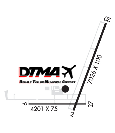
| Lat: N 4156.0 Long: W 08842.3 Elev: 913 Var: +02 Longest Runway: 7026 | ||
| AWOS: 119.07 CTAF: 122.7 | ||
| ||||||||||||||||||||||||||||||||||||||||||||||||||||||||||||||||||||
| ||||||||||||||||||||||||||||||||||||||||||||||||||||||||||||||||||||
| ||||||||||||||||||||||||||||||||||||||||||||||||||||||||||||||||||||
| Rwy | Rwy | |||||||
| 7026x100 | 7026' | 109.95 - 021° | 7026x100 | 7026' | ||||
| 4201x75 | 4201' | 4201x75 | 4201' | |||||
| Runway ID | Single Wheel | Double Wheel | Double Tandem Wheel | Dual Double Wheel |
| 02/20 | 25,000 | 80,000 | N/A | N/A |
| 09/27 | 25,000 | 80,000 | N/A | N/A |
| These numbers are Advisory and are not limits. The Airport Manager should have more accurate Weight Limits | ||||
 Airport Diagram might not be current. | |
| Facility Name: | DE KALB TAYLOR MUNI |
| City Name: | DE KALB |
| County: | DE KALB |
| State abbrev: | IL |
| State Name: | ILLINOIS |
| Ownership: | PUBLICLY OWNED |
| Use: | OPEN TO THE PUBLIC |
| Owner's Name: | CITY OF DEKALB |
| Address: | 164 EAST LINCOLN HWY |
| DEKALB, IL 60115 | |
| Owner's Phone: | 815-748-2000 |
| Manager's Name: | RENEE RIANI |
| Address: | 3232 PLEASANT STREET |
| DEKALB, IL 60115 | |
| Phone: | 815-748-8102 |
| FAA Region: | GREAT LAKES |
| FAA Field Office: | CHI |

| Date | Sunrise | Sunset |
|---|---|---|
| 09/24/21 Friday | 6:44 | 18:49 |
| 09/25/21 Saturday | 6:45 | 18:47 |
| 09/26/21 Sunday | 6:46 | 18:45 |
| 09/27/21 Monday | 6:47 | 18:44 |
| 09/28/21 Tuesday | 6:48 | 18:42 |
| 09/29/21 Wednesday | 6:49 | 18:40 |
| 09/30/21 Thursday | 6:50 | 18:39 |
| 10/01/21 Friday | 6:51 | 18:37 |
| 10/02/21 Saturday | 6:53 | 18:35 |
| 10/03/21 Sunday | 6:54 | 18:33 |
| 10/04/21 Monday | 6:55 | 18:32 |
| 10/05/21 Tuesday | 6:56 | 18:30 |
| 10/06/21 Wednesday | 6:57 | 18:28 |
| 10/07/21 Thursday | 6:58 | 18:27 |
| Airport Attendance Schedule | 7 Days A Week 0730-1730 |
| Airport Status | OPERATIONAL (This Status can change at any time - please check NOTAMS) |
| Airport Lighting Schedule | MIRL RY 02/20 PRESET LOW INTST, TO INCR INTST & ACTVT MIRL RY 09/27, PAPI RY 09 & PVASI 27, REIL RYS 9, 27, & 20, AND MALSR RY 02 - CTAF. PAPI RYS 02 & 20 OPERATE 24 HRS. |
| Airport Storage Available | Tie Downs, Hanger |
| Extra Services Available | Air Freight, Cargo Handling, Flight Instruction, Aircraft Rental |
| Wind Indicator | YES - (lighted) |
| Control Tower | NO |
| CTAF Frequency | 122.700 |
| Unicom Frequency | 122.700 |
| Rotating Beacon Color | CLEAR-GREEN (Light Land Airport) |
| Segmented Circle | NO |
| Landing Fee | NO |
| Airport Inspected | STATE - performed by STATE AERONAUTICAL PERSONNEL |
| Inspection Date | 03/23/2021 |
| Type of Fuel Available | Grade 100LL, JET A-1 (icing inhibitor, freeze point -50C) |
| Airframe Repair Service | MAJOR |
| Power Plant Repair Service | MAJOR |
| Latitude | N4156.0 |
| Longitude | W08842.3 (ESTIMATED) |
| Arpt Elevation | 912ft (SURVEYED) |
| Magnetic Variation | 02W |
| 2 miles E | of DE KALB |
| Traffic Pattern Altitude | |
| Sectional Chart | CHICAGO |
| Operations (Reported) | Yearly | Avg. Daily |
|---|---|---|
| General Aviation Transient | 19700 | 54 |
| General Aviation Local | 6220 | 17 |
| Air Taxi | 1080 | 3 |
| Commerical | 0 | 0 |
| Commuter | 0 | 0 |
| Military | 0 | 0 |
| Aircraft based on Field | |
|---|---|
| General Aviation Singles | 60 |
| General Aviation Multi | 11 |
| Jet Aircraft | 0 |
| General Aviation Helicopters | 0 |
| Military Aircraft | 0 |
| Gliders | 0 |
| Ultralights | 0 |
| FSS on field | NO |
| FSS tie-in | KANKAKEE |
| FSS Phone | 1-800-WX-BRIEF |
| Who issues Notams | DKB |
| Notam D service at airport | YES |
| ARTCC Name | CHICAGO |
| Airport Certification | |
| Aircraft Rescue & Firefighting Index | None |
| Airport of Entry | No |
| Custom Landing Rights | No |
| Joint Civil/Military | No |
| Military Landing rights | YES |
| NATIONAL PLAN OF INTEGRATED AIRPORT SYSTEMS (NPIAS) |
| GRANT AGREEMENTS UNDER FAAP/ADAP/AIP |
| SURPLUS PROPERTY AGREEMENT UNDER REGULATION 16-WAA |
| ASSURANCES PURSUANT TO TITLE VI, CIVIL RIGHTS ACT OF 1964 |
| FOR CD CTC CHICAGO APCH AT 847-289-0926. |
Airport Communications & Frequencies:
| ||||||||||||||
| Runway: 02 | Runway: 20 | ||
| Mag heading: | 21° | Mag heading: | 201° |
| Rwy Slope: | -.13% Down | Rwy Slope: | .13% Up |
| Approach: | ILS/DME | Approach: | |
| Pattern: | Left Traffic | Pattern: | Left Traffic |
| Markings: | PRECISION INSTRUMENT | Markings: | NONPRECISION INSTRUMENT |
| Marking Condition: | FAIR | Marking Condition: | FAIR |
| Arresting Dev: | Arresting Dev: | ||
| Lat & Long: | N4155.7 W08842.4 | Lat. & Long.: | N4156.7 W08841.9 |
| Elev: | 912.6 ft. MSL | Elev: | 903.7 ft. MSL |
| TCH: | 55 ft. AGL | TCH: | 27 ft. AGL |
| Visual Glide Path: | 3.00 degrees | Visual Glide Path: | 3.00 degrees |
| Displaced Threshold: | No | Displaced Threshold: | No |
| Touchdown Zone: | YES | Touchdown Zone: | YES |
| Touchdown Elev.: | 912.6 feet | Touchdown Elev.: | 905.0 feet |
| Visual Glide Slope: | 2-Light PAPI on LEFT side of Runway | Visual Glide Slope: | 2-Light PAPI on LEFT side of Runway |
| RVR Equipment: | RVR Equipment: | ||
| RVV Equipment: | NO | RVV Equipment: | NO |
| Approach Lights: | MALSR - 1,400 foot medium intensity approach lighting system with runway alignment indicator lights | Approach Lights: | |
| REIL: | NO | REIL: | YES |
| Centerline Lights: | NO | Centerline Lights: | NO |
| Touchdown lights: | NO | Touchdown lights: | NO |
| Runway Category: | Precision Instrument Runway | Runway Category: | D |
| Declared Distances: | Declared Distances: | ||
| Obstructions: | RR | Obstructions: | |
| Marked: | NOT Marked/Lighted | Marked: | |
| Clearance slope: | 50:1 | Clearance slope: | 34:1 |
| Obstruction height: | 21 feet AGL | Obstruction height: | |
| Dist. from runway: | 1237 feet | Dist. from runway: | |
| Centerline offset: | 650 right of centerline | Centerline offset: | |
| Comments: | Comments: |
| Runway: 09 | Runway: 27 | ||
| Mag heading: | 91° | Mag heading: | 271° |
| Rwy Slope: | .01% Up | Rwy Slope: | -.01% Down |
| Approach: | Approach: | ||
| Pattern: | Left Traffic | Pattern: | Left Traffic |
| Markings: | NONPRECISION INSTRUMENT | Markings: | NONPRECISION INSTRUMENT |
| Marking Condition: | FAIR | Marking Condition: | FAIR |
| Arresting Dev: | Arresting Dev: | ||
| Lat & Long: | N4155.7 W08843.1 | Lat. & Long.: | N4155.7 W08842.2 |
| Elev: | 911.4 ft. MSL | Elev: | 911.7 ft. MSL |
| TCH: | 30 ft. AGL | TCH: | 22 ft. AGL |
| Visual Glide Path: | 3.00 degrees | Visual Glide Path: | 3.00 degrees |
| Displaced Threshold: | No | Displaced Threshold: | No |
| Touchdown Zone: | YES | Touchdown Zone: | YES |
| Touchdown Elev.: | 911.6 feet | Touchdown Elev.: | 911.7 feet |
| Visual Glide Slope: | 4-Light PAPI on LEFT side of Runway | Visual Glide Slope: | PULSATING/STEADY BURNING VASI ON LEFT SIDE OF RUNWAY |
| RVR Equipment: | RVR Equipment: | ||
| RVV Equipment: | NO | RVV Equipment: | NO |
| Approach Lights: | Approach Lights: | ||
| REIL: | YES | REIL: | YES |
| Centerline Lights: | NO | Centerline Lights: | NO |
| Touchdown lights: | NO | Touchdown lights: | NO |
| Runway Category: | Runway with a Non-precision Approach having visibility minimums greater than 3/4 mile | Runway Category: | D |
| Declared Distances: | Declared Distances: |
Thanks for using FltPlan.com
all rights reserved © 1999-2021 by Flight Plan LLC