
| DICKINSON-ROOSEVELT REGL DICKINSON ND |
| |
| Lat: N 4648.1 Long: W 10248.2 Elev: 2592 Var: -10 Longest Runway: 7301 | ||
| AWOS: 118.37 CTAF: 123.0 | ||
| ||||||||||||||||||||||||||||||||||||||||||||
| ||||||||||||||||||||||||||||||||||||||||||||
| ||||||||||||||||||||||||||||||||||||||||||||
| Rwy | Rwy | |||||||
| 4700x75 | 4700' | 4700x75 | 4700' | |||||
| 7301x100 | 7301' | 7301x100 | 7301' | |||||
| Runway ID | Single Wheel | Double Wheel | Double Tandem Wheel | Dual Double Wheel |
| 07/25 | 16,000 | 20,000 | N/A | N/A |
| 15/33 | 89,000 | 60,000 | 89,000 | N/A |
| These numbers are Advisory and are not limits. The Airport Manager should have more accurate Weight Limits | ||||
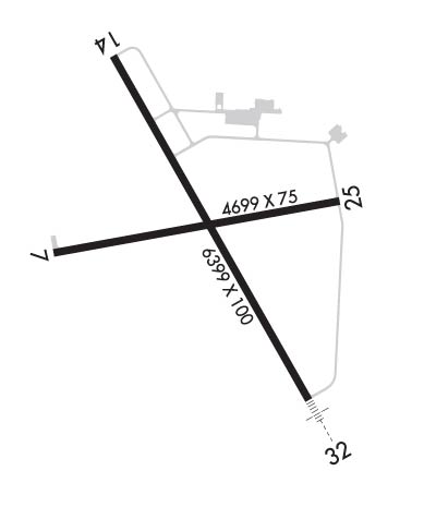 Airport Diagram might not be current. | |
| Facility Name: | DICKINSON - THEODORE ROOSEVELT RGNL |
| City Name: | DICKINSON |
| County: | STARK |
| State abbrev: | ND |
| State Name: | NORTH DAKOTA |
| Ownership: | PUBLICLY OWNED |
| Use: | OPEN TO THE PUBLIC |
| Owner's Name: | DICKINSON ARPT AUTHORITY |
| Address: | 11120 42ND ST SW |
| DICKINSON, ND 58601-9282 | |
| Owner's Phone: | 701-483-1062 |
| Manager's Name: | KELLY BRAUN |
| Address: | 11120 42ND ST SW |
| DICKINSON, ND 58601-9282 | |
| Phone: | 701-483-1062 |
| FAA Region: | GREAT LAKES |
| FAA Field Office: | DMA |
| Date | Sunrise | Sunset |
|---|---|---|
| 09/24/21 Friday | 6:40 | 18:45 |
| 09/25/21 Saturday | 6:42 | 18:43 |
| 09/26/21 Sunday | 6:43 | 18:41 |
| 09/27/21 Monday | 6:44 | 18:39 |
| 09/28/21 Tuesday | 6:46 | 18:37 |
| 09/29/21 Wednesday | 6:47 | 18:35 |
| 09/30/21 Thursday | 6:48 | 18:33 |
| 10/01/21 Friday | 6:50 | 18:31 |
| 10/02/21 Saturday | 6:51 | 18:29 |
| 10/03/21 Sunday | 6:52 | 18:27 |
| 10/04/21 Monday | 6:54 | 18:25 |
| 10/05/21 Tuesday | 6:55 | 18:23 |
| 10/06/21 Wednesday | 6:56 | 18:21 |
| 10/07/21 Thursday | 6:58 | 18:20 |
| Airport Attendance Schedule | 7 Days A Week 0700-1600; FOR SVC AFT HRS CALL (701) 264-9966. |
| Airport Status | OPERATIONAL (This Status can change at any time - please check NOTAMS) |
| Airport Lighting Schedule | MIRL RWYS 07/25 & 15/33 PRESET ON LOW INTST DUSK-2200; TO INCR INTST AFT 2200 - CTAF. REIL RWY 07, 15, 25, & 33; PAPI RWYS 07, 15, 25, & 33 - CTAF. |
| Airport Storage Available | Tie Downs, Hanger |
| Extra Services Available | Crop Dusting, Air Ambulance, Charter, Flight Instruction, Aircraft Rental, Aircraft Sales, Annual Surveying |
| Wind Indicator | YES - (lighted) |
| Control Tower | NO |
| CTAF Frequency | 123.000 |
| Unicom Frequency | 123.000 |
| Rotating Beacon Color | CLEAR-GREEN (Light Land Airport) |
| Segmented Circle | YES |
| Landing Fee | NO |
| Airport Inspected | STATE - performed by FAA AIRPORTS FIELD PERSONNEL |
| Inspection Date | 10/25/2019 |
| Type of Fuel Available | Grade 100LL, JET A (freeze point -40C) |
| Airframe Repair Service | MAJOR |
| Power Plant Repair Service | MAJOR |
| Latitude | N4648.1 |
| Longitude | W10248.2 (ESTIMATED) |
| Arpt Elevation | 2592ft (SURVEYED) |
| Magnetic Variation | 10E |
| 5 miles S | of DICKINSON |
| Traffic Pattern Altitude | 1010; TPA SNGL ENG 1010 FT AGL; MULT ENG 1510 FT AGL. |
| Sectional Chart | BILLINGS |
| Operations (Reported) | Yearly | Avg. Daily |
|---|---|---|
| General Aviation Transient | 10368 | 28 |
| General Aviation Local | 4130 | 11 |
| Air Taxi | 1044 | 3 |
| Commerical | 1460 | 4 |
| Commuter | 0 | 0 |
| Military | 112 | 0 |
| Aircraft based on Field | |
|---|---|
| General Aviation Singles | 28 |
| General Aviation Multi | 4 |
| Jet Aircraft | 1 |
| General Aviation Helicopters | 1 |
| Military Aircraft | 0 |
| Gliders | 0 |
| Ultralights | 0 |
| FSS on field | NO |
| FSS tie-in | GRAND FORKS |
| FSS Phone | 1-800-WX-BRIEF |
| Who issues Notams | DIK |
| Notam D service at airport | YES |
| ARTCC Name | MINNEAPOLIS |
| Airport Certification | AIRPORT RECEIVING SCHEDULED AIR CARRIER SERVICE FROM CARRIERS CERTIFICATED BY THE CIVIL AERONAUTICS BOARD |
| Aircraft Rescue & Firefighting Index | AIRPORT HAS A CERTIFICATE UNDER CFR PART 139 |
| Airport of Entry | No |
| Custom Landing Rights | No |
| Joint Civil/Military | No |
| Military Landing rights | YES |
| NATIONAL PLAN OF INTEGRATED AIRPORT SYSTEMS (NPIAS) |
| GRANT AGREEMENTS UNDER FAAP/ADAP/AIP |
| ASSURANCES PURSUANT TO TITLE VI, CIVIL RIGHTS ACT OF 1964 |
| AGREEMENT UNDER DLAND OR DCLA HAS EXPIRED. |
| HAYING OPNS ADJ TO ALL SFCS JUN - SEP. |
| CROP DUSTING OPNS INVOF ARPT. |
| PAEW ON MOVEMENT AREAS DURG WINTER (OCT-APR). |
| CTC AMGR FOR WT RSTRN WAIVER 701-483-1062. |
| AIRFIELD SFC CONDS UNMON BTN 2300-0430. |
| CAUTION: UNLIT TOWER 295.9 FEET AGL (3045.9 FEET MSL), 20.5 NM WNW OF AIRPORT. |
| FOR CD IF UNA TO CTC ON FSS FREQ, CTC MINNEAPOLIS ARTCC AT 651-463-5588. |
| BIRDS ON & INVOF ARPT. |
| CONC APRON FOR HEAVY ACFT PARKING. |
| RWY 07/2 5 RWY 7/25 NOT AVBL FOR SKEDD ACR OPNS WITH MORE THAN 9 PSGR SEATS OR UNSKED ACR AT LEAST 31 PSGR SEATS. |
Airport Communications & Frequencies:
| |||||||||
| Runway: 07 | Runway: 25 | ||
| Mag heading: | 70° | Mag heading: | 250° |
| Rwy Slope: | .43% Up | Rwy Slope: | -.43% Down |
| Approach: | Approach: | ||
| Pattern: | Left Traffic | Pattern: | Left Traffic |
| Markings: | NONPRECISION INSTRUMENT | Markings: | NONPRECISION INSTRUMENT |
| Marking Condition: | FAIR | Marking Condition: | GOOD |
| Arresting Dev: | Arresting Dev: | ||
| Lat & Long: | N4647.8 W10248.7 | Lat. & Long.: | N4647.9 W10247.6 |
| Elev: | 2571.7 ft. MSL | Elev: | 2592.1 ft. MSL |
| TCH: | 28 ft. AGL | TCH: | 28 ft. AGL |
| Visual Glide Path: | 3.00 degrees | Visual Glide Path: | 3.00 degrees |
| Displaced Threshold: | No | Displaced Threshold: | No |
| Touchdown Zone: | YES | Touchdown Zone: | YES |
| Touchdown Elev.: | 2582.6 feet | Touchdown Elev.: | 2592.1 feet |
| Visual Glide Slope: | 2-Light PAPI on LEFT side of Runway | Visual Glide Slope: | 2-Light PAPI on LEFT side of Runway |
| RVR Equipment: | RVR Equipment: | ||
| RVV Equipment: | NO | RVV Equipment: | NO |
| Approach Lights: | Approach Lights: | ||
| REIL: | YES | REIL: | YES |
| Centerline Lights: | NO | Centerline Lights: | NO |
| Touchdown lights: | NO | Touchdown lights: | NO |
| Runway Category: | Runway with a Non-precision Approach | Runway Category: | Runway with a Non-precision Approach |
| Declared Distances: | TORA:4700' TODA:4700' ASDA:4700' LDA:4700' | Declared Distances: | TORA:4700' TODA:4700' ASDA:4700' LDA:4700' |
| Obstructions: | Obstructions: | ROAD | |
| Marked: | Marked: | NOT Marked/Lighted | |
| Clearance slope: | 50:1 | Clearance slope: | 21:1 |
| Obstruction height: | Obstruction height: | 28 feet AGL | |
| Dist. from runway: | Dist. from runway: | 790 feet | |
| Centerline offset: | Centerline offset: | 300 feet left of centerline | |
| Comments: | Comments: |
| Runway: 15 | Runway: 33 | ||
| Mag heading: | 140° | Mag heading: | 320° |
| Rwy Slope: | -.01% Down | Rwy Slope: | .01% Up |
| Approach: | Approach: | ||
| Pattern: | Left Traffic | Pattern: | Left Traffic |
| Markings: | NONPRECISION INSTRUMENT | Markings: | NONPRECISION INSTRUMENT |
| Marking Condition: | GOOD | Marking Condition: | GOOD |
| Arresting Dev: | Arresting Dev: | ||
| Lat & Long: | N4648.7 W10248.7 | Lat. & Long.: | N4647.7 W10247.8 |
| Elev: | 2581.5 ft. MSL | Elev: | 2581.0 ft. MSL |
| TCH: | 43 ft. AGL | TCH: | 47 ft. AGL |
| Visual Glide Path: | 3.00 degrees | Visual Glide Path: | 3.09 degrees |
| Displaced Threshold: | No | Displaced Threshold: | No |
| Touchdown Zone: | YES | Touchdown Zone: | YES |
| Touchdown Elev.: | 2585.7 feet | Touchdown Elev.: | 2586.2 feet |
| Visual Glide Slope: | 4-Light PAPI on LEFT side of Runway | Visual Glide Slope: | 4-Light PAPI on LEFT side of Runway |
| RVR Equipment: | RVR Equipment: | ||
| RVV Equipment: | NO | RVV Equipment: | NO |
| Approach Lights: | Approach Lights: | ||
| REIL: | YES | REIL: | YES |
| Centerline Lights: | NO | Centerline Lights: | NO |
| Touchdown lights: | NO | Touchdown lights: | NO |
| Runway Category: | D | Runway Category: | D |
| Declared Distances: | TORA:7301' TODA:7301' ASDA:7301' LDA:7301' | Declared Distances: | TORA:7301' TODA:7301' ASDA:7301' LDA:7301' |
| Obstructions: | POLE | Obstructions: | ROAD |
| Marked: | NOT Marked/Lighted | Marked: | NOT Marked/Lighted |
| Clearance slope: | 38:1 | Clearance slope: | 50:1 |
| Obstruction height: | 65 feet AGL | Obstruction height: | 37 feet AGL |
| Dist. from runway: | 2686 feet | Dist. from runway: | 2344 feet |
| Centerline offset: | 676 left of centerline | Centerline offset: | 666 feet right of centerline |
| Comments: | Comments: |
Thanks for using FltPlan.com
all rights reserved © 1999-2021 by Flight Plan LLC
