
| DALHART MUNI DALHART TX |
| |
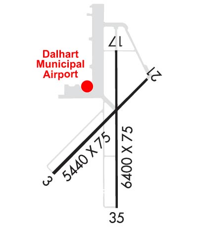
| Lat: N 3601.3 Long: W 10232.8 Elev: 3991 Var: -09 Longest Runway: 6400 | ||
| AWOS: 134.07 CTAF: 122.95 | ||
| |||||||||||||||||||||||
| |||||||||||||||||||||||
| |||||||||||||||||||||||
| |||||||||||||||||||||||
| Rwy | Rwy | |||||||
| 5440x75 | 5440' | 5440x75 | 5440' | |||||
| 6400x75 | 6400' | 6400x75 | 6400' | |||||
| Runway ID | Single Wheel | Double Wheel | Double Tandem Wheel | Dual Double Wheel |
| 03/21 | 30,000 | N/A | N/A | N/A |
| 17/35 | 20,000 | 30,000 | N/A | N/A |
| These numbers are Advisory and are not limits. The Airport Manager should have more accurate Weight Limits | ||||
 Airport Diagram might not be current. | |
| Facility Name: | DALHART MUNI |
| City Name: | DALHART |
| County: | HARTLEY |
| State abbrev: | TX |
| State Name: | TEXAS |
| Ownership: | PUBLICLY OWNED |
| Use: | OPEN TO THE PUBLIC |
| Owner's Name: | CITY OF DALHART |
| Address: | PO BOX 2005 |
| DALHART, TX 79022 | |
| Owner's Phone: | 806-244-5511 |
| Manager's Name: | JAMES STROUD; CITY MGR. |
| Address: | PO BOX 2005 |
| DALHART, TX 79022 | |
| Phone: | 806-244-5511 |
| FAA Region: | SOUTHWEST |
| FAA Field Office: | TEX |

| Date | Sunrise | Sunset |
|---|---|---|
| 09/24/21 Friday | 7:39 | 19:44 |
| 09/25/21 Saturday | 7:40 | 19:43 |
| 09/26/21 Sunday | 7:41 | 19:41 |
| 09/27/21 Monday | 7:42 | 19:40 |
| 09/28/21 Tuesday | 7:43 | 19:38 |
| 09/29/21 Wednesday | 7:43 | 19:37 |
| 09/30/21 Thursday | 7:44 | 19:36 |
| 10/01/21 Friday | 7:45 | 19:34 |
| 10/02/21 Saturday | 7:46 | 19:33 |
| 10/03/21 Sunday | 7:47 | 19:31 |
| 10/04/21 Monday | 7:48 | 19:30 |
| 10/05/21 Tuesday | 7:48 | 19:28 |
| 10/06/21 Wednesday | 7:49 | 19:27 |
| 10/07/21 Thursday | 7:50 | 19:26 |
| Airport Attendance Schedule | 7 Days A Week DAWN-DUSK |
| Airport Status | OPERATIONAL (This Status can change at any time - please check NOTAMS) |
| Airport Lighting Schedule | MIRL RYS 03/21 & 17/35 PRESET LOW INTST; TO INCR INTST & ACTVT PAPI RYS 17 & 35 - CTAF. |
| Airport Storage Available | Tie Downs, Hanger |
| Extra Services Available | Crop Dusting, Flight Instruction |
| Wind Indicator | YES - (lighted) |
| Control Tower | NO |
| CTAF Frequency | 122.950 |
| Unicom Frequency | 122.950 |
| Rotating Beacon Color | CLEAR-GREEN (Light Land Airport) |
| Segmented Circle | YES |
| Landing Fee | NO |
| Airport Inspected | STATE - performed by STATE AERONAUTICAL PERSONNEL |
| Inspection Date | 10/11/2017 |
| Type of Fuel Available | Grade 100LL, JET A-1 (freeze point -50C); -10FOR FUEL AFT HRS CALL 806-244-5521. |
| Airframe Repair Service | MAJOR |
| Power Plant Repair Service | MAJOR |
| Latitude | N3601.3 |
| Longitude | W10232.8 (ESTIMATED) |
| Arpt Elevation | 3991ft (SURVEYED) |
| Magnetic Variation | 09E |
| 3 miles SW | of DALHART |
| Traffic Pattern Altitude | |
| Sectional Chart | WICHITA |
| Operations (Reported) | Yearly | Avg. Daily |
|---|---|---|
| General Aviation Transient | 2500 | 7 |
| General Aviation Local | 5000 | 14 |
| Air Taxi | 0 | 0 |
| Commerical | 0 | 0 |
| Commuter | 0 | 0 |
| Military | 150 | 0 |
| Aircraft based on Field | |
|---|---|
| General Aviation Singles | 32 |
| General Aviation Multi | 5 |
| Jet Aircraft | 0 |
| General Aviation Helicopters | 1 |
| Military Aircraft | 0 |
| Gliders | 1 |
| Ultralights | 0 |
| FSS on field | NO |
| FSS tie-in | FORT WORTH |
| FSS Phone | 1-800-WX-BRIEF |
| Who issues Notams | DHT |
| Notam D service at airport | YES |
| ARTCC Name | ALBUQUERQUE |
| Airport Certification | |
| Aircraft Rescue & Firefighting Index | None |
| Airport of Entry | No |
| Custom Landing Rights | No |
| Joint Civil/Military | No |
| Military Landing rights | YES |
| NATIONAL PLAN OF INTEGRATED AIRPORT SYSTEMS (NPIAS) |
| GRANT AGREEMENTS UNDER FAAP/ADAP/AIP |
| SURPLUS PROPERTY AGREEMENT UNDER REGULATION 16-WAA |
| ASSURANCES PURSUANT TO TITLE VI, CIVIL RIGHTS ACT OF 1964 |
| LARGE FLOCKS OF WATERFOWL INVOF LAKE RITA BLANCA 2 MI EAST DURING FALL. |
| FOR CD IF UNA TO CTC ON FSS FREQ, CTC ALBUQUERQUE ARTCC AT 505-856-4561. |
Airport Communications & Frequencies:
| |||||||||
| Runway: 03 | Runway: 21 | ||
| Mag heading: | 36° | Mag heading: | 216° |
| Rwy Slope: | -.02% Down | Rwy Slope: | .02% Up |
| Approach: | Approach: | ||
| Pattern: | Left Traffic | Pattern: | Left Traffic |
| Markings: | BASIC | Markings: | BASIC |
| Marking Condition: | FAIR | Marking Condition: | FAIR |
| Arresting Dev: | Arresting Dev: | ||
| Lat & Long: | N3601.0 W10233.3 | Lat. & Long.: | N3601.7 W10232.5 |
| Elev: | 3983.2 ft. MSL | Elev: | 3982.3 ft. MSL |
| TCH: | TCH: | ||
| Visual Glide Path: | Visual Glide Path: | ||
| Displaced Threshold: | No | Displaced Threshold: | No |
| Touchdown Zone: | YES | Touchdown Zone: | YES |
| Touchdown Elev.: | 3987.9 feet | Touchdown Elev.: | 3988.5 feet |
| Visual Glide Slope: | Visual Glide Slope: | ||
| RVR Equipment: | RVR Equipment: | ||
| RVV Equipment: | NO | RVV Equipment: | NO |
| Approach Lights: | Approach Lights: | ||
| REIL: | NO | REIL: | NO |
| Centerline Lights: | NO | Centerline Lights: | NO |
| Touchdown lights: | NO | Touchdown lights: | NO |
| Runway Category: | Runway with a Visual Approach | Runway Category: | Runway with a Visual Approach |
| Declared Distances: | Declared Distances: | ||
| Obstructions: | Obstructions: | ANT | |
| Marked: | Marked: | NOT Marked/Lighted | |
| Clearance slope: | 50:1 | Clearance slope: | 10:1 |
| Obstruction height: | Obstruction height: | 7 feet AGL | |
| Dist. from runway: | Dist. from runway: | 271 feet | |
| Centerline offset: | Centerline offset: | 227 feet right of centerline | |
| Comments: | Comments: | 16 FT TREE 91 FT FM THLD, 141 FT LEFT |
| Runway: 17 | Runway: 35 | ||
| Mag heading: | 171° | Mag heading: | 351° |
| Rwy Slope: | -.07% Down | Rwy Slope: | .07% Up |
| Approach: | Approach: | ||
| Pattern: | Left Traffic | Pattern: | Left Traffic |
| Markings: | NONPRECISION INSTRUMENT | Markings: | NONPRECISION INSTRUMENT |
| Marking Condition: | FAIR | Marking Condition: | FAIR |
| Arresting Dev: | Arresting Dev: | ||
| Lat & Long: | N3601.9 W10232.8 | Lat. & Long.: | N3600.8 W10232.8 |
| Elev: | 3991.0 ft. MSL | Elev: | 3986.7 ft. MSL |
| TCH: | 25 ft. AGL | TCH: | 39 ft. AGL |
| Visual Glide Path: | 3.00 degrees | Visual Glide Path: | 3.00 degrees |
| Displaced Threshold: | No | Displaced Threshold: | No |
| Touchdown Zone: | YES | Touchdown Zone: | YES |
| Touchdown Elev.: | 3991.1 feet | Touchdown Elev.: | 3988.4 feet |
| Visual Glide Slope: | 4-Light PAPI on LEFT side of Runway; PAPI OTS. | Visual Glide Slope: | 4-Light PAPI on LEFT side of Runway |
| RVR Equipment: | RVR Equipment: | ||
| RVV Equipment: | NO | RVV Equipment: | NO |
| Approach Lights: | Approach Lights: | ||
| REIL: | YES | REIL: | YES |
| Centerline Lights: | NO | Centerline Lights: | NO |
| Touchdown lights: | NO | Touchdown lights: | NO |
| Runway Category: | D | Runway Category: | D |
| Declared Distances: | Declared Distances: |
Thanks for using FltPlan.com
all rights reserved © 1999-2021 by Flight Plan LLC
