
| WILLIAM H. MORSE STATE BENNINGTON VT |
| |
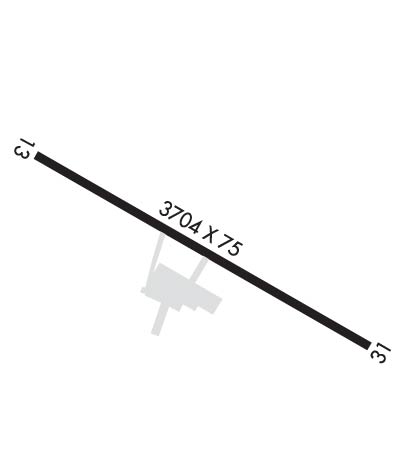
| Lat: N 4253.5 Long: W 07314.8 Elev: 827 Var: +14 Longest Runway: 3704 | ||
| AWOS: 135.92 CTAF: 122.8 | ||
| ||||||
| ||||||
|
| Rwy | Rwy | |||||||
| 3704x75 | 3704' | 3704x75 | 3704' | |||||
| Runway ID | Single Wheel | Double Wheel | Double Tandem Wheel | Dual Double Wheel |
| 13/31 | 12,500 | N/A | N/A | N/A |
| These numbers are Advisory and are not limits. The Airport Manager should have more accurate Weight Limits | ||||
 Airport Diagram might not be current. | |
| Facility Name: | WILLIAM H MORSE STATE |
| City Name: | BENNINGTON |
| County: | BENNINGTON |
| State abbrev: | VT |
| State Name: | VERMONT |
| Ownership: | PUBLICLY OWNED |
| Use: | OPEN TO THE PUBLIC |
| Owner's Name: | STATE OF VERMONT |
| Address: | RUTLAND SVR AIRPORT, 1002 AIRPORT ROAD |
| NO. CLARENDON, VT 05759-5001 | |
| Owner's Phone: | (802) 786-8881 |
| Manager's Name: | ROB LUTHER |
| Address: | 1563 WALLOOMSACK ROAD |
| BENNINGTON, VT 05201 | |
| Phone: | 802-442-5503 |
| FAA Region: | NEW ENGLAND |
| FAA Field Office: | NONE |
| Date | Sunrise | Sunset |
|---|---|---|
| 09/24/21 Friday | 6:42 | 18:47 |
| 09/25/21 Saturday | 6:43 | 18:45 |
| 09/26/21 Sunday | 6:44 | 18:44 |
| 09/27/21 Monday | 6:45 | 18:42 |
| 09/28/21 Tuesday | 6:47 | 18:40 |
| 09/29/21 Wednesday | 6:48 | 18:38 |
| 09/30/21 Thursday | 6:49 | 18:36 |
| 10/01/21 Friday | 6:50 | 18:35 |
| 10/02/21 Saturday | 6:51 | 18:33 |
| 10/03/21 Sunday | 6:52 | 18:31 |
| 10/04/21 Monday | 6:53 | 18:29 |
| 10/05/21 Tuesday | 6:54 | 18:28 |
| 10/06/21 Wednesday | 6:56 | 18:26 |
| 10/07/21 Thursday | 6:57 | 18:24 |
| Airport Attendance Schedule | SAT-SUN ON CALL, MON-FRI 0800-1600; FOR ARPT ATNDNC CALL 1-802-442-5503 OR 1-802-595-5830 FOR ON-CALL SVCS ONLY. |
| Airport Status | OPERATIONAL (This Status can change at any time - please check NOTAMS) |
| Airport Lighting Schedule | ACTVT REIL RWY 13 & 31; PAPI RWY 13 & 31; MIRL RWY 13/31 - CTAF. |
| Airport Storage Available | Tie Downs, Hanger, Buoys |
| Extra Services Available | NONE |
| Wind Indicator | YES - (lighted) |
| Control Tower | NO |
| CTAF Frequency | 122.800 |
| Unicom Frequency | 122.800 |
| Rotating Beacon Color | CLEAR-GREEN (Light Land Airport) |
| Segmented Circle | YES |
| Landing Fee | NO |
| Airport Inspected | STATE - performed by STATE AERONAUTICAL PERSONNEL |
| Inspection Date | 10/13/2017 |
| Type of Fuel Available | Grade 100LL, JET A (freeze point -40C); -10100LL SELF-SVC AVBL 24 HRS. |
| Airframe Repair Service | MAJOR |
| Power Plant Repair Service | MAJOR |
| Latitude | N4253.5 |
| Longitude | W07314.8 (ESTIMATED) |
| Arpt Elevation | 826ft (SURVEYED) |
| Magnetic Variation | 14W |
| 3 miles W | of BENNINGTON |
| Traffic Pattern Altitude | |
| Sectional Chart | NEW YORK |
| Operations (Reported) | Yearly | Avg. Daily |
|---|---|---|
| General Aviation Transient | 8627 | 24 |
| General Aviation Local | 5625 | 15 |
| Air Taxi | 0 | 0 |
| Commerical | 0 | 0 |
| Commuter | 0 | 0 |
| Military | 125 | 0 |
| Aircraft based on Field | |
|---|---|
| General Aviation Singles | 15 |
| General Aviation Multi | 2 |
| Jet Aircraft | 0 |
| General Aviation Helicopters | 0 |
| Military Aircraft | 0 |
| Gliders | 0 |
| Ultralights | 0 |
| FSS on field | NO |
| FSS tie-in | BURLINGTON |
| FSS Phone | 1-800-WX-BRIEF |
| Who issues Notams | DDH |
| Notam D service at airport | YES |
| ARTCC Name | BOSTON |
| Airport Certification | |
| Aircraft Rescue & Firefighting Index | None |
| Airport of Entry | No |
| Custom Landing Rights | No |
| Joint Civil/Military | No |
| Military Landing rights | YES |
| NATIONAL PLAN OF INTEGRATED AIRPORT SYSTEMS (NPIAS) |
| GRANT AGREEMENTS UNDER FAAP/ADAP/AIP |
| ASSURANCES PURSUANT TO TITLE VI, CIVIL RIGHTS ACT OF 1964 |
| THIS AIRPORT HAS BEEN SURVEYED BY THE NATIONAL GEODETIC SURVEY. |
| RWY CONDS MAY NOT BE MNT OR RPRTD WHEN ARPT IS UNATNDD. |
| FOR CD CTC ALBANY APCH AT 518-862-2299. |
| NOISE ABATEMENT PROCS IN EFCT. AVOID OVER FLYING HOMES SE OF ARPT. NOISE SENSITIVE AREA AER 31. PREFERRED USE RWY IS RWY 13. IF PRACTICAL ACFT DEP RWY 13 USE BEST CLIMB RATE & WHEN ABOVE 400 FT AGL TURN LEFT WITHIN 1 MILE OF DER 13. |
| GEESE ON & INVOF ARPT. |
| GCO AVBL ON FREQ 121.725 THRU BTV CD & FLT SVCS. OTS INDEFLY. |
| RWY 13 THR HAZUS BIRD ACTVTY. |
| MTS ALL QUADS. |
| TFC PAT OPNS PROHIBITED SOUTH OF RWY 13 & RWY 31. |
| COLD TEMPERATURE AIRPORT. ALTITUDE CORRECTION REQUIRED AT OR BELOW -14C. |
Airport Communications & Frequencies:
| ||||||||||||||
| Runway: 13 | Runway: 31 | ||
| Mag heading: | 132° | Mag heading: | 312° |
| Rwy Slope: | .88% Up | Rwy Slope: | -.88% Down |
| Approach: | Approach: | ||
| Pattern: | Left Traffic | Pattern: | Right Traffic |
| Markings: | NONPRECISION INSTRUMENT | Markings: | BASIC |
| Marking Condition: | FAIR | Marking Condition: | FAIR |
| Arresting Dev: | Arresting Dev: | ||
| Lat & Long: | N4253.6 W07315.1 | Lat. & Long.: | N4253.3 W07314.4 |
| Elev: | 794.2 ft. MSL | Elev: | 826.9 ft. MSL |
| TCH: | 45 ft. AGL | TCH: | 45 ft. AGL |
| Visual Glide Path: | 4.00 degrees | Visual Glide Path: | 4.00 degrees |
| Displaced Threshold: | No | Displaced Threshold: | No |
| Touchdown Zone: | YES | Touchdown Zone: | YES |
| Touchdown Elev.: | 819.2 feet | Touchdown Elev.: | 826.9 feet |
| Visual Glide Slope: | 4-Light PAPI on LEFT side of Runway | Visual Glide Slope: | 4-Light PAPI on RIGHT side of Runway |
| RVR Equipment: | RVR Equipment: | ||
| RVV Equipment: | NO | RVV Equipment: | NO |
| Approach Lights: | Approach Lights: | ||
| REIL: | YES | REIL: | YES |
| Centerline Lights: | NO | Centerline Lights: | NO |
| Touchdown lights: | NO | Touchdown lights: | NO |
| Runway Category: | Runway with a Non-precision Approach | Runway Category: | Runway with a Visual Approach |
| Declared Distances: | Declared Distances: | ||
| Obstructions: | HILL | Obstructions: | GND |
| Marked: | NOT Marked/Lighted | Marked: | NOT Marked/Lighted |
| Clearance slope: | 16:1 | Clearance slope: | 7:1 |
| Obstruction height: | 159 feet AGL | Obstruction height: | 40 feet AGL |
| Dist. from runway: | 2781 feet | Dist. from runway: | 509 feet |
| Centerline offset: | 549 right of centerline | Centerline offset: | 178 feet left of centerline |
| Comments: | Comments: | +20 FT GND, 250 FT RIGHT OF CNTRLN. |
Thanks for using FltPlan.com
all rights reserved © 1999-2021 by Flight Plan LLC
