
| BARSTOW-DAGGETT DAGGETT CA |
| |
| Lat: N 3451.2 Long: W 11647.2 Elev: 1930 Var: -15 Longest Runway: 6402 | ||
| AWOS: 132.17 CTAF: 123.0 | ||
| ||||||||||||||||||||||||||||||||||||||||||||
| ||||||||||||||||||||||||||||||||||||||||||||
| ||||||||||||||||||||||||||||||||||||||||||||
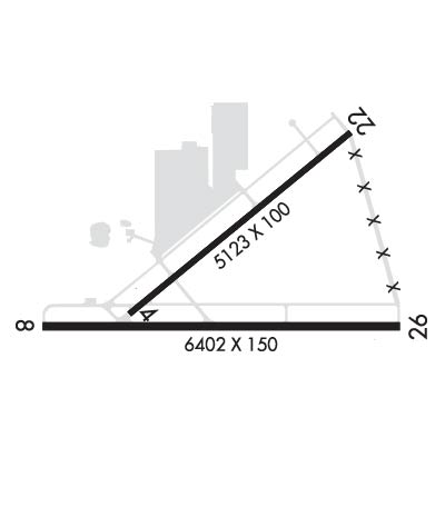
| Rwy | Rwy | |||||||
| 5123x100 | 5123' | 5123x100 | 5123' | |||||
| 6402x150 | 6402' | 6402x150 | 6402' | |||||
| Runway ID | Single Wheel | Double Wheel | Double Tandem Wheel | Dual Double Wheel |
| 04/22 | 30,000 | 105,000 | 190,000 | N/A |
| 08/26 | 30,000 | 170,000 | 320,000 | N/A |
| These numbers are Advisory and are not limits. The Airport Manager should have more accurate Weight Limits | ||||
 Airport Diagram might not be current. | |
| Facility Name: | BARSTOW-DAGGETT |
| City Name: | DAGGETT |
| County: | SAN BERNARDINO |
| State abbrev: | CA |
| State Name: | CALIFORNIA |
| Ownership: | PUBLICLY OWNED |
| Use: | OPEN TO THE PUBLIC |
| Owner's Name: | COUNTY OF SAN BERNARDINO |
| Address: | |
| SAN BERNARDINO, CA 92415 | |
| Owner's Phone: | 909-387-8810 |
| Manager's Name: | MAUREEN SNELGROVE |
| Address: | 777 EAST RIALTO AVE. |
| SAN BERNARDINO, CA 92415 | |
| Phone: | 909-387-8810 |
| FAA Region: | WESTERN-PACIFIC |
| FAA Field Office: | LAX |

| Date | Sunrise | Sunset |
|---|---|---|
| 09/24/21 Friday | 6:36 | 18:41 |
| 09/25/21 Saturday | 6:37 | 18:40 |
| 09/26/21 Sunday | 6:38 | 18:38 |
| 09/27/21 Monday | 6:39 | 18:37 |
| 09/28/21 Tuesday | 6:39 | 18:36 |
| 09/29/21 Wednesday | 6:40 | 18:34 |
| 09/30/21 Thursday | 6:41 | 18:33 |
| 10/01/21 Friday | 6:42 | 18:31 |
| 10/02/21 Saturday | 6:42 | 18:30 |
| 10/03/21 Sunday | 6:43 | 18:29 |
| 10/04/21 Monday | 6:44 | 18:27 |
| 10/05/21 Tuesday | 6:45 | 18:26 |
| 10/06/21 Wednesday | 6:46 | 18:24 |
| 10/07/21 Thursday | 6:46 | 18:23 |
| Airport Attendance Schedule | 7 Days A Week 0630-1700 |
| Airport Status | OPERATIONAL (This Status can change at any time - please check NOTAMS) |
| Airport Lighting Schedule | ACTVT MIRL RWY 4/22 & 8/26 - CTAF. PAPI RWY 08, 22, & 26 OPR CONSLY. |
| Airport Storage Available | Tie Downs |
| Extra Services Available | NONE |
| Wind Indicator | YES - (lighted) |
| Control Tower | NO |
| CTAF Frequency | 123.000 |
| Unicom Frequency | 123.000 |
| Rotating Beacon Color | CLEAR-GREEN (Light Land Airport) |
| Segmented Circle | YES |
| Landing Fee | NO |
| Airport Inspected | STATE - performed by STATE AERONAUTICAL PERSONNEL |
| Inspection Date | 04/16/2021 |
| Type of Fuel Available | Grade 100LL, JET A (freeze point -40C) |
| Airframe Repair Service | None |
| Power Plant Repair Service | None |
| Latitude | N3451.2 |
| Longitude | W11647.2 (ESTIMATED) |
| Arpt Elevation | 1930ft (SURVEYED) |
| Magnetic Variation | 15E |
| 4 miles E | of DAGGETT |
| Traffic Pattern Altitude | |
| Sectional Chart | LOS ANGELES |
| Operations (Reported) | Yearly | Avg. Daily |
|---|---|---|
| General Aviation Transient | 12200 | 33 |
| General Aviation Local | 6300 | 17 |
| Air Taxi | 0 | 0 |
| Commerical | 0 | 0 |
| Commuter | 0 | 0 |
| Military | 18000 | 49 |
| Aircraft based on Field | |
|---|---|
| General Aviation Singles | 5 |
| General Aviation Multi | 0 |
| Jet Aircraft | 0 |
| General Aviation Helicopters | 0 |
| Military Aircraft | 35 |
| Gliders | 0 |
| Ultralights | 0 |
| FSS on field | NO |
| FSS tie-in | RIVERSIDE |
| FSS Phone | 1-800-WX-BRIEF |
| Who issues Notams | DAG |
| Notam D service at airport | YES |
| ARTCC Name | LOS ANGELES |
| Airport Certification | |
| Aircraft Rescue & Firefighting Index | None |
| Airport of Entry | No |
| Custom Landing Rights | No |
| Joint Civil/Military | No |
| Military Landing rights | YES |
| NATIONAL PLAN OF INTEGRATED AIRPORT SYSTEMS (NPIAS) |
| SURPLUS PROPERTY AGREEMENT UNDER PUBLIC LAW 289 |
| AGREEMENT UNDER DLAND OR DCLA HAS EXPIRED. |
| E-W TWY PARALLEL TO RWY 08/26 WT BRG CPTY LIMITED TO S-12. |
| PAEW INVOF ARMY RAMP. EXTSV MILITARY HELICOPTER TRAFFIC INVOF ARPT. |
| FOR CD IF UNA TO CTC ON FSS FREQ, CTC LOS ANGELES ARTCC AT 661-575-2079. |
Airport Communications & Frequencies:
| |||||||||
| Runway: 04 | Runway: 22 | ||
| Mag heading: | 36° | Mag heading: | 216° |
| Rwy Slope: | -.28% Down | Rwy Slope: | .28% Up |
| Approach: | Approach: | ||
| Pattern: | Left Traffic | Pattern: | Left Traffic |
| Markings: | BASIC | Markings: | NONPRECISION INSTRUMENT |
| Marking Condition: | FAIR | Marking Condition: | GOOD |
| Arresting Dev: | Arresting Dev: | ||
| Lat & Long: | N3451.1 W11647.6 | Lat. & Long.: | N3451.7 W11646.8 |
| Elev: | 1922.9 ft. MSL | Elev: | 1908.7 ft. MSL |
| TCH: | TCH: | 49 ft. AGL | |
| Visual Glide Path: | Visual Glide Path: | 3.00 degrees | |
| Displaced Threshold: | No | Displaced Threshold: | No |
| Touchdown Zone: | YES | Touchdown Zone: | YES |
| Touchdown Elev.: | 1922.9 feet | Touchdown Elev.: | 1918.0 feet |
| Visual Glide Slope: | Visual Glide Slope: | 4-Light PAPI on LEFT side of Runway | |
| RVR Equipment: | RVR Equipment: | ||
| RVV Equipment: | NO | RVV Equipment: | NO |
| Approach Lights: | Approach Lights: | ||
| REIL: | NO | REIL: | NO |
| Centerline Lights: | NO | Centerline Lights: | NO |
| Touchdown lights: | NO | Touchdown lights: | NO |
| Runway Category: | Runway with a Visual Approach | Runway Category: | Runway with a Non-precision Approach having visibility minimums greater than 3/4 mile |
| Declared Distances: | Declared Distances: | ||
| Obstructions: | PLINE | Obstructions: | |
| Marked: | NOT Marked/Lighted | Marked: | |
| Clearance slope: | 32:1 | Clearance slope: | 50:1 |
| Obstruction height: | 75 feet AGL | Obstruction height: | |
| Dist. from runway: | 2625 feet | Dist. from runway: | |
| Centerline offset: | 300 left of centerline | Centerline offset: | |
| Comments: | Comments: |
| Runway: 08 | Runway: 26 | ||
| Mag heading: | 75° | Mag heading: | 255° |
| Rwy Slope: | -.33% Down | Rwy Slope: | .33% Up |
| Approach: | Approach: | ||
| Pattern: | Left Traffic | Pattern: | Left Traffic |
| Markings: | BASIC | Markings: | BASIC |
| Marking Condition: | FAIR | Marking Condition: | GOOD |
| Arresting Dev: | Arresting Dev: | ||
| Lat & Long: | N3451.1 W11647.9 | Lat. & Long.: | N3451.1 W11646.6 |
| Elev: | 1930.0 ft. MSL | Elev: | 1908.6 ft. MSL |
| TCH: | 50 ft. AGL | TCH: | 50 ft. AGL |
| Visual Glide Path: | 3.00 degrees | Visual Glide Path: | 3.00 degrees |
| Displaced Threshold: | No | Displaced Threshold: | No |
| Touchdown Zone: | YES | Touchdown Zone: | YES |
| Touchdown Elev.: | 1930.0 feet | Touchdown Elev.: | 1917.6 feet |
| Visual Glide Slope: | 4-Light PAPI on LEFT side of Runway | Visual Glide Slope: | 4-Light PAPI on LEFT side of Runway |
| RVR Equipment: | RVR Equipment: | ||
| RVV Equipment: | NO | RVV Equipment: | NO |
| Approach Lights: | Approach Lights: | ||
| REIL: | NO | REIL: | NO |
| Centerline Lights: | NO | Centerline Lights: | NO |
| Touchdown lights: | NO | Touchdown lights: | NO |
| Runway Category: | Runway with a Visual Approach | Runway Category: | Runway with a Non-precision Approach having visibility minimums greater than 3/4 mile |
| Declared Distances: | Declared Distances: |
Thanks for using FltPlan.com
all rights reserved © 1999-2021 by Flight Plan LLC