
| ROMEO STATE ROMEO MI |
| |
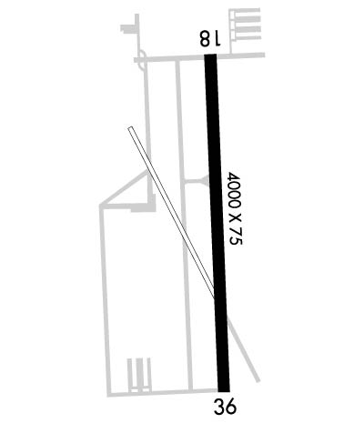
| Lat: N 4247.8 Long: W 08258.5 Elev: 739 Var: +06 Longest Runway: 4000 | ||
| CTAF: 122.8 | ||
| ||||||
|
| Rwy | Rwy | |||||||
| 4000x75 | 3530' | 4000x75 | 4000' | |||||
| Runway ID | Single Wheel | Double Wheel | Double Tandem Wheel | Dual Double Wheel |
| 18/36 | N/A | N/A | N/A | N/A |
| These numbers are Advisory and are not limits. The Airport Manager should have more accurate Weight Limits | ||||
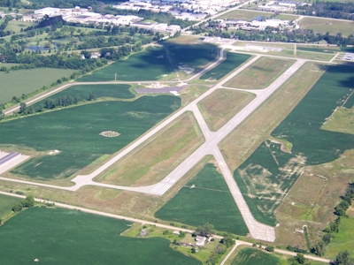
 Airport Diagram might not be current. | |
| Facility Name: | ROMEO STATE |
| City Name: | ROMEO |
| County: | MACOMB |
| State abbrev: | MI |
| State Name: | MICHIGAN |
| Ownership: | PUBLICLY OWNED |
| Use: | OPEN TO THE PUBLIC |
| Owner's Name: | STATE OF MICHIGAN |
| Address: | 2700 PORT LANSING RD |
| LANSING, MI 48906 | |
| Owner's Phone: | (517) 335-9841 |
| Manager's Name: | DONALD SCHORSCH |
| Address: | 15340 32 MILE RD. |
| RAY, MI 48096 | |
| Phone: | 586-336-9116; 586-337-5084 MGR CELL. |
| FAA Region: | GREAT LAKES |
| FAA Field Office: | DET |
| Date | Sunrise | Sunset |
|---|---|---|
| 09/24/21 Friday | 7:21 | 19:26 |
| 09/25/21 Saturday | 7:22 | 19:24 |
| 09/26/21 Sunday | 7:23 | 19:22 |
| 09/27/21 Monday | 7:24 | 19:21 |
| 09/28/21 Tuesday | 7:25 | 19:19 |
| 09/29/21 Wednesday | 7:27 | 19:17 |
| 09/30/21 Thursday | 7:28 | 19:15 |
| 10/01/21 Friday | 7:29 | 19:14 |
| 10/02/21 Saturday | 7:30 | 19:12 |
| 10/03/21 Sunday | 7:31 | 19:10 |
| 10/04/21 Monday | 7:32 | 19:08 |
| 10/05/21 Tuesday | 7:33 | 19:07 |
| 10/06/21 Wednesday | 7:34 | 19:05 |
| 10/07/21 Thursday | 7:36 | 19:03 |
| Airport Attendance Schedule | MON-FRI 0800-1600 |
| Airport Status | OPERATIONAL (This Status can change at any time - please check NOTAMS) |
| Airport Lighting Schedule | ACTVT MIRL, PAPI, REIL RY 18/36 - CTAF. |
| Airport Storage Available | Tie Downs, Hanger |
| Extra Services Available | Charter, Flight Instruction, Aircraft Rental |
| Wind Indicator | YES - (lighted) |
| Control Tower | NO |
| CTAF Frequency | 122.800 |
| Unicom Frequency | 122.800 |
| Rotating Beacon Color | CLEAR-GREEN (Light Land Airport) |
| Segmented Circle | NO |
| Landing Fee | NO |
| Airport Inspected | STATE - performed by STATE AERONAUTICAL PERSONNEL |
| Inspection Date | 09/09/2019 |
| Type of Fuel Available | Grade 100LL, JET A (freeze point -40C); -A 24 HR SELF SVC.; -1024 HR SELF SVC. |
| Airframe Repair Service | NONE |
| Power Plant Repair Service | NONE |
| Latitude | N4247.8 |
| Longitude | W08258.5 (ESTIMATED) |
| Arpt Elevation | 738ft (SURVEYED) |
| Magnetic Variation | 06W |
| 2 miles E | of ROMEO |
| Traffic Pattern Altitude | |
| Sectional Chart | DETROIT |
| Operations (Reported) | Yearly | Avg. Daily |
|---|---|---|
| General Aviation Transient | 7500 | 21 |
| General Aviation Local | 7500 | 21 |
| Air Taxi | 0 | 0 |
| Commerical | 0 | 0 |
| Commuter | 0 | 0 |
| Military | 0 | 0 |
| Aircraft based on Field | |
|---|---|
| General Aviation Singles | 30 |
| General Aviation Multi | 0 |
| Jet Aircraft | 0 |
| General Aviation Helicopters | 0 |
| Military Aircraft | 0 |
| Gliders | 0 |
| Ultralights | 0 |
| FSS on field | NO |
| FSS tie-in | LANSING |
| FSS Phone | 1-800-WX-BRIEF |
| Who issues Notams | LAN |
| Notam D service at airport | YES |
| ARTCC Name | CLEVELAND |
| Airport Certification | |
| Aircraft Rescue & Firefighting Index | None |
| Airport of Entry | No |
| Custom Landing Rights | No |
| Joint Civil/Military | No |
| Military Landing rights | No |
| NATIONAL PLAN OF INTEGRATED AIRPORT SYSTEMS (NPIAS) |
| DEER & BIRDS INVOF RY. |
| RY SFC COND UNMONITORED BTN 2100-1300Z++. |
| FOR APCH/DEP CTC CLEVELAND ARTCC AT 440-774-0229 WHEN SELFRIDGE APCH CTL CLSD. |
| FOR CD CTC CLEVELAND ARTCC AT 440-774-0490. |
Airport Communications & Frequencies:
| |||||||||||||||||
| Runway: 18 | Runway: 36 | ||
| Mag heading: | 184° | Mag heading: | 4° |
| Rwy Slope: | -.24% Down | Rwy Slope: | .24% Up |
| Approach: | Approach: | ||
| Pattern: | Left Traffic | Pattern: | Left Traffic |
| Markings: | NONPRECISION INSTRUMENT | Markings: | NONPRECISION INSTRUMENT |
| Marking Condition: | FAIR | Marking Condition: | FAIR |
| Arresting Dev: | Arresting Dev: | ||
| Lat & Long: | N4248.1 W08258.5 | Lat. & Long.: | N4247.5 W08258.4 |
| Elev: | 737.7 ft. MSL | Elev: | 728.3 ft. MSL |
| TCH: | 20 ft. AGL | TCH: | 22 ft. AGL |
| Visual Glide Path: | 3.00 degrees | Visual Glide Path: | 3.00 degrees |
| Displaced Threshold: | 470 feet | Displaced Threshold: | No |
| Touchdown Zone: | YES | Touchdown Zone: | YES |
| Touchdown Elev.: | 738.5 feet | Touchdown Elev.: | 735.7 feet |
| Visual Glide Slope: | 4-Light PAPI on LEFT side of Runway; PAPI RWY 18 OUT OF SERVICE INDEFINITELY. | Visual Glide Slope: | 4-Light PAPI on LEFT side of Runway |
| RVR Equipment: | RVR Equipment: | ||
| RVV Equipment: | NO | RVV Equipment: | NO |
| Approach Lights: | Approach Lights: | ||
| REIL: | YES | REIL: | YES |
| Centerline Lights: | NO | Centerline Lights: | NO |
| Touchdown lights: | NO | Touchdown lights: | NO |
| Runway Category: | Runway with a Non-precision Approach | Runway Category: | Runway with a Non-precision Approach |
| Declared Distances: | Declared Distances: | ||
| Obstructions: | TREES; 60 FT PLINE, 750 FT DSTC. | Obstructions: | ROAD |
| Marked: | NOT Marked/Lighted | Marked: | NOT Marked/Lighted |
| Clearance slope: | 10:1; APCH RATIO 21:1 AT DSPLCD THLD. | Clearance slope: | 12:1; APCH RATIO 27:1 FROM THLD. |
| Obstruction height: | 77 feet AGL | Obstruction height: | 13 feet AGL |
| Dist. from runway: | 1030 feet | Dist. from runway: | 358 feet |
| Centerline offset: | 80 left of centerline | Centerline offset: | |
| Comments: | Comments: |
Thanks for using FltPlan.com
all rights reserved © 1999-2021 by Flight Plan LLC