
| BOONVILLE BOONVILLE CA |
| |
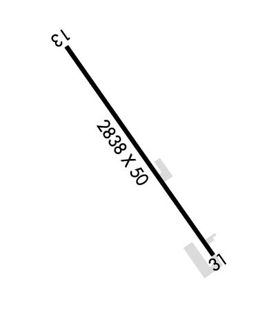
| Lat: N 3900.8 Long: W 12322.9 Elev: 379 Var: -17 Longest Runway: 2838 | ||
| CTAF: 122.7 | ||
| ||||||||||||||||||||||||||||||||
| ||||||||||||||||||||||||||||||||
| Rwy | Rwy | |||||||
| 2838x50 | 2585' | 2838x50 | 2743' | |||||
| Runway ID | Single Wheel | Double Wheel | Double Tandem Wheel | Dual Double Wheel |
| 13/31 | 30,000 | N/A | N/A | N/A |
| These numbers are Advisory and are not limits. The Airport Manager should have more accurate Weight Limits | ||||
| FltPlan does not have IFR approach charts available for KD83. |
 Airport Diagram might not be current. | |
| Facility Name: | BOONVILLE |
| City Name: | BOONVILLE |
| County: | MENDOCINO |
| State abbrev: | CA |
| State Name: | CALIFORNIA |
| Ownership: | PUBLICLY OWNED |
| Use: | OPEN TO THE PUBLIC |
| Owner's Name: | ANDERSON VALLEY COMM.SVC DST. |
| Address: | P.O. BOX 398 |
| BOONVILLE, CA 95415 | |
| Owner's Phone: | 707-895-2075 |
| Manager's Name: | KIRK WILDER |
| Address: | 13461 AIRPORT ROAD |
| BOONVILLE, CA 95415 | |
| Phone: | 707-895-2949 |
| FAA Region: | WESTERN-PACIFIC |
| FAA Field Office: | SFO |
| Date | Sunrise | Sunset |
|---|---|---|
| 09/24/21 Friday | 7:03 | 19:08 |
| 09/25/21 Saturday | 7:04 | 19:06 |
| 09/26/21 Sunday | 7:05 | 19:04 |
| 09/27/21 Monday | 7:06 | 19:03 |
| 09/28/21 Tuesday | 7:07 | 19:01 |
| 09/29/21 Wednesday | 7:07 | 19:00 |
| 09/30/21 Thursday | 7:08 | 18:58 |
| 10/01/21 Friday | 7:09 | 18:56 |
| 10/02/21 Saturday | 7:10 | 18:55 |
| 10/03/21 Sunday | 7:11 | 18:53 |
| 10/04/21 Monday | 7:12 | 18:52 |
| 10/05/21 Tuesday | 7:13 | 18:50 |
| 10/06/21 Wednesday | 7:14 | 18:49 |
| 10/07/21 Thursday | 7:15 | 18:47 |
| Airport Attendance Schedule | UNATTENDED |
| Airport Status | OPERATIONAL (This Status can change at any time - please check NOTAMS) |
| Airport Lighting Schedule | |
| Airport Storage Available | Tie Downs |
| Extra Services Available | NONE |
| Wind Indicator | YES - (unlit) |
| Control Tower | NO |
| CTAF Frequency | 122.700 |
| Unicom Frequency | 122.700 |
| Rotating Beacon Color | |
| Segmented Circle | YES |
| Landing Fee | NO |
| Airport Inspected | STATE - performed by STATE AERONAUTICAL PERSONNEL |
| Inspection Date | 01/29/2020 |
| Type of Fuel Available | None |
| Airframe Repair Service | NONE |
| Power Plant Repair Service | NONE |
| Latitude | N3900.8 |
| Longitude | W12322.9 (ESTIMATED) |
| Arpt Elevation | 378ft (ESTIMATED) |
| Magnetic Variation | 17E |
| 1 miles NW | of BOONVILLE |
| Traffic Pattern Altitude | 800 |
| Sectional Chart | SAN FRANCISCO |
| Operations (Reported) | Yearly | Avg. Daily |
|---|---|---|
| General Aviation Transient | 3000 | 8 |
| General Aviation Local | 2000 | 5 |
| Air Taxi | 0 | 0 |
| Commerical | 0 | 0 |
| Commuter | 0 | 0 |
| Military | 0 | 0 |
| Aircraft based on Field | |
|---|---|
| General Aviation Singles | 10 |
| General Aviation Multi | 0 |
| Jet Aircraft | 0 |
| General Aviation Helicopters | 0 |
| Military Aircraft | 0 |
| Gliders | 0 |
| Ultralights | 0 |
| FSS on field | NO |
| FSS tie-in | OAKLAND |
| FSS Phone | 1-800-WX-BRIEF |
| Who issues Notams | OAK |
| Notam D service at airport | YES |
| ARTCC Name | OAKLAND |
| Airport Certification | |
| Aircraft Rescue & Firefighting Index | None |
| Airport of Entry | No |
| Custom Landing Rights | No |
| Joint Civil/Military | No |
| Military Landing rights | No |
| NATIONAL PLAN OF INTEGRATED AIRPORT SYSTEMS (NPIAS) |
| DITCH SW SIDE OF RY 13/31. |
| BACK TAXI ON RY, DO NOT MISTAKE COUNTY ROAD FOR TWY. |
| FOR CD CTC OAKLAND ARTCC AT 510-745-3380. |
| RWY 13/3 1 PAVEMENT GROSS WEIGHT STRENGTH ESTIMATED BY ARPT MGR 12,500 LBS. |
| Runway: 13 | Runway: 31 | ||
| Mag heading: | N/A | Mag heading: | N/A |
| Rwy Slope: | .87% Up | Rwy Slope: | -.87% Down |
| Approach: | Approach: | ||
| Pattern: | Left Traffic | Pattern: | Right Traffic |
| Markings: | BASIC | Markings: | BASIC |
| Marking Condition: | GOOD | Marking Condition: | GOOD |
| Arresting Dev: | Arresting Dev: | ||
| Lat & Long: | N3901.0 W12323.1 | Lat. & Long.: | N3900.7 W12322.7 |
| Elev: | 353.9 ft. MSL | Elev: | 378.5 ft. MSL |
| TCH: | TCH: | ||
| Visual Glide Path: | Visual Glide Path: | ||
| Displaced Threshold: | 253 feet | Displaced Threshold: | 95 feet |
| Touchdown Zone: | NO | Touchdown Zone: | NO |
| Touchdown Elev.: | Touchdown Elev.: | ||
| Visual Glide Slope: | Visual Glide Slope: | ||
| RVR Equipment: | RVR Equipment: | ||
| RVV Equipment: | NO | RVV Equipment: | NO |
| Approach Lights: | Approach Lights: | ||
| REIL: | NO | REIL: | NO |
| Centerline Lights: | NO | Centerline Lights: | NO |
| Touchdown lights: | NO | Touchdown lights: | NO |
| Runway Category: | Runway with a Visual Approach | Runway Category: | Runway with a Visual Approach |
| Declared Distances: | Declared Distances: | ||
| Obstructions: | TREES | Obstructions: | HILL |
| Marked: | NOT Marked/Lighted | Marked: | NOT Marked/Lighted |
| Clearance slope: | 5:1; APCH RATIO 24:1 TO DSPLCD THLD; APCH RATIO TO DSPLD THLD OVER 92 FT TREES AT 1200 FT, 175 FT R FM EOR 18:1. | Clearance slope: | 20:1; APCH RATIO 22:1 TO DSPLCD THR; APCH RATIO TO DSPLCD THR OVER +15 FT ROAD 375 FT FM DSPLCD THR 125 FT LEFT 20:1. |
| Obstruction height: | 35 feet AGL | Obstruction height: | 185 feet AGL |
| Dist. from runway: | 400 feet | Dist. from runway: | 3900 feet |
| Centerline offset: | 20 left of centerline | Centerline offset: | 500 feet left of centerline |
| Comments: | 5' FENCE 250' FROM END OF RWY. | Comments: | PUBLIC ROAD 235' FM RWY END. |
Thanks for using FltPlan.com
all rights reserved © 1999-2021 by Flight Plan LLC
