
| MONROE-WALTON COUNTY MONROE GA |
| |
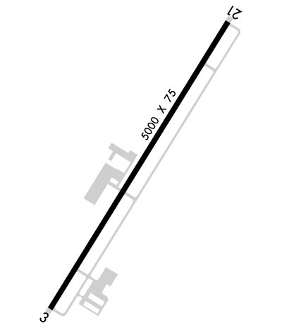
| Lat: N 3347.0 Long: W 08341.6 Elev: 875 Var: +04 Longest Runway: 5000 | ||
| AWOS: 392K CTAF: 122.9 | ||
| ||||||||||||||||||||||||||||||||||||||||||||
| ||||||||||||||||||||||||||||||||||||||||||||
| ||||||||||||||||||||||||||||||||||||||||||||
| ||||||||||||||||||||||||||||||||||||||||||||
| Rwy | Rwy | |||||||
| 5000x75 | 5000' | 5000x75 | 5000' | |||||
| Runway ID | Single Wheel | Double Wheel | Double Tandem Wheel | Dual Double Wheel |
| 03/21 | 14,500 | 18,000 | N/A | N/A |
| These numbers are Advisory and are not limits. The Airport Manager should have more accurate Weight Limits | ||||
 Airport Diagram might not be current. | |
| Facility Name: | CY NUNNALLY MEML |
| City Name: | MONROE |
| County: | WALTON |
| State abbrev: | GA |
| State Name: | GEORGIA |
| Ownership: | PUBLICLY OWNED |
| Use: | OPEN TO THE PUBLIC |
| Owner's Name: | CITY OF MONROE |
| Address: | CITY HALL, PO BOX 1249 |
| MONROE, GA 30655 | |
| Owner's Phone: | 770-267-7536 |
| Manager's Name: | CHRIS CROY |
| Address: | 215 NORTH BROAD STREET |
| MONROE, GA 30655 | |
| Phone: | 770-266-5172 |
| FAA Region: | SOUTHERN |
| FAA Field Office: | ATL |
| Date | Sunrise | Sunset |
|---|---|---|
| 06/08/26 Monday | 6:24 | 20:44 |
| 06/09/26 Tuesday | 6:24 | 20:44 |
| 06/10/26 Wednesday | 6:24 | 20:45 |
| 06/11/26 Thursday | 6:23 | 20:45 |
| 06/12/26 Friday | 6:23 | 20:46 |
| 06/13/26 Saturday | 6:23 | 20:46 |
| 06/14/26 Sunday | 6:24 | 20:47 |
| 06/15/26 Monday | 6:24 | 20:47 |
| 06/16/26 Tuesday | 6:24 | 20:47 |
| 06/17/26 Wednesday | 6:24 | 20:48 |
| 06/18/26 Thursday | 6:24 | 20:48 |
| 06/19/26 Friday | 6:24 | 20:48 |
| 06/20/26 Saturday | 6:24 | 20:48 |
| 06/21/26 Sunday | 6:24 | 20:49 |
| Airport Attendance Schedule | MON-FRI 0700-1700 |
| Airport Status | OPERATIONAL (This Status can change at any time - please check NOTAMS) |
| Airport Lighting Schedule | DUSK-2200. MIRL RY 03/21 PRESET LOW INTST DUSK-2200; TO INCR INTST & ACTVT MIRL RY 03/21 AND PAPI RYS 03 & 21 AFTER 2200 - CTAF. |
| Airport Storage Available | Tie Downs |
| Extra Services Available | Glider, Flight Instruction, Parachute Jumping |
| Wind Indicator | YES - (lighted) |
| Control Tower | NO |
| CTAF Frequency | 122.900 |
| Unicom Frequency | |
| Rotating Beacon Color | WG |
| Segmented Circle | YES |
| Landing Fee | NO |
| Airport Inspected | STATE - performed by STATE AERONAUTICAL PERSONNEL |
| Inspection Date | 03/27/2025 |
| Type of Fuel Available | Grade 100LL |
| Airframe Repair Service | MAJOR |
| Power Plant Repair Service | MAJOR |
| Latitude | N3347.0 |
| Longitude | W08341.6 (ESTIMATED) |
| Arpt Elevation | 875ft (SURVEYED) |
| Magnetic Variation | 04W |
| 1 miles SE | of MONROE |
| Traffic Pattern Altitude | |
| Sectional Chart | ATLANTA |
| Operations (Reported) | Yearly | Avg. Daily |
|---|---|---|
| General Aviation Transient | 0 | 0 |
| General Aviation Local | 0 | 0 |
| Air Taxi | 0 | 0 |
| Commerical | 0 | 0 |
| Commuter | 0 | 0 |
| Military | 0 | 0 |
| Aircraft based on Field | |
|---|---|
| General Aviation Singles | 0 |
| General Aviation Multi | 0 |
| Jet Aircraft | 0 |
| General Aviation Helicopters | 0 |
| Military Aircraft | 0 |
| Gliders | 0 |
| Ultralights | 0 |
| FSS on field | NO |
| FSS tie-in | MACON |
| FSS Phone | 1-800-WX-BRIEF |
| Who issues Notams | MCN |
| Notam D service at airport | YES |
| ARTCC Name | ATLANTA |
| Airport Certification | |
| Aircraft Rescue & Firefighting Index | None |
| Airport of Entry | No |
| Custom Landing Rights | No |
| Joint Civil/Military | No |
| Military Landing rights | YES |
| NATIONAL PLAN OF INTEGRATED AIRPORT SYSTEMS (NPIAS) |
| GRANT AGREEMENTS UNDER FAAP/ADAP/AIP |
| ASSURANCES PURSUANT TO TITLE VI, CIVIL RIGHTS ACT OF 1964 |
| GLIDER OPS 10 NM RADIUS SFC - 5000 FT. |
| DEER ON & INVOF ARPT. |
| FOR CD CTC ATLANTA APCH AT 678-364-6131. |
Airport Communications & Frequencies:
| ||||||||||||
| Runway: 03 | Runway: 21 | ||
| Mag heading: | 35° | Mag heading: | 215° |
| Rwy Slope: | -1.02% Down | Rwy Slope: | 1.02% Up |
| Approach: | Approach: | ||
| Pattern: | Left Traffic | Pattern: | Left Traffic |
| Markings: | NONPRECISION INSTRUMENT | Markings: | NONPRECISION INSTRUMENT |
| Marking Condition: | GOOD | Marking Condition: | GOOD |
| Arresting Dev: | Arresting Dev: | ||
| Lat & Long: | N3346.6 W08341.8 | Lat. & Long.: | N3347.3 W08341.3 |
| Elev: | 875.2 ft. MSL | Elev: | 824.1 ft. MSL |
| TCH: | 51 ft. AGL | TCH: | 43 ft. AGL |
| Visual Glide Path: | 4.00 degrees | Visual Glide Path: | 3.50 degrees |
| Displaced Threshold: | No | Displaced Threshold: | No |
| Touchdown Zone: | YES | Touchdown Zone: | YES |
| Touchdown Elev.: | 875.2 feet | Touchdown Elev.: | 844.4 feet |
| Visual Glide Slope: | 2-Light PAPI on LEFT side of Runway | Visual Glide Slope: | 2-Light PAPI on LEFT side of Runway |
| RVR Equipment: | RVR Equipment: | ||
| RVV Equipment: | NO | RVV Equipment: | NO |
| Approach Lights: | Approach Lights: | ||
| REIL: | NO | REIL: | NO |
| Centerline Lights: | NO | Centerline Lights: | NO |
| Touchdown lights: | NO | Touchdown lights: | NO |
| Runway Category: | Runway with a Non-precision Approach having visibility minimums greater than 3/4 mile | Runway Category: | Runway with a Visual Approach |
| Declared Distances: | Declared Distances: | ||
| Obstructions: | TREES | Obstructions: | TREES |
| Marked: | NOT Marked/Lighted | Marked: | NOT Marked/Lighted |
| Clearance slope: | 7:1 | Clearance slope: | 2:1 |
| Obstruction height: | 86 feet AGL | Obstruction height: | 21 feet AGL |
| Dist. from runway: | 874 feet | Dist. from runway: | 243 feet |
| Centerline offset: | 326 right of centerline | Centerline offset: | 253 feet left of centerline |
| Comments: | 1'-4' FT BERM, 1'-200' FROM THRESHOLD, 240' RIGHT OF CENTERLINE | Comments: |
Thanks for using FltPlan.com
all rights reserved © 1999-2026 by Flight Plan LLC
