
| ROBERTSON FIELD LANGDON ND |
| |
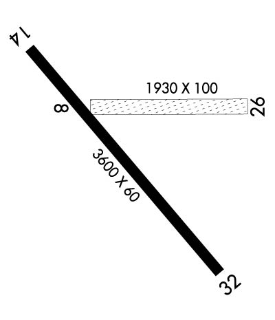
| Lat: N 4845.2 Long: W 09823.6 Elev: 1608 Var: -07 Longest Runway: 3600 | ||
| AWOS: 118.22 CTAF: 122.8 | ||
| ||||||||||||||||||||||||||||||||||||||||||||
| ||||||||||||||||||||||||||||||||||||||||||||
| ||||||||||||||||||||||||||||||||||||||||||||
| Rwy | Rwy | |||||||
| 1930x100 | 1930' | 1930x100 | 1930' | |||||
| 3600x60 | 3600' | 3600x60 | 3600' | |||||
| Runway ID | Single Wheel | Double Wheel | Double Tandem Wheel | Dual Double Wheel |
| 08/26 | N/A | N/A | N/A | N/A |
| 14/32 | 12,500 | N/A | N/A | N/A |
| These numbers are Advisory and are not limits. The Airport Manager should have more accurate Weight Limits | ||||
 Airport Diagram might not be current. | |
| Facility Name: | ROBERTSON FLD |
| City Name: | LANGDON |
| County: | CAVALIER |
| State abbrev: | ND |
| State Name: | NORTH DAKOTA |
| Ownership: | PUBLICLY OWNED |
| Use: | OPEN TO THE PUBLIC |
| Owner's Name: | LANGDON ARPT AUTHORITY |
| Address: | 1310 12TH ST |
| LANGDON, ND 58249 | |
| Owner's Phone: | 701-370-2076; JOHN BOE, CHAIRMAN OF ARPT AUTH, ADDNL PHONE 701-370-2076. |
| Manager's Name: | RYAN HOWATT |
| Address: | |
| LANGDON, ND 58249 | |
| Phone: | (701) 370-9710 |
| FAA Region: | GREAT LAKES |
| FAA Field Office: | DMA |
| Date | Sunrise | Sunset |
|---|---|---|
| 09/24/21 Friday | 7:23 | 19:28 |
| 09/25/21 Saturday | 7:24 | 19:25 |
| 09/26/21 Sunday | 7:26 | 19:23 |
| 09/27/21 Monday | 7:27 | 19:21 |
| 09/28/21 Tuesday | 7:28 | 19:19 |
| 09/29/21 Wednesday | 7:30 | 19:17 |
| 09/30/21 Thursday | 7:31 | 19:15 |
| 10/01/21 Friday | 7:33 | 19:13 |
| 10/02/21 Saturday | 7:34 | 19:11 |
| 10/03/21 Sunday | 7:36 | 19:09 |
| 10/04/21 Monday | 7:37 | 19:07 |
| 10/05/21 Tuesday | 7:39 | 19:05 |
| 10/06/21 Wednesday | 7:40 | 19:02 |
| 10/07/21 Thursday | 7:42 | 19:00 |
| Airport Attendance Schedule | 7 Days A Week ON CALL; FOR SVCS AFT HRS CTC AMGR 701-370-9710. |
| Airport Status | OPERATIONAL (This Status can change at any time - please check NOTAMS) |
| Airport Lighting Schedule | ACTVT PAPI RWY 14 & 32; MIRL RWY 14/32 - CTAF. |
| Airport Storage Available | Tie Downs, Hanger |
| Extra Services Available | Crop Dusting |
| Wind Indicator | YES - (lighted) |
| Control Tower | NO |
| CTAF Frequency | 122.800 |
| Unicom Frequency | 122.800 |
| Rotating Beacon Color | CLEAR-GREEN (Light Land Airport) |
| Segmented Circle | NO |
| Landing Fee | NO |
| Airport Inspected | STATE - performed by STATE AERONAUTICAL PERSONNEL |
| Inspection Date | 09/05/2019 |
| Type of Fuel Available | Grade 100LL; -10SELF SVC FUEL AVBL 24 HR WITH CREDIT CARD. |
| Airframe Repair Service | NONE |
| Power Plant Repair Service | NONE |
| Latitude | N4845.2 |
| Longitude | W09823.6 (ESTIMATED) |
| Arpt Elevation | 1608ft (SURVEYED) |
| Magnetic Variation | 07E |
| 1 miles WSW | of LANGDON |
| Traffic Pattern Altitude | |
| Sectional Chart | TWIN CITIES |
| Operations (Reported) | Yearly | Avg. Daily |
|---|---|---|
| General Aviation Transient | 1000 | 3 |
| General Aviation Local | 10000 | 27 |
| Air Taxi | 200 | 1 |
| Commerical | 0 | 0 |
| Commuter | 0 | 0 |
| Military | 50 | 0 |
| Aircraft based on Field | |
|---|---|
| General Aviation Singles | 20 |
| General Aviation Multi | 0 |
| Jet Aircraft | 0 |
| General Aviation Helicopters | 0 |
| Military Aircraft | 0 |
| Gliders | 0 |
| Ultralights | 0 |
| FSS on field | NO |
| FSS tie-in | GRAND FORKS |
| FSS Phone | 1-800-WX-BRIEF |
| Who issues Notams | GFK |
| Notam D service at airport | YES |
| ARTCC Name | MINNEAPOLIS |
| Airport Certification | |
| Aircraft Rescue & Firefighting Index | None |
| Airport of Entry | No |
| Custom Landing Rights | No |
| Joint Civil/Military | No |
| Military Landing rights | YES |
| NATIONAL PLAN OF INTEGRATED AIRPORT SYSTEMS (NPIAS) |
| GRANT AGREEMENTS UNDER FAAP/ADAP/AIP |
| ASSURANCES PURSUANT TO TITLE VI, CIVIL RIGHTS ACT OF 1964 |
| RY 08/26 CLOSED WINTERS DUE TO LACK OF SNOW REMOVAL. |
| LARGE BIRDS AND DEER ON & INVOF ARPT APR-NOV. |
| MIDFIELD N/S TWY IS CLDD INDEFLY DUE TO POOR CONDITION. |
| CFM WINTER CONDS/SNOW REMOVAL WITH AMGR 701-370-9710. |
| NOISE SENSITIVE AREA NW QUADRANT OF FIELD; AVOID OVERFLIGHT. |
| FOR CD CTC MINNEAPOLIS ARTCC AT 651-463-5588. |
| COLD TEMPERATURE AIRPORT. ALTITUDE CORRECTION REQUIRED AT OR BELOW -35C. |
Airport Communications & Frequencies:
| |||||||||
| Runway: 08 | Runway: 26 | ||
| Mag heading: | 82° | Mag heading: | 262° |
| Rwy Slope: | .03% Up | Rwy Slope: | -.03% Down |
| Approach: | Approach: | ||
| Pattern: | Left Traffic | Pattern: | Left Traffic |
| Markings: | NONE | Markings: | NONE |
| Marking Condition: | Marking Condition: | ||
| Arresting Dev: | Arresting Dev: | ||
| Lat & Long: | N4845.3 W09823.8 | Lat. & Long.: | N4845.3 W09823.3 |
| Elev: | 1600.5 ft. MSL | Elev: | 1601.0 ft. MSL |
| TCH: | TCH: | ||
| Visual Glide Path: | Visual Glide Path: | ||
| Displaced Threshold: | No | Displaced Threshold: | No |
| Touchdown Zone: | YES | Touchdown Zone: | YES |
| Touchdown Elev.: | 1601.5 feet | Touchdown Elev.: | 1601.5 feet |
| Visual Glide Slope: | Visual Glide Slope: | ||
| RVR Equipment: | RVR Equipment: | ||
| RVV Equipment: | NO | RVV Equipment: | NO |
| Approach Lights: | Approach Lights: | ||
| REIL: | NO | REIL: | NO |
| Centerline Lights: | NO | Centerline Lights: | NO |
| Touchdown lights: | NO | Touchdown lights: | NO |
| Runway Category: | Runway with a Visual Approach | Runway Category: | Runway with a Visual Approach |
| Declared Distances: | Declared Distances: | ||
| Obstructions: | Obstructions: | ROAD; +334 FT TWR 6550 FT FM THLD, 230 FT R OF EXTDD CNTRLN. | |
| Marked: | Marked: | NOT Marked/Lighted | |
| Clearance slope: | 20:1 | Clearance slope: | 18:1 |
| Obstruction height: | Obstruction height: | 14 feet AGL | |
| Dist. from runway: | Dist. from runway: | 265 feet | |
| Centerline offset: | Centerline offset: | ||
| Comments: | Comments: |
| Runway: 14 | Runway: 32 | ||
| Mag heading: | 132° | Mag heading: | 312° |
| Rwy Slope: | .15% Up | Rwy Slope: | -.15% Down |
| Approach: | Approach: | ||
| Pattern: | Left Traffic | Pattern: | Left Traffic |
| Markings: | NONPRECISION INSTRUMENT | Markings: | NONPRECISION INSTRUMENT |
| Marking Condition: | GOOD | Marking Condition: | GOOD |
| Arresting Dev: | Arresting Dev: | ||
| Lat & Long: | N4845.4 W09824.0 | Lat. & Long.: | N4844.9 W09823.4 |
| Elev: | 1602.9 ft. MSL | Elev: | 1608.4 ft. MSL |
| TCH: | 28 ft. AGL | TCH: | 27 ft. AGL |
| Visual Glide Path: | 3.00 degrees | Visual Glide Path: | 3.00 degrees |
| Displaced Threshold: | No | Displaced Threshold: | No |
| Touchdown Zone: | YES | Touchdown Zone: | YES |
| Touchdown Elev.: | 1605.7 feet | Touchdown Elev.: | 1608.4 feet |
| Visual Glide Slope: | 2-Light PAPI on LEFT side of Runway | Visual Glide Slope: | 2-Light PAPI on LEFT side of Runway |
| RVR Equipment: | RVR Equipment: | ||
| RVV Equipment: | NO | RVV Equipment: | NO |
| Approach Lights: | Approach Lights: | ||
| REIL: | NO | REIL: | NO |
| Centerline Lights: | NO | Centerline Lights: | NO |
| Touchdown lights: | NO | Touchdown lights: | NO |
| Runway Category: | Runway with a Non-precision Approach | Runway Category: | Runway with a Non-precision Approach |
| Declared Distances: | Declared Distances: |
Thanks for using FltPlan.com
all rights reserved © 1999-2021 by Flight Plan LLC
