
| CROSBY MUNI CROSBY ND |
| |
| Lat: N 4855.7 Long: W 10317.9 Elev: 1953 Var: -07 Longest Runway: 3800 | ||
| AWOS: 118.02 CTAF: 122.9 | ||
| ||||||
| ||||||
|
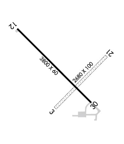
| Rwy | Rwy | |||||||
| 2680x100 | 2680' | 2680x100 | 2680' | |||||
| 3800x75 | 3800' | 3800x75 | 3800' | |||||
| Runway ID | Single Wheel | Double Wheel | Double Tandem Wheel | Dual Double Wheel |
| 03/21 | N/A | N/A | N/A | N/A |
| 13/31 | 12,500 | N/A | N/A | N/A |
| These numbers are Advisory and are not limits. The Airport Manager should have more accurate Weight Limits | ||||
 Airport Diagram might not be current. | |
| Facility Name: | CROSBY MUNI |
| City Name: | CROSBY |
| County: | DIVIDE |
| State abbrev: | ND |
| State Name: | NORTH DAKOTA |
| Ownership: | PUBLICLY OWNED |
| Use: | OPEN TO THE PUBLIC |
| Owner's Name: | CROSBY ARPT AUTH |
| Address: | PO BOX 882 |
| CROSBY, ND 58730 | |
| Owner's Phone: | (701) 570-0944 |
| Manager's Name: | MIKE MELBY; ARPT MAINT & SNOW RMVL CTC PERSON. |
| Address: | PO BOX 154 |
| CROSBY, ND 58730 | |
| Phone: | 701-570-0944; HOME PHONE 701-965-4284; ADNL CTC NEIL BENTER 701-641-8554, 701-965-6512, OR 701-965-6775. |
| FAA Region: | GREAT LAKES |
| FAA Field Office: | DMA |
| Date | Sunrise | Sunset |
|---|---|---|
| 06/08/26 Monday | 5:50 | 21:55 |
| 06/09/26 Tuesday | 5:50 | 21:55 |
| 06/10/26 Wednesday | 5:50 | 21:56 |
| 06/11/26 Thursday | 5:49 | 21:57 |
| 06/12/26 Friday | 5:49 | 21:57 |
| 06/13/26 Saturday | 5:49 | 21:58 |
| 06/14/26 Sunday | 5:49 | 21:58 |
| 06/15/26 Monday | 5:49 | 21:59 |
| 06/16/26 Tuesday | 5:49 | 21:59 |
| 06/17/26 Wednesday | 5:49 | 22:00 |
| 06/18/26 Thursday | 5:49 | 22:00 |
| 06/19/26 Friday | 5:49 | 22:00 |
| 06/20/26 Saturday | 5:49 | 22:01 |
| 06/21/26 Sunday | 5:49 | 22:01 |
| Airport Attendance Schedule | UNATTENDED |
| Airport Status | OPERATIONAL (This Status can change at any time - please check NOTAMS) |
| Airport Lighting Schedule | PAPI RWY 13 & 31 OPER DUSK-0100. MIRL RWY 13/31 PRESET ON LOW INTST DUSK-0100; TO INCR INTST ACTVT - CTAF. AFT 0100 ACTVT MIRL RWY 13/31; PAPI RWY 13 & 31 - CTAF. |
| Airport Storage Available | Tie Downs |
| Extra Services Available | Crop Dusting |
| Wind Indicator | YES - (lighted) |
| Control Tower | NO |
| CTAF Frequency | 122.900 |
| Unicom Frequency | |
| Rotating Beacon Color | WG |
| Segmented Circle | YES |
| Landing Fee | NO |
| Airport Inspected | STATE - performed by STATE AERONAUTICAL PERSONNEL |
| Inspection Date | 08/15/2024 |
| Type of Fuel Available | Grade 100LL; -10SELF SVC FUEL AVBL H24 VIA CREDIT CARD. |
| Airframe Repair Service | NONE |
| Power Plant Repair Service | NONE |
| Latitude | N4855.7 |
| Longitude | W10317.9 (ESTIMATED) |
| Arpt Elevation | 1952ft (SURVEYED) |
| Magnetic Variation | 07E |
| 1 miles N | of CROSBY |
| Traffic Pattern Altitude | |
| Sectional Chart | BILLINGS |
| Operations (Reported) | Yearly | Avg. Daily |
|---|---|---|
| General Aviation Transient | 0 | 0 |
| General Aviation Local | 0 | 0 |
| Air Taxi | 0 | 0 |
| Commerical | 0 | 0 |
| Commuter | 0 | 0 |
| Military | 0 | 0 |
| Aircraft based on Field | |
|---|---|
| General Aviation Singles | 0 |
| General Aviation Multi | 0 |
| Jet Aircraft | 0 |
| General Aviation Helicopters | 0 |
| Military Aircraft | 0 |
| Gliders | 0 |
| Ultralights | 0 |
| FSS on field | NO |
| FSS tie-in | GRAND FORKS |
| FSS Phone | 1-800-WX-BRIEF |
| Who issues Notams | GFK |
| Notam D service at airport | YES |
| ARTCC Name | SALT LAKE CITY |
| Airport Certification | |
| Aircraft Rescue & Firefighting Index | None |
| Airport of Entry | No |
| Custom Landing Rights | No |
| Joint Civil/Military | No |
| Military Landing rights | YES |
| NATIONAL PLAN OF INTEGRATED AIRPORT SYSTEMS (NPIAS) |
| GRANT AGREEMENTS UNDER FAAP/ADAP/AIP |
| ASSURANCES PURSUANT TO TITLE VI, CIVIL RIGHTS ACT OF 1964 |
| +250' TOWER 4000' SOUTH OF ARPT. |
| DEER AND BIRDS ON & INVOF ARPT. |
| FOR CD CTC SALT LAKE ARTCC AT 801-320-2568. |
| RWY 03/2 1 CLSD WINTER MONTHS DUE TO LACK OF SNOW REMOVAL. |
Airport Communications & Frequencies:
| |||||||
| Runway: 03 | Runway: 21 | ||
| Mag heading: | 38° | Mag heading: | 218° |
| Rwy Slope: | -.28% Down | Rwy Slope: | .28% Up |
| Approach: | Approach: | ||
| Pattern: | Left Traffic | Pattern: | Left Traffic |
| Markings: | NONPRECISION INSTRUMENT | Markings: | NONPRECISION INSTRUMENT |
| Marking Condition: | GOOD | Marking Condition: | GOOD |
| Arresting Dev: | Arresting Dev: | ||
| Lat & Long: | N4855.5 W10318.0 | Lat. & Long.: | N4855.8 W10317.5 |
| Elev: | 1949.2 ft. MSL | Elev: | 1941.6 ft. MSL |
| TCH: | TCH: | ||
| Visual Glide Path: | Visual Glide Path: | ||
| Displaced Threshold: | No | Displaced Threshold: | No |
| Touchdown Zone: | YES | Touchdown Zone: | YES |
| Touchdown Elev.: | 1951.4 feet | Touchdown Elev.: | 1951.4 feet |
| Visual Glide Slope: | Visual Glide Slope: | ||
| RVR Equipment: | RVR Equipment: | ||
| RVV Equipment: | NO | RVV Equipment: | NO |
| Approach Lights: | Approach Lights: | ||
| REIL: | NO | REIL: | NO |
| Centerline Lights: | NO | Centerline Lights: | NO |
| Touchdown lights: | NO | Touchdown lights: | NO |
| Runway Category: | Runway with a Visual Approach | Runway Category: | Runway with a Visual Approach |
| Declared Distances: | Declared Distances: |
| Runway: 13 | Runway: 31 | ||
| Mag heading: | 127° | Mag heading: | 307° |
| Rwy Slope: | -.16% Down | Rwy Slope: | .16% Up |
| Approach: | Approach: | ||
| Pattern: | Left Traffic | Pattern: | Left Traffic |
| Markings: | NONPRECISION INSTRUMENT | Markings: | NONPRECISION INSTRUMENT |
| Marking Condition: | GOOD | Marking Condition: | GOOD |
| Arresting Dev: | Arresting Dev: | ||
| Lat & Long: | N4856.0 W10318.3 | Lat. & Long.: | N4855.5 W10317.6 |
| Elev: | 1952.6 ft. MSL | Elev: | 1946.4 ft. MSL |
| TCH: | 33 ft. AGL | TCH: | 33 ft. AGL |
| Visual Glide Path: | 3.00 degrees | Visual Glide Path: | 3.00 degrees |
| Displaced Threshold: | No | Displaced Threshold: | No |
| Touchdown Zone: | YES | Touchdown Zone: | YES |
| Touchdown Elev.: | 1952.7 feet | Touchdown Elev.: | 1950.8 feet |
| Visual Glide Slope: | 2-Light PAPI on LEFT side of Runway | Visual Glide Slope: | 2-Light PAPI on LEFT side of Runway |
| RVR Equipment: | RVR Equipment: | ||
| RVV Equipment: | NO | RVV Equipment: | NO |
| Approach Lights: | Approach Lights: | ||
| REIL: | NO | REIL: | NO |
| Centerline Lights: | NO | Centerline Lights: | NO |
| Touchdown lights: | NO | Touchdown lights: | NO |
| Runway Category: | Runway with a Visual Approach | Runway Category: | Runway with a Non-precision Approach |
| Declared Distances: | Declared Distances: | ||
| Obstructions: | PLINE 33 FT ABV RWY END, 2,100 FT FM THLD, 395 FT L & R OF CNTRLN. | Obstructions: | |
| Marked: | NOT Marked/Lighted | Marked: | |
| Clearance slope: | 20:1 | Clearance slope: | 20:1 |
| Obstruction height: | Obstruction height: | ||
| Dist. from runway: | Dist. from runway: | ||
| Centerline offset: | Centerline offset: | ||
| Comments: | Comments: |
Thanks for using FltPlan.com
all rights reserved © 1999-2026 by Flight Plan LLC
