
| CANANDAIGUA CANANDAIGUA NY |
| |
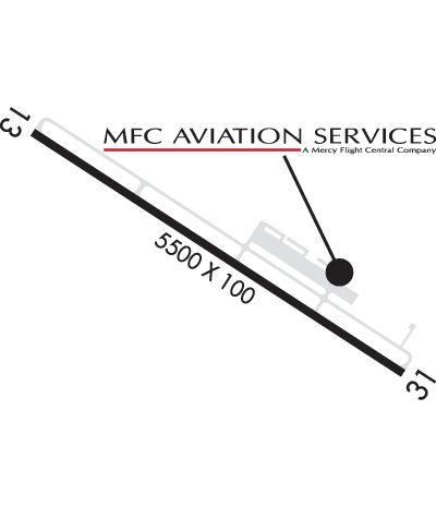
| Lat: N 4254.5 Long: W 07719.5 Elev: 814 Var: +12 Longest Runway: 5500 | ||
| Clr Del: 888-766-8267 AWOS: 118.67 CTAF: 122.8 | ||
| ||||||||||||||||||||||||||||||||||||||||||||||||||||||||||||||
| ||||||||||||||||||||||||||||||||||||||||||||||||||||||||||||||
| ||||||||||||||||||||||||||||||||||||||||||||||||||||||||||||||
| Rwy | Rwy | |||||||
| 5500x100 | 5500' | 5500x100 | 5500' | |||||
| Runway ID | Single Wheel | Double Wheel | Double Tandem Wheel | Dual Double Wheel |
| 13/31 | N/A | N/A | N/A | N/A |
| These numbers are Advisory and are not limits. The Airport Manager should have more accurate Weight Limits | ||||
 Airport Diagram might not be current. | |
| Facility Name: | CANANDAIGUA |
| City Name: | CANANDAIGUA |
| County: | ONTARIO |
| State abbrev: | NY |
| State Name: | NEW YORK |
| Ownership: | PUBLICLY OWNED |
| Use: | OPEN TO THE PUBLIC |
| Owner's Name: | ONTARIO COUNTY IDA |
| Address: | 20 ONTARIO ST |
| CANANDAIGUA, NY 14425 | |
| Owner's Phone: | 585-396-4460 |
| Manager's Name: | JIM DOLAN |
| Address: | 2525 SR 332, BOX 6, STE 101 |
| CANANDAIGUA, NY 14424 | |
| Phone: | 315-243-7428 |
| FAA Region: | EASTERN |
| FAA Field Office: | NYC |
| Date | Sunrise | Sunset |
|---|---|---|
| 11/04/17 Saturday | 7:47 | 17:58 |
| 11/05/17 Sunday | 6:48 | 16:57 |
| 11/06/17 Monday | 6:50 | 16:56 |
| 11/07/17 Tuesday | 6:51 | 16:54 |
| 11/08/17 Wednesday | 6:52 | 16:53 |
| 11/09/17 Thursday | 6:54 | 16:52 |
| 11/10/17 Friday | 6:55 | 16:51 |
| 11/11/17 Saturday | 6:56 | 16:50 |
| 11/12/17 Sunday | 6:57 | 16:49 |
| 11/13/17 Monday | 6:59 | 16:48 |
| 11/14/17 Tuesday | 7:00 | 16:47 |
| 11/15/17 Wednesday | 7:01 | 16:46 |
| 11/16/17 Thursday | 7:02 | 16:45 |
| 11/17/17 Friday | 7:04 | 16:44 |
| Airport Attendance Schedule | CONTINUOUS |
| Airport Status | OPERATIONAL (This Status can change at any time - please check NOTAMS) |
| Airport Lighting Schedule | ACTIVATE MIRL RY 13/31 - CTAF. |
| Airport Storage Available | Tie Downs, Hanger |
| Extra Services Available | Flight Instruction, Aircraft Rental |
| Wind Indicator | YES - (lighted) |
| Control Tower | NO |
| CTAF Frequency | 122.800 |
| Unicom Frequency | 122.800 |
| Rotating Beacon Color | CLEAR-GREEN (Light Land Airport) |
| Segmented Circle | YES |
| Landing Fee | NO |
| Airport Inspected | STATE - performed by STATE AERONAUTICAL PERSONNEL |
| Inspection Date | 06/20/2014 |
| Type of Fuel Available | Grade 100LL, JET A |
| Airframe Repair Service | MAJOR |
| Power Plant Repair Service | MAJOR |
| Latitude | N4254.5 |
| Longitude | W07719.5 (ESTIMATED) |
| Arpt Elevation | 813ft (SURVEYED) |
| Magnetic Variation | 12W |
| 3 miles NW | of CANANDAIGUA |
| Traffic Pattern Altitude | |
| Sectional Chart | DETROIT |
| Operations (Reported) | Yearly | Avg. Daily |
|---|---|---|
| General Aviation Transient | 10260 | 28 |
| General Aviation Local | 10260 | 28 |
| Air Taxi | 1080 | 3 |
| Commerical | 0 | 0 |
| Commuter | 0 | 0 |
| Military | 0 | 0 |
| Aircraft based on Field | |
|---|---|
| General Aviation Singles | 29 |
| General Aviation Multi | 2 |
| Jet Aircraft | 0 |
| General Aviation Helicopters | 0 |
| Military Aircraft | 0 |
| Gliders | 0 |
| Ultralights | 3 |
| FSS on field | NO |
| FSS tie-in | BUFFALO |
| FSS Phone | 1-800-WX-BRIEF |
| Who issues Notams | BUF |
| Notam D service at airport | YES |
| ARTCC Name | CLEVELAND |
| Airport Certification | |
| Aircraft Rescue & Firefighting Index | None |
| Airport of Entry | No |
| Custom Landing Rights | No |
| Joint Civil/Military | No |
| Military Landing rights | No |
| NATIONAL PLAN OF INTEGRATED AIRPORT SYSTEMS (NPIAS) |
| FOR SVCS AND ARPT CONDITIONS CALL 585-394-4780. |
| FREQUENT MEDIVAC HELICOPTER OPERATIONS MONITOR CTAF. |
Airport Communications & Frequencies:
| |||||||||||||||||
| Runway: 13 | Runway: 31 | ||
| Mag heading: | 135° | Mag heading: | 315° |
| Rwy Slope: | .42% Up | Rwy Slope: | -.42% Down |
| Approach: | Approach: | ||
| Pattern: | Left Traffic | Pattern: | Left Traffic |
| Markings: | NONPRECISION INSTRUMENT | Markings: | NONPRECISION INSTRUMENT |
| Marking Condition: | GOOD | Marking Condition: | GOOD |
| Arresting Dev: | Arresting Dev: | ||
| Lat & Long: | N4254.8 W07720.0 | Lat. & Long.: | N4254.3 W07719.0 |
| Elev: | 788.6 ft. MSL | Elev: | 811.9 ft. MSL |
| TCH: | 40 ft. AGL | TCH: | 40 ft. AGL |
| Visual Glide Path: | 3.00 degrees | Visual Glide Path: | 3.00 degrees |
| Displaced Threshold: | No | Displaced Threshold: | No |
| Touchdown Zone: | YES | Touchdown Zone: | YES |
| Touchdown Elev.: | 803.6 feet | Touchdown Elev.: | 813.6 feet |
| Visual Glide Slope: | 2-Light PAPI on LEFT side of Runway | Visual Glide Slope: | 2-Light PAPI on LEFT side of Runway |
| RVR Equipment: | RVR Equipment: | ||
| RVV Equipment: | NO | RVV Equipment: | NO |
| Approach Lights: | Approach Lights: | ||
| REIL: | YES | REIL: | YES |
| Centerline Lights: | NO | Centerline Lights: | NO |
| Touchdown lights: | NO | Touchdown lights: | NO |
| Runway Category: | Runway with a Non-precision Approach having visibility minimums greater than 3/4 mile | Runway Category: | Runway with a Non-precision Approach having visibility minimums greater than 3/4 mile |
| Declared Distances: | Declared Distances: | ||
| Obstructions: | TREE | Obstructions: | TREE |
| Marked: | NOT Marked/Lighted | Marked: | NOT Marked/Lighted |
| Clearance slope: | 24:1 | Clearance slope: | 22:1 |
| Obstruction height: | 46 feet AGL | Obstruction height: | 38 feet AGL |
| Dist. from runway: | 1324 feet | Dist. from runway: | 1069 feet |
| Centerline offset: | 233 right of centerline | Centerline offset: | 131 feet right of centerline |
| Comments: | Comments: | 9 FT BUSH/FENCE 176 FT FM THRESHOLD 243 FT 'L'. |
Thanks for using FltPlan.com
all rights reserved © 1999-2017 by Flight Plan LLC