
| WARREN MUNI WARREN MN |
| |
| Lat: N 4811.5 Long: W 09642.7 Elev: 888 Var: -05 Longest Runway: 3199 | ||
| CTAF: 122.8 | ||
| ||||||||||||||||||||||||||||||||
| ||||||||||||||||||||||||||||||||
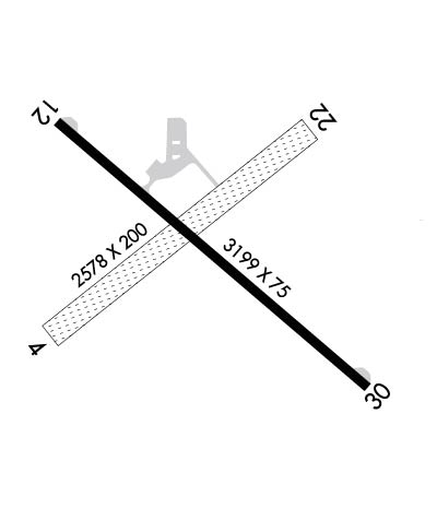
| Rwy | Rwy | |||||||
| 2578x200 | 2578' | 2578x200 | 2578' | |||||
| 3199x75 | 3009' | 3199x75 | 3199' | |||||
| Runway ID | Single Wheel | Double Wheel | Double Tandem Wheel | Dual Double Wheel |
| 04/22 | N/A | N/A | N/A | N/A |
| 12/30 | 26,000 | N/A | N/A | N/A |
| These numbers are Advisory and are not limits. The Airport Manager should have more accurate Weight Limits | ||||
 Airport Diagram might not be current. | |
| Facility Name: | WARREN MUNI |
| City Name: | WARREN |
| County: | MARSHALL |
| State abbrev: | MN |
| State Name: | MINNESOTA |
| Ownership: | PUBLICLY OWNED |
| Use: | OPEN TO THE PUBLIC |
| Owner's Name: | CITY OF WARREN |
| Address: | 120 E BRIDGE AVE |
| WARREN, MN 56762 | |
| Owner's Phone: | 218-745-5343 |
| Manager's Name: | AARON PETERSON |
| Address: | 120 E. BRIDGE AVE. |
| WARREN, MN 56762 | |
| Phone: | (218) 201-0652; USE TEXT MSGG WHEN CTCG ARPT MGR. |
| FAA Region: | GREAT LAKES |
| FAA Field Office: | DMA |
| Date | Sunrise | Sunset |
|---|---|---|
| 06/12/26 Friday | 5:26 | 21:27 |
| 06/13/26 Saturday | 5:26 | 21:28 |
| 06/14/26 Sunday | 5:26 | 21:28 |
| 06/15/26 Monday | 5:26 | 21:29 |
| 06/16/26 Tuesday | 5:26 | 21:29 |
| 06/17/26 Wednesday | 5:26 | 21:30 |
| 06/18/26 Thursday | 5:26 | 21:30 |
| 06/19/26 Friday | 5:26 | 21:30 |
| 06/20/26 Saturday | 5:26 | 21:31 |
| 06/21/26 Sunday | 5:26 | 21:31 |
| 06/22/26 Monday | 5:26 | 21:31 |
| 06/23/26 Tuesday | 5:27 | 21:31 |
| 06/24/26 Wednesday | 5:27 | 21:31 |
| 06/25/26 Thursday | 5:27 | 21:31 |
| Airport Attendance Schedule | MAY-OCT SAT-SUN 0800-1700 |
| Airport Status | OPERATIONAL (This Status can change at any time - please check NOTAMS) |
| Airport Lighting Schedule | SS-SR |
| Airport Storage Available | Tie Downs, Hanger |
| Extra Services Available | Crop Dusting, Aircraft Sales |
| Wind Indicator | YES - (lighted) |
| Control Tower | NO |
| CTAF Frequency | 122.800 |
| Unicom Frequency | 122.800 |
| Rotating Beacon Color | WG |
| Segmented Circle | NO |
| Landing Fee | NO |
| Airport Inspected | STATE - performed by STATE AERONAUTICAL PERSONNEL |
| Inspection Date | 07/02/2024 |
| Type of Fuel Available | None |
| Airframe Repair Service | None |
| Power Plant Repair Service | None |
| Latitude | N4811.5 |
| Longitude | W09642.7 (ESTIMATED) |
| Arpt Elevation | 888ft (SURVEYED) |
| Magnetic Variation | 05E |
| 2 miles E | of WARREN |
| Traffic Pattern Altitude | |
| Sectional Chart | TWIN CITIES |
| Operations (Reported) | Yearly | Avg. Daily |
|---|---|---|
| General Aviation Transient | 0 | 0 |
| General Aviation Local | 0 | 0 |
| Air Taxi | 0 | 0 |
| Commerical | 0 | 0 |
| Commuter | 0 | 0 |
| Military | 0 | 0 |
| Aircraft based on Field | |
|---|---|
| General Aviation Singles | 0 |
| General Aviation Multi | 0 |
| Jet Aircraft | 0 |
| General Aviation Helicopters | 0 |
| Military Aircraft | 0 |
| Gliders | 0 |
| Ultralights | 0 |
| FSS on field | NO |
| FSS tie-in | PRINCETON |
| FSS Phone | 1-800-WX-BRIEF |
| Who issues Notams | PNM |
| Notam D service at airport | YES |
| ARTCC Name | MINNEAPOLIS |
| Airport Certification | |
| Aircraft Rescue & Firefighting Index | None |
| Airport of Entry | No |
| Custom Landing Rights | No |
| Joint Civil/Military | No |
| Military Landing rights | YES |
| ASSURANCES PURSUANT TO TITLE VI, CIVIL RIGHTS ACT OF 1964 |
| GRANT AGREEMENT HAS EXPIRED; HOWEVER, AGREEMENT REMAINS IN EFFECT FOR THIS FACILITY AS LONG AS IT IS PUBLIC USE. |
| DEER & GEESE ON & INVOF ARPT. |
| TOWER 4 'WNW', 1248 FT MSL (400 FT AGL). |
| FOR CD CTC MINNEAPOLIS ARTCC AT 651-463-5588. |
| RWY 04/2 2 MARKED WITH YELLOW CONES. NOT PLOWED WINTER MONTHS. |
| RWY 30 CALM WND RWY. |
Airport Communications & Frequencies:
| |||||||||||||||||
| Runway: 04 | Runway: 22 | ||
| Mag heading: | 43° | Mag heading: | 223° |
| Rwy Slope: | -.05% Down | Rwy Slope: | .05% Up |
| Approach: | Approach: | ||
| Pattern: | Left Traffic | Pattern: | Left Traffic |
| Markings: | NONSTANDARD | Markings: | NONSTANDARD |
| Marking Condition: | FAIR; MKD WITH YELLOW CONES. | Marking Condition: | FAIR; MKD WITH YELLOW CONES. |
| Arresting Dev: | Arresting Dev: | ||
| Lat & Long: | N4811.3 W09643.0 | Lat. & Long.: | N4811.6 W09642.5 |
| Elev: | 886.2 ft. MSL | Elev: | 884.9 ft. MSL |
| TCH: | TCH: | ||
| Visual Glide Path: | Visual Glide Path: | ||
| Displaced Threshold: | No | Displaced Threshold: | No |
| Touchdown Zone: | YES | Touchdown Zone: | YES |
| Touchdown Elev.: | 886.2 feet | Touchdown Elev.: | 886.2 feet |
| Visual Glide Slope: | Visual Glide Slope: | ||
| RVR Equipment: | RVR Equipment: | ||
| RVV Equipment: | NO | RVV Equipment: | NO |
| Approach Lights: | Approach Lights: | ||
| REIL: | NO | REIL: | NO |
| Centerline Lights: | NO | Centerline Lights: | NO |
| Touchdown lights: | NO | Touchdown lights: | NO |
| Runway Category: | Runway with a Visual Approach | Runway Category: | Runway with a Visual Approach |
| Declared Distances: | Declared Distances: |
| Runway: 12 | Runway: 30 | ||
| Mag heading: | 125° | Mag heading: | 305° |
| Rwy Slope: | -.06% Down | Rwy Slope: | .06% Up |
| Approach: | Approach: | ||
| Pattern: | Left Traffic | Pattern: | Left Traffic |
| Markings: | NONPRECISION INSTRUMENT | Markings: | NONPRECISION INSTRUMENT |
| Marking Condition: | GOOD | Marking Condition: | GOOD |
| Arresting Dev: | Arresting Dev: | ||
| Lat & Long: | N4811.6 W09642.9 | Lat. & Long.: | N4811.3 W09642.3 |
| Elev: | 887.2 ft. MSL | Elev: | 885.4 ft. MSL |
| TCH: | TCH: | ||
| Visual Glide Path: | Visual Glide Path: | ||
| Displaced Threshold: | 190 feet | Displaced Threshold: | No |
| Touchdown Zone: | YES | Touchdown Zone: | YES |
| Touchdown Elev.: | 888.2 feet | Touchdown Elev.: | 888.2 feet |
| Visual Glide Slope: | Visual Glide Slope: | ||
| RVR Equipment: | RVR Equipment: | ||
| RVV Equipment: | NO | RVV Equipment: | NO |
| Approach Lights: | Approach Lights: | ||
| REIL: | NO | REIL: | NO |
| Centerline Lights: | NO | Centerline Lights: | NO |
| Touchdown lights: | NO | Touchdown lights: | NO |
| Runway Category: | Runway with a Visual Approach | Runway Category: | Runway with a Non-precision Approach having visibility minimums greater than 3/4 mile |
| Declared Distances: | TORA:3199' TODA:3199' ASDA:3199' LDA:3009' | Declared Distances: | TORA:3199' TODA:3199' ASDA:3199' LDA:3199' |
| Obstructions: | ROAD | Obstructions: | |
| Marked: | NOT Marked/Lighted | Marked: | |
| Clearance slope: | 17:1 | Clearance slope: | 34:1 |
| Obstruction height: | 18 feet AGL | Obstruction height: | |
| Dist. from runway: | 507 feet | Dist. from runway: | |
| Centerline offset: | 266 left of centerline | Centerline offset: | |
| Comments: | Comments: |
Thanks for using FltPlan.com
all rights reserved © 1999-2026 by Flight Plan LLC
