
| LEEDS MUNI LEEDS ND |
| |
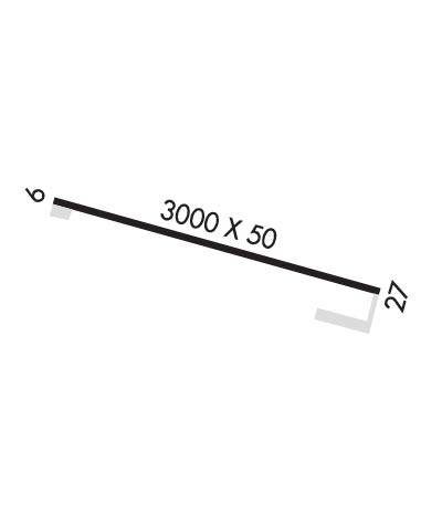
| Lat: N 4817.1 Long: W 09924.1 Elev: 1508 Var: -09 Longest Runway: 3000 | ||
| CTAF: 122.8 | ||
| ||||||||||||||||||||||||||||||||
| ||||||||||||||||||||||||||||||||
| Rwy | Rwy | |||||||
| 3000x50 | 3000' | 3000x50 | 3000' | |||||
| Runway ID | Single Wheel | Double Wheel | Double Tandem Wheel | Dual Double Wheel |
| 09/27 | 7,000 | N/A | N/A | N/A |
| These numbers are Advisory and are not limits. The Airport Manager should have more accurate Weight Limits | ||||
| FltPlan does not have IFR approach charts available for KD31. |
 Airport Diagram might not be current. | |
| Facility Name: | LEEDS MUNI |
| City Name: | LEEDS |
| County: | BENSON |
| State abbrev: | ND |
| State Name: | NORTH DAKOTA |
| Ownership: | PUBLICLY OWNED |
| Use: | OPEN TO THE PUBLIC |
| Owner's Name: | LEEDS MUNICIPAL AIRPORT AUTHORITY; ERIKA KENNER, CHAIR OF ARPT AUTH |
| Address: | 440 6TH AVE SE |
| LEEDS, ND 58346 | |
| Owner's Phone: | (406) 581-1188 |
| Manager's Name: | ERIKA KENNER |
| Address: | 440 6TH AVE SE |
| LEEDS, ND 58346 | |
| Phone: | 406-581-1188 |
| FAA Region: | GREAT LAKES |
| FAA Field Office: | DMA |
| Date | Sunrise | Sunset |
|---|---|---|
| 06/08/26 Monday | 5:38 | 21:36 |
| 06/09/26 Tuesday | 5:37 | 21:37 |
| 06/10/26 Wednesday | 5:37 | 21:37 |
| 06/11/26 Thursday | 5:37 | 21:38 |
| 06/12/26 Friday | 5:36 | 21:39 |
| 06/13/26 Saturday | 5:36 | 21:39 |
| 06/14/26 Sunday | 5:36 | 21:40 |
| 06/15/26 Monday | 5:36 | 21:40 |
| 06/16/26 Tuesday | 5:36 | 21:41 |
| 06/17/26 Wednesday | 5:36 | 21:41 |
| 06/18/26 Thursday | 5:36 | 21:41 |
| 06/19/26 Friday | 5:36 | 21:42 |
| 06/20/26 Saturday | 5:36 | 21:42 |
| 06/21/26 Sunday | 5:37 | 21:42 |
| Airport Attendance Schedule | UNATTENDED |
| Airport Status | OPERATIONAL (This Status can change at any time - please check NOTAMS) |
| Airport Lighting Schedule | SS-SR |
| Airport Storage Available | NONE |
| Extra Services Available | Crop Dusting |
| Wind Indicator | YES - (unlit) |
| Control Tower | NO |
| CTAF Frequency | 122.800 |
| Unicom Frequency | 122.800 |
| Rotating Beacon Color | |
| Segmented Circle | YES |
| Landing Fee |
| Airport Inspected | STATE - performed by STATE AERONAUTICAL PERSONNEL |
| Inspection Date | 08/30/2024 |
| Type of Fuel Available | None |
| Airframe Repair Service | NONE |
| Power Plant Repair Service | NONE |
| Latitude | N4817.1 |
| Longitude | W09924.1 (ESTIMATED) |
| Arpt Elevation | 1508ft (SURVEYED) |
| Magnetic Variation | 09E |
| 2 miles E | of LEEDS |
| Traffic Pattern Altitude | |
| Sectional Chart | TWIN CITIES |
| Operations (Reported) | Yearly | Avg. Daily |
|---|---|---|
| General Aviation Transient | 0 | 0 |
| General Aviation Local | 0 | 0 |
| Air Taxi | 0 | 0 |
| Commerical | 0 | 0 |
| Commuter | 0 | 0 |
| Military | 0 | 0 |
| Aircraft based on Field | |
|---|---|
| General Aviation Singles | 0 |
| General Aviation Multi | 0 |
| Jet Aircraft | 0 |
| General Aviation Helicopters | 0 |
| Military Aircraft | 0 |
| Gliders | 0 |
| Ultralights | 0 |
| FSS on field | NO |
| FSS tie-in | GRAND FORKS |
| FSS Phone | 1-800-WX-BRIEF |
| Who issues Notams | GFK |
| Notam D service at airport | YES |
| ARTCC Name | MINNEAPOLIS |
| Airport Certification | |
| Aircraft Rescue & Firefighting Index | None |
| Airport of Entry | No |
| Custom Landing Rights | No |
| Joint Civil/Military | No |
| Military Landing rights | No |
| CFM WINTER CONDS & SNOW REMOVAL CALL 406-581-1188. |
| MIGRATORY WATERFOWL ON AND INVOF ARPT. |
| RY 27 SAFETY AREA 200 FT OUT IS ROUGH WITH CLUMPY GRASS. |
| FOR CD CTC MINNEAPOLIS ARTCC AT 651-463-5588. |
| RWY 09/2 7 RWY 9/27 NSTD SOLAR LIGHTS. |
| Runway: 09 | Runway: 27 | ||
| Mag heading: | N/A | Mag heading: | N/A |
| Rwy Slope: | .00% | Rwy Slope: | .00% |
| Approach: | Approach: | ||
| Pattern: | Left Traffic | Pattern: | Left Traffic |
| Markings: | BASIC | Markings: | BASIC |
| Marking Condition: | GOOD | Marking Condition: | GOOD |
| Arresting Dev: | Arresting Dev: | ||
| Lat & Long: | N4817.1 W09924.5 | Lat. & Long.: | N4817.1 W09923.8 |
| Elev: | 1500.0 ft. MSL | Elev: | 1500.0 ft. MSL |
| TCH: | TCH: | ||
| Visual Glide Path: | Visual Glide Path: | ||
| Displaced Threshold: | No | Displaced Threshold: | No |
| Touchdown Zone: | NO | Touchdown Zone: | NO |
| Touchdown Elev.: | Touchdown Elev.: | ||
| Visual Glide Slope: | Visual Glide Slope: | ||
| RVR Equipment: | RVR Equipment: | ||
| RVV Equipment: | NO | RVV Equipment: | NO |
| Approach Lights: | Approach Lights: | ||
| REIL: | NO | REIL: | NO |
| Centerline Lights: | NO | Centerline Lights: | NO |
| Touchdown lights: | NO | Touchdown lights: | NO |
| Runway Category: | Runway with a Visual Approach | Runway Category: | Runway with a Visual Approach |
| Declared Distances: | Declared Distances: | ||
| Obstructions: | Obstructions: | ROAD | |
| Marked: | Marked: | NOT Marked/Lighted | |
| Clearance slope: | 20:1 | Clearance slope: | 9:1 |
| Obstruction height: | Obstruction height: | 13 feet AGL | |
| Dist. from runway: | Dist. from runway: | 320 feet | |
| Centerline offset: | Centerline offset: | 150B | |
| Comments: | Comments: |
Thanks for using FltPlan.com
all rights reserved © 1999-2026 by Flight Plan LLC
