
| BOTTINEAU MUNI BOTTINEAU ND |
| |
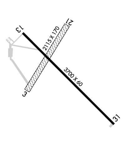
| Lat: N 4849.8 Long: W 10025.0 Elev: 1680 Var: -08 Longest Runway: 3700 | ||
| CTAF: 122.8 | ||
| ||||||||||||||||||||||||||||||||||||||||||||
| ||||||||||||||||||||||||||||||||||||||||||||
| Rwy | Rwy | |||||||
| 2115x170 | 2115' | 2115x170 | 2115' | |||||
| 3700x60 | 3700' | 3700x60 | 3700' | |||||
| Runway ID | Single Wheel | Double Wheel | Double Tandem Wheel | Dual Double Wheel |
| 03/21 | N/A | N/A | N/A | N/A |
| 13/31 | 12,500 | N/A | N/A | N/A |
| These numbers are Advisory and are not limits. The Airport Manager should have more accurate Weight Limits | ||||
 Airport Diagram might not be current. | |
| Facility Name: | BOTTINEAU MUNI |
| City Name: | BOTTINEAU |
| County: | BOTTINEAU |
| State abbrev: | ND |
| State Name: | NORTH DAKOTA |
| Ownership: | PUBLICLY OWNED |
| Use: | OPEN TO THE PUBLIC |
| Owner's Name: | BOTTINEAU AIRPORT AUTH |
| Address: | 9770 13TH AVE NE |
| BOTTINEAU, ND 58318 | |
| Owner's Phone: | (701) 228-2983; LEO JOSTAD, APT AUTHORITY CHAIRMAN. |
| Manager's Name: | LEO JOSTAD |
| Address: | 9770 13TH AVE NE |
| BOTTINEAU, ND 58318 | |
| Phone: | (701) 228-2983 |
| FAA Region: | GREAT LAKES |
| FAA Field Office: | DMA |
| Date | Sunrise | Sunset |
|---|---|---|
| 06/08/26 Monday | 5:39 | 21:43 |
| 06/09/26 Tuesday | 5:39 | 21:43 |
| 06/10/26 Wednesday | 5:38 | 21:44 |
| 06/11/26 Thursday | 5:38 | 21:45 |
| 06/12/26 Friday | 5:38 | 21:45 |
| 06/13/26 Saturday | 5:38 | 21:46 |
| 06/14/26 Sunday | 5:38 | 21:46 |
| 06/15/26 Monday | 5:38 | 21:47 |
| 06/16/26 Tuesday | 5:38 | 21:47 |
| 06/17/26 Wednesday | 5:38 | 21:48 |
| 06/18/26 Thursday | 5:38 | 21:48 |
| 06/19/26 Friday | 5:38 | 21:48 |
| 06/20/26 Saturday | 5:38 | 21:49 |
| 06/21/26 Sunday | 5:38 | 21:49 |
| Airport Attendance Schedule | SAT-SUN ON CALL; FOR ASSTNC CTC AMGR. |
| Airport Status | OPERATIONAL (This Status can change at any time - please check NOTAMS) |
| Airport Lighting Schedule | ACTVT MIRL RWY 13/31 & PAPI RWYS 13 & 31 - CTAF |
| Airport Storage Available | Tie Downs, Hanger |
| Extra Services Available | Crop Dusting, Flight Instruction |
| Wind Indicator | YES - (lighted) |
| Control Tower | NO |
| CTAF Frequency | 122.800 |
| Unicom Frequency | 122.800 |
| Rotating Beacon Color | WG |
| Segmented Circle | YES |
| Landing Fee | NO |
| Airport Inspected | STATE - performed by STATE AERONAUTICAL PERSONNEL |
| Inspection Date | 05/31/2024 |
| Type of Fuel Available | Grade 100LL; -10SELF SVC VIA CREDIT CARD. |
| Airframe Repair Service | MAJOR |
| Power Plant Repair Service | MAJOR |
| Latitude | N4849.8 |
| Longitude | W10025.0 (ESTIMATED) |
| Arpt Elevation | 1680ft (SURVEYED) |
| Magnetic Variation | 08E |
| 1 miles E | of BOTTINEAU |
| Traffic Pattern Altitude | |
| Sectional Chart | TWIN CITIES |
| Operations (Reported) | Yearly | Avg. Daily |
|---|---|---|
| General Aviation Transient | 0 | 0 |
| General Aviation Local | 0 | 0 |
| Air Taxi | 0 | 0 |
| Commerical | 0 | 0 |
| Commuter | 0 | 0 |
| Military | 0 | 0 |
| Aircraft based on Field | |
|---|---|
| General Aviation Singles | 0 |
| General Aviation Multi | 0 |
| Jet Aircraft | 0 |
| General Aviation Helicopters | 0 |
| Military Aircraft | 0 |
| Gliders | 0 |
| Ultralights | 0 |
| FSS on field | NO |
| FSS tie-in | GRAND FORKS |
| FSS Phone | 1-800-WX-BRIEF |
| Who issues Notams | GFK |
| Notam D service at airport | YES |
| ARTCC Name | MINNEAPOLIS |
| Airport Certification | |
| Aircraft Rescue & Firefighting Index | None |
| Airport of Entry | No |
| Custom Landing Rights | No |
| Joint Civil/Military | No |
| Military Landing rights | YES |
| NATIONAL PLAN OF INTEGRATED AIRPORT SYSTEMS (NPIAS) |
| GRANT AGREEMENTS UNDER FAAP/ADAP/AIP |
| ASSURANCES PURSUANT TO TITLE VI, CIVIL RIGHTS ACT OF 1964 |
| CFM WINTER COND BFR USE & AFT MAJOR WINTER STORM WITH AMGR. |
| RWY 03/21 CLSD WINTER MONTHS DUE TO LACK OF SNOW REMOVAL. |
| BIRDS ON & INVOF ARPT. |
| FOR CD CTC MINNEAPOLIS ARTCC AT 651-463-5588. |
Airport Communications & Frequencies:
| |||||||||||||||||
| Runway: 03 | Runway: 21 | ||
| Mag heading: | 27° | Mag heading: | 207° |
| Rwy Slope: | .59% Up | Rwy Slope: | -.59% Down |
| Approach: | Approach: | ||
| Pattern: | Left Traffic | Pattern: | Left Traffic |
| Markings: | NONSTANDARD | Markings: | NONSTANDARD |
| Marking Condition: | RWYS 03 & 21 MKD WITH BLACK & WHITE CONES. | Marking Condition: | |
| Arresting Dev: | Arresting Dev: | ||
| Lat & Long: | N4849.8 W10025.3 | Lat. & Long.: | N4850.0 W10025.0 |
| Elev: | 1667.7 ft. MSL | Elev: | 1680.1 ft. MSL |
| TCH: | TCH: | ||
| Visual Glide Path: | Visual Glide Path: | ||
| Displaced Threshold: | No | Displaced Threshold: | No |
| Touchdown Zone: | YES | Touchdown Zone: | YES |
| Touchdown Elev.: | 1680.1 feet | Touchdown Elev.: | 1680.1 feet |
| Visual Glide Slope: | Visual Glide Slope: | ||
| RVR Equipment: | RVR Equipment: | ||
| RVV Equipment: | NO | RVV Equipment: | NO |
| Approach Lights: | Approach Lights: | ||
| REIL: | NO | REIL: | NO |
| Centerline Lights: | NO | Centerline Lights: | NO |
| Touchdown lights: | NO | Touchdown lights: | NO |
| Runway Category: | Runway with a Visual Approach | Runway Category: | Runway with a Visual Approach |
| Declared Distances: | Declared Distances: | ||
| Obstructions: | Obstructions: | ROAD; +325 HILL RANGE 10000 FT FM THLD; ALSO +20 FT RD 350 FT FM THLD; 150 FT R; APCH RATIO 17:1. | |
| Marked: | Marked: | NOT Marked/Lighted | |
| Clearance slope: | 20:1 | Clearance slope: | 18:1; DTHR APCH SLP 20:1. |
| Obstruction height: | Obstruction height: | 25 feet AGL | |
| Dist. from runway: | Dist. from runway: | 450 feet | |
| Centerline offset: | Centerline offset: | 170 feet right of centerline | |
| Comments: | Comments: |
| Runway: 13 | Runway: 31 | ||
| Mag heading: | 127° | Mag heading: | 307° |
| Rwy Slope: | -.48% Down | Rwy Slope: | .48% Up |
| Approach: | Approach: | ||
| Pattern: | Left Traffic | Pattern: | Left Traffic |
| Markings: | NONPRECISION INSTRUMENT | Markings: | NONPRECISION INSTRUMENT |
| Marking Condition: | GOOD | Marking Condition: | GOOD |
| Arresting Dev: | Arresting Dev: | ||
| Lat & Long: | N4850.0 W10025.3 | Lat. & Long.: | N4849.6 W10024.6 |
| Elev: | 1679.1 ft. MSL | Elev: | 1661.4 ft. MSL |
| TCH: | 30 ft. AGL | TCH: | 30 ft. AGL |
| Visual Glide Path: | 3.00 degrees | Visual Glide Path: | 3.00 degrees |
| Displaced Threshold: | No | Displaced Threshold: | No |
| Touchdown Zone: | YES | Touchdown Zone: | YES |
| Touchdown Elev.: | 1679.1 feet | Touchdown Elev.: | 1674.9 feet |
| Visual Glide Slope: | 2-Light PAPI on RIGHT side of Runway | Visual Glide Slope: | 2-Light PAPI on LEFT side of Runway |
| RVR Equipment: | RVR Equipment: | ||
| RVV Equipment: | NO | RVV Equipment: | NO |
| Approach Lights: | Approach Lights: | ||
| REIL: | NO | REIL: | NO |
| Centerline Lights: | NO | Centerline Lights: | NO |
| Touchdown lights: | NO | Touchdown lights: | NO |
| Runway Category: | Runway with a Non-precision Approach | Runway Category: | Runway with a Non-precision Approach |
| Declared Distances: | Declared Distances: | ||
| Obstructions: | ROAD | Obstructions: | |
| Marked: | NOT Marked/Lighted | Marked: | |
| Clearance slope: | 18:1 | Clearance slope: | 20:1 |
| Obstruction height: | 23 feet AGL | Obstruction height: | |
| Dist. from runway: | 615 feet | Dist. from runway: | |
| Centerline offset: | 310 left of centerline | Centerline offset: | |
| Comments: | Comments: |
Thanks for using FltPlan.com
all rights reserved © 1999-2026 by Flight Plan LLC
