
| NORMAN COUNTY ADA/TWIN VALLEY ADA/TWIN VALLEY MN |
| |
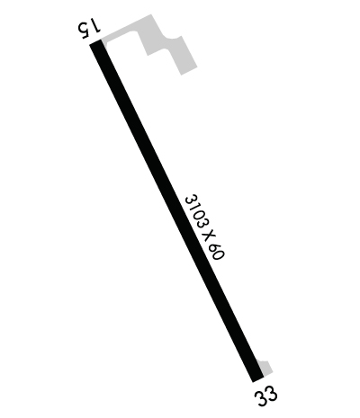
| Lat: N 4715.6 Long: W 09624.0 Elev: 954 Var: -05 Longest Runway: 3103 | ||
| CTAF: 122.9 | ||
| ||||||
|
| Rwy | Rwy | |||||||
| 3103x60 | 3103' | 3103x60 | 3103' | |||||
| Runway ID | Single Wheel | Double Wheel | Double Tandem Wheel | Dual Double Wheel |
| 15/33 | N/A | N/A | N/A | N/A |
| These numbers are Advisory and are not limits. The Airport Manager should have more accurate Weight Limits | ||||
 Airport Diagram might not be current. | |
| Facility Name: | NORMAN COUNTY ADA/TWIN VALLEY |
| City Name: | ADA/TWIN VALLEY |
| County: | NORMAN |
| State abbrev: | MN |
| State Name: | MINNESOTA |
| Ownership: | PUBLICLY OWNED |
| Use: | OPEN TO THE PUBLIC |
| Owner's Name: | CNTY NORMAN & ADA-TWIN VALLEY |
| Address: | PO BOX 32 |
| ADA, MN 56510 | |
| Owner's Phone: | 218-784-5520 |
| Manager's Name: | BRUCE VISSER |
| Address: | P.O. BOX 9 |
| ADA, MN 56510 | |
| Phone: | 218-784-2962; ARPT MGR CELL PHONE 218-415-0191 |
| FAA Region: | GREAT LAKES |
| FAA Field Office: | DMA |
| Date | Sunrise | Sunset |
|---|---|---|
| 09/24/21 Friday | 7:15 | 19:20 |
| 09/25/21 Saturday | 7:16 | 19:18 |
| 09/26/21 Sunday | 7:17 | 19:16 |
| 09/27/21 Monday | 7:19 | 19:14 |
| 09/28/21 Tuesday | 7:20 | 19:12 |
| 09/29/21 Wednesday | 7:21 | 19:10 |
| 09/30/21 Thursday | 7:23 | 19:08 |
| 10/01/21 Friday | 7:24 | 19:06 |
| 10/02/21 Saturday | 7:26 | 19:04 |
| 10/03/21 Sunday | 7:27 | 19:02 |
| 10/04/21 Monday | 7:28 | 19:00 |
| 10/05/21 Tuesday | 7:30 | 18:58 |
| 10/06/21 Wednesday | 7:31 | 18:56 |
| 10/07/21 Thursday | 7:32 | 18:54 |
| Airport Attendance Schedule | UNATTENDED |
| Airport Status | OPERATIONAL (This Status can change at any time - please check NOTAMS) |
| Airport Lighting Schedule | SS-SR |
| Airport Storage Available | Tie Downs |
| Extra Services Available | Crop Dusting, Aircraft Sales |
| Wind Indicator | YES - (lighted) |
| Control Tower | NO |
| CTAF Frequency | 122.900 |
| Unicom Frequency | |
| Rotating Beacon Color | CLEAR-GREEN (Light Land Airport) |
| Segmented Circle | NO |
| Landing Fee |
| Airport Inspected | STATE - performed by STATE AERONAUTICAL PERSONNEL |
| Inspection Date | 08/09/2018 |
| Type of Fuel Available | Grade 100LL; -10FUEL AVAIL 24 HOUR WITH CREDIT CARD. |
| Airframe Repair Service | None |
| Power Plant Repair Service | None |
| Latitude | N4715.6 |
| Longitude | W09624.0 (ESTIMATED) |
| Arpt Elevation | 954ft (ESTIMATED) |
| Magnetic Variation | 05E |
| 5 miles SE | of ADA/TWIN VALLEY |
| Traffic Pattern Altitude | 800 |
| Sectional Chart | TWIN CITIES |
| Operations (Reported) | Yearly | Avg. Daily |
|---|---|---|
| General Aviation Transient | 2200 | 6 |
| General Aviation Local | 3000 | 8 |
| Air Taxi | 0 | 0 |
| Commerical | 0 | 0 |
| Commuter | 0 | 0 |
| Military | 0 | 0 |
| Aircraft based on Field | |
|---|---|
| General Aviation Singles | 8 |
| General Aviation Multi | 0 |
| Jet Aircraft | 0 |
| General Aviation Helicopters | 0 |
| Military Aircraft | 0 |
| Gliders | 0 |
| Ultralights | 0 |
| FSS on field | NO |
| FSS tie-in | PRINCETON |
| FSS Phone | 1-800-WX-BRIEF |
| Who issues Notams | PNM |
| Notam D service at airport | YES |
| ARTCC Name | MINNEAPOLIS |
| Airport Certification | |
| Aircraft Rescue & Firefighting Index | None |
| Airport of Entry | No |
| Custom Landing Rights | No |
| Joint Civil/Military | No |
| Military Landing rights | No |
| ULTRALIGHTS ON & INVOF ARPT. |
| FOR CD CTC FARGO APCH AT 701-235-8894. |
| RWY 15/3 3 CRACKING AND SURFACE EROSION. |
| RWY 15/3 3 SEVERAL LIGHTS LEANING. |
Airport Communications & Frequencies:
| ||||||||||||
| Runway: 15 | Runway: 33 | ||
| Mag heading: | 149° | Mag heading: | 329° |
| Rwy Slope: | .52% Up | Rwy Slope: | -.52% Down |
| Approach: | Approach: | ||
| Pattern: | Left Traffic | Pattern: | Left Traffic |
| Markings: | NONPRECISION INSTRUMENT | Markings: | NONPRECISION INSTRUMENT |
| Marking Condition: | FAIR | Marking Condition: | FAIR |
| Arresting Dev: | Arresting Dev: | ||
| Lat & Long: | N4715.9 W09624.2 | Lat. & Long.: | N4715.4 W09623.9 |
| Elev: | 938.0 ft. MSL | Elev: | 954.0 ft. MSL |
| TCH: | TCH: | ||
| Visual Glide Path: | Visual Glide Path: | ||
| Displaced Threshold: | No | Displaced Threshold: | No |
| Touchdown Zone: | YES | Touchdown Zone: | YES |
| Touchdown Elev.: | 954.0 feet | Touchdown Elev.: | 954.0 feet |
| Visual Glide Slope: | Visual Glide Slope: | ||
| RVR Equipment: | RVR Equipment: | ||
| RVV Equipment: | NO | RVV Equipment: | NO |
| Approach Lights: | Approach Lights: | ||
| REIL: | NO | REIL: | NO |
| Centerline Lights: | NO | Centerline Lights: | NO |
| Touchdown lights: | NO | Touchdown lights: | NO |
| Runway Category: | Runway with a Visual Approach | Runway Category: | Runway with a Non-precision Approach |
| Declared Distances: | Declared Distances: | ||
| Obstructions: | BRUSH | Obstructions: | |
| Marked: | NOT Marked/Lighted | Marked: | |
| Clearance slope: | 7:1 | Clearance slope: | 20:1 |
| Obstruction height: | 7 feet AGL | Obstruction height: | |
| Dist. from runway: | 250 feet | Dist. from runway: | |
| Centerline offset: | 87 right of centerline | Centerline offset: | |
| Comments: | RWY 15 HAS 7 FT BRUSH 37 FT FROM THE RWY END AND 94 FT L. | Comments: | RWY 33 HAS 7 FT BRUSH 32 FT FROM THE RWY END AND 100 FT R. |
Thanks for using FltPlan.com
all rights reserved © 1999-2021 by Flight Plan LLC
