
| COZAD MUNI COZAD NE |
| |
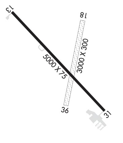
| Lat: N 4052.2 Long: W 10000.3 Elev: 2503 Var: -07 Longest Runway: 5000 | ||
| CTAF: 122.8 | ||
| ||||||
|
| Rwy | Rwy | |||||||
| 5000x75 | 5000' | 5000x75 | 5000' | |||||
| 3000x300 | 2980' | 3000x300 | 3000' | |||||
| Runway ID | Single Wheel | Double Wheel | Double Tandem Wheel | Dual Double Wheel |
| 13/31 | 30,000 | N/A | N/A | N/A |
| 18/36 | N/A | N/A | N/A | N/A |
| These numbers are Advisory and are not limits. The Airport Manager should have more accurate Weight Limits | ||||
 Airport Diagram might not be current. | |
| Facility Name: | COZAD MUNI |
| City Name: | COZAD |
| County: | DAWSON |
| State abbrev: | NE |
| State Name: | NEBRASKA |
| Ownership: | PUBLICLY OWNED |
| Use: | OPEN TO THE PUBLIC |
| Owner's Name: | COZAD AIRPORT AUTHORITY |
| Address: | PO BOX 2000 |
| COZAD, NE 69130-2000 | |
| Owner's Phone: | 308-784-3868 |
| Manager's Name: | ALLISON DONNER |
| Address: | P.O. BOX 458 |
| COZAD, NE 69130-0458 | |
| Phone: | 308-784-3868 |
| FAA Region: | CENTRAL |
| FAA Field Office: | NONE |
| Date | Sunrise | Sunset |
|---|---|---|
| 06/12/26 Friday | 6:08 | 21:12 |
| 06/13/26 Saturday | 6:08 | 21:13 |
| 06/14/26 Sunday | 6:08 | 21:13 |
| 06/15/26 Monday | 6:08 | 21:13 |
| 06/16/26 Tuesday | 6:08 | 21:14 |
| 06/17/26 Wednesday | 6:08 | 21:14 |
| 06/18/26 Thursday | 6:08 | 21:14 |
| 06/19/26 Friday | 6:08 | 21:15 |
| 06/20/26 Saturday | 6:08 | 21:15 |
| 06/21/26 Sunday | 6:08 | 21:15 |
| 06/22/26 Monday | 6:09 | 21:15 |
| 06/23/26 Tuesday | 6:09 | 21:16 |
| 06/24/26 Wednesday | 6:09 | 21:16 |
| 06/25/26 Thursday | 6:09 | 21:16 |
| Airport Attendance Schedule | MON-FRI 0800-1700 |
| Airport Status | OPERATIONAL (This Status can change at any time - please check NOTAMS) |
| Airport Lighting Schedule | ACTVT PAPI RWY 13 & 31; MIRL RWY 13/31 - CTAF. |
| Airport Storage Available | Tie Downs, Hanger |
| Extra Services Available | Crop Dusting, Flight Instruction, Aircraft Rental, Aircraft Sales |
| Wind Indicator | YES - (lighted) |
| Control Tower | NO |
| CTAF Frequency | 122.800 |
| Unicom Frequency | 122.800 |
| Rotating Beacon Color | WG |
| Segmented Circle | YES |
| Landing Fee | NO |
| Airport Inspected | STATE - performed by STATE AERONAUTICAL PERSONNEL |
| Inspection Date | 07/25/2024 |
| Type of Fuel Available | Grade 100LL, JET A (freeze point -40C); -10AVBL H24 VIA CREDIT CARD.; -A AVBL H24 VIA CREDIT CARD. |
| Airframe Repair Service | NONE |
| Power Plant Repair Service | NONE |
| Latitude | N4052.2 |
| Longitude | W10000.3 (ESTIMATED) |
| Arpt Elevation | 2503ft (SURVEYED) |
| Magnetic Variation | 07E |
| 1 miles NW | of COZAD |
| Traffic Pattern Altitude | |
| Sectional Chart | OMAHA |
| Operations (Reported) | Yearly | Avg. Daily |
|---|---|---|
| General Aviation Transient | 0 | 0 |
| General Aviation Local | 0 | 0 |
| Air Taxi | 0 | 0 |
| Commerical | 0 | 0 |
| Commuter | 0 | 0 |
| Military | 0 | 0 |
| Aircraft based on Field | |
|---|---|
| General Aviation Singles | 0 |
| General Aviation Multi | 0 |
| Jet Aircraft | 0 |
| General Aviation Helicopters | 0 |
| Military Aircraft | 0 |
| Gliders | 0 |
| Ultralights | 0 |
| FSS on field | NO |
| FSS tie-in | COLUMBUS |
| FSS Phone | 1-800-WX-BRIEF |
| Who issues Notams | OLU |
| Notam D service at airport | YES |
| ARTCC Name | DENVER |
| Airport Certification | |
| Aircraft Rescue & Firefighting Index | None |
| Airport of Entry | No |
| Custom Landing Rights | No |
| Joint Civil/Military | No |
| Military Landing rights | YES |
| NATIONAL PLAN OF INTEGRATED AIRPORT SYSTEMS (NPIAS) |
| GRANT AGREEMENTS UNDER FAAP/ADAP/AIP |
| ASSURANCES PURSUANT TO TITLE VI, CIVIL RIGHTS ACT OF 1964 |
| RWY 18/36 NOT PLOWED WINTER MONTHS. |
| FOR CD CTC DENVER ARTCC AT 303-651-4257. |
Airport Communications & Frequencies:
| |||||||||
| Runway: 13 | Runway: 31 | ||
| Mag heading: | 130° | Mag heading: | 310° |
| Rwy Slope: | -.12% Down | Rwy Slope: | .12% Up |
| Approach: | Approach: | ||
| Pattern: | Left Traffic | Pattern: | Left Traffic |
| Markings: | NONPRECISION INSTRUMENT | Markings: | NONPRECISION INSTRUMENT |
| Marking Condition: | GOOD | Marking Condition: | GOOD |
| Arresting Dev: | Arresting Dev: | ||
| Lat & Long: | N4052.5 W10000.7 | Lat. & Long.: | N4051.9 W09959.9 |
| Elev: | 2503.2 ft. MSL | Elev: | 2497.3 ft. MSL |
| TCH: | 52 ft. AGL | TCH: | 49 ft. AGL |
| Visual Glide Path: | 3.00 degrees | Visual Glide Path: | 3.75 degrees |
| Displaced Threshold: | No | Displaced Threshold: | No |
| Touchdown Zone: | YES | Touchdown Zone: | YES |
| Touchdown Elev.: | 2503.2 feet | Touchdown Elev.: | 2501.3 feet |
| Visual Glide Slope: | 2-Light PAPI on LEFT side of Runway | Visual Glide Slope: | 2-Light PAPI on LEFT side of Runway |
| RVR Equipment: | RVR Equipment: | ||
| RVV Equipment: | NO | RVV Equipment: | NO |
| Approach Lights: | Approach Lights: | ||
| REIL: | NO | REIL: | NO |
| Centerline Lights: | NO | Centerline Lights: | NO |
| Touchdown lights: | NO | Touchdown lights: | NO |
| Runway Category: | Runway with a Non-precision Approach having visibility minimums greater than 3/4 mile | Runway Category: | Runway with a Non-precision Approach having visibility minimums greater than 3/4 mile |
| Declared Distances: | Declared Distances: | ||
| Obstructions: | GRAIN ELEVATOR. | Obstructions: | OTHER |
| Marked: | NOT Marked/Lighted | Marked: | LIGHTED |
| Clearance slope: | 34:1 | Clearance slope: | 20:1; CLNC SLP 26:1 ALSO DUE TO ROAD 631 FT OUT 16 FT ABV 0B. |
| Obstruction height: | Obstruction height: | 167 feet AGL | |
| Dist. from runway: | Dist. from runway: | 3560 feet | |
| Centerline offset: | Centerline offset: | 330 feet right of centerline | |
| Comments: | Comments: |
| Runway: 18 | Runway: 36 | ||
| Mag heading: | 184° | Mag heading: | 4° |
| Rwy Slope: | -.08% Down | Rwy Slope: | .08% Up |
| Approach: | Approach: | ||
| Pattern: | Left Traffic | Pattern: | Left Traffic |
| Markings: | Markings: | ||
| Marking Condition: | MKD WITH YELLOW CONES. | Marking Condition: | MKD WITH YELLOW CONES. |
| Arresting Dev: | Arresting Dev: | ||
| Lat & Long: | N4052.4 W10000.1 | Lat. & Long.: | N4051.9 W10000.2 |
| Elev: | 2499.5 ft. MSL | Elev: | 2497.2 ft. MSL |
| TCH: | TCH: | ||
| Visual Glide Path: | Visual Glide Path: | ||
| Displaced Threshold: | 20 feet | Displaced Threshold: | No |
| Touchdown Zone: | YES | Touchdown Zone: | YES |
| Touchdown Elev.: | 2499.9 feet | Touchdown Elev.: | 2499.9 feet |
| Visual Glide Slope: | Visual Glide Slope: | ||
| RVR Equipment: | RVR Equipment: | ||
| RVV Equipment: | NO | RVV Equipment: | NO |
| Approach Lights: | Approach Lights: | ||
| REIL: | NO | REIL: | NO |
| Centerline Lights: | NO | Centerline Lights: | NO |
| Touchdown lights: | NO | Touchdown lights: | NO |
| Runway Category: | Runway with a Visual Approach | Runway Category: | Runway with a Visual Approach |
| Declared Distances: | Declared Distances: | ||
| Obstructions: | ROAD | Obstructions: | RR |
| Marked: | NOT Marked/Lighted | Marked: | NOT Marked/Lighted |
| Clearance slope: | 20:1 | Clearance slope: | 20:1 |
| Obstruction height: | 15 feet AGL | Obstruction height: | 25 feet AGL |
| Dist. from runway: | 309 feet | Dist. from runway: | 515 feet |
| Centerline offset: | 156 right of centerline | Centerline offset: | 176 feet left of centerline |
| Comments: | Comments: |
Thanks for using FltPlan.com
all rights reserved © 1999-2026 by Flight Plan LLC
