
| JEAN LESAGE INTL QUEBEC QC |
| |
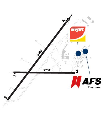
| Lat: N 4647.5 Long: W 07123.6 Elev: 243 Var: +16 Longest Runway: 9000 | ||
| Dept. ATIS: 134.6 Arr. ATIS: 134.6 Ground: 121.9/250 Tower: 118.65/236.6 | ||
| |||||||||||||||||||||||||||||||||||||||||||||||||||||||||||||||||||||
| |||||||||||||||||||||||||||||||||||||||||||||||||||||||||||||||||||||
| |||||||||||||||||||||||||||||||||||||||||||||||||||||||||||||||||||||
| |||||||||||||||||||||||||||||||||||||||||||||||||||||||||||||||||||||
| |||||||||||||||||||||||||||||||||||||||||||||||||||||||||||||||||||||
| |||||||||||||||||||||||||||||||||||||||||||||||||||||||||||||||||||||
| |||||||||||||||||||||||||||||||||||||||||||||||||||||||||||||||||||||
| Rwy | Rwy | |||||||
| 9000x150 | 9000' | 9000x150 | 9000' | |||||
| 5700x150 | 5700' | 5700x150 | 5700' | |||||
| Runway ID | Single Wheel | Double Wheel | Double Tandem Wheel | Dual Double Wheel |
| 06/24 | N/A | N/A | N/A | N/A |
| 12/30 | N/A | N/A | N/A | N/A |
| These numbers are Advisory and are not limits. The Airport Manager should have more accurate Weight Limits | ||||
 Airport Diagram might not be current. | |
| Facility Name: | QUEBEC/JEAN LESAGE INTL |
| City Name: | QUEBEC |
| County: | QUEBEC, CANADA |
| State abbrev: | |
| State Name: | |
| Ownership: | PUBLICLY OWNED |
| Use: | OPEN TO THE PUBLIC |
| Owner's Name: | |
| Address: | |
| Owner's Phone: | |
| Manager's Name: | |
| Address: | |
| Phone: | |
| FAA Region: | |
| FAA Field Office: | NONE |
| Date | Sunrise | Sunset |
|---|---|---|
| 06/27/26 Saturday | 4:53 | 20:44 |
| 06/28/26 Sunday | 4:54 | 20:44 |
| 06/29/26 Monday | 4:54 | 20:44 |
| 06/30/26 Tuesday | 4:55 | 20:44 |
| 07/01/26 Wednesday | 4:55 | 20:43 |
| 07/02/26 Thursday | 4:56 | 20:43 |
| 07/03/26 Friday | 4:56 | 20:43 |
| 07/04/26 Saturday | 4:57 | 20:42 |
| 07/05/26 Sunday | 4:58 | 20:42 |
| 07/06/26 Monday | 4:59 | 20:42 |
| 07/07/26 Tuesday | 4:59 | 20:41 |
| 07/08/26 Wednesday | 5:00 | 20:41 |
| 07/09/26 Thursday | 5:01 | 20:40 |
| 07/10/26 Friday | 5:02 | 20:40 |
| Airport Attendance Schedule | |
| Airport Status | OPERATIONAL (This Status can change at any time - please check NOTAMS) |
| Airport Lighting Schedule | |
| Airport Storage Available | NONE |
| Extra Services Available | NONE |
| Wind Indicator | NONE |
| Control Tower | NO |
| CTAF Frequency | |
| Unicom Frequency | |
| Rotating Beacon Color | |
| Segmented Circle | NO |
| Landing Fee |
| Airport Inspected | No Inspection Data Available performed by the OWNER |
| Inspection Date | Unknown |
| Type of Fuel Available | None |
| Airframe Repair Service | None |
| Power Plant Repair Service | None |
| Latitude | N4647.5 |
| Longitude | W07123.6 (ESTIMATED) |
| Arpt Elevation | 244ft (ESTIMATED) |
| Magnetic Variation | 17W |
| 6 miles WSW | of QUEBEC |
| Traffic Pattern Altitude | |
| Sectional Chart |
| Operations (Reported) | Yearly | Avg. Daily |
|---|---|---|
| General Aviation Transient | 0 | 0 |
| General Aviation Local | 0 | 0 |
| Air Taxi | 0 | 0 |
| Commerical | 0 | 0 |
| Commuter | 0 | 0 |
| Military | 0 | 0 |
| Aircraft based on Field | |
|---|---|
| General Aviation Singles | 0 |
| General Aviation Multi | 0 |
| Jet Aircraft | 0 |
| General Aviation Helicopters | 0 |
| Military Aircraft | 0 |
| Gliders | 0 |
| Ultralights | 0 |
| FSS on field | NO |
| FSS tie-in | QUEBEC |
| FSS Phone | |
| Who issues Notams | |
| Notam D service at airport | No |
| ARTCC Name | MONTREAL |
| Airport Certification | |
| Aircraft Rescue & Firefighting Index | None |
| Airport of Entry | No |
| Custom Landing Rights | No |
| Joint Civil/Military | No |
| Military Landing rights | No |
| Runway: 06 | Runway: 24 | ||
| Approach: | Approach: | ||
| Pattern: | Pattern: | ||
| Markings: | Markings: | ||
| Marking Condition: | Marking Condition: | ||
| Arresting Dev: | Arresting Dev: | ||
| Lat & Long: | Lat. & Long.: | ||
| Elev: | N/A | Elev: | N/A |
| TCH: | TCH: | ||
| Visual Glide Path: | Visual Glide Path: | ||
| Displaced Threshold: | No | Displaced Threshold: | No |
| Touchdown Zone: | NO | Touchdown Zone: | NO |
| Touchdown Elev.: | Touchdown Elev.: | ||
| Visual Glide Slope: | Visual Glide Slope: | ||
| RVR Equipment: | RVR Equipment: | ||
| RVV Equipment: | NO | RVV Equipment: | NO |
| Approach Lights: | Approach Lights: | ||
| REIL: | NO | REIL: | NO |
| Centerline Lights: | NO | Centerline Lights: | NO |
| Touchdown lights: | NO | Touchdown lights: | NO |
| Runway Category: | Runway Category: | ||
| Declared Distances: | Declared Distances: |
| Runway: 12 | Runway: 30 | ||
| Approach: | Approach: | ||
| Pattern: | Pattern: | ||
| Markings: | Markings: | ||
| Marking Condition: | Marking Condition: | ||
| Arresting Dev: | Arresting Dev: | ||
| Lat & Long: | Lat. & Long.: | ||
| Elev: | N/A | Elev: | N/A |
| TCH: | TCH: | ||
| Visual Glide Path: | Visual Glide Path: | ||
| Displaced Threshold: | No | Displaced Threshold: | No |
| Touchdown Zone: | NO | Touchdown Zone: | NO |
| Touchdown Elev.: | Touchdown Elev.: | ||
| Visual Glide Slope: | Visual Glide Slope: | ||
| RVR Equipment: | RVR Equipment: | ||
| RVV Equipment: | NO | RVV Equipment: | NO |
| Approach Lights: | Approach Lights: | ||
| REIL: | NO | REIL: | NO |
| Centerline Lights: | NO | Centerline Lights: | NO |
| Touchdown lights: | NO | Touchdown lights: | NO |
| Runway Category: | Runway Category: | ||
| Declared Distances: | Declared Distances: |
Thanks for using FltPlan.com
all rights reserved © 1999-2026 by Flight Plan LLC


