
| CHASE CITY MUNI CHASE CITY VA |
| |
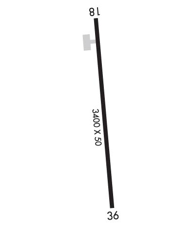
| Lat: N 3647.3 Long: W 07830.1 Elev: 503 Var: +09 Longest Runway: 3400 | ||
| AWOS: 121.22 CTAF: 122.9 | ||
| ||||||||||||||||||||||||||||||||
| ||||||||||||||||||||||||||||||||
| ||||||||||||||||||||||||||||||||
| Rwy | Rwy | |||||||
| 3400x50 | 3400' | 3400x50 | 3400' | |||||
| Runway ID | Single Wheel | Double Wheel | Double Tandem Wheel | Dual Double Wheel |
| 18/36 | 12,500 | N/A | N/A | N/A |
| These numbers are Advisory and are not limits. The Airport Manager should have more accurate Weight Limits | ||||
 Airport Diagram might not be current. | |
| Facility Name: | CHASE CITY MUNI |
| City Name: | CHASE CITY |
| County: | MECKLENBURG |
| State abbrev: | VA |
| State Name: | VIRGINIA |
| Ownership: | PUBLICLY OWNED |
| Use: | OPEN TO THE PUBLIC |
| Owner's Name: | TOWN OF CHASE CITY |
| Address: | 319 N MAIN ST |
| CHASE CITY, VA 23924 | |
| Owner's Phone: | 434-372-5136 |
| Manager's Name: | CHARLES FORBES; TOWN MANAGER. |
| Address: | 319 N MAIN ST |
| CHASE CITY, VA 23924 | |
| Phone: | 434-372-5136 |
| FAA Region: | EASTERN |
| FAA Field Office: | DCA |
| Date | Sunrise | Sunset |
|---|---|---|
| 06/08/26 Monday | 5:55 | 20:31 |
| 06/09/26 Tuesday | 5:55 | 20:32 |
| 06/10/26 Wednesday | 5:55 | 20:32 |
| 06/11/26 Thursday | 5:54 | 20:33 |
| 06/12/26 Friday | 5:54 | 20:33 |
| 06/13/26 Saturday | 5:54 | 20:34 |
| 06/14/26 Sunday | 5:54 | 20:34 |
| 06/15/26 Monday | 5:54 | 20:35 |
| 06/16/26 Tuesday | 5:54 | 20:35 |
| 06/17/26 Wednesday | 5:55 | 20:35 |
| 06/18/26 Thursday | 5:55 | 20:36 |
| 06/19/26 Friday | 5:55 | 20:36 |
| 06/20/26 Saturday | 5:55 | 20:36 |
| 06/21/26 Sunday | 5:55 | 20:36 |
| Airport Attendance Schedule | UNATTENDED |
| Airport Status | OPERATIONAL (This Status can change at any time - please check NOTAMS) |
| Airport Lighting Schedule | |
| Airport Storage Available | Tie Downs |
| Extra Services Available | NONE |
| Wind Indicator | YES - (unlit) |
| Control Tower | NO |
| CTAF Frequency | 122.900 |
| Unicom Frequency | |
| Rotating Beacon Color | |
| Segmented Circle | NO |
| Landing Fee | NO |
| Airport Inspected | STATE - performed by STATE AERONAUTICAL PERSONNEL |
| Inspection Date | 07/11/2024 |
| Type of Fuel Available | None |
| Airframe Repair Service | None |
| Power Plant Repair Service | None |
| Latitude | N3647.3 |
| Longitude | W07830.1 (ESTIMATED) |
| Arpt Elevation | 503ft (SURVEYED) |
| Magnetic Variation | 09W |
| 2 miles W | of CHASE CITY |
| Traffic Pattern Altitude | 800 |
| Sectional Chart | WASHINGTON |
| Operations (Reported) | Yearly | Avg. Daily |
|---|---|---|
| General Aviation Transient | 0 | 0 |
| General Aviation Local | 0 | 0 |
| Air Taxi | 0 | 0 |
| Commerical | 0 | 0 |
| Commuter | 0 | 0 |
| Military | 0 | 0 |
| Aircraft based on Field | |
|---|---|
| General Aviation Singles | 0 |
| General Aviation Multi | 0 |
| Jet Aircraft | 0 |
| General Aviation Helicopters | 0 |
| Military Aircraft | 0 |
| Gliders | 0 |
| Ultralights | 0 |
| FSS on field | NO |
| FSS tie-in | LEESBURG |
| FSS Phone | 1-800-WX-BRIEF |
| Who issues Notams | DCA |
| Notam D service at airport | YES |
| ARTCC Name | WASHINGTON |
| Airport Certification | |
| Aircraft Rescue & Firefighting Index | None |
| Airport of Entry | No |
| Custom Landing Rights | No |
| Joint Civil/Military | No |
| Military Landing rights | YES |
| GRANT AGREEMENTS UNDER FAAP/ADAP/AIP |
| ASSURANCES PURSUANT TO TITLE VI, CIVIL RIGHTS ACT OF 1964 |
| THIS AIRPORT HAS BEEN SURVEYED BY THE NATIONAL GEODETIC SURVEY. |
| DEER ON & INVOF ARPT. |
| FARM EQUIP OPERATING NEAR RWY. |
| ARPT CLSD SS-SR INDEFLY. |
| FOR CD CTC WASHINGTON ARTCC AT 703-771-3587. |
| RWY 18/3 6 SEVERE RWY CRACKING. 1-2 INCHES IN PLACES AND ALG CNTRLN. |
| RWY 18/3 6 1LONGITUDINAL AND TRANSVERSE CRACKING. SOME RAVELING IN CERTAIN AREAS. |
| RWY 18 1 MARKINGS SEVERELY FADED AND RAVELING. |
| RWY 36 1 MARKINGS SEVERELY FADED AND RAVELING. |
Airport Communications & Frequencies:
| |||||||
| Runway: 18 | Runway: 36 | ||
| Mag heading: | 184° | Mag heading: | 4° |
| Rwy Slope: | -.50% Down | Rwy Slope: | .50% Up |
| Approach: | Approach: | ||
| Pattern: | Left Traffic | Pattern: | Left Traffic |
| Markings: | NONPRECISION INSTRUMENT | Markings: | NONPRECISION INSTRUMENT |
| Marking Condition: | POOR; MARKINGS SEVERELY FADED | Marking Condition: | POOR; MARKINGS SEVERELY FADED |
| Arresting Dev: | Arresting Dev: | ||
| Lat & Long: | N3647.6 W07830.1 | Lat. & Long.: | N3647.0 W07830.1 |
| Elev: | 503.0 ft. MSL | Elev: | 486.0 ft. MSL |
| TCH: | TCH: | ||
| Visual Glide Path: | Visual Glide Path: | ||
| Displaced Threshold: | No | Displaced Threshold: | No |
| Touchdown Zone: | YES | Touchdown Zone: | YES |
| Touchdown Elev.: | 503.0 feet | Touchdown Elev.: | 503.0 feet |
| Visual Glide Slope: | Visual Glide Slope: | ||
| RVR Equipment: | RVR Equipment: | ||
| RVV Equipment: | NO | RVV Equipment: | NO |
| Approach Lights: | Approach Lights: | ||
| REIL: | NO | REIL: | NO |
| Centerline Lights: | NO | Centerline Lights: | NO |
| Touchdown lights: | NO | Touchdown lights: | NO |
| Runway Category: | Runway with a Visual Approach | Runway Category: | Runway with a Visual Approach |
| Declared Distances: | Declared Distances: | ||
| Obstructions: | ROAD | Obstructions: | BRUSH |
| Marked: | NOT Marked/Lighted | Marked: | NOT Marked/Lighted |
| Clearance slope: | Clearance slope: | 1:1 | |
| Obstruction height: | 23 feet AGL | Obstruction height: | 31 feet AGL |
| Dist. from runway: | 200 feet | Dist. from runway: | 247 feet |
| Centerline offset: | 108 right of centerline | Centerline offset: | 115 feet right of centerline |
| Comments: | +6 FT GND 115 FT R OF RWY END; +20 FT ROAD 100 FT FM THR, 125 FT R. | Comments: | RISING GND 150 FT FM RWY END; 30 FT TREES 100 FT BOTH SIDES OF CNTRLN. |
Thanks for using FltPlan.com
all rights reserved © 1999-2026 by Flight Plan LLC
