NOTICE: Information listed below may not be current.Airport Ident: KCWS
| Airport Name: DENNIS F CANTRELL FLD, ARKANSAS
Location: Conway
Latitude: N3504.8 Longitude: W09225.5
Field Elevation: 315' Variation: E2° as of 01/06
Time Zone: UTC-6(-5DT)
Daylight Savings: First Sunday in April at 0200 to last Sunday in October at 0200 local time (Exception Arizona and that portion of Indiana in the Eastern Time Zone)
Customs: N/A
|
|
| DISTANCE from: | KTEB to KCWS = 933 nm
| KMIA to KCWS = 837 nm
| KORD to KCWS = 466 nm
| KDAL to KCWS = 258 nm
| KSEA to KCWS = 1526 nm
| KLAX to KCWS = 1283 nm
|
|
| AIRPORT TYPE: | | Active airports having permanent type surface runways with less than the minimum facilities. |
|
Rotating Beacon: YES
|
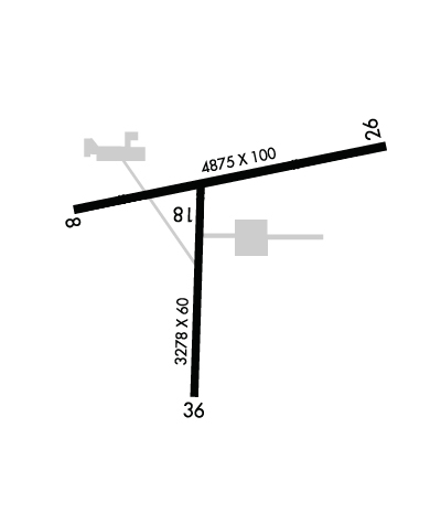
| RUNWAY INFORMATION: | Runway Ident: 26 /08
Runway Length: 4875
Runway Width: 100
Runway Surface: ASPHALT, ASPHALTIC CONCRETE, TAR MACADAM, OR BITUMEN BOUND MACADAM (INCLUDING ANY OF THESE SURFACE TYPES WITH CONCRETE ENDS).
Runway PCN Rating: -
Runway PCN Evaluation Method: N/A
Runway Open: YES
| Runway 26 Information
Runway True Heading: 259°
Runway Displaced Threshold: 164.3'
Takeoff Distance Available: 4875
Landing Distance Available: 3232
Runway Latitude: N3505.0
Runway Longitude: W09225.0
Runway Elevation: 299'
Runway Slope: .3°
Runway TDZE: 315'
Runway Lighting: PCL, HIRL, REIL, PAPI
| Runway 08 Information
Runway True Heading: 79°
Runway Displaced Threshold: 83.1
Takeoff Distance Available: 4875
Landing Distance Available: 4044
Runway Latitude: N3504.9
Runway Longitude: W09225.9
Runway Elevation: 315'
Runway Slope: -.3°
Runway TDZE: N/A
Runway Lighting: PCL, HIRL, PAPI
|
Runway Ident: 36 /18
Runway Length: 3278
Runway Width: 60
Runway Surface: ASPHALT, ASPHALTIC CONCRETE, TAR MACADAM, OR BITUMEN BOUND MACADAM (INCLUDING ANY OF THESE SURFACE TYPES WITH CONCRETE ENDS).
Runway PCN Rating: -
Runway PCN Evaluation Method: N/A
Runway Open: YES
| Runway 36 Information
Runway True Heading: 3°
Takeoff Distance Available: 3278
Landing Distance Available: 3278
Runway Latitude: N3504.4
Runway Longitude: W09225.5
Runway Elevation: 315'
Runway Slope: -.3°
Runway TDZE:
Runway Lighting: PCL, HIRL, REIL, PAPI
| Runway 18 Information
Runway True Heading: 183°
Runway Displaced Threshold: 15.5
Takeoff Distance Available: 3278
Landing Distance Available: 3123
Runway Latitude: N3505.0
Runway Longitude: W09225.5
Runway Elevation: 306'
Runway Slope: .3°
Runway TDZE: N/A
Runway Lighting: PCL, HIRL, PAPI
|
|
|
COMMUNICATION INFORMATION
APPROACH/DEPARTURE CONTROL - LITTLE ROCK APP/DEP
119.5 306.2
CLEARANCE DELIVERY - LITTLE ROCK CLNC DEL
121.2
UNICOM OR CTAF/UNICOM - CTAF/UNICOM
122.8
|
COMMUNICATION REMARKS
CLEARANCE DELIVERY - C501-379-2908.
|
AIRPORT NAVAIDS
CWS - CONWAY (NDB) - ON FIELD
|