
| CHARLEVOIX MUNI CHARLEVOIX MI |
| |
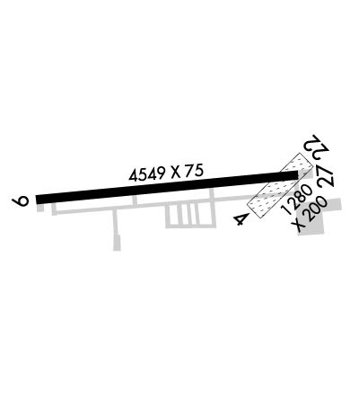
| Lat: N 4518.3 Long: W 08516.5 Elev: 669 Var: +05 Longest Runway: 4549 | ||
| Clr Del: 121.72 (GCO) AWOS: 120.0 CTAF: 122.8 | ||
| ||||||
| ||||||
|
| Rwy | Rwy | |||||||
| 1280x200 | 1280' | 1280x200 | 1280' | |||||
| 4549x75 | 4549' | 4549x75 | 4549' | |||||
| Runway ID | Single Wheel | Double Wheel | Double Tandem Wheel | Dual Double Wheel |
| 04/22 | N/A | N/A | N/A | N/A |
| 09/27 | 12,500 | N/A | N/A | N/A |
| These numbers are Advisory and are not limits. The Airport Manager should have more accurate Weight Limits | ||||
 Airport Diagram might not be current. | |
| Facility Name: | CHARLEVOIX MUNI |
| City Name: | CHARLEVOIX |
| County: | CHARLEVOIX |
| State abbrev: | MI |
| State Name: | MICHIGAN |
| Ownership: | PUBLICLY OWNED |
| Use: | OPEN TO THE PUBLIC |
| Owner's Name: | CITY OF CHARLEVOIX |
| Address: | 210 STATE STREET |
| CHARLEVOIX, MI 49720 | |
| Owner's Phone: | 231-547-3270 |
| Manager's Name: | MATT WYMAN |
| Address: | 210 STATE STREET |
| CHARLEVOIX, MI 49720 | |
| Phone: | 231-547-3605; 231-547-3605 |
| FAA Region: | GREAT LAKES |
| FAA Field Office: | DET |
| Date | Sunrise | Sunset |
|---|---|---|
| 09/24/21 Friday | 7:30 | 19:35 |
| 09/25/21 Saturday | 7:31 | 19:33 |
| 09/26/21 Sunday | 7:33 | 19:31 |
| 09/27/21 Monday | 7:34 | 19:29 |
| 09/28/21 Tuesday | 7:35 | 19:28 |
| 09/29/21 Wednesday | 7:36 | 19:26 |
| 09/30/21 Thursday | 7:38 | 19:24 |
| 10/01/21 Friday | 7:39 | 19:22 |
| 10/02/21 Saturday | 7:40 | 19:20 |
| 10/03/21 Sunday | 7:41 | 19:18 |
| 10/04/21 Monday | 7:43 | 19:16 |
| 10/05/21 Tuesday | 7:44 | 19:14 |
| 10/06/21 Wednesday | 7:45 | 19:12 |
| 10/07/21 Thursday | 7:46 | 19:11 |
| Airport Attendance Schedule | JUN-AUG 7 Days A Week 0800-1900, SEP-MAY 7 Days A Week 0800-1700; UNATNDD MAJOR HOLS. |
| Airport Status | OPERATIONAL (This Status can change at any time - please check NOTAMS) |
| Airport Lighting Schedule | ACTVT REIL RWY 9 & 27; PAPI RWY 09 & 27; MIRL RWY 9/27 - CTAF. |
| Airport Storage Available | Tie Downs |
| Extra Services Available | Charter |
| Wind Indicator | YES - (lighted) |
| Control Tower | NO |
| CTAF Frequency | 122.800 |
| Unicom Frequency | 122.800 |
| Rotating Beacon Color | CLEAR-GREEN (Light Land Airport) |
| Segmented Circle | YES |
| Landing Fee | YES; LDG FEE WAIVED WITH MINIMUM FUEL PURCHASE. |
| Airport Inspected | STATE - performed by STATE AERONAUTICAL PERSONNEL |
| Inspection Date | 06/03/2019 |
| Type of Fuel Available | Grade 100LL, JET A (freeze point -40C); -10AFT HRS FUEL CTC 231-547-3605. |
| Airframe Repair Service | MAJOR |
| Power Plant Repair Service | MAJOR |
| Latitude | N4518.3 |
| Longitude | W08516.5 (ESTIMATED) |
| Arpt Elevation | 668ft (SURVEYED) |
| Magnetic Variation | 05W |
| 1 miles SW | of CHARLEVOIX |
| Traffic Pattern Altitude | |
| Sectional Chart | GREEN BAY |
| Operations (Reported) | Yearly | Avg. Daily |
|---|---|---|
| General Aviation Transient | 9500 | 26 |
| General Aviation Local | 8000 | 22 |
| Air Taxi | 12000 | 33 |
| Commerical | 0 | 0 |
| Commuter | 0 | 0 |
| Military | 500 | 1 |
| Aircraft based on Field | |
|---|---|
| General Aviation Singles | 10 |
| General Aviation Multi | 4 |
| Jet Aircraft | 2 |
| General Aviation Helicopters | 0 |
| Military Aircraft | 0 |
| Gliders | 0 |
| Ultralights | 0 |
| FSS on field | NO |
| FSS tie-in | LANSING |
| FSS Phone | 1-800-WX-BRIEF |
| Who issues Notams | CVX |
| Notam D service at airport | YES |
| ARTCC Name | MINNEAPOLIS |
| Airport Certification | |
| Aircraft Rescue & Firefighting Index | None |
| Airport of Entry | No |
| Custom Landing Rights | No |
| Joint Civil/Military | No |
| Military Landing rights | YES |
| NATIONAL PLAN OF INTEGRATED AIRPORT SYSTEMS (NPIAS) |
| GRANT AGREEMENT HAS EXPIRED; HOWEVER, AGREEMENT REMAINS IN EFFECT FOR THIS FACILITY AS LONG AS IT IS PUBLIC USE. |
| RWY 09/27 SLOPES UP FROM E TO W. |
| FOR CD CTC MINNEAPOLIS ARTCC AT 651-463-5588. |
| DEER & BIRDS ON & INVOF ARPT. |
| -100 FT QUARRY/MINE 300 FT FM RWY 9 THR. |
| CHARLEVOIX VOLUNTARY QUIET HOURS ARE IN EFFECT FROM 11PM TO 7AM DAILY |
| RWY 04/2 2 MKD WITH 3 FT YELLOW CONES. CLSD NOV-APR. |
| RWY 09 PREFERRED RWY FOR LDG 11PM TO 7AM. |
| RWY 27 PREFERRED RWY FOR TKOF 11PM TO 7AM. |
Airport Communications & Frequencies:
| |||||||||
| Runway: 04 | Runway: 22 | ||
| Mag heading: | 45° | Mag heading: | 225° |
| Rwy Slope: | -.45% Down | Rwy Slope: | .45% Up |
| Approach: | Approach: | ||
| Pattern: | Left Traffic | Pattern: | Left Traffic |
| Markings: | Markings: | ||
| Marking Condition: | Marking Condition: | ||
| Arresting Dev: | Arresting Dev: | ||
| Lat & Long: | N4518.2 W08516.3 | Lat. & Long.: | N4518.4 W08516.1 |
| Elev: | 646.0 ft. MSL | Elev: | 640.2 ft. MSL |
| TCH: | TCH: | ||
| Visual Glide Path: | Visual Glide Path: | ||
| Displaced Threshold: | No | Displaced Threshold: | No |
| Touchdown Zone: | YES | Touchdown Zone: | YES |
| Touchdown Elev.: | 646.0 feet | Touchdown Elev.: | 646.0 feet |
| Visual Glide Slope: | Visual Glide Slope: | ||
| RVR Equipment: | RVR Equipment: | ||
| RVV Equipment: | NO | RVV Equipment: | NO |
| Approach Lights: | Approach Lights: | ||
| REIL: | NO | REIL: | NO |
| Centerline Lights: | NO | Centerline Lights: | NO |
| Touchdown lights: | NO | Touchdown lights: | NO |
| Runway Category: | Runway with a Visual Approach | Runway Category: | Runway with a Visual Approach |
| Declared Distances: | Declared Distances: | ||
| Obstructions: | TREES | Obstructions: | TREE |
| Marked: | NOT Marked/Lighted | Marked: | NOT Marked/Lighted |
| Clearance slope: | 20:1 | Clearance slope: | 20:1 |
| Obstruction height: | 100 feet AGL | Obstruction height: | 95 feet AGL |
| Dist. from runway: | 2000 feet | Dist. from runway: | 1900 feet |
| Centerline offset: | Centerline offset: | ||
| Comments: | Comments: |
| Runway: 09 | Runway: 27 | ||
| Mag heading: | 90° | Mag heading: | 270° |
| Rwy Slope: | -.56% Down | Rwy Slope: | .56% Up |
| Approach: | Approach: | ||
| Pattern: | Left Traffic | Pattern: | Left Traffic |
| Markings: | NONPRECISION INSTRUMENT | Markings: | NONPRECISION INSTRUMENT |
| Marking Condition: | FAIR | Marking Condition: | FAIR |
| Arresting Dev: | Arresting Dev: | ||
| Lat & Long: | N4518.3 W08517.1 | Lat. & Long.: | N4518.3 W08516.1 |
| Elev: | 668.8 ft. MSL | Elev: | 643.1 ft. MSL |
| TCH: | 39 ft. AGL | TCH: | 31 ft. AGL |
| Visual Glide Path: | 3.00 degrees | Visual Glide Path: | 3.00 degrees |
| Displaced Threshold: | No | Displaced Threshold: | No |
| Touchdown Zone: | YES | Touchdown Zone: | YES |
| Touchdown Elev.: | 668.9 feet | Touchdown Elev.: | 661.5 feet |
| Visual Glide Slope: | 4-Light PAPI on RIGHT side of Runway | Visual Glide Slope: | 4-Light PAPI on RIGHT side of Runway |
| RVR Equipment: | RVR Equipment: | ||
| RVV Equipment: | NO | RVV Equipment: | NO |
| Approach Lights: | Approach Lights: | ||
| REIL: | YES | REIL: | YES |
| Centerline Lights: | NO | Centerline Lights: | NO |
| Touchdown lights: | NO | Touchdown lights: | NO |
| Runway Category: | Runway with a Non-precision Approach | Runway Category: | Runway with a Non-precision Approach |
| Declared Distances: | Declared Distances: | ||
| Obstructions: | TREE | Obstructions: | TREES |
| Marked: | NOT Marked/Lighted | Marked: | NOT Marked/Lighted |
| Clearance slope: | 34:1 | Clearance slope: | 26:1 |
| Obstruction height: | 7 feet AGL | Obstruction height: | 52 feet AGL |
| Dist. from runway: | 438 feet | Dist. from runway: | 1575 feet |
| Centerline offset: | 20 left of centerline | Centerline offset: | 250 feet right of centerline |
| Comments: | Comments: |
Thanks for using FltPlan.com
all rights reserved © 1999-2021 by Flight Plan LLC
