
| CLOVIS MUNI CLOVIS NM |
| |
| Lat: N 3425.6 Long: W 10304.7 Elev: 4216 Var: -09 Longest Runway: 7200 | ||
| Clr Del: 119.0 AWOS: 135.37 CTAF: 122.8 | ||
| ||||||||||||||||||||||||||||||||||||||||||||
| ||||||||||||||||||||||||||||||||||||||||||||
| ||||||||||||||||||||||||||||||||||||||||||||
| Rwy | Rwy | |||||||
| 7200x150 | 7200' | 108.90 - 036° | 7200x150 | 7200' | ||||
| 2442x75 | 2442' | 2442x75 | 2442' | |||||
| 5697x150 | 5697' | 5697x150 | 5697' | |||||
| Runway ID | Single Wheel | Double Wheel | Double Tandem Wheel | Dual Double Wheel |
| 04/22 | 45,000 | 57,000 | N/A | N/A |
| 08/26 | N/A | N/A | N/A | N/A |
| 12/30 | 42,000 | 50,000 | N/A | N/A |
| These numbers are Advisory and are not limits. The Airport Manager should have more accurate Weight Limits | ||||
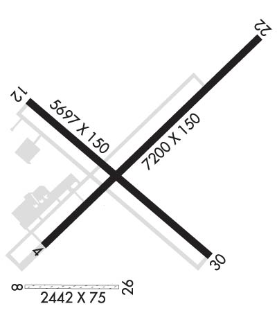 Airport Diagram might not be current. | |
| Facility Name: | CLOVIS RGNL |
| City Name: | CLOVIS |
| County: | CURRY |
| State abbrev: | NM |
| State Name: | NEW MEXICO |
| Ownership: | PUBLICLY OWNED |
| Use: | OPEN TO THE PUBLIC |
| Owner's Name: | CITY OF CLOVIS |
| Address: | PO BOX 760 |
| CLOVIS, NM 88101 | |
| Owner's Phone: | (575) 769-7890 |
| Manager's Name: | JAMES HARRIS |
| Address: | PO BOX 760 |
| CLOVIS, NM 88101 | |
| Phone: | 575-763-9618 |
| FAA Region: | SOUTHWEST |
| FAA Field Office: | LNM |
| Date | Sunrise | Sunset |
|---|---|---|
| 09/24/21 Friday | 6:42 | 18:46 |
| 09/25/21 Saturday | 6:42 | 18:45 |
| 09/26/21 Sunday | 6:43 | 18:44 |
| 09/27/21 Monday | 6:44 | 18:42 |
| 09/28/21 Tuesday | 6:45 | 18:41 |
| 09/29/21 Wednesday | 6:45 | 18:39 |
| 09/30/21 Thursday | 6:46 | 18:38 |
| 10/01/21 Friday | 6:47 | 18:37 |
| 10/02/21 Saturday | 6:47 | 18:35 |
| 10/03/21 Sunday | 6:48 | 18:34 |
| 10/04/21 Monday | 6:49 | 18:33 |
| 10/05/21 Tuesday | 6:50 | 18:31 |
| 10/06/21 Wednesday | 6:51 | 18:30 |
| 10/07/21 Thursday | 6:51 | 18:29 |
| Airport Attendance Schedule | 7 Days A Week 0700-1700 |
| Airport Status | OPERATIONAL (This Status can change at any time - please check NOTAMS) |
| Airport Lighting Schedule | ACTVT MALSR RWY 04; PAPI RWY 04; MIRL RWY 04/22 & 12/30 - CTAF. |
| Airport Storage Available | Tie Downs, Hanger |
| Extra Services Available | Air Freight, Crop Dusting, Air Ambulance, Flight Instruction, Aircraft Rental, Aircraft Sales |
| Wind Indicator | YES - (lighted) |
| Control Tower | NO |
| CTAF Frequency | 122.800 |
| Unicom Frequency | 122.800 |
| Rotating Beacon Color | CLEAR-GREEN (Light Land Airport) |
| Segmented Circle | YES |
| Landing Fee | NO |
| Airport Inspected | STATE - performed by FAA AIRPORTS FIELD PERSONNEL |
| Inspection Date | 11/14/2019 |
| Type of Fuel Available | Grade 100LL, JET A (freeze point -40C); -10AFT HRS FUEL CALL 575-763-9615. |
| Airframe Repair Service | MAJOR |
| Power Plant Repair Service | MAJOR |
| Latitude | N3425.6 |
| Longitude | W10304.7 (ESTIMATED) |
| Arpt Elevation | 4215ft (SURVEYED) |
| Magnetic Variation | 09E |
| 6 miles E | of CLOVIS |
| Traffic Pattern Altitude | 800 |
| Sectional Chart | ALBUQUERQUE |
| Operations (Reported) | Yearly | Avg. Daily |
|---|---|---|
| General Aviation Transient | 11867 | 33 |
| General Aviation Local | 9120 | 25 |
| Air Taxi | 1905 | 5 |
| Commerical | 0 | 0 |
| Commuter | 0 | 0 |
| Military | 1756 | 5 |
| Aircraft based on Field | |
|---|---|
| General Aviation Singles | 41 |
| General Aviation Multi | 8 |
| Jet Aircraft | 6 |
| General Aviation Helicopters | 1 |
| Military Aircraft | 0 |
| Gliders | 0 |
| Ultralights | 0 |
| FSS on field | NO |
| FSS tie-in | ALBUQUERQUE |
| FSS Phone | 1-800-WX-BRIEF |
| Who issues Notams | CVN |
| Notam D service at airport | YES |
| ARTCC Name | ALBUQUERQUE |
| Airport Certification | AIRPORT RECEIVING SCHEDULED AIR CARRIER SERVICE FROM CARRIERS CERTIFICATED BY THE CIVIL AERONAUTICS BOARD |
| Aircraft Rescue & Firefighting Index | AIRPORT HAS A CERTIFICATE UNDER CFR PART 139 |
| Airport of Entry | No |
| Custom Landing Rights | No |
| Joint Civil/Military | No |
| Military Landing rights | YES |
| NATIONAL PLAN OF INTEGRATED AIRPORT SYSTEMS (NPIAS) |
| GRANT AGREEMENTS UNDER FAAP/ADAP/AIP |
| ASSURANCES PURSUANT TO TITLE VI, CIVIL RIGHTS ACT OF 1964 |
| CAUTION: HEAVY JET TFC; CANNON AFB 13 NM SW. |
| RWY 22 PREFERRED RY FOR CALM WIND. |
| EXTENSIVE AGRICULTURAL ACFT ACTIVITY ON & INVOF ARPT. |
| FOR CD IF UNA TO CTC ON FSS FREQ, CTC ALBUQUERQUE ARTCC AT 505-856-4561. |
Airport Communications & Frequencies:
| ||||||||||||||||
| Runway: 04 | Runway: 22 | ||
| Mag heading: | 37° | Mag heading: | 217° |
| Rwy Slope: | .28% Up | Rwy Slope: | -.28% Down |
| Approach: | ILS | Approach: | |
| Pattern: | Left Traffic | Pattern: | Left Traffic |
| Markings: | PRECISION INSTRUMENT | Markings: | NONPRECISION INSTRUMENT |
| Marking Condition: | GOOD | Marking Condition: | GOOD |
| Arresting Dev: | Arresting Dev: | ||
| Lat & Long: | N3425.3 W10305.1 | Lat. & Long.: | N3426.2 W10304.0 |
| Elev: | 4194.3 ft. MSL | Elev: | 4214.2 ft. MSL |
| TCH: | 53 ft. AGL | TCH: | 47 ft. AGL |
| Visual Glide Path: | 3.00 degrees | Visual Glide Path: | 3.00 degrees |
| Displaced Threshold: | No | Displaced Threshold: | No |
| Touchdown Zone: | YES | Touchdown Zone: | YES |
| Touchdown Elev.: | 4204.6 feet | Touchdown Elev.: | 4214.2 feet |
| Visual Glide Slope: | 4-Light PAPI on LEFT side of Runway | Visual Glide Slope: | 4-Light PAPI on LEFT side of Runway |
| RVR Equipment: | RVR Equipment: | ||
| RVV Equipment: | NO | RVV Equipment: | NO |
| Approach Lights: | MALSR - 1,400 foot medium intensity approach lighting system with runway alignment indicator lights | Approach Lights: | |
| REIL: | NO | REIL: | NO |
| Centerline Lights: | NO | Centerline Lights: | NO |
| Touchdown lights: | NO | Touchdown lights: | NO |
| Runway Category: | Precision Instrument Runway | Runway Category: | Runway with a Non-precision Approach having visibility minimums greater than 3/4 mile |
| Declared Distances: | Declared Distances: | ||
| Obstructions: | ROAD | Obstructions: | ROAD |
| Marked: | NOT Marked/Lighted | Marked: | NOT Marked/Lighted |
| Clearance slope: | 4:1; +15 FT ROAD DIST 960 FT 600 FT RIGHT; 50:1 ALL DATA BASED ON DSPLCD THLD. | Clearance slope: | |
| Obstruction height: | 12 feet AGL | Obstruction height: | 12 feet AGL |
| Dist. from runway: | 250 feet | Dist. from runway: | 200 feet |
| Centerline offset: | 510 right of centerline | Centerline offset: | 450 feet right of centerline |
| Comments: | Comments: |
| Runway: 08 | Runway: 26 | ||
| Mag heading: | 81° | Mag heading: | 261° |
| Rwy Slope: | -.43% Down | Rwy Slope: | .43% Up |
| Approach: | Approach: | ||
| Pattern: | Left Traffic | Pattern: | Left Traffic |
| Markings: | Markings: | ||
| Marking Condition: | Marking Condition: | ||
| Arresting Dev: | Arresting Dev: | ||
| Lat & Long: | N3425.2 W10305.1 | Lat. & Long.: | N3425.2 W10304.6 |
| Elev: | 4195.7 ft. MSL | Elev: | 4185.3 ft. MSL |
| TCH: | TCH: | ||
| Visual Glide Path: | Visual Glide Path: | ||
| Displaced Threshold: | No | Displaced Threshold: | No |
| Touchdown Zone: | NO | Touchdown Zone: | NO |
| Touchdown Elev.: | Touchdown Elev.: | ||
| Visual Glide Slope: | Visual Glide Slope: | ||
| RVR Equipment: | RVR Equipment: | ||
| RVV Equipment: | NO | RVV Equipment: | NO |
| Approach Lights: | Approach Lights: | ||
| REIL: | NO | REIL: | NO |
| Centerline Lights: | NO | Centerline Lights: | NO |
| Touchdown lights: | NO | Touchdown lights: | NO |
| Runway Category: | Runway with a Visual Approach | Runway Category: | Runway with a Visual Approach |
| Declared Distances: | Declared Distances: | ||
| Obstructions: | PLINE | Obstructions: | |
| Marked: | NOT Marked/Lighted | Marked: | |
| Clearance slope: | 37:1 | Clearance slope: | 50:1 |
| Obstruction height: | 47 feet AGL | Obstruction height: | |
| Dist. from runway: | 1783 feet | Dist. from runway: | |
| Centerline offset: | Centerline offset: | ||
| Comments: | Comments: |
| Runway: 12 | Runway: 30 | ||
| Mag heading: | 121° | Mag heading: | 301° |
| Rwy Slope: | -.50% Down | Rwy Slope: | .50% Up |
| Approach: | Approach: | ||
| Pattern: | Left Traffic | Pattern: | Left Traffic |
| Markings: | NONPRECISION INSTRUMENT | Markings: | NONPRECISION INSTRUMENT |
| Marking Condition: | GOOD | Marking Condition: | GOOD |
| Arresting Dev: | Arresting Dev: | ||
| Lat & Long: | N3425.9 W10305.1 | Lat. & Long.: | N3425.3 W10304.3 |
| Elev: | 4215.8 ft. MSL | Elev: | 4187.1 ft. MSL |
| TCH: | TCH: | 75 ft. AGL | |
| Visual Glide Path: | Visual Glide Path: | 3.00 degrees | |
| Displaced Threshold: | No | Displaced Threshold: | No |
| Touchdown Zone: | YES | Touchdown Zone: | YES |
| Touchdown Elev.: | 4215.8 feet | Touchdown Elev.: | 4202.0 feet |
| Visual Glide Slope: | Visual Glide Slope: | PULSATING/STEADY BURNING VASI ON LEFT SIDE OF RUNWAY | |
| RVR Equipment: | RVR Equipment: | ||
| RVV Equipment: | NO | RVV Equipment: | NO |
| Approach Lights: | Approach Lights: | ||
| REIL: | YES | REIL: | YES |
| Centerline Lights: | NO | Centerline Lights: | NO |
| Touchdown lights: | NO | Touchdown lights: | NO |
| Runway Category: | Runway with a Visual Approach | Runway Category: | Runway with a Visual Approach |
| Declared Distances: | Declared Distances: | ||
| Obstructions: | ROAD | Obstructions: | ROAD |
| Marked: | NOT Marked/Lighted | Marked: | NOT Marked/Lighted |
| Clearance slope: | 38:1 | Clearance slope: | 45:1 |
| Obstruction height: | 16 feet AGL | Obstruction height: | 10 feet AGL |
| Dist. from runway: | 820 feet | Dist. from runway: | 650 feet |
| Centerline offset: | 320 left of centerline | Centerline offset: | 280 feet right of centerline |
| Comments: | Comments: |
Thanks for using FltPlan.com
all rights reserved © 1999-2021 by Flight Plan LLC
