
| HOLLISTER MUNI HOLLISTER CA |
| |
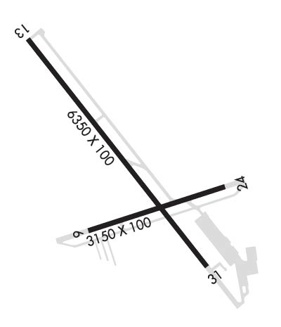
| Lat: N 3653.6 Long: W 12124.6 Elev: 231 Var: -15 Longest Runway: 6350 | ||
| AWOS: 120.42 CTAF: 123.0 | ||
| ||||||||||||||||||||||||||||||||||||||||||||
| ||||||||||||||||||||||||||||||||||||||||||||
| ||||||||||||||||||||||||||||||||||||||||||||
| Rwy | Rwy | |||||||
| 3149x100 | 3149' | 3149x100 | 3149' | |||||
| 6350x100 | 6350' | 6350x100 | 6350' | |||||
| Runway ID | Single Wheel | Double Wheel | Double Tandem Wheel | Dual Double Wheel |
| 06/24 | 30,000 | 45,000 | N/A | N/A |
| 13/31 | 30,000 | 45,000 | N/A | N/A |
| These numbers are Advisory and are not limits. The Airport Manager should have more accurate Weight Limits | ||||
 Airport Diagram might not be current. | |
| Facility Name: | HOLLISTER MUNI |
| City Name: | HOLLISTER |
| County: | SAN BENITO |
| State abbrev: | CA |
| State Name: | CALIFORNIA |
| Ownership: | PUBLICLY OWNED |
| Use: | OPEN TO THE PUBLIC |
| Owner's Name: | CITY OF HOLLISTER |
| Address: | 375 5TH ST. |
| HOLLISTER, CA 95023 | |
| Owner's Phone: | 831-636-4365 |
| Manager's Name: | MIKE CHAMBLESS |
| Address: | 60 AIRPORT DRIVE |
| HOLLISTER, CA 95023 | |
| Phone: | 831-636-4365; FAX (831)636-4366. |
| FAA Region: | WESTERN-PACIFIC |
| FAA Field Office: | SFO |
| Date | Sunrise | Sunset |
|---|---|---|
| 09/24/21 Friday | 6:55 | 19:00 |
| 09/25/21 Saturday | 6:56 | 18:58 |
| 09/26/21 Sunday | 6:57 | 18:57 |
| 09/27/21 Monday | 6:57 | 18:55 |
| 09/28/21 Tuesday | 6:58 | 18:54 |
| 09/29/21 Wednesday | 6:59 | 18:52 |
| 09/30/21 Thursday | 7:00 | 18:51 |
| 10/01/21 Friday | 7:01 | 18:49 |
| 10/02/21 Saturday | 7:02 | 18:48 |
| 10/03/21 Sunday | 7:03 | 18:46 |
| 10/04/21 Monday | 7:03 | 18:45 |
| 10/05/21 Tuesday | 7:04 | 18:43 |
| 10/06/21 Wednesday | 7:05 | 18:42 |
| 10/07/21 Thursday | 7:06 | 18:40 |
| Airport Attendance Schedule | 7 Days A Week 0800-1700; AMGR AT ARPT MON-FRI 0800-1500. |
| Airport Status | OPERATIONAL (This Status can change at any time - please check NOTAMS) |
| Airport Lighting Schedule | ACTVT REIL RWY 24, 13, & 31; VASI RWY 24; PAPI RWY 13 & 31; MIRL RWY 06/24 & 13/31 - CTAF. |
| Airport Storage Available | Tie Downs |
| Extra Services Available | Glider, Flight Instruction, Aircraft Rental, Aircraft Sales |
| Wind Indicator | YES - (lighted) |
| Control Tower | NO |
| CTAF Frequency | 123.000 |
| Unicom Frequency | 123.000 |
| Rotating Beacon Color | CLEAR-GREEN (Light Land Airport) |
| Segmented Circle | YES |
| Landing Fee | NO |
| Airport Inspected | STATE - performed by STATE AERONAUTICAL PERSONNEL |
| Inspection Date | 11/06/2019 |
| Type of Fuel Available | Grade 100LL, JET A (freeze point -40C); -10FUEL AVBL 24 HRS CREDIT CARD LOCK SYSTEM. |
| Airframe Repair Service | MAJOR |
| Power Plant Repair Service | MAJOR |
| Latitude | N3653.6 |
| Longitude | W12124.6 (ESTIMATED) |
| Arpt Elevation | 230ft (SURVEYED) |
| Magnetic Variation | 15E |
| 3 miles N | of HOLLISTER |
| Traffic Pattern Altitude | 800; TPA FOR HELICOPTERS 500 FT AGL. |
| Sectional Chart | SAN FRANCISCO |
| Operations (Reported) | Yearly | Avg. Daily |
|---|---|---|
| General Aviation Transient | 26179 | 72 |
| General Aviation Local | 30098 | 82 |
| Air Taxi | 0 | 0 |
| Commerical | 0 | 0 |
| Commuter | 0 | 0 |
| Military | 1212 | 3 |
| Aircraft based on Field | |
|---|---|
| General Aviation Singles | 70 |
| General Aviation Multi | 7 |
| Jet Aircraft | 5 |
| General Aviation Helicopters | 5 |
| Military Aircraft | 0 |
| Gliders | 20 |
| Ultralights | 2 |
| FSS on field | NO |
| FSS tie-in | OAKLAND |
| FSS Phone | 1-800-WX-BRIEF |
| Who issues Notams | OAK |
| Notam D service at airport | YES |
| ARTCC Name | OAKLAND |
| Airport Certification | |
| Aircraft Rescue & Firefighting Index | None |
| Airport of Entry | No |
| Custom Landing Rights | No |
| Joint Civil/Military | No |
| Military Landing rights | YES |
| NATIONAL PLAN OF INTEGRATED AIRPORT SYSTEMS (NPIAS) |
| GRANT AGREEMENTS UNDER FAAP/ADAP/AIP |
| SURPLUS PROPERTY AGREEMENT UNDER PUBLIC LAW 289 |
| SURPLUS PROPERTY AGREEMENT UNDER REGULATION 16-WAA |
| ASSURANCES PURSUANT TO TITLE VI, CIVIL RIGHTS ACT OF 1964 |
| MODEL ACFT CLUB CONDUCTING FLT OPNS 3 MILES WNW OF ARPT HEADING OF 290 DEGREES FM ARPT SURFACE TO 500' AGL. |
| CAUTION - WATCH FOR FIRE FIGHTING ACFT MAY THRU OCT. |
| GLIDER ACTIVITY ON AND INVOF ARPT. |
| RECOMMEND PILOTS TO BEGIN RY 31 TAKEOFF ROLL AT OR BEYOND THE THLD (PAST TAXIWAY B). |
| FOR CD CTC NORCAL APCH AT 916-361-3748. |
Airport Communications & Frequencies:
| ||||||||||||||
| Runway: 06 | Runway: 24 | ||
| Mag heading: | 57° | Mag heading: | 237° |
| Rwy Slope: | -.04% Down | Rwy Slope: | .04% Up |
| Approach: | Approach: | ||
| Pattern: | Left Traffic | Pattern: | Left Traffic |
| Markings: | BASIC | Markings: | BASIC |
| Marking Condition: | GOOD | Marking Condition: | GOOD |
| Arresting Dev: | Arresting Dev: | ||
| Lat & Long: | N3653.4 W12124.8 | Lat. & Long.: | N3653.5 W12124.2 |
| Elev: | 224.1 ft. MSL | Elev: | 222.9 ft. MSL |
| TCH: | TCH: | 26 ft. AGL | |
| Visual Glide Path: | Visual Glide Path: | 3.75 degrees | |
| Displaced Threshold: | No | Displaced Threshold: | No |
| Touchdown Zone: | YES | Touchdown Zone: | YES |
| Touchdown Elev.: | 224.1 feet | Touchdown Elev.: | 223.9 feet |
| Visual Glide Slope: | Visual Glide Slope: | 2-Box VASI on LEFT side of Runway | |
| RVR Equipment: | RVR Equipment: | ||
| RVV Equipment: | NO | RVV Equipment: | NO |
| Approach Lights: | Approach Lights: | ||
| REIL: | NO | REIL: | YES |
| Centerline Lights: | NO | Centerline Lights: | NO |
| Touchdown lights: | NO | Touchdown lights: | NO |
| Runway Category: | Runway with a Visual Approach | Runway Category: | Runway with a Visual Approach |
| Declared Distances: | Declared Distances: | ||
| Obstructions: | HILL | Obstructions: | ROAD |
| Marked: | NOT Marked/Lighted | Marked: | NOT Marked/Lighted |
| Clearance slope: | 23:1 | Clearance slope: | 20:1 |
| Obstruction height: | 65 feet AGL | Obstruction height: | 15 feet AGL |
| Dist. from runway: | 1700 feet | Dist. from runway: | 510 feet |
| Centerline offset: | 100 right of centerline | Centerline offset: | |
| Comments: | Comments: |
| Runway: 13 | Runway: 31 | ||
| Mag heading: | 127° | Mag heading: | 307° |
| Rwy Slope: | .43% Up | Rwy Slope: | -.43% Down |
| Approach: | Approach: | ||
| Pattern: | Left Traffic | Pattern: | Left Traffic |
| Markings: | NONPRECISION INSTRUMENT | Markings: | NONPRECISION INSTRUMENT |
| Marking Condition: | GOOD | Marking Condition: | GOOD |
| Arresting Dev: | Arresting Dev: | ||
| Lat & Long: | N3654.1 W12125.1 | Lat. & Long.: | N3653.3 W12124.3 |
| Elev: | 203.2 ft. MSL | Elev: | 230.6 ft. MSL |
| TCH: | 44 ft. AGL | TCH: | 44 ft. AGL |
| Visual Glide Path: | 3.00 degrees | Visual Glide Path: | 3.00 degrees |
| Displaced Threshold: | No | Displaced Threshold: | No |
| Touchdown Zone: | YES | Touchdown Zone: | YES |
| Touchdown Elev.: | 215.0 feet | Touchdown Elev.: | 230.6 feet |
| Visual Glide Slope: | 2-Light PAPI on LEFT side of Runway | Visual Glide Slope: | 2-Light PAPI on LEFT side of Runway |
| RVR Equipment: | RVR Equipment: | ||
| RVV Equipment: | NO | RVV Equipment: | NO |
| Approach Lights: | Approach Lights: | ||
| REIL: | YES | REIL: | YES |
| Centerline Lights: | NO | Centerline Lights: | NO |
| Touchdown lights: | NO | Touchdown lights: | NO |
| Runway Category: | Runway with a Visual Approach | Runway Category: | Runway with a Non-precision Approach having visibility minimums greater than 3/4 mile |
| Declared Distances: | Declared Distances: |
Thanks for using FltPlan.com
all rights reserved © 1999-2021 by Flight Plan LLC
