
| CINCINNATI/NORTHERN KENTUCKY COVINGTON KY |
| |
| Lat: N 3902.9 Long: W 08440.1 Elev: 896 Var: +06 Longest Runway: 12001 | ||
| Clr Del: 127.17 Dept. ATIS: 135.3 Arr. ATIS: 134.37 Ground: 121.7 Tower: 118.3 /118.97 | ||
| |||||||||||||||||||||||||||||||||||||||||||||||||||||||||||||||||||||
| |||||||||||||||||||||||||||||||||||||||||||||||||||||||||||||||||||||
| |||||||||||||||||||||||||||||||||||||||||||||||||||||||||||||||||||||
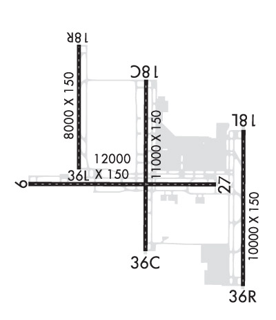
| Rwy | Rwy | |||||||
| 12001x150 | 12001' | 111.90 - 096° | 12001x150 | 12001' | 108.70 - 276° | |||
| 11000x150 | 11000' | 111.55 - 186° | 11000x150 | 11000' | 109.90 - 006° | |||
| 10000x150 | 10000' | 110.15 - 186° | 10000x150 | 10000' | 110.35 - 006° | |||
| 8000x150 | 8000' | 110.75 - 186° | 8000x150 | 8000' | 110.75 - 006° | |||
| Runway ID | Single Wheel | Double Wheel | Double Tandem Wheel | Dual Double Wheel |
| 09/27 | 120,000 | 250,000 | 550,000 | 875,000 |
| 18C/36C | 120,000 | 250,000 | 550,000 | 875,000 |
| 18L/36R | 120,000 | 250,000 | 550,000 | 875,000 |
| 18R/36L | 120,000 | 250,000 | 550,000 | 875,000 |
| These numbers are Advisory and are not limits. The Airport Manager should have more accurate Weight Limits | ||||
 Airport Diagram might not be current. | |
| Facility Name: | CINCINNATI/NORTHERN KENTUCKY INTL |
| City Name: | COVINGTON |
| County: | BOONE |
| State abbrev: | KY |
| State Name: | KENTUCKY |
| Ownership: | PUBLICLY OWNED |
| Use: | OPEN TO THE PUBLIC |
| Owner's Name: | KENTON COUNTY ARPT BOARD |
| Address: | PO BOX 752000 |
| CINCINNATI, OH 45275-2000 | |
| Owner's Phone: | 859-767-3151 |
| Manager's Name: | LARRY KRAUTER |
| Address: | PO BOX 752000 |
| CINCINNATI, OH 45275-2000 | |
| Phone: | 859-767-3151 |
| FAA Region: | SOUTHERN |
| FAA Field Office: | MEM |
| Date | Sunrise | Sunset |
|---|---|---|
| 06/08/26 Monday | 6:13 | 21:03 |
| 06/09/26 Tuesday | 6:13 | 21:03 |
| 06/10/26 Wednesday | 6:12 | 21:04 |
| 06/11/26 Thursday | 6:12 | 21:04 |
| 06/12/26 Friday | 6:12 | 21:05 |
| 06/13/26 Saturday | 6:12 | 21:05 |
| 06/14/26 Sunday | 6:12 | 21:06 |
| 06/15/26 Monday | 6:12 | 21:06 |
| 06/16/26 Tuesday | 6:12 | 21:06 |
| 06/17/26 Wednesday | 6:12 | 21:07 |
| 06/18/26 Thursday | 6:12 | 21:07 |
| 06/19/26 Friday | 6:13 | 21:07 |
| 06/20/26 Saturday | 6:13 | 21:08 |
| 06/21/26 Sunday | 6:13 | 21:08 |
| Airport Attendance Schedule | CONTINUOUS |
| Airport Status | OPERATIONAL (This Status can change at any time - please check NOTAMS) |
| Airport Lighting Schedule | |
| Airport Storage Available | Tie Downs, Hanger |
| Extra Services Available | Air Freight, Avionics, Cargo Handling, Charter |
| Wind Indicator | YES - (lighted) |
| Control Tower | YES |
| CTAF Frequency | |
| Unicom Frequency | 122.950 |
| Rotating Beacon Color | WG |
| Segmented Circle | NO |
| Landing Fee | NO |
| Airport Inspected | FEDERAL - performed by FAA AIRPORTS FIELD PERSONNEL |
| Inspection Date | 07/25/2025 |
| Type of Fuel Available | Grade 100LL, JET A (freeze point -40C) |
| Airframe Repair Service | MAJOR |
| Power Plant Repair Service | MAJOR |
| Latitude | N3902.9 |
| Longitude | W08440.1 (ESTIMATED) |
| Arpt Elevation | 896ft (SURVEYED) |
| Magnetic Variation | 06W |
| 8 miles SW | of COVINGTON |
| Traffic Pattern Altitude | |
| Sectional Chart | CINCINNATI |
| Operations (Reported) | Yearly | Avg. Daily |
|---|---|---|
| General Aviation Transient | 0 | 0 |
| General Aviation Local | 0 | 0 |
| Air Taxi | 0 | 0 |
| Commerical | 0 | 0 |
| Commuter | 0 | 0 |
| Military | 0 | 0 |
| Aircraft based on Field | |
|---|---|
| General Aviation Singles | 0 |
| General Aviation Multi | 0 |
| Jet Aircraft | 0 |
| General Aviation Helicopters | 0 |
| Military Aircraft | 0 |
| Gliders | 0 |
| Ultralights | 0 |
| FSS on field | NO |
| FSS tie-in | LOUISVILLE |
| FSS Phone | 1-800-WX-BRIEF |
| Who issues Notams | CVG |
| Notam D service at airport | YES |
| ARTCC Name | INDIANAPOLIS |
| Airport Certification | AIRPORT RECEIVING SCHEDULED AIR CARRIER SERVICE FROM CARRIERS CERTIFICATED BY THE CIVIL AERONAUTICS BOARD; ARFF INDEX E AVBL UPON REQ. |
| Aircraft Rescue & Firefighting Index | AIRPORT HAS A CERTIFICATE UNDER CFR PART 139 |
| Airport of Entry | No |
| Custom Landing Rights | YES |
| Joint Civil/Military | No |
| Military Landing rights | YES |
| NATIONAL PLAN OF INTEGRATED AIRPORT SYSTEMS (NPIAS) |
| GRANT AGREEMENTS UNDER FAAP/ADAP/AIP |
| ASSURANCES PURSUANT TO TITLE VI, CIVIL RIGHTS ACT OF 1964 |
| SUCCESSIVE OR SIMUL DEP FM RWY 18L, 18C, 36L, 36C & 36R APVD WITH COURSE DVRG BGN NO FURTHER THAN 2 MI FM EOR DUE TO NOISE ABATEMENT. |
| TWYS RSTRD TO 15 MPH OR LESS WITH WINGSPAN 214 FT OR MORE. |
| BIRDS ON & INVOF THE ARPT. |
| RAMP CTL: RAMP 1N / 1S TXL & RAMP 2N / 2S TXL - 130.90, RAMP 3 TXL & N TXL - 130.375; DHL RAMP CTL: 129.475; AMZ RAMP CTL: 130.5. |
| NOISE SENS AREA N & S OF ARPT; RWY ASGN 2200-0700 BASED ON NOISE ABATEMENT. |
| RWY 09/2 7 W 4200 FT & E 750 FT CONC; REMAINDER ASPH OVERLAY. |
| RWY 18R/ 36LCLSD TO PAX ACFT WITH WINGSPAN GTR THAN 140 FT. |
| RWY 09/2 7 PCR VALUE: 922/R/B/W/T |
| RWY 18C/ 36CPCR VALUE: 741/R/A/W/T |
| RWY 18L/ 36RPCR VALUE: 790/R/A/W/T |
| RWY 18R/ 36LPCR VALUE: 778/R/A/W/T |
Airport Communications & Frequencies:
| |||||||||||||||||||||||||||||||||||||||||||||
| Runway: 09 | Runway: 27 | ||
| Mag heading: | 96° | Mag heading: | 276° |
| Rwy Slope: | -.07% Down | Rwy Slope: | .07% Up |
| Approach: | ILS/DME | Approach: | ILS |
| Pattern: | Left Traffic | Pattern: | Left Traffic |
| Markings: | PRECISION INSTRUMENT | Markings: | PRECISION INSTRUMENT |
| Marking Condition: | GOOD | Marking Condition: | GOOD |
| Arresting Dev: | Arresting Dev: | ||
| Lat & Long: | N3902.8 W08441.7 | Lat. & Long.: | N3902.8 W08439.2 |
| Elev: | 883.3 ft. MSL | Elev: | 875.0 ft. MSL |
| TCH: | 70 ft. AGL | TCH: | 67 ft. AGL |
| Visual Glide Path: | 3.00 degrees | Visual Glide Path: | 3.00 degrees |
| Displaced Threshold: | No | Displaced Threshold: | No |
| Touchdown Zone: | YES | Touchdown Zone: | YES |
| Touchdown Elev.: | 883.3 feet | Touchdown Elev.: | 875.0 feet |
| Visual Glide Slope: | 4-Light PAPI on LEFT side of Runway | Visual Glide Slope: | 4-Light PAPI on LEFT side of Runway |
| RVR Equipment: | TOUCHDOWN-ROLLOUT | RVR Equipment: | TOUCHDOWN-ROLLOUT |
| RVV Equipment: | NO | RVV Equipment: | NO |
| Approach Lights: | MALSR - 1,400 foot medium intensity approach lighting system with runway alignment indicator lights | Approach Lights: | MALSR - 1,400 foot medium intensity approach lighting system with runway alignment indicator lights |
| REIL: | NO | REIL: | NO |
| Centerline Lights: | YES | Centerline Lights: | YES |
| Touchdown lights: | YES | Touchdown lights: | NO |
| Runway Category: | Precision Instrument Runway | Runway Category: | Precision Instrument Runway |
| Declared Distances: | TORA:12000' TODA:12000' ASDA:11640' LDA:11640' | Declared Distances: | TORA:12000' TODA:12000' ASDA:12000' LDA:12000' |
| Runway: 18C | Runway: 36C | ||
| Mag heading: | 186° | Mag heading: | 6° |
| Rwy Slope: | -.31% Down | Rwy Slope: | .31% Up |
| Approach: | ILS/DME | Approach: | ILS/DME |
| Pattern: | Left Traffic | Pattern: | Left Traffic |
| Markings: | PRECISION INSTRUMENT | Markings: | PRECISION INSTRUMENT |
| Marking Condition: | GOOD | Marking Condition: | GOOD |
| Arresting Dev: | Arresting Dev: | ||
| Lat & Long: | N3903.9 W08440.1 | Lat. & Long.: | N3902.1 W08440.1 |
| Elev: | 874.6 ft. MSL | Elev: | 840.7 ft. MSL |
| TCH: | 71 ft. AGL | TCH: | 77 ft. AGL |
| Visual Glide Path: | 3.00 degrees | Visual Glide Path: | 3.00 degrees |
| Displaced Threshold: | No | Displaced Threshold: | No |
| Touchdown Zone: | YES | Touchdown Zone: | YES |
| Touchdown Elev.: | 874.6 feet | Touchdown Elev.: | 850.3 feet |
| Visual Glide Slope: | 4-Light PAPI on RIGHT side of Runway | Visual Glide Slope: | 4-Light PAPI on LEFT side of Runway |
| RVR Equipment: | TOUCHDOWN-MIDFIELD-ROLLOUT | RVR Equipment: | TOUCHDOWN-MIDFIELD-ROLLOUT |
| RVV Equipment: | NO | RVV Equipment: | NO |
| Approach Lights: | MALSR - 1,400 foot medium intensity approach lighting system with runway alignment indicator lights | Approach Lights: | ALSF2 - standard 2,400 foot high intensity approach lighting system with sequenced flashers, Category II or III |
| REIL: | NO | REIL: | NO |
| Centerline Lights: | YES | Centerline Lights: | YES |
| Touchdown lights: | YES | Touchdown lights: | YES |
| Runway Category: | Precision Instrument Runway | Runway Category: | Precision Instrument Runway |
| Declared Distances: | Declared Distances: |
| Runway: 18L | Runway: 36R | ||
| Mag heading: | 186° | Mag heading: | 6° |
| Rwy Slope: | .10% Up | Rwy Slope: | -.10% Down |
| Approach: | ILS/DME | Approach: | ILS/DME |
| Pattern: | Left Traffic | Pattern: | Left Traffic |
| Markings: | PRECISION INSTRUMENT | Markings: | PRECISION INSTRUMENT |
| Marking Condition: | GOOD | Marking Condition: | GOOD |
| Arresting Dev: | Arresting Dev: | ||
| Lat & Long: | N3903.4 W08438.8 | Lat. & Long.: | N3901.7 W08438.8 |
| Elev: | 886.3 ft. MSL | Elev: | 896.1 ft. MSL |
| TCH: | 71 ft. AGL | TCH: | 70 ft. AGL |
| Visual Glide Path: | 3.00 degrees | Visual Glide Path: | 3.00 degrees |
| Displaced Threshold: | No | Displaced Threshold: | No |
| Touchdown Zone: | YES | Touchdown Zone: | YES |
| Touchdown Elev.: | 889.1 feet | Touchdown Elev.: | 896.1 feet |
| Visual Glide Slope: | 4-Light PAPI on LEFT side of Runway | Visual Glide Slope: | 4-Light PAPI on RIGHT side of Runway |
| RVR Equipment: | TOUCHDOWN-MIDFIELD-ROLLOUT | RVR Equipment: | TOUCHDOWN-MIDFIELD-ROLLOUT |
| RVV Equipment: | NO | RVV Equipment: | NO |
| Approach Lights: | MALSR - 1,400 foot medium intensity approach lighting system with runway alignment indicator lights | Approach Lights: | ALSF2 - standard 2,400 foot high intensity approach lighting system with sequenced flashers, Category II or III |
| REIL: | NO | REIL: | NO |
| Centerline Lights: | YES | Centerline Lights: | YES |
| Touchdown lights: | YES | Touchdown lights: | YES |
| Runway Category: | Precision Instrument Runway | Runway Category: | Precision Instrument Runway |
| Declared Distances: | Declared Distances: |
| Runway: 18R | Runway: 36L | ||
| Mag heading: | 186° | Mag heading: | 6° |
| Rwy Slope: | .10% Up | Rwy Slope: | -.10% Down |
| Approach: | ILS/DME | Approach: | ILS/DME |
| Pattern: | Left Traffic | Pattern: | Left Traffic |
| Markings: | PRECISION INSTRUMENT | Markings: | PRECISION INSTRUMENT |
| Marking Condition: | GOOD | Marking Condition: | GOOD |
| Arresting Dev: | Arresting Dev: | ||
| Lat & Long: | N3904.3 W08441.0 | Lat. & Long.: | N3902.9 W08441.0 |
| Elev: | 864.7 ft. MSL | Elev: | 872.6 ft. MSL |
| TCH: | TCH: | ||
| Visual Glide Path: | Visual Glide Path: | ||
| Displaced Threshold: | No | Displaced Threshold: | No |
| Touchdown Zone: | YES | Touchdown Zone: | YES |
| Touchdown Elev.: | 867.8 feet | Touchdown Elev.: | 872.7 feet |
| Visual Glide Slope: | Visual Glide Slope: | ||
| RVR Equipment: | TOUCHDOWN-MIDFIELD-ROLLOUT | RVR Equipment: | TOUCHDOWN-MIDFIELD-ROLLOUT |
| RVV Equipment: | NO | RVV Equipment: | NO |
| Approach Lights: | ALSF2 - standard 2,400 foot high intensity approach lighting system with sequenced flashers, Category II or III | Approach Lights: | ALSF2 - standard 2,400 foot high intensity approach lighting system with sequenced flashers, Category II or III |
| REIL: | NO | REIL: | NO |
| Centerline Lights: | YES | Centerline Lights: | YES |
| Touchdown lights: | YES | Touchdown lights: | YES |
| Runway Category: | Precision Instrument Runway | Runway Category: | Precision Instrument Runway |
| Declared Distances: | Declared Distances: |
Thanks for using FltPlan.com
all rights reserved © 1999-2026 by Flight Plan LLC


