
| CUSHING MUNI CUSHING OK |
| |
| Lat: N 3557.0 Long: W 09646.4 Elev: 925 Var: -05 Longest Runway: 5201 | ||
| AWOS: 118.25 CTAF: 122.8 | ||
| |||||||||||||||||||||||||||||||||||||||||||||||||||||||||||||||||||||
| |||||||||||||||||||||||||||||||||||||||||||||||||||||||||||||||||||||
| |||||||||||||||||||||||||||||||||||||||||||||||||||||||||||||||||||||
| Rwy | Rwy | |||||||
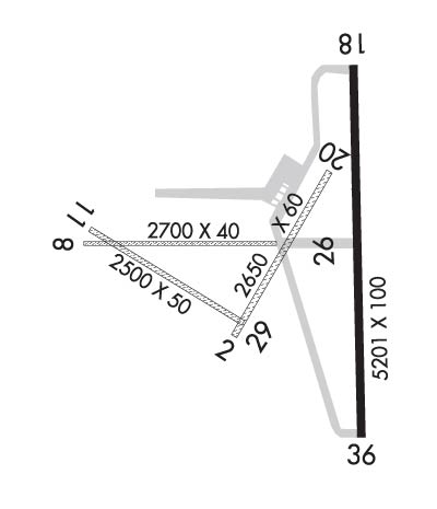
| 2650x60 | 2650' | 2650x60 | 2650' | |||||
| 2700x40 | 2700' | 2700x40 | 2700' | |||||
| 2500x50 | 2500' | 2500x50 | 2500' | |||||
| 5201x100 | 5201' | 5201x100 | 5201' | |||||
| Runway ID | Single Wheel | Double Wheel | Double Tandem Wheel | Dual Double Wheel |
| 02/20 | N/A | N/A | N/A | N/A |
| 08/26 | N/A | N/A | N/A | N/A |
| 11/29 | N/A | N/A | N/A | N/A |
| 18/36 | 30,000 | N/A | N/A | N/A |
| These numbers are Advisory and are not limits. The Airport Manager should have more accurate Weight Limits | ||||
 Airport Diagram might not be current. | |
| Facility Name: | CUSHING MUNI |
| City Name: | CUSHING |
| County: | PAYNE |
| State abbrev: | OK |
| State Name: | OKLAHOMA |
| Ownership: | PUBLICLY OWNED |
| Use: | OPEN TO THE PUBLIC |
| Owner's Name: | CITY OF CUSHING |
| Address: | PO BOX 311 |
| CUSHING, OK 74023 | |
| Owner's Phone: | 918-225-2394 |
| Manager's Name: | MIKE MIDDLETON |
| Address: | 2414 TOM MALONEY DR |
| CUSHING, OK 74023 | |
| Phone: | 918-225-0881 |
| FAA Region: | SOUTHWEST |
| FAA Field Office: | AOK |
| Date | Sunrise | Sunset |
|---|---|---|
| 06/08/26 Monday | 6:10 | 20:42 |
| 06/09/26 Tuesday | 6:10 | 20:43 |
| 06/10/26 Wednesday | 6:10 | 20:43 |
| 06/11/26 Thursday | 6:10 | 20:44 |
| 06/12/26 Friday | 6:10 | 20:44 |
| 06/13/26 Saturday | 6:10 | 20:44 |
| 06/14/26 Sunday | 6:10 | 20:45 |
| 06/15/26 Monday | 6:10 | 20:45 |
| 06/16/26 Tuesday | 6:10 | 20:46 |
| 06/17/26 Wednesday | 6:10 | 20:46 |
| 06/18/26 Thursday | 6:10 | 20:46 |
| 06/19/26 Friday | 6:10 | 20:46 |
| 06/20/26 Saturday | 6:11 | 20:47 |
| 06/21/26 Sunday | 6:11 | 20:47 |
| Airport Attendance Schedule | MON-FRI 0800-1700; UNATNDD FED HOL. |
| Airport Status | OPERATIONAL (This Status can change at any time - please check NOTAMS) |
| Airport Lighting Schedule | ACTVT REIL RWY 18 & 36 - CTAF; PAPI RWY 18 & 36 ON CONSLY; MIRL RWY 18/36 SS-SR PRESET MED INTST; INCR INTST - CTAF. |
| Airport Storage Available | Tie Downs, Hanger |
| Extra Services Available | Air Ambulance, Parachute Jumping |
| Wind Indicator | YES - (lighted) |
| Control Tower | NO |
| CTAF Frequency | 122.800 |
| Unicom Frequency | 122.800 |
| Rotating Beacon Color | WG |
| Segmented Circle | YES |
| Landing Fee | NO |
| Airport Inspected | STATE - performed by STATE AERONAUTICAL PERSONNEL |
| Inspection Date | 07/27/2023 |
| Type of Fuel Available | Grade 100LL, JET A (freeze point -40C); -10FUEL AVBL H24 WITH CREDIT CARD. |
| Airframe Repair Service | MAJOR |
| Power Plant Repair Service | MAJOR |
| Latitude | N3557.0 |
| Longitude | W09646.4 (ESTIMATED) |
| Arpt Elevation | 925ft (SURVEYED) |
| Magnetic Variation | 05E |
| 2 miles S | of CUSHING |
| Traffic Pattern Altitude | |
| Sectional Chart | DALLAS-FT WORTH |
| Operations (Reported) | Yearly | Avg. Daily |
|---|---|---|
| General Aviation Transient | 0 | 0 |
| General Aviation Local | 0 | 0 |
| Air Taxi | 0 | 0 |
| Commerical | 0 | 0 |
| Commuter | 0 | 0 |
| Military | 0 | 0 |
| Aircraft based on Field | |
|---|---|
| General Aviation Singles | 0 |
| General Aviation Multi | 0 |
| Jet Aircraft | 0 |
| General Aviation Helicopters | 0 |
| Military Aircraft | 0 |
| Gliders | 0 |
| Ultralights | 0 |
| FSS on field | NO |
| FSS tie-in | MC ALESTER |
| FSS Phone | 1-800-WX-BRIEF |
| Who issues Notams | CUH |
| Notam D service at airport | YES |
| ARTCC Name | KANSAS CITY |
| Airport Certification | |
| Aircraft Rescue & Firefighting Index | None |
| Airport of Entry | No |
| Custom Landing Rights | No |
| Joint Civil/Military | No |
| Military Landing rights | YES |
| NATIONAL PLAN OF INTEGRATED AIRPORT SYSTEMS (NPIAS) |
| GRANT AGREEMENTS UNDER FAAP/ADAP/AIP |
| ASSURANCES PURSUANT TO TITLE VI, CIVIL RIGHTS ACT OF 1964 |
| AGREEMENT UNDER DLAND OR DCLA HAS EXPIRED. |
| FOR CD CTC KANSAS CITY ARTCC AT 913-254-8508. |
| RWY 08/26 & 11/29 SOFT WHEN WET. |
Airport Communications & Frequencies:
| |||||||||
| Runway: 02 | Runway: 20 | ||
| Mag heading: | 26° | Mag heading: | 206° |
| Rwy Slope: | .53% Up | Rwy Slope: | -.53% Down |
| Approach: | Approach: | ||
| Pattern: | Left Traffic | Pattern: | Left Traffic |
| Markings: | NONSTANDARD | Markings: | NONSTANDARD |
| Marking Condition: | GOOD | Marking Condition: | GOOD |
| Arresting Dev: | Arresting Dev: | ||
| Lat & Long: | N3556.8 W09646.5 | Lat. & Long.: | N3557.2 W09646.2 |
| Elev: | 891.1 ft. MSL | Elev: | 905.1 ft. MSL |
| TCH: | TCH: | ||
| Visual Glide Path: | Visual Glide Path: | ||
| Displaced Threshold: | No | Displaced Threshold: | No |
| Touchdown Zone: | YES | Touchdown Zone: | YES |
| Touchdown Elev.: | 905.1 feet | Touchdown Elev.: | 905.1 feet |
| Visual Glide Slope: | Visual Glide Slope: | ||
| RVR Equipment: | RVR Equipment: | ||
| RVV Equipment: | NO | RVV Equipment: | NO |
| Approach Lights: | Approach Lights: | ||
| REIL: | NO | REIL: | NO |
| Centerline Lights: | NO | Centerline Lights: | NO |
| Touchdown lights: | NO | Touchdown lights: | NO |
| Runway Category: | Runway with a Visual Approach | Runway Category: | Runway with a Visual Approach |
| Declared Distances: | Declared Distances: | ||
| Obstructions: | TREES | Obstructions: | |
| Marked: | NOT Marked/Lighted | Marked: | |
| Clearance slope: | 15:1 | Clearance slope: | 20:1 |
| Obstruction height: | 35 feet AGL | Obstruction height: | |
| Dist. from runway: | 528 feet | Dist. from runway: | |
| Centerline offset: | Centerline offset: | ||
| Comments: | Comments: |
| Runway: 08 | Runway: 26 | ||
| Mag heading: | 85° | Mag heading: | 265° |
| Rwy Slope: | -.86% Down | Rwy Slope: | .86% Up |
| Approach: | Approach: | ||
| Pattern: | Left Traffic | Pattern: | Left Traffic |
| Markings: | NONSTANDARD | Markings: | NONSTANDARD |
| Marking Condition: | GOOD | Marking Condition: | GOOD |
| Arresting Dev: | Arresting Dev: | ||
| Lat & Long: | N3557.0 W09646.9 | Lat. & Long.: | N3557.0 W09646.4 |
| Elev: | 923.8 ft. MSL | Elev: | 900.6 ft. MSL |
| TCH: | TCH: | ||
| Visual Glide Path: | Visual Glide Path: | ||
| Displaced Threshold: | No | Displaced Threshold: | No |
| Touchdown Zone: | YES | Touchdown Zone: | YES |
| Touchdown Elev.: | 923.8 feet | Touchdown Elev.: | 923.8 feet |
| Visual Glide Slope: | Visual Glide Slope: | ||
| RVR Equipment: | RVR Equipment: | ||
| RVV Equipment: | NO | RVV Equipment: | NO |
| Approach Lights: | Approach Lights: | ||
| REIL: | NO | REIL: | NO |
| Centerline Lights: | NO | Centerline Lights: | NO |
| Touchdown lights: | NO | Touchdown lights: | NO |
| Runway Category: | Runway with a Visual Approach | Runway Category: | Runway with a Visual Approach |
| Declared Distances: | Declared Distances: | ||
| Obstructions: | TREES | Obstructions: | |
| Marked: | NOT Marked/Lighted | Marked: | |
| Clearance slope: | 12:1 | Clearance slope: | 20:1 |
| Obstruction height: | 32 feet AGL | Obstruction height: | |
| Dist. from runway: | 387 feet | Dist. from runway: | |
| Centerline offset: | Centerline offset: | ||
| Comments: | Comments: |
| Runway: 11 | Runway: 29 | ||
| Mag heading: | 117° | Mag heading: | 297° |
| Rwy Slope: | -1.36% Down | Rwy Slope: | 1.36% Up |
| Approach: | Approach: | ||
| Pattern: | Left Traffic | Pattern: | Left Traffic |
| Markings: | NONSTANDARD | Markings: | NONSTANDARD |
| Marking Condition: | GOOD | Marking Condition: | GOOD |
| Arresting Dev: | Arresting Dev: | ||
| Lat & Long: | N3557.1 W09646.9 | Lat. & Long.: | N3556.8 W09646.5 |
| Elev: | 925.1 ft. MSL | Elev: | 891.0 ft. MSL |
| TCH: | TCH: | ||
| Visual Glide Path: | Visual Glide Path: | ||
| Displaced Threshold: | No | Displaced Threshold: | No |
| Touchdown Zone: | YES | Touchdown Zone: | YES |
| Touchdown Elev.: | 925.1 feet | Touchdown Elev.: | 925.1 feet |
| Visual Glide Slope: | Visual Glide Slope: | ||
| RVR Equipment: | RVR Equipment: | ||
| RVV Equipment: | NO | RVV Equipment: | NO |
| Approach Lights: | Approach Lights: | ||
| REIL: | NO | REIL: | NO |
| Centerline Lights: | NO | Centerline Lights: | NO |
| Touchdown lights: | NO | Touchdown lights: | NO |
| Runway Category: | Runway with a Visual Approach | Runway Category: | Runway with a Visual Approach |
| Declared Distances: | Declared Distances: | ||
| Obstructions: | TREES | Obstructions: | |
| Marked: | NOT Marked/Lighted | Marked: | |
| Clearance slope: | 11:1 | Clearance slope: | 20:1 |
| Obstruction height: | 42 feet AGL | Obstruction height: | |
| Dist. from runway: | 475 feet | Dist. from runway: | |
| Centerline offset: | Centerline offset: | ||
| Comments: | Comments: |
| Runway: 18 | Runway: 36 | ||
| Mag heading: | 175° | Mag heading: | 355° |
| Rwy Slope: | -.72% Down | Rwy Slope: | .72% Up |
| Approach: | Approach: | ||
| Pattern: | Left Traffic | Pattern: | Left Traffic |
| Markings: | NONPRECISION INSTRUMENT | Markings: | NONPRECISION INSTRUMENT |
| Marking Condition: | FAIR | Marking Condition: | FAIR |
| Arresting Dev: | Arresting Dev: | ||
| Lat & Long: | N3557.4 W09646.2 | Lat. & Long.: | N3556.6 W09646.1 |
| Elev: | 916.0 ft. MSL | Elev: | 878.7 ft. MSL |
| TCH: | 26 ft. AGL | TCH: | 33 ft. AGL |
| Visual Glide Path: | 3.00 degrees | Visual Glide Path: | 3.00 degrees |
| Displaced Threshold: | No | Displaced Threshold: | No |
| Touchdown Zone: | YES | Touchdown Zone: | YES |
| Touchdown Elev.: | 916.0 feet | Touchdown Elev.: | 900.9 feet |
| Visual Glide Slope: | 4-Light PAPI on LEFT side of Runway | Visual Glide Slope: | 4-Light PAPI on LEFT side of Runway |
| RVR Equipment: | RVR Equipment: | ||
| RVV Equipment: | NO | RVV Equipment: | NO |
| Approach Lights: | Approach Lights: | ||
| REIL: | YES | REIL: | YES |
| Centerline Lights: | NO | Centerline Lights: | NO |
| Touchdown lights: | NO | Touchdown lights: | NO |
| Runway Category: | Runway with a Non-precision Approach having visibility minimums greater than 3/4 mile | Runway Category: | Runway with a Non-precision Approach having visibility minimums greater than 3/4 mile |
| Declared Distances: | TORA:5201' TODA:5201' ASDA:4986' LDA:4986' | Declared Distances: | TORA:5201' TODA:5201' ASDA:5201' LDA:4986' |
| Obstructions: | Obstructions: | TREES | |
| Marked: | Marked: | NOT Marked/Lighted | |
| Clearance slope: | 20:1 | Clearance slope: | 23:1 |
| Obstruction height: | Obstruction height: | 50 feet AGL | |
| Dist. from runway: | Dist. from runway: | 1373 feet | |
| Centerline offset: | Centerline offset: | 48 feet right of centerline | |
| Comments: | Comments: |
Thanks for using FltPlan.com
all rights reserved © 1999-2026 by Flight Plan LLC


