
| SAMPSON COUNTY CLINTON NC |
| |
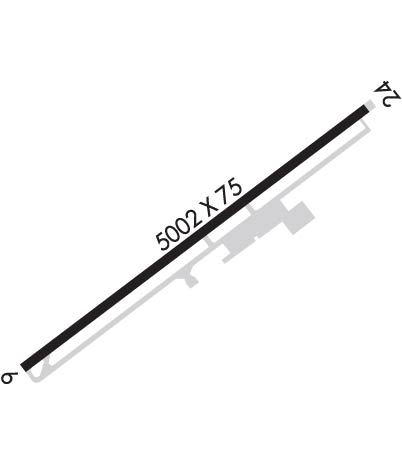
| Lat: N 3458.5 Long: W 07821.9 Elev: 144 Var: +09 Longest Runway: 5008 | ||
| AWOS: 119.12 CTAF: 122.8 | ||
| ||||||
| ||||||
|
| Rwy | Rwy | |||||||
| 5008x75 | 5008' | 109.70 - 059° | 5008x75 | 5008' | ||||
| Runway ID | Single Wheel | Double Wheel | Double Tandem Wheel | Dual Double Wheel |
| 06/24 | 26,000 | N/A | N/A | N/A |
| These numbers are Advisory and are not limits. The Airport Manager should have more accurate Weight Limits | ||||
 Airport Diagram might not be current. | |
| Facility Name: | CLINTON-SAMPSON COUNTY |
| City Name: | CLINTON |
| County: | SAMPSON |
| State abbrev: | NC |
| State Name: | NORTH CAROLINA |
| Ownership: | PUBLICLY OWNED |
| Use: | OPEN TO THE PUBLIC |
| Owner's Name: | SAMPSON COUNTY/CITY OF CLINTON |
| Address: | 221 LISBON STREET |
| CLINTON, NC 28328 | |
| Owner's Phone: | 910-592-1961 |
| Manager's Name: | TOM HART; FBO-CLINTON FLYING SERVICE - JIM NAYLOR |
| Address: | 89 SAMPSON AIRPORT ROAD |
| CLINTON, NC 28328 | |
| Phone: | 910-592-3295 |
| FAA Region: | SOUTHERN |
| FAA Field Office: | MEM |
| Date | Sunrise | Sunset |
|---|---|---|
| 09/24/21 Friday | 7:03 | 19:08 |
| 09/25/21 Saturday | 7:03 | 19:06 |
| 09/26/21 Sunday | 7:04 | 19:05 |
| 09/27/21 Monday | 7:05 | 19:03 |
| 09/28/21 Tuesday | 7:06 | 19:02 |
| 09/29/21 Wednesday | 7:06 | 19:01 |
| 09/30/21 Thursday | 7:07 | 18:59 |
| 10/01/21 Friday | 7:08 | 18:58 |
| 10/02/21 Saturday | 7:09 | 18:56 |
| 10/03/21 Sunday | 7:10 | 18:55 |
| 10/04/21 Monday | 7:10 | 18:54 |
| 10/05/21 Tuesday | 7:11 | 18:52 |
| 10/06/21 Wednesday | 7:12 | 18:51 |
| 10/07/21 Thursday | 7:13 | 18:49 |
| Airport Attendance Schedule | MON-SAT 0830-1800, SUN 1300-1800; FOR ARPT ATTENDANT AFTER HRS CALL 910-592-3295 OR 910-590-9100 |
| Airport Status | OPERATIONAL (This Status can change at any time - please check NOTAMS) |
| Airport Lighting Schedule | ACTVT REIL RYS 06 & 24 -CTAF; MIRL RY 06/24 DUSK-DAWN; PAPI RY 06 & RY 24 ON 24 HRS. |
| Airport Storage Available | Tie Downs |
| Extra Services Available | Crop Dusting, Air Ambulance, Charter, Flight Instruction, Aircraft Rental, Aircraft Sales |
| Wind Indicator | YES - (lighted) |
| Control Tower | NO |
| CTAF Frequency | 122.800 |
| Unicom Frequency | 122.800 |
| Rotating Beacon Color | CLEAR-GREEN (Light Land Airport) |
| Segmented Circle | YES |
| Landing Fee | NO |
| Airport Inspected | STATE - performed by STATE AERONAUTICAL PERSONNEL |
| Inspection Date | 07/04/2019 |
| Type of Fuel Available | Grade 100LL, JET A-1 (icing inhibitor, freeze point -50C) |
| Airframe Repair Service | MAJOR |
| Power Plant Repair Service | MAJOR |
| Latitude | N3458.5 |
| Longitude | W07821.9 (ESTIMATED) |
| Arpt Elevation | 144ft (SURVEYED) |
| Magnetic Variation | 09W |
| 2 miles SW | of CLINTON |
| Traffic Pattern Altitude | |
| Sectional Chart | CHARLOTTE |
| Operations (Reported) | Yearly | Avg. Daily |
|---|---|---|
| General Aviation Transient | 500 | 1 |
| General Aviation Local | 4000 | 11 |
| Air Taxi | 100 | 0 |
| Commerical | 0 | 0 |
| Commuter | 0 | 0 |
| Military | 600 | 2 |
| Aircraft based on Field | |
|---|---|
| General Aviation Singles | 17 |
| General Aviation Multi | 0 |
| Jet Aircraft | 1 |
| General Aviation Helicopters | 0 |
| Military Aircraft | 0 |
| Gliders | 0 |
| Ultralights | 0 |
| FSS on field | NO |
| FSS tie-in | RALEIGH |
| FSS Phone | 1-800-WX-BRIEF |
| Who issues Notams | CTZ |
| Notam D service at airport | YES |
| ARTCC Name | WASHINGTON |
| Airport Certification | |
| Aircraft Rescue & Firefighting Index | None |
| Airport of Entry | No |
| Custom Landing Rights | No |
| Joint Civil/Military | No |
| Military Landing rights | YES |
| NATIONAL PLAN OF INTEGRATED AIRPORT SYSTEMS (NPIAS) |
| GRANT AGREEMENTS UNDER FAAP/ADAP/AIP |
| ASSURANCES PURSUANT TO TITLE VI, CIVIL RIGHTS ACT OF 1964 |
| 50 FT TREES 300 FT FM CNTRLN PENETRATE TRANSITIONAL SFC NW SIDE OF RWY FM RWY 24 APCH SFC TO RWY 6 THR. |
| 40 FT DROPOFF RWY 06 325 FT FROM THR & 120 FT LEFT. 60+ FT DROPOFF 20 FT FM THR & 110 FT RIGHT OF CNTRLN. |
| 30 FT DROPOFF RWY 24 350 FT FM THR & 175 RIGHT OF CNTRLN. |
Airport Communications & Frequencies:
| ||||||||||||||
| Runway: 06 | Runway: 24 | ||
| Mag heading: | 60° | Mag heading: | 240° |
| Rwy Slope: | .28% Up | Rwy Slope: | -.28% Down |
| Approach: | LOCALIZER | Approach: | |
| Pattern: | Left Traffic | Pattern: | Left Traffic |
| Markings: | NONPRECISION INSTRUMENT | Markings: | NONPRECISION INSTRUMENT |
| Marking Condition: | GOOD | Marking Condition: | GOOD |
| Arresting Dev: | Arresting Dev: | ||
| Lat & Long: | N3458.2 W07822.3 | Lat. & Long.: | N3458.8 W07821.5 |
| Elev: | 129.8 ft. MSL | Elev: | 143.8 ft. MSL |
| TCH: | 39 ft. AGL | TCH: | 40 ft. AGL |
| Visual Glide Path: | 3.00 degrees | Visual Glide Path: | 3.00 degrees |
| Displaced Threshold: | No | Displaced Threshold: | No |
| Touchdown Zone: | YES | Touchdown Zone: | YES |
| Touchdown Elev.: | 142.2 feet | Touchdown Elev.: | 144.0 feet |
| Visual Glide Slope: | 2-Light PAPI on LEFT side of Runway | Visual Glide Slope: | 2-Light PAPI on LEFT side of Runway |
| RVR Equipment: | RVR Equipment: | ||
| RVV Equipment: | NO | RVV Equipment: | NO |
| Approach Lights: | Approach Lights: | ||
| REIL: | YES | REIL: | YES |
| Centerline Lights: | NO | Centerline Lights: | NO |
| Touchdown lights: | NO | Touchdown lights: | NO |
| Runway Category: | D | Runway Category: | Runway with a Non-precision Approach having visibility minimums greater than 3/4 mile |
| Declared Distances: | Declared Distances: | ||
| Obstructions: | TREES | Obstructions: | TREES |
| Marked: | NOT Marked/Lighted | Marked: | NOT Marked/Lighted |
| Clearance slope: | 22:1 | Clearance slope: | 1:1 |
| Obstruction height: | 47 feet AGL | Obstruction height: | 57 feet AGL |
| Dist. from runway: | 1239 feet | Dist. from runway: | 307 feet |
| Centerline offset: | 192 left of centerline | Centerline offset: | 306 feet right of centerline |
| Comments: | Comments: | HAS 79 FT TO 40 FT TREES 0-200 FT FM THLD 278 FT RIGHT OF CNTRLN AND 5 FT BRUSH 103 FT FM THLD 2 FT LEFT OF CNTRLN |
Thanks for using FltPlan.com
all rights reserved © 1999-2021 by Flight Plan LLC
