
| CROSS CITY CROSS CITY FL |
| |
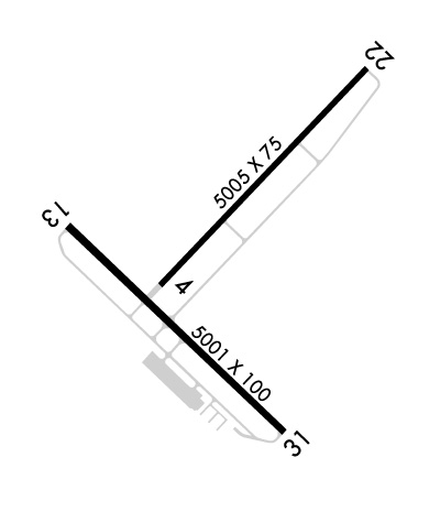
| Lat: N 2938.1 Long: W 08306.3 Elev: 42 Var: +05 Longest Runway: 5005 | ||
| CTAF: 122.8 | ||
| ||||||||||||||||||||||||||||||||||||||||||||
| ||||||||||||||||||||||||||||||||||||||||||||
| Rwy | Rwy | |||||||
| 5005x75 | 5005' | 5005x75 | 5005' | |||||
| 5001x100 | 5001' | 5001x100 | 5001' | |||||
| Runway ID | Single Wheel | Double Wheel | Double Tandem Wheel | Dual Double Wheel |
| 04/22 | 13,000 | N/A | N/A | N/A |
| 13/31 | 13,000 | N/A | N/A | N/A |
| These numbers are Advisory and are not limits. The Airport Manager should have more accurate Weight Limits | ||||
 Airport Diagram might not be current. | |
| Facility Name: | CROSS CITY |
| City Name: | CROSS CITY |
| County: | DIXIE |
| State abbrev: | FL |
| State Name: | FLORIDA |
| Ownership: | PUBLICLY OWNED |
| Use: | OPEN TO THE PUBLIC |
| Owner's Name: | DIXIE COUNTY; CONTACT PERSON: MIKE CASSIDY, 352-498-1426 FAX: 352-498-1207 |
| Address: | COUNTY COURTHOUSE P.O. BOX 2600, P.O. BOX 2600 |
| CROSS CITY, FL 32628 | |
| Owner's Phone: | 352-498-1206 |
| Manager's Name: | CLINT BEAUCHAMP; AIRPORT PHYSICAL ADDRESS: 1516 AIRPORT ROAD., CROSS CITY, FL 32628, 352-498-1200 |
| Address: | CROSS CITY AIRPORT, 508 NE 241 ST |
| CROSS CITY, FL 32628 | |
| Phone: | 352-498-6656 |
| FAA Region: | SOUTHERN |
| FAA Field Office: | ORL |
| Date | Sunrise | Sunset |
|---|---|---|
| 09/24/21 Friday | 7:22 | 19:27 |
| 09/25/21 Saturday | 7:22 | 19:26 |
| 09/26/21 Sunday | 7:23 | 19:24 |
| 09/27/21 Monday | 7:23 | 19:23 |
| 09/28/21 Tuesday | 7:24 | 19:22 |
| 09/29/21 Wednesday | 7:24 | 19:21 |
| 09/30/21 Thursday | 7:25 | 19:19 |
| 10/01/21 Friday | 7:26 | 19:18 |
| 10/02/21 Saturday | 7:26 | 19:17 |
| 10/03/21 Sunday | 7:27 | 19:16 |
| 10/04/21 Monday | 7:27 | 19:15 |
| 10/05/21 Tuesday | 7:28 | 19:13 |
| 10/06/21 Wednesday | 7:28 | 19:12 |
| 10/07/21 Thursday | 7:29 | 19:11 |
| Airport Attendance Schedule | 7 Days A Week 0800-1800 |
| Airport Status | OPERATIONAL (This Status can change at any time - please check NOTAMS) |
| Airport Lighting Schedule | ACTVT PAPI RWY 04/22, 13/31 MIRL RWY 04/22, 13/31 - CTAF. |
| Airport Storage Available | Tie Downs, Hanger |
| Extra Services Available | NONE |
| Wind Indicator | YES - (lighted) |
| Control Tower | NO |
| CTAF Frequency | 122.800 |
| Unicom Frequency | 122.800 |
| Rotating Beacon Color | CLEAR-GREEN (Light Land Airport) |
| Segmented Circle | YES |
| Landing Fee | NO |
| Airport Inspected | STATE - performed by STATE AERONAUTICAL PERSONNEL |
| Inspection Date | 04/05/2018 |
| Type of Fuel Available | Grade 100LL, JET A (freeze point -40C) |
| Airframe Repair Service | MAJOR |
| Power Plant Repair Service | MAJOR |
| Latitude | N2938.1 |
| Longitude | W08306.3 (ESTIMATED) |
| Arpt Elevation | 42ft (SURVEYED) |
| Magnetic Variation | 05W |
| 1 miles E | of CROSS CITY |
| Traffic Pattern Altitude | |
| Sectional Chart | JACKSONVILLE |
| Operations (Reported) | Yearly | Avg. Daily |
|---|---|---|
| General Aviation Transient | 14400 | 39 |
| General Aviation Local | 3600 | 10 |
| Air Taxi | 0 | 0 |
| Commerical | 0 | 0 |
| Commuter | 0 | 0 |
| Military | 0 | 0 |
| Aircraft based on Field | |
|---|---|
| General Aviation Singles | 7 |
| General Aviation Multi | 1 |
| Jet Aircraft | 2 |
| General Aviation Helicopters | 1 |
| Military Aircraft | 0 |
| Gliders | 0 |
| Ultralights | 0 |
| FSS on field | NO |
| FSS tie-in | GAINESVILLE |
| FSS Phone | 1-800-WX-BRIEF |
| Who issues Notams | GNV |
| Notam D service at airport | YES |
| ARTCC Name | JACKSONVILLE |
| Airport Certification | |
| Aircraft Rescue & Firefighting Index | None |
| Airport of Entry | No |
| Custom Landing Rights | No |
| Joint Civil/Military | No |
| Military Landing rights | YES |
| NATIONAL PLAN OF INTEGRATED AIRPORT SYSTEMS (NPIAS) |
| SURPLUS PROPERTY AGREEMENT UNDER PUBLIC LAW 289 |
| AGREEMENT UNDER DLAND OR DCLA HAS EXPIRED. |
| THIS AIRPORT HAS BEEN SURVEYED BY THE NATIONAL GEODETIC SURVEY. |
| RY 04/22 HAS TREES IN TRANSITION SFC NORTHWEST. |
| FOR CD IF UNA TO CTC ON FSS FREQ, CTC JACKSONVILLE ARTCC AT 904-845-1592. |
| RWY 13/3 1 FIRST 300 FT RWY 31 CONC. |
| RWY 04/2 2 RWY 04/22 MARKINGS DISCOLORED & NO GLASS BEADS. |
Airport Communications & Frequencies:
| |||||||||
| Runway: 04 | Runway: 22 | ||
| Mag heading: | 49° | Mag heading: | 229° |
| Rwy Slope: | -.05% Down | Rwy Slope: | .05% Up |
| Approach: | Approach: | ||
| Pattern: | Left Traffic | Pattern: | Left Traffic |
| Markings: | NONPRECISION INSTRUMENT | Markings: | NONPRECISION INSTRUMENT |
| Marking Condition: | POOR | Marking Condition: | POOR |
| Arresting Dev: | Arresting Dev: | ||
| Lat & Long: | N2938.0 W08306.5 | Lat. & Long.: | N2938.6 W08305.8 |
| Elev: | 41.7 ft. MSL | Elev: | 39.3 ft. MSL |
| TCH: | 52 ft. AGL | TCH: | 56 ft. AGL |
| Visual Glide Path: | 3.00 degrees | Visual Glide Path: | 3.00 degrees |
| Displaced Threshold: | No | Displaced Threshold: | No |
| Touchdown Zone: | YES | Touchdown Zone: | YES |
| Touchdown Elev.: | 41.9 feet | Touchdown Elev.: | 42.1 feet |
| Visual Glide Slope: | 2-Light PAPI on LEFT side of Runway | Visual Glide Slope: | 2-Light PAPI on LEFT side of Runway |
| RVR Equipment: | RVR Equipment: | ||
| RVV Equipment: | NO | RVV Equipment: | NO |
| Approach Lights: | Approach Lights: | ||
| REIL: | NO | REIL: | NO |
| Centerline Lights: | NO | Centerline Lights: | NO |
| Touchdown lights: | NO | Touchdown lights: | NO |
| Runway Category: | Runway with a Visual Approach | Runway Category: | Runway with a Visual Approach |
| Declared Distances: | Declared Distances: | ||
| Obstructions: | TREES | Obstructions: | TREES |
| Marked: | NOT Marked/Lighted | Marked: | NOT Marked/Lighted |
| Clearance slope: | 21:1 | Clearance slope: | 17:1 |
| Obstruction height: | 55 feet AGL | Obstruction height: | 63 feet AGL |
| Dist. from runway: | 1355 feet | Dist. from runway: | 1270 feet |
| Centerline offset: | 150 right of centerline | Centerline offset: | 60 feet left of centerline |
| Comments: | Comments: |
| Runway: 13 | Runway: 31 | ||
| Mag heading: | 139° | Mag heading: | 319° |
| Rwy Slope: | -.01% Down | Rwy Slope: | .01% Up |
| Approach: | Approach: | ||
| Pattern: | Left Traffic | Pattern: | Left Traffic |
| Markings: | NONPRECISION INSTRUMENT | Markings: | NONPRECISION INSTRUMENT |
| Marking Condition: | FAIR | Marking Condition: | FAIR |
| Arresting Dev: | Arresting Dev: | ||
| Lat & Long: | N2938.2 W08306.8 | Lat. & Long.: | N2937.6 W08306.1 |
| Elev: | 41.0 ft. MSL | Elev: | 40.6 ft. MSL |
| TCH: | 37 ft. AGL | TCH: | 36 ft. AGL |
| Visual Glide Path: | 3.00 degrees | Visual Glide Path: | 3.00 degrees |
| Displaced Threshold: | No | Displaced Threshold: | No |
| Touchdown Zone: | YES | Touchdown Zone: | YES |
| Touchdown Elev.: | 41.9 feet | Touchdown Elev.: | 41.8 feet |
| Visual Glide Slope: | 2-Light PAPI on LEFT side of Runway | Visual Glide Slope: | 2-Light PAPI on LEFT side of Runway |
| RVR Equipment: | RVR Equipment: | ||
| RVV Equipment: | NO | RVV Equipment: | NO |
| Approach Lights: | Approach Lights: | ||
| REIL: | YES | REIL: | YES |
| Centerline Lights: | NO | Centerline Lights: | NO |
| Touchdown lights: | NO | Touchdown lights: | NO |
| Runway Category: | Runway with a Visual Approach | Runway Category: | Runway with a Non-precision Approach having visibility minimums greater than 3/4 mile |
| Declared Distances: | Declared Distances: | ||
| Obstructions: | TREES | Obstructions: | TREES |
| Marked: | NOT Marked/Lighted | Marked: | NOT Marked/Lighted |
| Clearance slope: | 22:1 | Clearance slope: | |
| Obstruction height: | 56 feet AGL | Obstruction height: | 20 feet AGL |
| Dist. from runway: | 1430 feet | Dist. from runway: | 200 feet |
| Centerline offset: | 250 right of centerline | Centerline offset: | 250 feet left of centerline |
| Comments: | Comments: | RWY 31 TREES 160 FT - 200 FT FROM THE RWY END 250 FT LEFT OF CNTRLN. |
Thanks for using FltPlan.com
all rights reserved © 1999-2021 by Flight Plan LLC
