| INGERSOLL CANTON IL |
| |
| Lat: N 4034.1 Long: W 09004.5 Elev: 684 Var: -02 Longest Runway: 3899 | ||
| AWOS: 122.8 CTAF: 122.8 | ||
| |||||||||||||||||||||||||||||||||||||||||||||||||||||||||||||
| |||||||||||||||||||||||||||||||||||||||||||||||||||||||||||||
| |||||||||||||||||||||||||||||||||||||||||||||||||||||||||||||
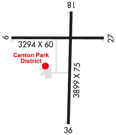
| Rwy | Rwy | |||||||
| 3294x60 | 3294' | 3294x60 | 3294' | |||||
| 3899x75 | 3899' | 3899x75 | 3899' | |||||
| Runway ID | Single Wheel | Double Wheel | Double Tandem Wheel | Dual Double Wheel |
| 09/27 | 11,000 | N/A | N/A | N/A |
| 18/36 | 10,000 | N/A | N/A | N/A |
| These numbers are Advisory and are not limits. The Airport Manager should have more accurate Weight Limits | ||||
 Airport Diagram might not be current. | |
| Facility Name: | INGERSOLL |
| City Name: | CANTON |
| County: | FULTON |
| State abbrev: | IL |
| State Name: | ILLINOIS |
| Ownership: | PUBLICLY OWNED |
| Use: | OPEN TO THE PUBLIC |
| Owner's Name: | CANTON PARK DISTRICT |
| Address: | 250 S AVE D |
| CANTON, IL 61520 | |
| Owner's Phone: | 309-647-1345 |
| Manager's Name: | JON JOHNSON |
| Address: | 250 S AVE D; EMAIL ADDRESS: CPD_JOHNSON@SBCGLOBAL.NET (ALL LOWER CASE) |
| CANTON, IL 61520 | |
| Phone: | 309-647-1345 |
| FAA Region: | GREAT LAKES |
| FAA Field Office: | CHI |
| Date | Sunrise | Sunset |
|---|---|---|
| 09/24/21 Friday | 6:50 | 18:54 |
| 09/25/21 Saturday | 6:51 | 18:53 |
| 09/26/21 Sunday | 6:52 | 18:51 |
| 09/27/21 Monday | 6:53 | 18:49 |
| 09/28/21 Tuesday | 6:54 | 18:48 |
| 09/29/21 Wednesday | 6:55 | 18:46 |
| 09/30/21 Thursday | 6:56 | 18:44 |
| 10/01/21 Friday | 6:57 | 18:43 |
| 10/02/21 Saturday | 6:58 | 18:41 |
| 10/03/21 Sunday | 6:59 | 18:39 |
| 10/04/21 Monday | 7:00 | 18:38 |
| 10/05/21 Tuesday | 7:01 | 18:36 |
| 10/06/21 Wednesday | 7:02 | 18:35 |
| 10/07/21 Thursday | 7:03 | 18:33 |
| Airport Attendance Schedule | 7 Days A Week 0700-DUSK |
| Airport Status | OPERATIONAL (This Status can change at any time - please check NOTAMS) |
| Airport Lighting Schedule | ACTVT MIRL RYS 09/27 & 18/36 & REIL RY 36 & TWY LGTS - 7 CLICKS ON CTAF. |
| Airport Storage Available | Tie Downs |
| Extra Services Available | Flight Instruction, Aircraft Rental |
| Wind Indicator | YES - (lighted) |
| Control Tower | NO |
| CTAF Frequency | 122.800 |
| Unicom Frequency | 122.800 |
| Rotating Beacon Color | CLEAR-GREEN (Light Land Airport) |
| Segmented Circle | YES |
| Landing Fee | NO |
| Airport Inspected | STATE - performed by STATE AERONAUTICAL PERSONNEL |
| Inspection Date | 06/10/2021 |
| Type of Fuel Available | Grade 100LL; -10SELF-SERV FUELING |
| Airframe Repair Service | MAJOR |
| Power Plant Repair Service | MAJOR |
| Latitude | N4034.1 |
| Longitude | W09004.5 (ESTIMATED) |
| Arpt Elevation | 683ft (SURVEYED) |
| Magnetic Variation | 02E |
| 2 miles NW | of CANTON |
| Traffic Pattern Altitude | 800 |
| Sectional Chart | CHICAGO |
| Operations (Reported) | Yearly | Avg. Daily |
|---|---|---|
| General Aviation Transient | 2000 | 5 |
| General Aviation Local | 17000 | 47 |
| Air Taxi | 0 | 0 |
| Commerical | 0 | 0 |
| Commuter | 0 | 0 |
| Military | 0 | 0 |
| Aircraft based on Field | |
|---|---|
| General Aviation Singles | 17 |
| General Aviation Multi | 1 |
| Jet Aircraft | 0 |
| General Aviation Helicopters | 0 |
| Military Aircraft | 0 |
| Gliders | 0 |
| Ultralights | 0 |
| FSS on field | NO |
| FSS tie-in | KANKAKEE |
| FSS Phone | 1-800-WX-BRIEF |
| Who issues Notams | IKK |
| Notam D service at airport | YES |
| ARTCC Name | CHICAGO |
| Airport Certification | |
| Aircraft Rescue & Firefighting Index | None |
| Airport of Entry | No |
| Custom Landing Rights | No |
| Joint Civil/Military | No |
| Military Landing rights | YES |
| NATIONAL PLAN OF INTEGRATED AIRPORT SYSTEMS (NPIAS) |
| GRANT AGREEMENTS UNDER FAAP/ADAP/AIP |
| ASSURANCES PURSUANT TO TITLE VI, CIVIL RIGHTS ACT OF 1964 |
| AWOS (DIGIWX) ACTVT 8 MIC CLICKS ON CTAF. |
| FOR CD CTC PEORIA APCH AT 309-697-0752, EXT 210. |
Airport Communications & Frequencies:
| ||||||||||||||
| Runway: 09 | Runway: 27 | ||
| Mag heading: | 87° | Mag heading: | 267° |
| Rwy Slope: | -.06% Down | Rwy Slope: | .06% Up |
| Approach: | Approach: | ||
| Pattern: | Left Traffic | Pattern: | Left Traffic |
| Markings: | BASIC | Markings: | BASIC |
| Marking Condition: | FAIR | Marking Condition: | FAIR |
| Arresting Dev: | Arresting Dev: | ||
| Lat & Long: | N4034.2 W09004.9 | Lat. & Long.: | N4034.2 W09004.2 |
| Elev: | 683.8 ft. MSL | Elev: | 681.8 ft. MSL |
| TCH: | TCH: | ||
| Visual Glide Path: | Visual Glide Path: | ||
| Displaced Threshold: | No | Displaced Threshold: | No |
| Touchdown Zone: | YES | Touchdown Zone: | YES |
| Touchdown Elev.: | 683.9 feet | Touchdown Elev.: | 683.4 feet |
| Visual Glide Slope: | Visual Glide Slope: | ||
| RVR Equipment: | RVR Equipment: | ||
| RVV Equipment: | NO | RVV Equipment: | NO |
| Approach Lights: | Approach Lights: | ||
| REIL: | NO | REIL: | NO |
| Centerline Lights: | NO | Centerline Lights: | NO |
| Touchdown lights: | NO | Touchdown lights: | NO |
| Runway Category: | Runway with a Visual Approach | Runway Category: | Runway with a Visual Approach |
| Declared Distances: | Declared Distances: | ||
| Obstructions: | Obstructions: | TREES | |
| Marked: | Marked: | NOT Marked/Lighted | |
| Clearance slope: | 20:1 | Clearance slope: | 14:1 |
| Obstruction height: | Obstruction height: | 30 feet AGL | |
| Dist. from runway: | Dist. from runway: | 630 feet | |
| Centerline offset: | Centerline offset: | 110 feet left of centerline | |
| Comments: | Comments: |
| Runway: 18 | Runway: 36 | ||
| Mag heading: | 179° | Mag heading: | 359° |
| Rwy Slope: | -.30% Down | Rwy Slope: | .30% Up |
| Approach: | Approach: | ||
| Pattern: | Left Traffic | Pattern: | Left Traffic |
| Markings: | NONPRECISION INSTRUMENT | Markings: | NONPRECISION INSTRUMENT |
| Marking Condition: | FAIR | Marking Condition: | FAIR |
| Arresting Dev: | Arresting Dev: | ||
| Lat & Long: | N4034.4 W09004.4 | Lat. & Long.: | N4033.7 W09004.4 |
| Elev: | 681.9 ft. MSL | Elev: | 670.3 ft. MSL |
| TCH: | TCH: | ||
| Visual Glide Path: | Visual Glide Path: | ||
| Displaced Threshold: | No | Displaced Threshold: | No |
| Touchdown Zone: | YES | Touchdown Zone: | YES |
| Touchdown Elev.: | 682.1 feet | Touchdown Elev.: | 679.6 feet |
| Visual Glide Slope: | Visual Glide Slope: | ||
| RVR Equipment: | RVR Equipment: | ||
| RVV Equipment: | NO | RVV Equipment: | NO |
| Approach Lights: | Approach Lights: | ||
| REIL: | NO | REIL: | YES |
| Centerline Lights: | NO | Centerline Lights: | NO |
| Touchdown lights: | NO | Touchdown lights: | NO |
| Runway Category: | Runway with a Non-precision Approach | Runway Category: | Runway with a Non-precision Approach |
| Declared Distances: | Declared Distances: |
Thanks for using FltPlan.com
all rights reserved © 1999-2021 by Flight Plan LLC