
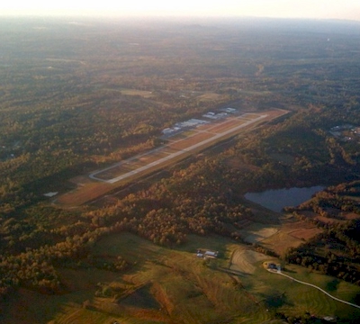
| WEST GEORGIA RGNL - O V GRAY CARROLLTON GA |
| |
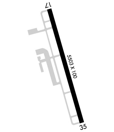
| Lat: N 3337.9 Long: W 08509.1 Elev: 1165 Var: +04 Longest Runway: 5503 | ||
| Clr Del: 121.6 AWOS: 118.17 CTAF: 122.97 | ||
| |||||||||||||||||||||||||||||||||||||||||||||||||||||||||||||||||||||
| |||||||||||||||||||||||||||||||||||||||||||||||||||||||||||||||||||||
| |||||||||||||||||||||||||||||||||||||||||||||||||||||||||||||||||||||
| Rwy | Rwy | |||||||
| 5503x100 | 5503' | 5503x100 | 5503' | 111.70 - 347° | ||||
| Runway ID | Single Wheel | Double Wheel | Double Tandem Wheel | Dual Double Wheel |
| 17/35 | 43,000 | 56,000 | 83,000 | N/A |
| These numbers are Advisory and are not limits. The Airport Manager should have more accurate Weight Limits | ||||
 Airport Diagram might not be current. | |
| Facility Name: | WEST GEORGIA RGNL/O V GRAY FLD |
| City Name: | CARROLLTON |
| County: | CARROLL |
| State abbrev: | GA |
| State Name: | GEORGIA |
| Ownership: | PUBLICLY OWNED |
| Use: | OPEN TO THE PUBLIC |
| Owner's Name: | WEST GA ARPT AUTH |
| Address: | 635 REGIONAL AIRPORT ROAD |
| CARROLLTON, GA 30117 | |
| Owner's Phone: | 770-354-5927 |
| Manager's Name: | MARK WEINSTEIN |
| Address: | 635 REGIONAL AIRPORT ROAD |
| CARROLLTON, GA 30117 | |
| Phone: | 470-431-0024 |
| FAA Region: | SOUTHERN |
| FAA Field Office: | ATL |
| Date | Sunrise | Sunset |
|---|---|---|
| 06/08/26 Monday | 6:30 | 20:49 |
| 06/09/26 Tuesday | 6:30 | 20:50 |
| 06/10/26 Wednesday | 6:30 | 20:50 |
| 06/11/26 Thursday | 6:30 | 20:51 |
| 06/12/26 Friday | 6:30 | 20:51 |
| 06/13/26 Saturday | 6:30 | 20:52 |
| 06/14/26 Sunday | 6:30 | 20:52 |
| 06/15/26 Monday | 6:30 | 20:52 |
| 06/16/26 Tuesday | 6:30 | 20:53 |
| 06/17/26 Wednesday | 6:30 | 20:53 |
| 06/18/26 Thursday | 6:30 | 20:53 |
| 06/19/26 Friday | 6:30 | 20:54 |
| 06/20/26 Saturday | 6:30 | 20:54 |
| 06/21/26 Sunday | 6:31 | 20:54 |
| Airport Attendance Schedule | 7 Days A Week 0800-1800 |
| Airport Status | OPERATIONAL (This Status can change at any time - please check NOTAMS) |
| Airport Lighting Schedule | HIRL RWY 17/35 PRESET LOW INTST DUSK-2200, AFT 2200 ACTVT - CTAF. PAPI RWYS 17 & 35 - CTAF. |
| Airport Storage Available | Tie Downs, Hanger |
| Extra Services Available | Avionics, Flight Instruction, Aircraft Rental |
| Wind Indicator | YES - (lighted) |
| Control Tower | NO |
| CTAF Frequency | 122.975 |
| Unicom Frequency | 122.975 |
| Rotating Beacon Color | WG |
| Segmented Circle | YES |
| Landing Fee | NO |
| Airport Inspected | STATE - performed by STATE AERONAUTICAL PERSONNEL |
| Inspection Date | 04/23/2026 |
| Type of Fuel Available | Grade 100LL, JET A |
| Airframe Repair Service | MAJOR |
| Power Plant Repair Service | MAJOR |
| Latitude | N3337.9 |
| Longitude | W08509.1 (ESTIMATED) |
| Arpt Elevation | 1164ft (SURVEYED) |
| Magnetic Variation | 04W |
| 5 miles NW | of CARROLLTON |
| Traffic Pattern Altitude | |
| Sectional Chart | ATLANTA |
| Operations (Reported) | Yearly | Avg. Daily |
|---|---|---|
| General Aviation Transient | 0 | 0 |
| General Aviation Local | 0 | 0 |
| Air Taxi | 0 | 0 |
| Commerical | 0 | 0 |
| Commuter | 0 | 0 |
| Military | 0 | 0 |
| Aircraft based on Field | |
|---|---|
| General Aviation Singles | 0 |
| General Aviation Multi | 0 |
| Jet Aircraft | 0 |
| General Aviation Helicopters | 0 |
| Military Aircraft | 0 |
| Gliders | 0 |
| Ultralights | 0 |
| FSS on field | NO |
| FSS tie-in | MACON |
| FSS Phone | 1-800-WX-BRIEF |
| Who issues Notams | MCN |
| Notam D service at airport | YES |
| ARTCC Name | ATLANTA |
| Airport Certification | |
| Aircraft Rescue & Firefighting Index | None |
| Airport of Entry | No |
| Custom Landing Rights | No |
| Joint Civil/Military | No |
| Military Landing rights | YES |
| NATIONAL PLAN OF INTEGRATED AIRPORT SYSTEMS (NPIAS) |
| GRANT AGREEMENTS UNDER FAAP/ADAP/AIP |
| ASSURANCES PURSUANT TO TITLE VI, CIVIL RIGHTS ACT OF 1964 |
| DEER AND TURKEYS ON & NEAR RWYS AT ALL TIMES. |
| FOR APCH/DEP SVC CTC ATLANTA APCH AT 678-364-6131. IF RLS TIME IS EXPD TO BE LESS THAN 5 MINS, CTC CD. |
Airport Communications & Frequencies:
| ||||||||||||||||
| Runway: 17 | Runway: 35 | ||
| Mag heading: | 168° | Mag heading: | 348° |
| Rwy Slope: | -.98% Down | Rwy Slope: | .98% Up |
| Approach: | Approach: | LOC/GS | |
| Pattern: | Left Traffic | Pattern: | Left Traffic |
| Markings: | NONPRECISION INSTRUMENT | Markings: | PRECISION INSTRUMENT |
| Marking Condition: | GOOD | Marking Condition: | GOOD |
| Arresting Dev: | Arresting Dev: | ||
| Lat & Long: | N3338.3 W08509.3 | Lat. & Long.: | N3337.5 W08509.0 |
| Elev: | 1164.6 ft. MSL | Elev: | 1110.5 ft. MSL |
| TCH: | 56 ft. AGL | TCH: | 54 ft. AGL |
| Visual Glide Path: | 3.00 degrees | Visual Glide Path: | 3.00 degrees |
| Displaced Threshold: | No | Displaced Threshold: | No |
| Touchdown Zone: | YES | Touchdown Zone: | YES |
| Touchdown Elev.: | 1164.6 feet | Touchdown Elev.: | 1140.4 feet |
| Visual Glide Slope: | 4-Light PAPI on LEFT side of Runway | Visual Glide Slope: | 4-Light PAPI on LEFT side of Runway |
| RVR Equipment: | RVR Equipment: | ||
| RVV Equipment: | NO | RVV Equipment: | NO |
| Approach Lights: | Approach Lights: | ||
| REIL: | NO | REIL: | NO |
| Centerline Lights: | NO | Centerline Lights: | NO |
| Touchdown lights: | NO | Touchdown lights: | NO |
| Runway Category: | Runway with a Non-precision Approach having visibility minimums greater than 3/4 mile | Runway Category: | Precision Instrument Runway |
| Declared Distances: | Declared Distances: | ||
| Obstructions: | TREES | Obstructions: | TREES |
| Marked: | NOT Marked/Lighted | Marked: | NOT Marked/Lighted |
| Clearance slope: | 23:1 | Clearance slope: | 22:1 |
| Obstruction height: | 92 feet AGL | Obstruction height: | 34 feet AGL |
| Dist. from runway: | 2341 feet | Dist. from runway: | 948 feet |
| Centerline offset: | 401 left of centerline | Centerline offset: | 575 feet right of centerline |
| Comments: | Comments: |
Thanks for using FltPlan.com
all rights reserved © 1999-2026 by Flight Plan LLC


