
| CRESTON MUNI CRESTON IA |
| |
| Lat: N 4101.3 Long: W 09421.8 Elev: 1300 Var: -04 Longest Runway: 4901 | ||
| AWOS: 124.75 CTAF: 122.8 | ||
| ||||||
| ||||||
|
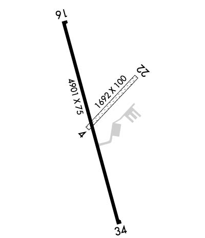
| Rwy | Rwy | |||||||
| 1692x100 | 1692' | 1692x100 | 1692' | |||||
| 4901x75 | 4901' | 4901x75 | 4901' | |||||
| Runway ID | Single Wheel | Double Wheel | Double Tandem Wheel | Dual Double Wheel |
| 04/22 | N/A | N/A | N/A | N/A |
| 16/34 | 15,000 | N/A | N/A | N/A |
| These numbers are Advisory and are not limits. The Airport Manager should have more accurate Weight Limits | ||||
 Airport Diagram might not be current. | |
| Facility Name: | CRESTON MUNI |
| City Name: | CRESTON |
| County: | UNION |
| State abbrev: | IA |
| State Name: | IOWA |
| Ownership: | PUBLICLY OWNED |
| Use: | OPEN TO THE PUBLIC |
| Owner's Name: | CITY OF CRESTON; TADD CARR |
| Address: | 116 W. ADAMS |
| CRESTON, IA 50801 | |
| Owner's Phone: | 641-782-2000 |
| Manager's Name: | TYLER WEST |
| Address: | 1945 CHERRY STREET ROAD |
| CRESTON, IA 50801 | |
| Phone: | 641-278-0203; 641-782-2383 |
| FAA Region: | CENTRAL |
| FAA Field Office: | NONE |
| Date | Sunrise | Sunset |
|---|---|---|
| 06/08/26 Monday | 5:45 | 20:48 |
| 06/09/26 Tuesday | 5:45 | 20:48 |
| 06/10/26 Wednesday | 5:45 | 20:49 |
| 06/11/26 Thursday | 5:45 | 20:50 |
| 06/12/26 Friday | 5:45 | 20:50 |
| 06/13/26 Saturday | 5:45 | 20:50 |
| 06/14/26 Sunday | 5:45 | 20:51 |
| 06/15/26 Monday | 5:45 | 20:51 |
| 06/16/26 Tuesday | 5:45 | 20:52 |
| 06/17/26 Wednesday | 5:45 | 20:52 |
| 06/18/26 Thursday | 5:45 | 20:52 |
| 06/19/26 Friday | 5:45 | 20:53 |
| 06/20/26 Saturday | 5:45 | 20:53 |
| 06/21/26 Sunday | 5:45 | 20:53 |
| Airport Attendance Schedule | MON-FRI 0800-1700, SAT-SUN ON CALL |
| Airport Status | OPERATIONAL (This Status can change at any time - please check NOTAMS) |
| Airport Lighting Schedule | ACTVT REIL RWY 16 & 34; PAPI RWY 16 & 34; MIRL RWY 16/34 - CTAF. MIRL RWY 16/34 PRESET LOW INTST; INCR INTST - CTAF. |
| Airport Storage Available | Tie Downs, Hanger |
| Extra Services Available | NONE |
| Wind Indicator | YES - (lighted) |
| Control Tower | NO |
| CTAF Frequency | 122.800 |
| Unicom Frequency | 122.800 |
| Rotating Beacon Color | WG |
| Segmented Circle | NO |
| Landing Fee | NO |
| Airport Inspected | STATE - performed by STATE AERONAUTICAL PERSONNEL |
| Inspection Date | 07/24/2024 |
| Type of Fuel Available | Grade 100LL, JET A (freeze point -40C) |
| Airframe Repair Service | MINOR |
| Power Plant Repair Service | MINOR |
| Latitude | N4101.3 |
| Longitude | W09421.8 (ESTIMATED) |
| Arpt Elevation | 1299ft (SURVEYED) |
| Magnetic Variation | 04E |
| 3 miles S | of CRESTON |
| Traffic Pattern Altitude | |
| Sectional Chart | OMAHA |
| Operations (Reported) | Yearly | Avg. Daily |
|---|---|---|
| General Aviation Transient | 0 | 0 |
| General Aviation Local | 0 | 0 |
| Air Taxi | 0 | 0 |
| Commerical | 0 | 0 |
| Commuter | 0 | 0 |
| Military | 0 | 0 |
| Aircraft based on Field | |
|---|---|
| General Aviation Singles | 0 |
| General Aviation Multi | 0 |
| Jet Aircraft | 0 |
| General Aviation Helicopters | 0 |
| Military Aircraft | 0 |
| Gliders | 0 |
| Ultralights | 0 |
| FSS on field | NO |
| FSS tie-in | FORT DODGE |
| FSS Phone | 1-800-WX-BRIEF |
| Who issues Notams | CSQ |
| Notam D service at airport | YES |
| ARTCC Name | MINNEAPOLIS |
| Airport Certification | |
| Aircraft Rescue & Firefighting Index | None |
| Airport of Entry | No |
| Custom Landing Rights | No |
| Joint Civil/Military | No |
| Military Landing rights | YES |
| NATIONAL PLAN OF INTEGRATED AIRPORT SYSTEMS (NPIAS) |
| GRANT AGREEMENTS UNDER FAAP/ADAP/AIP |
| ASSURANCES PURSUANT TO TITLE VI, CIVIL RIGHTS ACT OF 1964 |
| THIS AIRPORT HAS BEEN SURVEYED BY THE NATIONAL GEODETIC SURVEY. |
| REMOTE CTL OPS INVOF ARPT. |
| FOR CD CTC MINNEAPOLIS ARTCC AT 651-463-5588. |
| RWY 04/2 2 CLSD DURG WINTER. |
| RWY 04 SHARP DROP AT RWY END. |
Airport Communications & Frequencies:
| |||||||||
| Runway: 04 | Runway: 22 | ||
| Mag heading: | 41° | Mag heading: | 221° |
| Approach: | Approach: | ||
| Pattern: | Left Traffic | Pattern: | Left Traffic |
| Markings: | Markings: | ||
| Marking Condition: | YELLOW CONES. | Marking Condition: | YELLOW CONES. |
| Arresting Dev: | Arresting Dev: | ||
| Lat & Long: | N4101.2 W09421.8 | Lat. & Long.: | N4101.4 W09421.6 |
| Elev: | N/A | Elev: | 1299.7 ft. MSL |
| TCH: | TCH: | ||
| Visual Glide Path: | Visual Glide Path: | ||
| Displaced Threshold: | No | Displaced Threshold: | No |
| Touchdown Zone: | NO | Touchdown Zone: | NO |
| Touchdown Elev.: | Touchdown Elev.: | ||
| Visual Glide Slope: | Visual Glide Slope: | ||
| RVR Equipment: | RVR Equipment: | ||
| RVV Equipment: | NO | RVV Equipment: | NO |
| Approach Lights: | Approach Lights: | ||
| REIL: | NO | REIL: | NO |
| Centerline Lights: | NO | Centerline Lights: | NO |
| Touchdown lights: | NO | Touchdown lights: | NO |
| Runway Category: | Runway with a Visual Approach | Runway Category: | Runway with a Visual Approach |
| Declared Distances: | Declared Distances: |
| Runway: 16 | Runway: 34 | ||
| Mag heading: | 161° | Mag heading: | 341° |
| Rwy Slope: | .13% Up | Rwy Slope: | -.13% Down |
| Approach: | Approach: | ||
| Pattern: | Left Traffic | Pattern: | Left Traffic |
| Markings: | NONPRECISION INSTRUMENT | Markings: | NONPRECISION INSTRUMENT |
| Marking Condition: | GOOD | Marking Condition: | GOOD |
| Arresting Dev: | Arresting Dev: | ||
| Lat & Long: | N4101.7 W09422.0 | Lat. & Long.: | N4100.9 W09421.7 |
| Elev: | 1288.6 ft. MSL | Elev: | 1294.9 ft. MSL |
| TCH: | 44 ft. AGL | TCH: | 44 ft. AGL |
| Visual Glide Path: | 3.00 degrees | Visual Glide Path: | 3.00 degrees |
| Displaced Threshold: | No | Displaced Threshold: | No |
| Touchdown Zone: | YES | Touchdown Zone: | YES |
| Touchdown Elev.: | 1295.7 feet | Touchdown Elev.: | 1296.0 feet |
| Visual Glide Slope: | 2-Light PAPI on LEFT side of Runway | Visual Glide Slope: | 2-Light PAPI on LEFT side of Runway |
| RVR Equipment: | RVR Equipment: | ||
| RVV Equipment: | NO | RVV Equipment: | NO |
| Approach Lights: | Approach Lights: | ||
| REIL: | YES | REIL: | YES |
| Centerline Lights: | NO | Centerline Lights: | NO |
| Touchdown lights: | NO | Touchdown lights: | NO |
| Runway Category: | Runway with a Non-precision Approach having visibility minimums greater than 3/4 mile | Runway Category: | Runway with a Non-precision Approach having visibility minimums greater than 3/4 mile |
| Declared Distances: | Declared Distances: | ||
| Obstructions: | FENCE | Obstructions: | TREE |
| Marked: | NOT Marked/Lighted | Marked: | LIGHTED |
| Clearance slope: | 24:1 | Clearance slope: | 25:1 |
| Obstruction height: | 13 feet AGL | Obstruction height: | 5 feet AGL |
| Dist. from runway: | 520 feet | Dist. from runway: | 326 feet |
| Centerline offset: | Centerline offset: | 135 feet right of centerline | |
| Comments: | Comments: |
Thanks for using FltPlan.com
all rights reserved © 1999-2026 by Flight Plan LLC
