
| YEAGER CHARLESTON WV |
| |
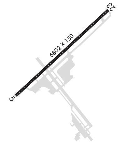
| Lat: N 3822.6 Long: W 08135.6 Elev: 947 Var: +06 Longest Runway: 6715 | ||
| Clr Del: 118.55 Dept. ATIS: 127.6 Arr. ATIS: 127.6 Ground: 121.8 Tower: 125.7 | ||
| ||||||||||||||||||||||||||||||||||||||||||||
| ||||||||||||||||||||||||||||||||||||||||||||
| ||||||||||||||||||||||||||||||||||||||||||||
| Rwy | Rwy | |||||||
| 6715x150 | 6715' | 110.30 - 051° | 6715x150 | 6215' | 110.30 - 234° | |||
| Runway ID | Single Wheel | Double Wheel | Double Tandem Wheel | Dual Double Wheel |
| 05/23 | 120,000 | 160,000 | 260,000 | N/A |
| These numbers are Advisory and are not limits. The Airport Manager should have more accurate Weight Limits | ||||
 Airport Diagram might not be current. | |
| Facility Name: | YEAGER |
| City Name: | CHARLESTON |
| County: | KANAWHA |
| State abbrev: | WV |
| State Name: | WEST VIRGINIA |
| Ownership: | PUBLICLY OWNED |
| Use: | OPEN TO THE PUBLIC |
| Owner's Name: | CENTRAL WV REG ARPT AUTH |
| Address: | 100 AIRPORT ROAD SUITE 175 |
| CHARLESTON, WV 25311 | |
| Owner's Phone: | (304) 344-8033 |
| Manager's Name: | NICK KELLER |
| Address: | 100 AIRPORT ROAD SUITE 175 |
| CHARLESTON, WV 25311 | |
| Phone: | 304-344-8033 |
| FAA Region: | EASTERN |
| FAA Field Office: | BKW |
| Date | Sunrise | Sunset |
|---|---|---|
| 09/24/21 Friday | 7:16 | 19:21 |
| 09/25/21 Saturday | 7:16 | 19:19 |
| 09/26/21 Sunday | 7:17 | 19:17 |
| 09/27/21 Monday | 7:18 | 19:16 |
| 09/28/21 Tuesday | 7:19 | 19:14 |
| 09/29/21 Wednesday | 7:20 | 19:13 |
| 09/30/21 Thursday | 7:21 | 19:11 |
| 10/01/21 Friday | 7:22 | 19:10 |
| 10/02/21 Saturday | 7:23 | 19:08 |
| 10/03/21 Sunday | 7:24 | 19:07 |
| 10/04/21 Monday | 7:25 | 19:05 |
| 10/05/21 Tuesday | 7:26 | 19:03 |
| 10/06/21 Wednesday | 7:26 | 19:02 |
| 10/07/21 Thursday | 7:27 | 19:00 |
| Airport Attendance Schedule | CONTINUOUS |
| Airport Status | OPERATIONAL (This Status can change at any time - please check NOTAMS) |
| Airport Lighting Schedule | |
| Airport Storage Available | Tie Downs, Hanger |
| Extra Services Available | Air Ambulance, Cargo Handling, Charter, Flight Instruction, Aircraft Rental, Aircraft Sales |
| Wind Indicator | YES - (lighted) |
| Control Tower | YES |
| CTAF Frequency | |
| Unicom Frequency | 122.950 |
| Rotating Beacon Color | CLEAR-GREEN (Light Land Airport) |
| Segmented Circle | NO |
| Landing Fee | YES; LNDG FEE NOT APPLICABLE TO BASED ACFT. |
| Airport Inspected | FEDERAL - performed by FAA AIRPORTS FIELD PERSONNEL |
| Inspection Date | 10/15/2019 |
| Type of Fuel Available | Grade 100LL, JET A (freeze point -40C) |
| Airframe Repair Service | MAJOR |
| Power Plant Repair Service | MAJOR |
| Latitude | N3822.6 |
| Longitude | W08135.6 (ESTIMATED) |
| Arpt Elevation | 947ft (SURVEYED) |
| Magnetic Variation | 06W |
| 3 miles E | of CHARLESTON |
| Traffic Pattern Altitude | |
| Sectional Chart | CINCINNATI |
| Operations (Reported) | Yearly | Avg. Daily |
|---|---|---|
| General Aviation Transient | 5481 | 15 |
| General Aviation Local | 4314 | 12 |
| Air Taxi | 7556 | 21 |
| Commerical | 3386 | 9 |
| Commuter | 0 | 0 |
| Military | 3213 | 9 |
| Aircraft based on Field | |
|---|---|
| General Aviation Singles | 25 |
| General Aviation Multi | 8 |
| Jet Aircraft | 6 |
| General Aviation Helicopters | 10 |
| Military Aircraft | 8 |
| Gliders | 0 |
| Ultralights | 0 |
| FSS on field | NO |
| FSS tie-in | ELKINS |
| FSS Phone | 1-800-WX-BRIEF |
| Who issues Notams | CRW |
| Notam D service at airport | YES |
| ARTCC Name | INDIANAPOLIS |
| Airport Certification | AIRPORT RECEIVING SCHEDULED AIR CARRIER SERVICE FROM CARRIERS CERTIFICATED BY THE CIVIL AERONAUTICS BOARD |
| Aircraft Rescue & Firefighting Index | AIRPORT HAS A CERTIFICATE UNDER CFR PART 139 |
| Airport of Entry | No |
| Custom Landing Rights | YES |
| Joint Civil/Military | No |
| Military Landing rights | YES |
| NATIONAL PLAN OF INTEGRATED AIRPORT SYSTEMS (NPIAS) |
| GRANT AGREEMENTS UNDER FAAP/ADAP/AIP |
| ASSURANCES PURSUANT TO TITLE VI, CIVIL RIGHTS ACT OF 1964 |
| COMPLIANCE WITH ACCESSIBILITY TO THE HANDICAPPED |
| DEER & BIRDS ON & INVOF ARPT. |
| RWY 23 ENGINEERED MATERIALS ARRESTING SYSTEM (EMAS) 328 FT IN LENGTH BY 170 FT IN WIDTH LCTD AT THE DER |
| MISC: COMD POST DSN 366-6250/6256, C304-341-6250/6256. |
| FUEL SERVICE-CAPITAL JET CENTER CTC 304-346--9977. |
| SERVICE-FUEL: A++(MIL). |
Airport Communications & Frequencies:
| |||||||||||||||||||||||||||||||||||||||||||||
| Runway: 05 | Runway: 23 | ||
| Mag heading: | 53° | Mag heading: | 233° |
| Rwy Slope: | -.78% Down | Rwy Slope: | .78% Up |
| Approach: | ILS/DME | Approach: | ILS/DME |
| Pattern: | Left Traffic | Pattern: | Left Traffic |
| Markings: | PRECISION INSTRUMENT | Markings: | NONSTANDARD |
| Marking Condition: | GOOD | Marking Condition: | GOOD; RWY 23 MIL ASSAULT LDG ZONE AND PRECISION INSTR MARKINGS. |
| Arresting Dev: | Arresting Dev: | EMAS; ENGINEERED MATERIAL ARRESTING SYSTEM (EMAS) 328 FT IN LENGTH BY 170 FT IN WIDTH LCTD AT THE DER 23. | |
| Lat & Long: | N3822.2 W08136.1 | Lat. & Long.: | N3822.9 W08135.1 |
| Elev: | 946.6 ft. MSL | Elev: | 894.1 ft. MSL |
| TCH: | 56 ft. AGL | TCH: | 56 ft. AGL |
| Visual Glide Path: | 3.00 degrees | Visual Glide Path: | 3.00 degrees |
| Displaced Threshold: | No | Displaced Threshold: | 500 feet |
| Touchdown Zone: | YES | Touchdown Zone: | YES |
| Touchdown Elev.: | 947.1 feet | Touchdown Elev.: | 931.2 feet |
| Visual Glide Slope: | 4-Light PAPI on LEFT side of Runway | Visual Glide Slope: | 4-BOX VASI ON RIGHT SIDE OF RUNWAY |
| RVR Equipment: | TOUCHDOWN-ROLLOUT | RVR Equipment: | TOUCHDOWN-ROLLOUT |
| RVV Equipment: | NO | RVV Equipment: | NO |
| Approach Lights: | Approach Lights: | ALSF1 - standard 2,400 foot high intensity approach lighting system with sequenced flashers, Category I | |
| REIL: | YES | REIL: | NO |
| Centerline Lights: | YES | Centerline Lights: | YES |
| Touchdown lights: | NO | Touchdown lights: | NO |
| Runway Category: | Precision Instrument Runway | Runway Category: | Precision Instrument Runway |
| Declared Distances: | TORA:6715' TODA:6715' ASDA:6215' LDA:6215' | Declared Distances: | TORA:6715' TODA:6715' ASDA:6715' LDA:6215' |
| Obstructions: | POLE | Obstructions: | POLE |
| Marked: | LIGHTED | Marked: | LIGHTED |
| Clearance slope: | 16:1 | Clearance slope: | 30:1 |
| Obstruction height: | 223 feet AGL | Obstruction height: | 136 feet AGL |
| Dist. from runway: | 3950 feet | Dist. from runway: | 4300 feet |
| Centerline offset: | 950 right of centerline | Centerline offset: | 100 feet left of centerline |
| Comments: | Comments: |
Thanks for using FltPlan.com
all rights reserved © 1999-2021 by Flight Plan LLC
