
| Z M JACK STELL FIELD CROSSETT AR |
| |
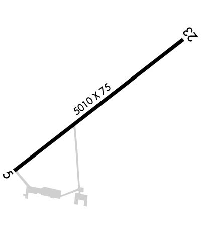
| Lat: N 3310.7 Long: W 09152.8 Elev: 184 Var: -02 Longest Runway: 5010 | ||
| CTAF: 122.8 | ||
| |||||||||||||||||||||||
| |||||||||||||||||||||||
| Rwy | Rwy | |||||||
| 5010x75 | 5010' | 5010x75 | 5010' | |||||
| Runway ID | Single Wheel | Double Wheel | Double Tandem Wheel | Dual Double Wheel |
| 05/23 | 19,000 | N/A | N/A | N/A |
| These numbers are Advisory and are not limits. The Airport Manager should have more accurate Weight Limits | ||||
 Airport Diagram might not be current. | |
| Facility Name: | Z M JACK STELL FLD |
| City Name: | CROSSETT |
| County: | ASHLEY |
| State abbrev: | AR |
| State Name: | ARKANSAS |
| Ownership: | PUBLICLY OWNED |
| Use: | OPEN TO THE PUBLIC |
| Owner's Name: | CITY OF CROSSETT |
| Address: | 201 MAIN |
| CROSSETT, AR 71635 | |
| Owner's Phone: | 870-364-4131 |
| Manager's Name: | TODD FREEMAN |
| Address: | PO BOX 637 |
| CROSSETT, AR 71635 | |
| Phone: | 870-304-3313 |
| FAA Region: | SOUTHWEST |
| FAA Field Office: | AOK |
| Date | Sunrise | Sunset |
|---|---|---|
| 09/24/21 Friday | 6:57 | 19:02 |
| 09/25/21 Saturday | 6:57 | 19:00 |
| 09/26/21 Sunday | 6:58 | 18:59 |
| 09/27/21 Monday | 6:59 | 18:58 |
| 09/28/21 Tuesday | 7:00 | 18:56 |
| 09/29/21 Wednesday | 7:00 | 18:55 |
| 09/30/21 Thursday | 7:01 | 18:54 |
| 10/01/21 Friday | 7:02 | 18:52 |
| 10/02/21 Saturday | 7:02 | 18:51 |
| 10/03/21 Sunday | 7:03 | 18:50 |
| 10/04/21 Monday | 7:04 | 18:48 |
| 10/05/21 Tuesday | 7:04 | 18:47 |
| 10/06/21 Wednesday | 7:05 | 18:46 |
| 10/07/21 Thursday | 7:06 | 18:44 |
| Airport Attendance Schedule | MON-FRI IREG |
| Airport Status | OPERATIONAL (This Status can change at any time - please check NOTAMS) |
| Airport Lighting Schedule | SS-SR |
| Airport Storage Available | Tie Downs, Hanger |
| Extra Services Available | Crop Dusting |
| Wind Indicator | YES - (lighted) |
| Control Tower | NO |
| CTAF Frequency | 122.800 |
| Unicom Frequency | 122.800 |
| Rotating Beacon Color | CLEAR-GREEN (Light Land Airport) |
| Segmented Circle | YES |
| Landing Fee | YES; FEE CHRGD ACFT GTR THAN 8645 LBS UNLESS FUEL PURCHASED. |
| Airport Inspected | STATE - performed by STATE AERONAUTICAL PERSONNEL |
| Inspection Date | 02/21/2020 |
| Type of Fuel Available | Grade 100LL, JET A (freeze point -40C); -10SELF SERVE FUEL AVBL 24 HRS WITH CREDIT CARD. |
| Airframe Repair Service | None |
| Power Plant Repair Service | None |
| Latitude | N3310.7 |
| Longitude | W09152.8 (ESTIMATED) |
| Arpt Elevation | 183ft (SURVEYED) |
| Magnetic Variation | 02E |
| 5 miles NE | of CROSSETT |
| Traffic Pattern Altitude | |
| Sectional Chart | MEMPHIS |
| Operations (Reported) | Yearly | Avg. Daily |
|---|---|---|
| General Aviation Transient | 4500 | 12 |
| General Aviation Local | 12000 | 33 |
| Air Taxi | 20 | 0 |
| Commerical | 0 | 0 |
| Commuter | 0 | 0 |
| Military | 75 | 0 |
| Aircraft based on Field | |
|---|---|
| General Aviation Singles | 15 |
| General Aviation Multi | 1 |
| Jet Aircraft | 0 |
| General Aviation Helicopters | 0 |
| Military Aircraft | 0 |
| Gliders | 0 |
| Ultralights | 0 |
| FSS on field | NO |
| FSS tie-in | JONESBORO |
| FSS Phone | 1-800-WX-BRIEF |
| Who issues Notams | JBR |
| Notam D service at airport | YES |
| ARTCC Name | MEMPHIS |
| Airport Certification | |
| Aircraft Rescue & Firefighting Index | None |
| Airport of Entry | No |
| Custom Landing Rights | No |
| Joint Civil/Military | No |
| Military Landing rights | YES |
| NATIONAL PLAN OF INTEGRATED AIRPORT SYSTEMS (NPIAS) |
| GRANT AGREEMENT HAS EXPIRED; HOWEVER, AGREEMENT REMAINS IN EFFECT FOR THIS FACILITY AS LONG AS IT IS PUBLIC USE. |
| MIDFIELD TWY CLSD TO ACFT OVER 6000 LBS. |
| FOR CD CTC MEMPHIS ARTCC AT 901-368-8453/8449. |
Airport Communications & Frequencies:
| |||||||||
| Runway: 05 | Runway: 23 | ||
| Mag heading: | 50° | Mag heading: | 230° |
| Rwy Slope: | .11% Up | Rwy Slope: | -.11% Down |
| Approach: | Approach: | ||
| Pattern: | Left Traffic | Pattern: | Left Traffic |
| Markings: | NONPRECISION INSTRUMENT | Markings: | NONPRECISION INSTRUMENT |
| Marking Condition: | GOOD | Marking Condition: | GOOD |
| Arresting Dev: | Arresting Dev: | ||
| Lat & Long: | N3310.4 W09153.2 | Lat. & Long.: | N3311.0 W09152.4 |
| Elev: | 177.7 ft. MSL | Elev: | 183.1 ft. MSL |
| TCH: | 42 ft. AGL | TCH: | 42 ft. AGL |
| Visual Glide Path: | 3.25 degrees | Visual Glide Path: | 3.25 degrees |
| Displaced Threshold: | No | Displaced Threshold: | No |
| Touchdown Zone: | YES | Touchdown Zone: | YES |
| Touchdown Elev.: | 183.4 feet | Touchdown Elev.: | 183.5 feet |
| Visual Glide Slope: | 2-Light PAPI on LEFT side of Runway; PAPI NIGHTTIME ONLY | Visual Glide Slope: | 2-Light PAPI on LEFT side of Runway; PAPI NIGHTTIME ONLY |
| RVR Equipment: | RVR Equipment: | ||
| RVV Equipment: | NO | RVV Equipment: | NO |
| Approach Lights: | Approach Lights: | ||
| REIL: | NO | REIL: | NO |
| Centerline Lights: | NO | Centerline Lights: | NO |
| Touchdown lights: | NO | Touchdown lights: | NO |
| Runway Category: | Runway with a Visual Approach | Runway Category: | Runway with a Non-precision Approach having visibility minimums greater than 3/4 mile |
| Declared Distances: | Declared Distances: | ||
| Obstructions: | TREES | Obstructions: | |
| Marked: | NOT Marked/Lighted | Marked: | |
| Clearance slope: | 8:1 | Clearance slope: | 50:1 |
| Obstruction height: | 45 feet AGL | Obstruction height: | |
| Dist. from runway: | 600 feet | Dist. from runway: | |
| Centerline offset: | 300 left of centerline | Centerline offset: | |
| Comments: | Comments: |
Thanks for using FltPlan.com
all rights reserved © 1999-2021 by Flight Plan LLC

