
| C DAVID CAMPBELL FIELD CORSICANA TX |
| |
| Lat: N 3201.7 Long: W 09624.0 Elev: 449 Var: -06 Longest Runway: 5004 | ||
| AWOS: 120.67 CTAF: 122.8 | ||
| ||||||
| ||||||
|
| Rwy | Rwy | |||||||
| 3200x75 | 3200' | 3200x75 | 3200' | |||||
| 5004x75 | 5004' | 5004x75 | 5004' | |||||
| Runway ID | Single Wheel | Double Wheel | Double Tandem Wheel | Dual Double Wheel |
| 02/20 | N/A | N/A | N/A | N/A |
| 14/32 | 26,000 | N/A | N/A | N/A |
| These numbers are Advisory and are not limits. The Airport Manager should have more accurate Weight Limits | ||||
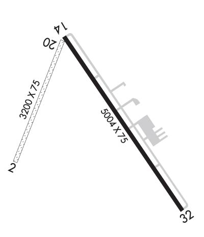 Airport Diagram might not be current. | |
| Facility Name: | C DAVID CAMPBELL FLD-CORSICANA MUNI |
| City Name: | CORSICANA |
| County: | NAVARRO |
| State abbrev: | TX |
| State Name: | TEXAS |
| Ownership: | PUBLICLY OWNED |
| Use: | OPEN TO THE PUBLIC |
| Owner's Name: | CITY OF CORSICANA |
| Address: | 200 N. 12TH |
| CORSICANA, TX 75110 | |
| Owner's Phone: | 903-654-4884 |
| Manager's Name: | TERRY FRANKS |
| Address: | 200 N. 12TH |
| CORSICANA, TX 75110 | |
| Phone: | (903) 654-4884; ALSO 903-654-4878. EMERGENCY PH 903-654-4902 (CITY POLICE). |
| FAA Region: | SOUTHWEST |
| FAA Field Office: | TEX |

| Date | Sunrise | Sunset |
|---|---|---|
| 09/24/21 Friday | 7:15 | 19:20 |
| 09/25/21 Saturday | 7:16 | 19:19 |
| 09/26/21 Sunday | 7:16 | 19:17 |
| 09/27/21 Monday | 7:17 | 19:16 |
| 09/28/21 Tuesday | 7:17 | 19:15 |
| 09/29/21 Wednesday | 7:18 | 19:13 |
| 09/30/21 Thursday | 7:19 | 19:12 |
| 10/01/21 Friday | 7:19 | 19:11 |
| 10/02/21 Saturday | 7:20 | 19:09 |
| 10/03/21 Sunday | 7:21 | 19:08 |
| 10/04/21 Monday | 7:21 | 19:07 |
| 10/05/21 Tuesday | 7:22 | 19:06 |
| 10/06/21 Wednesday | 7:23 | 19:04 |
| 10/07/21 Thursday | 7:23 | 19:03 |
| Airport Attendance Schedule | MON-SAT 0800-1700 |
| Airport Status | OPERATIONAL (This Status can change at any time - please check NOTAMS) |
| Airport Lighting Schedule | MIRL RWY 14/32 PRESET MED INTST; TO INCR INTST & ACTVT PAPI RWY 32 - CTAF. VASI RWY 14 OPRS CONSLY. |
| Airport Storage Available | Tie Downs, Hanger |
| Extra Services Available | Flight Instruction |
| Wind Indicator | YES - (lighted) |
| Control Tower | NO |
| CTAF Frequency | 122.800 |
| Unicom Frequency | 122.800 |
| Rotating Beacon Color | CLEAR-GREEN (Light Land Airport) |
| Segmented Circle | YES |
| Landing Fee | NO |
| Airport Inspected | STATE - performed by PRIVATE CONTRACT PERSONNEL |
| Inspection Date | 05/17/2020 |
| Type of Fuel Available | Grade 100LL, JET A (freeze point -40C)MOGAS; -10FUEL AVBL SELF-SERVE.; -MO91 OCTANE. |
| Airframe Repair Service | MAJOR |
| Power Plant Repair Service | MAJOR |
| Latitude | N3201.7 |
| Longitude | W09624.0 (ESTIMATED) |
| Arpt Elevation | 448ft (SURVEYED) |
| Magnetic Variation | 06E |
| 5 miles SE | of CORSICANA |
| Traffic Pattern Altitude | |
| Sectional Chart | DALLAS-FT WORTH |
| Operations (Reported) | Yearly | Avg. Daily |
|---|---|---|
| General Aviation Transient | 6300 | 17 |
| General Aviation Local | 18900 | 52 |
| Air Taxi | 0 | 0 |
| Commerical | 0 | 0 |
| Commuter | 0 | 0 |
| Military | 0 | 0 |
| Aircraft based on Field | |
|---|---|
| General Aviation Singles | 45 |
| General Aviation Multi | 7 |
| Jet Aircraft | 0 |
| General Aviation Helicopters | 1 |
| Military Aircraft | 0 |
| Gliders | 0 |
| Ultralights | 0 |
| FSS on field | NO |
| FSS tie-in | FORT WORTH |
| FSS Phone | 1-800-WX-BRIEF |
| Who issues Notams | CRS |
| Notam D service at airport | YES |
| ARTCC Name | FORT WORTH |
| Airport Certification | |
| Aircraft Rescue & Firefighting Index | None |
| Airport of Entry | No |
| Custom Landing Rights | No |
| Joint Civil/Military | No |
| Military Landing rights | YES |
| NATIONAL PLAN OF INTEGRATED AIRPORT SYSTEMS (NPIAS) |
| GRANT AGREEMENTS UNDER FAAP/ADAP/AIP |
| SURPLUS PROPERTY AGREEMENT UNDER REGULATION 16-WAA |
| ASSURANCES PURSUANT TO TITLE VI, CIVIL RIGHTS ACT OF 1964 |
| THIS AIRPORT HAS BEEN SURVEYED BY THE NATIONAL GEODETIC SURVEY. |
| RWY 02, 45 FT MKD PWRLINE AT 935 FT ACRS EXTDD CNTRLN. |
| DEER ON & INVOF ARPT. |
| FOR CD CTC FORT WORTH ARTCC AT 817-858-7584. |
Airport Communications & Frequencies:
| |||||||||
| Runway: 02 | Runway: 20 | ||
| Mag heading: | 16° | Mag heading: | 196° |
| Rwy Slope: | .31% Up | Rwy Slope: | -.31% Down |
| Approach: | Approach: | ||
| Pattern: | Left Traffic | Pattern: | Left Traffic |
| Markings: | Markings: | ||
| Marking Condition: | Marking Condition: | ||
| Arresting Dev: | Arresting Dev: | ||
| Lat & Long: | N3201.5 W09624.4 | Lat. & Long.: | N3202.0 W09624.2 |
| Elev: | 438.0 ft. MSL | Elev: | 448.0 ft. MSL |
| TCH: | TCH: | ||
| Visual Glide Path: | Visual Glide Path: | ||
| Displaced Threshold: | No | Displaced Threshold: | No |
| Touchdown Zone: | NO | Touchdown Zone: | NO |
| Touchdown Elev.: | Touchdown Elev.: | ||
| Visual Glide Slope: | Visual Glide Slope: | ||
| RVR Equipment: | RVR Equipment: | ||
| RVV Equipment: | NO | RVV Equipment: | NO |
| Approach Lights: | Approach Lights: | ||
| REIL: | NO | REIL: | NO |
| Centerline Lights: | NO | Centerline Lights: | NO |
| Touchdown lights: | NO | Touchdown lights: | NO |
| Runway Category: | Runway with a Visual Approach | Runway Category: | Runway with a Visual Approach |
| Declared Distances: | Declared Distances: | ||
| Obstructions: | TREE; 40 FT MKD PWRLINE, 918 FT DSTC, 205 FT L, OBSTN CLNC SLOPE 16:1. | Obstructions: | TREES |
| Marked: | MARKED | Marked: | NOT Marked/Lighted |
| Clearance slope: | 16:1 | Clearance slope: | 26:1 |
| Obstruction height: | 25 feet AGL | Obstruction height: | 25 feet AGL |
| Dist. from runway: | 420 feet | Dist. from runway: | 668 feet |
| Centerline offset: | 125 right of centerline | Centerline offset: | 130 feet left of centerline |
| Comments: | Comments: |
| Runway: 14 | Runway: 32 | ||
| Mag heading: | 139° | Mag heading: | 319° |
| Rwy Slope: | -.33% Down | Rwy Slope: | .33% Up |
| Approach: | Approach: | ||
| Pattern: | Left Traffic | Pattern: | Left Traffic |
| Markings: | NONPRECISION INSTRUMENT | Markings: | NONPRECISION INSTRUMENT |
| Marking Condition: | GOOD | Marking Condition: | GOOD |
| Arresting Dev: | Arresting Dev: | ||
| Lat & Long: | N3202.0 W09624.2 | Lat. & Long.: | N3201.3 W09623.6 |
| Elev: | 448.6 ft. MSL | Elev: | 431.9 ft. MSL |
| TCH: | 26 ft. AGL | TCH: | 40 ft. AGL |
| Visual Glide Path: | 3.00 degrees | Visual Glide Path: | 3.00 degrees |
| Displaced Threshold: | No | Displaced Threshold: | No |
| Touchdown Zone: | YES | Touchdown Zone: | YES |
| Touchdown Elev.: | 448.6 feet | Touchdown Elev.: | 441.8 feet |
| Visual Glide Slope: | 4-BOX VASI ON RIGHT SIDE OF RUNWAY | Visual Glide Slope: | 2-Light PAPI on LEFT side of Runway |
| RVR Equipment: | RVR Equipment: | ||
| RVV Equipment: | NO | RVV Equipment: | NO |
| Approach Lights: | Approach Lights: | ||
| REIL: | YES | REIL: | YES |
| Centerline Lights: | NO | Centerline Lights: | NO |
| Touchdown lights: | NO | Touchdown lights: | NO |
| Runway Category: | Runway with a Non-precision Approach having visibility minimums greater than 3/4 mile | Runway Category: | Runway with a Non-precision Approach having visibility minimums greater than 3/4 mile |
| Declared Distances: | Declared Distances: | ||
| Obstructions: | ROAD | Obstructions: | TREES |
| Marked: | NOT Marked/Lighted | Marked: | NOT Marked/Lighted |
| Clearance slope: | 14:1 | Clearance slope: | 4:1 |
| Obstruction height: | 16 feet AGL | Obstruction height: | 26 feet AGL |
| Dist. from runway: | 430 feet | Dist. from runway: | 322 feet |
| Centerline offset: | 280 right of centerline | Centerline offset: | 280 feet right of centerline |
| Comments: | Comments: |
Thanks for using FltPlan.com
all rights reserved © 1999-2021 by Flight Plan LLC