| ST LOUIS DOWNTOWN CAHOKIA/ST LOUIS IL |
| |
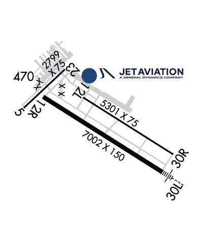
| Lat: N 3834.2 Long: W 09009.3 Elev: 413 Var: -00 Longest Runway: 7002 | ||
| Clr Del: 118.27/121.8 Dept. ATIS: 121.45 Arr. ATIS: 121.45 Ground: 121.8 Tower: 119.92 | ||
| |||||||||||||||||||||||||||||||||||||||||||||||||||||||||||||||||||||
| |||||||||||||||||||||||||||||||||||||||||||||||||||||||||||||||||||||
| |||||||||||||||||||||||||||||||||||||||||||||||||||||||||||||||||||||
| Rwy | Rwy | |||||||
| 2799x75 | 2799' | 2799x75 | 2799' | |||||
| 5301x75 | 5301' | 5301x75 | 5301' | |||||
| 7002x150 | 7002' | 7002x150 | 7002' | 109.10 - 302° | ||||
| Runway ID | Single Wheel | Double Wheel | Double Tandem Wheel | Dual Double Wheel |
| 05/23 | 12,000 | N/A | N/A | N/A |
| 12L/30R | 30,000 | 30,000 | N/A | N/A |
| 12R/30L | 96,000 | 125,000 | 182,000 | N/A |
| These numbers are Advisory and are not limits. The Airport Manager should have more accurate Weight Limits | ||||
 Airport Diagram might not be current. | |
| Facility Name: | ST LOUIS DOWNTOWN |
| City Name: | CAHOKIA/ST LOUIS |
| County: | ST CLAIR |
| State abbrev: | IL |
| State Name: | ILLINOIS |
| Ownership: | PUBLICLY OWNED |
| Use: | OPEN TO THE PUBLIC |
| Owner's Name: | BI-STATE DEVELOPMENT AGENCY |
| Address: | 6100 ARCHVIEW DRIVE |
| CAHOKIA, IL 62206-1445 | |
| Owner's Phone: | 618-337-6060 |
| Manager's Name: | SANDRA SHORE |
| Address: | 6100 ARCHVIEW DRIVE |
| CAHOKIA, IL 62206-1445 | |
| Phone: | 618-337-6060 |
| FAA Region: | GREAT LAKES |
| FAA Field Office: | CHI |
| Date | Sunrise | Sunset |
|---|---|---|
| 06/08/26 Monday | 5:36 | 20:23 |
| 06/09/26 Tuesday | 5:36 | 20:24 |
| 06/10/26 Wednesday | 5:36 | 20:24 |
| 06/11/26 Thursday | 5:36 | 20:25 |
| 06/12/26 Friday | 5:36 | 20:25 |
| 06/13/26 Saturday | 5:36 | 20:26 |
| 06/14/26 Sunday | 5:36 | 20:26 |
| 06/15/26 Monday | 5:36 | 20:27 |
| 06/16/26 Tuesday | 5:36 | 20:27 |
| 06/17/26 Wednesday | 5:36 | 20:27 |
| 06/18/26 Thursday | 5:36 | 20:28 |
| 06/19/26 Friday | 5:36 | 20:28 |
| 06/20/26 Saturday | 5:36 | 20:28 |
| 06/21/26 Sunday | 5:36 | 20:28 |
| Airport Attendance Schedule | CONTINUOUS |
| Airport Status | OPERATIONAL (This Status can change at any time - please check NOTAMS) |
| Airport Lighting Schedule | ACTVT MALSR RWY 30L WHEN ATCT CLSD; REIL RWY 30R - CTAF. HIRL RWY 12R/30L PRESET MED INTST WHEN ATCT CLSD. MIRL RWY 12L & 30R NOT AVBL WHEN ATCT CLSD. PAPI RWY 12R & 30L OPR CONSLY. |
| Airport Storage Available | Tie Downs, Hanger |
| Extra Services Available | Charter, Flight Instruction, Aircraft Rental, Aircraft Sales |
| Wind Indicator | YES - (lighted) |
| Control Tower | YES |
| CTAF Frequency | 119.925 |
| Unicom Frequency | 122.950 |
| Rotating Beacon Color | WG |
| Segmented Circle | YES |
| Landing Fee | NO |
| Airport Inspected | STATE - performed by FAA AIRPORTS FIELD PERSONNEL |
| Inspection Date | 03/15/2023 |
| Type of Fuel Available | Grade 100LL, JET A (freeze point -40C) |
| Airframe Repair Service | MAJOR |
| Power Plant Repair Service | MAJOR |
| Latitude | N3834.2 |
| Longitude | W09009.3 (ESTIMATED) |
| Arpt Elevation | 412ft (SURVEYED) |
| Magnetic Variation | 00E |
| 1 miles E | of CAHOKIA/ST LOUIS |
| Traffic Pattern Altitude | |
| Sectional Chart | ST LOUIS |
| Operations (Reported) | Yearly | Avg. Daily |
|---|---|---|
| General Aviation Transient | 0 | 0 |
| General Aviation Local | 0 | 0 |
| Air Taxi | 0 | 0 |
| Commerical | 0 | 0 |
| Commuter | 0 | 0 |
| Military | 0 | 0 |
| Aircraft based on Field | |
|---|---|
| General Aviation Singles | 0 |
| General Aviation Multi | 0 |
| Jet Aircraft | 0 |
| General Aviation Helicopters | 0 |
| Military Aircraft | 0 |
| Gliders | 0 |
| Ultralights | 0 |
| FSS on field | NO |
| FSS tie-in | SAINT LOUIS |
| FSS Phone | 1-800-WX-BRIEF |
| Who issues Notams | CPS |
| Notam D service at airport | YES |
| ARTCC Name | KANSAS CITY |
| Airport Certification | CLSD TO SKED ACR OPS GTR THAN 9 PSGR SEATS. UNSKED ACR OPS GTR THAN 30 PSGR SEATS RQR 12 HR PPR. |
| Aircraft Rescue & Firefighting Index | AIRPORT HAS A CERTIFICATE UNDER CFR PART 139 |
| Airport of Entry | No |
| Custom Landing Rights | No |
| Joint Civil/Military | No |
| Military Landing rights | YES |
| NATIONAL PLAN OF INTEGRATED AIRPORT SYSTEMS (NPIAS) |
| GRANT AGREEMENTS UNDER FAAP/ADAP/AIP |
| ASSURANCES PURSUANT TO TITLE VI, CIVIL RIGHTS ACT OF 1964 |
| WATERFOWL ON & INVOF ARPT. |
| BE ALERT FOR STUDENT TRNG & HEL OPS. |
| ALL TWYS EXCP TWY B4 PPR ACFT OVER 120000 LBS. |
| SFC CONDS NOT MNTD 2100-0700 LCL. |
| RWY 05/2 3 RWY 05/23 NOT AVBL FOR PART 121/PART 380 OPS WITH SKED PAX CARRYING OPS MORE THAN 9 PAX SEATS AND NON-SKED PAX CARRYING OPS MORE THAN 30 PAX SEATS. NO PART 121/PART 380 OPS EXC FOR TAX. |
| RWY 12L/ 30RRWY 12L/30R NOT AVBL FOR PART 121/PART 380 OPS WITH SKED PAX CARRYING OPS MORE THAN 9 PAX SEATS AND NON-SKED PAX CARRYING OPS MORE THAN 30 PAX SEATS. NO PART 121/PART 380 OPS EXC FOR TAX. |
| RWY 12R/ 30LW.B.C. GROSS WT (2S) 160. |
| RWY 12R/ 30L200 WITH PPR. |
| RWY 12R/ 30LPCR VALUE: 400/F/D/X/T |
Airport Communications & Frequencies:
| ||||||||||||||||||||||||||
| Runway: 05 | Runway: 23 | ||
| Mag heading: | 47° | Mag heading: | 227° |
| Rwy Slope: | -.05% Down | Rwy Slope: | .05% Up |
| Approach: | Approach: | ||
| Pattern: | Left Traffic | Pattern: | Left Traffic |
| Markings: | BASIC | Markings: | BASIC |
| Marking Condition: | POOR; SFC MARKINGS FADED. | Marking Condition: | POOR; SFC MARKINGS FADED. |
| Arresting Dev: | Arresting Dev: | ||
| Lat & Long: | N3834.3 W09010.1 | Lat. & Long.: | N3834.7 W09009.7 |
| Elev: | 410.0 ft. MSL | Elev: | 408.6 ft. MSL |
| TCH: | TCH: | ||
| Visual Glide Path: | Visual Glide Path: | ||
| Displaced Threshold: | No | Displaced Threshold: | No |
| Touchdown Zone: | YES | Touchdown Zone: | YES |
| Touchdown Elev.: | 412.9 feet | Touchdown Elev.: | 412.9 feet |
| Visual Glide Slope: | Visual Glide Slope: | ||
| RVR Equipment: | RVR Equipment: | ||
| RVV Equipment: | NO | RVV Equipment: | NO |
| Approach Lights: | Approach Lights: | ||
| REIL: | NO | REIL: | NO |
| Centerline Lights: | NO | Centerline Lights: | NO |
| Touchdown lights: | NO | Touchdown lights: | NO |
| Runway Category: | Runway with a Visual Approach | Runway Category: | Runway with a Visual Approach |
| Declared Distances: | TORA:2799' TODA:2799' ASDA:2799' LDA:2799' | Declared Distances: | TORA:2799' TODA:2799' ASDA:2799' LDA:2799' |
| Obstructions: | TREE | Obstructions: | TOWER |
| Marked: | NOT Marked/Lighted | Marked: | LIGHTED |
| Clearance slope: | 11:1 | Clearance slope: | 20:1 |
| Obstruction height: | 54 feet AGL | Obstruction height: | 72 feet AGL |
| Dist. from runway: | 811 feet | Dist. from runway: | 1647 feet |
| Centerline offset: | 58 right of centerline | Centerline offset: | 16 feet right of centerline |
| Comments: | Comments: |
| Runway: 12L | Runway: 30R | ||
| Mag heading: | 122° | Mag heading: | 302° |
| Rwy Slope: | -.07% Down | Rwy Slope: | .07% Up |
| Approach: | Approach: | ||
| Pattern: | Left Traffic | Pattern: | Right Traffic |
| Markings: | NONPRECISION INSTRUMENT | Markings: | NONPRECISION INSTRUMENT |
| Marking Condition: | FAIR | Marking Condition: | FAIR |
| Arresting Dev: | Arresting Dev: | ||
| Lat & Long: | N3834.4 W09009.5 | Lat. & Long.: | N3834.0 W09008.6 |
| Elev: | 410.0 ft. MSL | Elev: | 406.5 ft. MSL |
| TCH: | TCH: | ||
| Visual Glide Path: | Visual Glide Path: | ||
| Displaced Threshold: | No | Displaced Threshold: | No |
| Touchdown Zone: | YES | Touchdown Zone: | YES |
| Touchdown Elev.: | 410.0 feet | Touchdown Elev.: | 407.9 feet |
| Visual Glide Slope: | Visual Glide Slope: | ||
| RVR Equipment: | RVR Equipment: | ||
| RVV Equipment: | NO | RVV Equipment: | NO |
| Approach Lights: | Approach Lights: | ||
| REIL: | YES | REIL: | YES |
| Centerline Lights: | NO | Centerline Lights: | NO |
| Touchdown lights: | NO | Touchdown lights: | NO |
| Runway Category: | Runway with a Visual Approach | Runway Category: | Runway with a Non-precision Approach having visibility minimums greater than 3/4 mile |
| Declared Distances: | TORA:5300' TODA:5300' ASDA:5300' LDA:5300' | Declared Distances: | TORA:5300' TODA:5300' ASDA:5300' LDA:5300' |
| Obstructions: | TREE | Obstructions: | TREE |
| Marked: | NOT Marked/Lighted | Marked: | NOT Marked/Lighted |
| Clearance slope: | 37:1 | Clearance slope: | 34:1 |
| Obstruction height: | 96 feet AGL | Obstruction height: | 72 feet AGL |
| Dist. from runway: | 3817 feet | Dist. from runway: | 2664 feet |
| Centerline offset: | 254 left of centerline | Centerline offset: | 306 feet right of centerline |
| Comments: | Comments: |
| Runway: 12R | Runway: 30L | ||
| Mag heading: | 122° | Mag heading: | 302° |
| Rwy Slope: | -.06% Down | Rwy Slope: | .06% Up |
| Approach: | Approach: | ILS | |
| Pattern: | Right Traffic | Pattern: | Left Traffic |
| Markings: | PRECISION INSTRUMENT | Markings: | PRECISION INSTRUMENT |
| Marking Condition: | GOOD | Marking Condition: | GOOD |
| Arresting Dev: | Arresting Dev: | ||
| Lat & Long: | N3834.4 W09009.9 | Lat. & Long.: | N3833.8 W09008.7 |
| Elev: | 412.4 ft. MSL | Elev: | 408.0 ft. MSL |
| TCH: | 49 ft. AGL | TCH: | 53 ft. AGL |
| Visual Glide Path: | 3.00 degrees | Visual Glide Path: | 3.00 degrees |
| Displaced Threshold: | No | Displaced Threshold: | No |
| Touchdown Zone: | YES | Touchdown Zone: | YES |
| Touchdown Elev.: | 412.4 feet | Touchdown Elev.: | 411.2 feet |
| Visual Glide Slope: | 4-Light PAPI on LEFT side of Runway | Visual Glide Slope: | 4-Light PAPI on LEFT side of Runway |
| RVR Equipment: | RVR Equipment: | ||
| RVV Equipment: | NO | RVV Equipment: | NO |
| Approach Lights: | Approach Lights: | MALSR - 1,400 foot medium intensity approach lighting system with runway alignment indicator lights | |
| REIL: | YES | REIL: | NO |
| Centerline Lights: | NO | Centerline Lights: | NO |
| Touchdown lights: | NO | Touchdown lights: | NO |
| Runway Category: | Runway with a Non-precision Approach having visibility minimums greater than 3/4 mile | Runway Category: | Precision Instrument Runway |
| Declared Distances: | TORA:7002' TODA:7002' ASDA:7002' LDA:7002' | Declared Distances: | TORA:7002' TODA:7002' ASDA:7002' LDA:7002' |
| Obstructions: | TREE | Obstructions: | POLE |
| Marked: | NOT Marked/Lighted | Marked: | NOT Marked/Lighted |
| Clearance slope: | 20:1 | Clearance slope: | 36:1 |
| Obstruction height: | 30 feet AGL | Obstruction height: | 29 feet AGL |
| Dist. from runway: | 809 feet | Dist. from runway: | 1688 feet |
| Centerline offset: | 487 left of centerline | Centerline offset: | 362 feet left of centerline |
| Comments: | Comments: |
Thanks for using FltPlan.com
all rights reserved © 1999-2026 by Flight Plan LLC