| CHESAPEAKE RGNL NORFOLK VA |
| |
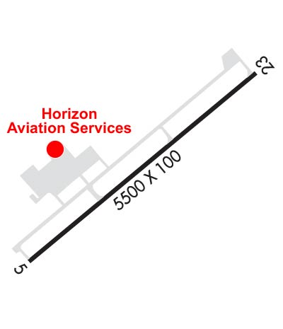
| Lat: N 3639.9 Long: W 07619.2 Elev: 19 Var: +11 Longest Runway: 5500 | ||
| Clr Del: 135.07 GCO AWOS: 123.67 CTAF: 123.07 | ||
| ||||||||||||||||||||||||||||||||||||||||||||||||||||||||||||||||||||
| ||||||||||||||||||||||||||||||||||||||||||||||||||||||||||||||||||||
| ||||||||||||||||||||||||||||||||||||||||||||||||||||||||||||||||||||
| Rwy | Rwy | |||||||
| 5500x100 | 5500' | 111.70 - 047° | 5500x100 | 5500' | ||||
| Runway ID | Single Wheel | Double Wheel | Double Tandem Wheel | Dual Double Wheel |
| 05/23 | 30,000 | N/A | N/A | N/A |
| These numbers are Advisory and are not limits. The Airport Manager should have more accurate Weight Limits | ||||
 Airport Diagram might not be current. | |
| Facility Name: | CHESAPEAKE RGNL |
| City Name: | NORFOLK |
| County: | CHESAPEAKE |
| State abbrev: | VA |
| State Name: | VIRGINIA |
| Ownership: | PUBLICLY OWNED |
| Use: | OPEN TO THE PUBLIC |
| Owner's Name: | CHESAPEAKE AIRPORT AUTHORITY |
| Address: | 2800 AIRPORT DRIVE |
| CHESAPEAKE, VA 23323-6402 | |
| Owner's Phone: | 757-432-8110 |
| Manager's Name: | CHRIS SCHRANTZ |
| Address: | 2800 AIRPORT DRIVE |
| CHESAPEAKE, VA 23323-6402 | |
| Phone: | 757-432-8110 |
| FAA Region: | EASTERN |
| FAA Field Office: | DCA |

| Date | Sunrise | Sunset |
|---|---|---|
| 09/24/21 Friday | 6:55 | 19:00 |
| 09/25/21 Saturday | 6:55 | 18:58 |
| 09/26/21 Sunday | 6:56 | 18:57 |
| 09/27/21 Monday | 6:57 | 18:55 |
| 09/28/21 Tuesday | 6:58 | 18:54 |
| 09/29/21 Wednesday | 6:59 | 18:52 |
| 09/30/21 Thursday | 6:59 | 18:51 |
| 10/01/21 Friday | 7:00 | 18:49 |
| 10/02/21 Saturday | 7:01 | 18:48 |
| 10/03/21 Sunday | 7:02 | 18:46 |
| 10/04/21 Monday | 7:03 | 18:45 |
| 10/05/21 Tuesday | 7:04 | 18:43 |
| 10/06/21 Wednesday | 7:05 | 18:42 |
| 10/07/21 Thursday | 7:05 | 18:40 |
| Airport Attendance Schedule | 7 Days A Week 0800-2000 |
| Airport Status | OPERATIONAL (This Status can change at any time - please check NOTAMS) |
| Airport Lighting Schedule | ACTVT HIRL RY 05/23, MALSR RY 05 AND REIL RY 23 - CTAF. |
| Airport Storage Available | Tie Downs, Hanger |
| Extra Services Available | Avionics, Charter, Flight Instruction, Aircraft Rental, Aircraft Sales |
| Wind Indicator | YES - (lighted) |
| Control Tower | NO |
| CTAF Frequency | 123.075 |
| Unicom Frequency | 123.075 |
| Rotating Beacon Color | CLEAR-GREEN (Light Land Airport) |
| Segmented Circle | YES |
| Landing Fee | NO |
| Airport Inspected | STATE - performed by STATE AERONAUTICAL PERSONNEL |
| Inspection Date | 10/15/2020 |
| Type of Fuel Available | Grade 100LL, JET A (freeze point -40C); -A FOR FUEL AFT HRS CALL IN ADVANCE 757-421-9000. SELF-SVC AVBL.; -10FOR FUEL AFTER HRS CALL 757-421-9000. |
| Airframe Repair Service | MAJOR |
| Power Plant Repair Service | MAJOR |
| Latitude | N3639.9 |
| Longitude | W07619.2 (ESTIMATED) |
| Arpt Elevation | 18ft (SURVEYED) |
| Magnetic Variation | 11W |
| 12 miles S | of NORFOLK |
| Traffic Pattern Altitude | TPA 1000FT AGL (1020 FT MSL) TURBINE/LARGE ACFT 1500 FT AGL (1520 FT MSL). |
| Sectional Chart | WASHINGTON |
| Operations (Reported) | Yearly | Avg. Daily |
|---|---|---|
| General Aviation Transient | 13519 | 37 |
| General Aviation Local | 33571 | 92 |
| Air Taxi | 2023 | 6 |
| Commerical | 0 | 0 |
| Commuter | 0 | 0 |
| Military | 1185 | 3 |
| Aircraft based on Field | |
|---|---|
| General Aviation Singles | 102 |
| General Aviation Multi | 6 |
| Jet Aircraft | 0 |
| General Aviation Helicopters | 2 |
| Military Aircraft | 0 |
| Gliders | 0 |
| Ultralights | 0 |
| FSS on field | NO |
| FSS tie-in | LEESBURG |
| FSS Phone | 1-800-WX-BRIEF |
| Who issues Notams | CPK |
| Notam D service at airport | YES |
| ARTCC Name | WASHINGTON |
| Airport Certification | |
| Aircraft Rescue & Firefighting Index | None |
| Airport of Entry | No |
| Custom Landing Rights | No |
| Joint Civil/Military | No |
| Military Landing rights | YES |
| NATIONAL PLAN OF INTEGRATED AIRPORT SYSTEMS (NPIAS) |
| GRANT AGREEMENTS UNDER FAAP/ADAP/AIP |
| ASSURANCES PURSUANT TO TITLE VI, CIVIL RIGHTS ACT OF 1964 |
| THIS AIRPORT HAS BEEN SURVEYED BY THE NATIONAL GEODETIC SURVEY. |
| DEER AND GEESE ON & INVOF RY. |
| GCO AVBL ON FREQ 135.075 THRU NORFOLK CD. IF UN, FOR CD CTC NORFOLK APCH AT 757-464-0757. |
| NOISE ABATEMENT PROCEDURES IN EFFECT; CTC AMGR 757-432-8110. |
Airport Communications & Frequencies:
| ||||||||||||||||||
| Runway: 05 | Runway: 23 | ||
| Mag heading: | 47° | Mag heading: | 227° |
| Rwy Slope: | .03% Up | Rwy Slope: | -.03% Down |
| Approach: | ILS/DME | Approach: | |
| Pattern: | Left Traffic | Pattern: | Right Traffic |
| Markings: | PRECISION INSTRUMENT | Markings: | NONPRECISION INSTRUMENT |
| Marking Condition: | FAIR | Marking Condition: | FAIR |
| Arresting Dev: | Arresting Dev: | ||
| Lat & Long: | N3639.6 W07619.6 | Lat. & Long.: | N3640.3 W07618.9 |
| Elev: | 16.5 ft. MSL | Elev: | 18.4 ft. MSL |
| TCH: | 43 ft. AGL | TCH: | 42 ft. AGL |
| Visual Glide Path: | 3.00 degrees | Visual Glide Path: | 3.00 degrees |
| Displaced Threshold: | No | Displaced Threshold: | No |
| Touchdown Zone: | YES | Touchdown Zone: | YES |
| Touchdown Elev.: | 18.3 feet | Touchdown Elev.: | 18.7 feet |
| Visual Glide Slope: | 4-Light PAPI on LEFT side of Runway | Visual Glide Slope: | 4-Light PAPI on LEFT side of Runway |
| RVR Equipment: | RVR Equipment: | ||
| RVV Equipment: | NO | RVV Equipment: | NO |
| Approach Lights: | MALSR - 1,400 foot medium intensity approach lighting system with runway alignment indicator lights | Approach Lights: | |
| REIL: | NO | REIL: | YES |
| Centerline Lights: | NO | Centerline Lights: | NO |
| Touchdown lights: | NO | Touchdown lights: | NO |
| Runway Category: | Precision Instrument Runway | Runway Category: | Runway with a Non-precision Approach having visibility minimums greater than 3/4 mile |
| Declared Distances: | Declared Distances: | ||
| Obstructions: | TREE | Obstructions: | TREE |
| Marked: | NOT Marked/Lighted | Marked: | NOT Marked/Lighted |
| Clearance slope: | 26:1 | Clearance slope: | 22:1 |
| Obstruction height: | 59 feet AGL | Obstruction height: | 89 feet AGL |
| Dist. from runway: | 1754 feet | Dist. from runway: | 2205 feet |
| Centerline offset: | 720 left of centerline | Centerline offset: | 166 feet right of centerline |
| Comments: | Comments: |
Thanks for using FltPlan.com
all rights reserved © 1999-2021 by Flight Plan LLC