
| COLUMBIA RGNL COLUMBIA MO |
| |
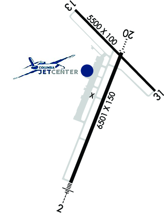
| Lat: N 3849.0 Long: W 09213.1 Elev: 889 Var: -00 Longest Runway: 6501 | ||
| Dept. ATIS: 128.45 Arr. ATIS: 128.45 AWOS: 128.45 Ground: 121.6 Tower: 119.3 | ||
| |||||||||||||||||||||||||||||||||||||||||||||||||||||||||||||
| |||||||||||||||||||||||||||||||||||||||||||||||||||||||||||||
| |||||||||||||||||||||||||||||||||||||||||||||||||||||||||||||
| Rwy | Rwy | |||||||
| 6501x150 | 6501' | 110.70 - 021° | 6501x150 | 6501' | ||||
| 5500x100 | 5500' | 5500x100 | 5500' | |||||
| Runway ID | Single Wheel | Double Wheel | Double Tandem Wheel | Dual Double Wheel |
| 02/20 | 71,000 | 86,000 | 144,000 | N/A |
| 13/31 | 67,000 | 81,000 | 135,000 | N/A |
| These numbers are Advisory and are not limits. The Airport Manager should have more accurate Weight Limits | ||||
 Airport Diagram might not be current. | |
| Facility Name: | COLUMBIA RGNL |
| City Name: | COLUMBIA |
| County: | BOONE |
| State abbrev: | MO |
| State Name: | MISSOURI |
| Ownership: | PUBLICLY OWNED |
| Use: | OPEN TO THE PUBLIC |
| Owner's Name: | CITY OF COLUMBIA |
| Address: | P O BOX 6015 |
| COLUMBIA, MO 65205 | |
| Owner's Phone: | (573) 874-2489 |
| Manager's Name: | MICHAEL PARKS; AIRPORT MANAGER |
| Address: | 11300 S. AIRPORT RD |
| COLUMBIA, MO 65201 | |
| Phone: | (573) 817-5064 |
| FAA Region: | CENTRAL |
| FAA Field Office: | NONE |
| Date | Sunrise | Sunset |
|---|---|---|
| 09/24/21 Friday | 6:58 | 19:03 |
| 09/25/21 Saturday | 6:59 | 19:01 |
| 09/26/21 Sunday | 7:00 | 19:00 |
| 09/27/21 Monday | 7:01 | 18:58 |
| 09/28/21 Tuesday | 7:02 | 18:57 |
| 09/29/21 Wednesday | 7:03 | 18:55 |
| 09/30/21 Thursday | 7:04 | 18:53 |
| 10/01/21 Friday | 7:05 | 18:52 |
| 10/02/21 Saturday | 7:05 | 18:50 |
| 10/03/21 Sunday | 7:06 | 18:49 |
| 10/04/21 Monday | 7:07 | 18:47 |
| 10/05/21 Tuesday | 7:08 | 18:46 |
| 10/06/21 Wednesday | 7:09 | 18:44 |
| 10/07/21 Thursday | 7:10 | 18:43 |
| Airport Attendance Schedule | CONTINUOUS |
| Airport Status | OPERATIONAL (This Status can change at any time - please check NOTAMS) |
| Airport Lighting Schedule | WHEN ATCT CLSD ACTVT MALSR RWY 02; ODALS RWY 20; REIL RWY 20; HIRL RWY 02/20; MIRL RWY 13/31 - CTAF. VASI RWY 20 OPR CONSLY. |
| Airport Storage Available | Tie Downs, Hanger |
| Extra Services Available | Air Freight, Avionics, Charter, Flight Instruction, Aircraft Rental, Aircraft Sales |
| Wind Indicator | YES - (lighted) |
| Control Tower | YES |
| CTAF Frequency | 119.300 |
| Unicom Frequency | 122.950 |
| Rotating Beacon Color | CLEAR-GREEN (Light Land Airport) |
| Segmented Circle | YES |
| Landing Fee | NO |
| Airport Inspected | FEDERAL - performed by FAA AIRPORTS FIELD PERSONNEL |
| Inspection Date | 12/05/2019 |
| Type of Fuel Available | Grade 100LL, JET A (freeze point -40C) |
| Airframe Repair Service | MAJOR |
| Power Plant Repair Service | MAJOR |
| Latitude | N3849.0 |
| Longitude | W09213.1 (ESTIMATED) |
| Arpt Elevation | 889ft (SURVEYED) |
| Magnetic Variation | 00E |
| 10 miles SE | of COLUMBIA |
| Traffic Pattern Altitude | |
| Sectional Chart | KANSAS CITY |
| Operations (Reported) | Yearly | Avg. Daily |
|---|---|---|
| General Aviation Transient | 12363 | 34 |
| General Aviation Local | 4922 | 13 |
| Air Taxi | 5584 | 15 |
| Commerical | 1053 | 3 |
| Commuter | 0 | 0 |
| Military | 642 | 2 |
| Aircraft based on Field | |
|---|---|
| General Aviation Singles | 21 |
| General Aviation Multi | 9 |
| Jet Aircraft | 14 |
| General Aviation Helicopters | 1 |
| Military Aircraft | 0 |
| Gliders | 0 |
| Ultralights | 0 |
| FSS on field | NO |
| FSS tie-in | COLUMBIA |
| FSS Phone | 1-800-WX-BRIEF |
| Who issues Notams | COU |
| Notam D service at airport | YES |
| ARTCC Name | KANSAS CITY |
| Airport Certification | AIRPORT RECEIVING SCHEDULED AIR CARRIER SERVICE FROM CARRIERS CERTIFICATED BY THE CIVIL AERONAUTICS BOARD; 48 HRS PPR FOR UNSKED ACR OPNS WITH MORE THAN 30 PSGR SEATS; CALL SAFETY OFFICE (573) 817-5063 OR (573) 817-5064. ARFF INDEX C AVBL UPON REQUEST. |
| Aircraft Rescue & Firefighting Index | AIRPORT HAS A CERTIFICATE UNDER CFR PART 139 |
| Airport of Entry | No |
| Custom Landing Rights | No |
| Joint Civil/Military | No |
| Military Landing rights | YES |
| NATIONAL PLAN OF INTEGRATED AIRPORT SYSTEMS (NPIAS) |
| GRANT AGREEMENTS UNDER FAAP/ADAP/AIP |
| ASSURANCES PURSUANT TO TITLE VI, CIVIL RIGHTS ACT OF 1964 |
| FOR CD IF UNA TO CTC ON FSS FREQ, CTC KANSAS CITY ARTCC AT 913-254-8508. |
Airport Communications & Frequencies:
| |||||||||||||||||||||||||
| Runway: 02 | Runway: 20 | ||
| Mag heading: | 21° | Mag heading: | 201° |
| Rwy Slope: | .06% Up | Rwy Slope: | -.06% Down |
| Approach: | ILS/DME | Approach: | |
| Pattern: | Left Traffic | Pattern: | Left Traffic |
| Markings: | PRECISION INSTRUMENT | Markings: | PRECISION INSTRUMENT |
| Marking Condition: | GOOD | Marking Condition: | GOOD |
| Arresting Dev: | Arresting Dev: | ||
| Lat & Long: | N3848.3 W09213.4 | Lat. & Long.: | N3849.3 W09212.9 |
| Elev: | 882.3 ft. MSL | Elev: | 886.1 ft. MSL |
| TCH: | TCH: | 40 ft. AGL | |
| Visual Glide Path: | Visual Glide Path: | 3.00 degrees | |
| Displaced Threshold: | No | Displaced Threshold: | No |
| Touchdown Zone: | YES | Touchdown Zone: | YES |
| Touchdown Elev.: | 889.4 feet | Touchdown Elev.: | 889.4 feet |
| Visual Glide Slope: | Visual Glide Slope: | 4-BOX VASI ON LEFT SIDE OF RUNWAY | |
| RVR Equipment: | TOUCHDOWN | RVR Equipment: | |
| RVV Equipment: | NO | RVV Equipment: | NO |
| Approach Lights: | MALSR - 1,400 foot medium intensity approach lighting system with runway alignment indicator lights | Approach Lights: | ODALS - omnidirectional approach lighting system |
| REIL: | NO | REIL: | YES |
| Centerline Lights: | NO | Centerline Lights: | NO |
| Touchdown lights: | NO | Touchdown lights: | NO |
| Runway Category: | Precision Instrument Runway | Runway Category: | D |
| Declared Distances: | TORA:6501' TODA:6501' ASDA:6501' LDA:6501' | Declared Distances: | TORA:6501' TODA:6501' ASDA:6501' LDA:6501' |
| Runway: 13 | Runway: 31 | ||
| Mag heading: | 135° | Mag heading: | 315° |
| Rwy Slope: | -.05% Down | Rwy Slope: | .05% Up |
| Approach: | Approach: | ||
| Pattern: | Left Traffic | Pattern: | Left Traffic |
| Markings: | NONPRECISION INSTRUMENT | Markings: | NONPRECISION INSTRUMENT |
| Marking Condition: | GOOD | Marking Condition: | GOOD |
| Arresting Dev: | Arresting Dev: | ||
| Lat & Long: | N3849.6 W09213.4 | Lat. & Long.: | N3849.0 W09212.6 |
| Elev: | 888.2 ft. MSL | Elev: | 885.6 ft. MSL |
| TCH: | 45 ft. AGL | TCH: | 45 ft. AGL |
| Visual Glide Path: | 3.00 degrees | Visual Glide Path: | 3.00 degrees |
| Displaced Threshold: | No | Displaced Threshold: | No |
| Touchdown Zone: | YES | Touchdown Zone: | YES |
| Touchdown Elev.: | 888.2 feet | Touchdown Elev.: | 886.3 feet |
| Visual Glide Slope: | 4-Light PAPI on LEFT side of Runway | Visual Glide Slope: | 4-Light PAPI on LEFT side of Runway |
| RVR Equipment: | RVR Equipment: | ||
| RVV Equipment: | NO | RVV Equipment: | NO |
| Approach Lights: | Approach Lights: | ||
| REIL: | YES | REIL: | YES |
| Centerline Lights: | NO | Centerline Lights: | NO |
| Touchdown lights: | NO | Touchdown lights: | NO |
| Runway Category: | Runway with a Non-precision Approach having visibility minimums greater than 3/4 mile | Runway Category: | Runway with a Non-precision Approach having visibility minimums greater than 3/4 mile |
| Declared Distances: | TORA:5500' TODA:5500' ASDA:5500' LDA:5500' | Declared Distances: | TORA:5500' TODA:5500' ASDA:5500' LDA:5500' |
Thanks for using FltPlan.com
all rights reserved © 1999-2021 by Flight Plan LLC

