
| CITY OF COLORADO SPRINGS MUNI COLORADO SPRINGS CO |
| |
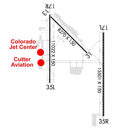
| Lat: N 3848.3 Long: W 10442.0 Elev: 6187 Var: -08 Longest Runway: 13500 | ||
| Clr Del: 134.45 Dept. ATIS: 125.0 Arr. ATIS: 125.0 Ground: 121.7 Tower: 119.9/133.15 | ||
| |||||||||||||||||||||||||||||||||||||||||||||||||||||||||||||||||||||
| |||||||||||||||||||||||||||||||||||||||||||||||||||||||||||||||||||||
| |||||||||||||||||||||||||||||||||||||||||||||||||||||||||||||||||||||
| |||||||||||||||||||||||||||||||||||||||||||||||||||||||||||||||||||||
| |||||||||||||||||||||||||||||||||||||||||||||||||||||||||||||||||||||
| |||||||||||||||||||||||||||||||||||||||||||||||||||||||||||||||||||||
| |||||||||||||||||||||||||||||||||||||||||||||||||||||||||||||||||||||
| Rwy | Rwy | |||||||
| 8270x150 | 8270' | 8270x150 | 7914' | |||||
| 13500x150 | 13500' | 109.10 - 171° | 13500x150 | 13500' | 109.10 - 352° | |||
| 11022x150 | 11022' | 11022x150 | 11022' | 109.90 - 351° | ||||
| Runway ID | Single Wheel | Double Wheel | Double Tandem Wheel | Dual Double Wheel |
| 13/31 | 120,000 | 171,000 | 279,000 | 691,000 |
| 17L/35R | 120,000 | 250,000 | 550,000 | 1,120,000 |
| 17R/35L | 120,000 | 250,000 | 550,000 | 1,120,000 |
| These numbers are Advisory and are not limits. The Airport Manager should have more accurate Weight Limits | ||||
 Airport Diagram might not be current. | |
| Facility Name: | CITY OF COLORADO SPRINGS MUNI |
| City Name: | COLORADO SPRINGS |
| County: | EL PASO |
| State abbrev: | CO |
| State Name: | COLORADO |
| Ownership: | PUBLICLY OWNED |
| Use: | OPEN TO THE PUBLIC |
| Owner's Name: | CITY OF COLORADO SPRINGS |
| Address: | 7770 MILTON E PROBY PKWY, SUITE 50 |
| COLORADO SPRINGS, CO 80916 | |
| Owner's Phone: | (719) 550-1919 |
| Manager's Name: | ALEXANDRU KOVACS |
| Address: | 7770 MILTON E PROBY PKWY, SUITE 50 |
| COLORADO SPRINGS, CO 80916 | |
| Phone: | (719) 550-1900 |
| FAA Region: | NORTHWEST MOUNTAIN |
| FAA Field Office: | DEN |

| Date | Sunrise | Sunset |
|---|---|---|
| 06/08/26 Monday | 5:34 | 20:22 |
| 06/09/26 Tuesday | 5:33 | 20:23 |
| 06/10/26 Wednesday | 5:33 | 20:23 |
| 06/11/26 Thursday | 5:33 | 20:24 |
| 06/12/26 Friday | 5:33 | 20:24 |
| 06/13/26 Saturday | 5:33 | 20:25 |
| 06/14/26 Sunday | 5:33 | 20:25 |
| 06/15/26 Monday | 5:33 | 20:25 |
| 06/16/26 Tuesday | 5:33 | 20:26 |
| 06/17/26 Wednesday | 5:33 | 20:26 |
| 06/18/26 Thursday | 5:33 | 20:26 |
| 06/19/26 Friday | 5:33 | 20:27 |
| 06/20/26 Saturday | 5:34 | 20:27 |
| 06/21/26 Sunday | 5:34 | 20:27 |
| Airport Attendance Schedule | CONTINUOUS |
| Airport Status | OPERATIONAL (This Status can change at any time - please check NOTAMS) |
| Airport Lighting Schedule | ACTVT REIL RWY 13 & 31, 17R - CTC COS ATCT. |
| Airport Storage Available | Tie Downs, Hanger |
| Extra Services Available | Air Freight, Air Ambulance, Avionics, Cargo Handling, Charter, Flight Instruction, Aircraft Rental, Aircraft Sales, Annual Surveying |
| Wind Indicator | YES - (unlit) |
| Control Tower | YES |
| CTAF Frequency | |
| Unicom Frequency | 122.950 |
| Rotating Beacon Color | WG |
| Segmented Circle | NO |
| Landing Fee | YES |
| Airport Inspected | FEDERAL - performed by FAA AIRPORTS FIELD PERSONNEL |
| Inspection Date | 03/13/2026 |
| Type of Fuel Available | Grade 100LL, JET A (freeze point -40C) |
| Airframe Repair Service | MAJOR |
| Power Plant Repair Service | MAJOR |
| Latitude | N3848.3 |
| Longitude | W10442.0 (ESTIMATED) |
| Arpt Elevation | 6187ft (SURVEYED) |
| Magnetic Variation | 08E |
| 6 miles SE | of COLORADO SPRINGS |
| Traffic Pattern Altitude | |
| Sectional Chart | DENVER |
| Operations (Reported) | Yearly | Avg. Daily |
|---|---|---|
| General Aviation Transient | 0 | 0 |
| General Aviation Local | 0 | 0 |
| Air Taxi | 0 | 0 |
| Commerical | 0 | 0 |
| Commuter | 0 | 0 |
| Military | 0 | 0 |
| Aircraft based on Field | |
|---|---|
| General Aviation Singles | 0 |
| General Aviation Multi | 0 |
| Jet Aircraft | 0 |
| General Aviation Helicopters | 0 |
| Military Aircraft | 0 |
| Gliders | 0 |
| Ultralights | 0 |
| FSS on field | NO |
| FSS tie-in | DENVER |
| FSS Phone | 1-800-WX-BRIEF |
| Who issues Notams | COS |
| Notam D service at airport | YES |
| ARTCC Name | DENVER |
| Airport Certification | AIRPORT RECEIVING SCHEDULED AIR CARRIER SERVICE FROM CARRIERS CERTIFICATED BY THE CIVIL AERONAUTICS BOARD |
| Aircraft Rescue & Firefighting Index | AIRPORT HAS A CERTIFICATE UNDER CFR PART 139 |
| Airport of Entry | No |
| Custom Landing Rights | YES |
| Joint Civil/Military | No |
| Military Landing rights | YES |
| NATIONAL PLAN OF INTEGRATED AIRPORT SYSTEMS (NPIAS) |
| GRANT AGREEMENTS UNDER FAAP/ADAP/AIP |
| SURPLUS PROPERTY AGREEMENT UNDER PUBLIC LAW 289 |
| ASSURANCES PURSUANT TO TITLE VI, CIVIL RIGHTS ACT OF 1964 |
| CUSTOMS AVBL FOR ALL MIL/CIVILIAN ACFT. CONTACT US CUSTOMS 719-574-6607. |
| OIL: O-133-148-156(MIL). |
| PORTIONS OF TWYS A, B, E, F, G, AND M ARE BLOCKED FROM VIEW FROM THE TOWER BY OBSTRUCTIONS. PORTIONS OF TWY C AND RY 17R/35L ARE BLOCKED FROM VIEW FROM THE TOWER WHEN THE INFIELD MILITARY OPERATING SFC IS OCCUPIED BY A C17 OR C5. |
| WATERFOWL AND MIGRATORY BIRD ACTIVITY ON AND INVOF ARPT. |
| A/DACG RAMP LIGHT 140 FT AGL. |
| BE ALERT; INTENSIVE USAF STUDENT TRAINING INVOF COLORADO SPRINGS & PUEBLO COLORADO. |
| CTN: ACFT WITH WINGSPAN GREATER THAN 117 FT; WHEN TAXI ON CNTRLN A2, A3, A4, USE OVERSTEER IN TURNS DUE TO INSUFFICIENT CORNER FILLETS IN PAVEMENT. |
| PPR RQR FOR ALL TRAN ACFT - CTC AFLD MGT DSN 834-4778/9 C719-556-4778/9. AFLD MGMT OPR 1300-0500++, CLSD HOL. |
| TURBO JET TRNG FLTS PROHIBITED 2300-0600. |
| MILITARY: TRAN ALERT-FORT CARSON ARRIVAL/DEPARTURE AIR CONTROL GROUP (ADACG) MSN, CTC DSN 532-8002/3 OR C719-503-8002/3. ALL TRAN ACFT CTC HIGH COUNTRY 30 MIN PRIOR TO ARR. TRAN ACFT CTC COLORADO SPRINGS RGNL COMD POST (CALLSIGN: HIGH COUNTRY) WITH ATA AND ATD. |
| MISC-FAA ATCT WILL PROVIDE MIL RCR O/R. CARGO AND PAX SVC AVBL ONLY ON PETERSON RAMP 1330-2330Z++ WKD. CLSD WKEND AND HOL UNLESS COORD 72 HR PRIOR. CTC PAX SVC AT DSN 834-4521/9021 OR C719-556-4521/9021. |
| FUEL-A++(MIL) |
| MISC-WX OPR H24 INCL WKEND; ++ CTC 834-4337, C 719-556-4337. OBSN AND FCST BY NWS KCOS. LLWASL KPEF WATCH, WARNING, ADZY. |
| WHEN CROSSING RWY 17R/35L FROM A1 TO B1 OR B1 TO A1, BE AWARE YOU WILL NOT SEE A1 OR B1 DEPENDING ON DIRECTION CROSSING UNTIL YOU CREST RWY 17R/35L. WHEN CROSSING FROM A1 TO B1 TRAVEL NE AND FROM B1 TO A1 TRAVEL SW. |
| AF: ACFT TRANSPORTING HAZ CARGO CTC AFLD MGMT ON 318.05 30 MIN PRIOR TO ARR. |
| MILITARY: RSTD: DUE TO LIMITED PRKG AND POTENTIAL TO DMG LGT, UNSECURED ACFT, MOBILITY ACFT ARE NOT PERMITTED TO USE COLORADO SPRINGS FBO UNLESS FBO CAN GUARANTEE SUFFICIENT PRKG CLNC THAT BLAST FM ENG THRUST AND REVERSE THRUST WILL NOT IMPACT OTR ACFT, GND PSNL, OR EQPT. |
| B52 OPNS PROHIBITED. |
| LGTD WDI APCH RWY 17L/35R, 17R/35L & 13/31. |
| JASU: 2(AM32A-95) 2MA32A-60A 2(MA32-86A) 1(SGNC) 2(B809D-GENERATORS). |
| RWY 13/3 1 PCR VALUE: 460/F/C/X/T |
| RWY 17L/ 35RPCR VALUE: 1060/R/B/W/T |
| RWY 17R/ 35LPCR VALUE: 1160/F/A/X/T |
Airport Communications & Frequencies:
| |||||||||||||||||||||||||||||||||||||||||||||
| Runway: 13 | Runway: 31 | ||
| Mag heading: | 127° | Mag heading: | 307° |
| Rwy Slope: | -.44% Down | Rwy Slope: | .44% Up |
| Approach: | Approach: | ||
| Pattern: | Left Traffic | Pattern: | Left Traffic |
| Markings: | NONPRECISION INSTRUMENT | Markings: | NONPRECISION INSTRUMENT |
| Marking Condition: | GOOD | Marking Condition: | GOOD |
| Arresting Dev: | MA-1A | Arresting Dev: | MA-1A MOD |
| Lat & Long: | N3849.4 W10442.9 | Lat. & Long.: | N3848.4 W10441.7 |
| Elev: | 6173.1 ft. MSL | Elev: | 6137.1 ft. MSL |
| TCH: | 64 ft. AGL | TCH: | 52 ft. AGL |
| Visual Glide Path: | 3.00 degrees | Visual Glide Path: | 3.04 degrees |
| Displaced Threshold: | No | Displaced Threshold: | 356 feet |
| Touchdown Zone: | YES | Touchdown Zone: | YES |
| Touchdown Elev.: | 6173.2 feet | Touchdown Elev.: | 6156.3 feet |
| Visual Glide Slope: | 4-Light PAPI on RIGHT side of Runway | Visual Glide Slope: | 4-Light PAPI on LEFT side of Runway |
| RVR Equipment: | RVR Equipment: | ||
| RVV Equipment: | NO | RVV Equipment: | NO |
| Approach Lights: | Approach Lights: | ||
| REIL: | YES | REIL: | YES |
| Centerline Lights: | NO | Centerline Lights: | NO |
| Touchdown lights: | NO | Touchdown lights: | NO |
| Runway Category: | Runway with a Visual Approach | Runway Category: | Runway with a Non-precision Approach having visibility minimums greater than 3/4 mile |
| Declared Distances: | TORA:8270' TODA:8270' ASDA:8270' LDA:8270' | Declared Distances: | TORA:8270' TODA:8270' ASDA:8270' LDA:7914' |
| Obstructions: | Obstructions: | HILL | |
| Marked: | Marked: | NOT Marked/Lighted | |
| Clearance slope: | 50:1 | Clearance slope: | 20:1 |
| Obstruction height: | Obstruction height: | 10 feet AGL | |
| Dist. from runway: | Dist. from runway: | 400 feet | |
| Centerline offset: | Centerline offset: | 340 feet left of centerline | |
| Comments: | Comments: |
| Runway: 17L | Runway: 35R | ||
| Mag heading: | 172° | Mag heading: | 352° |
| Rwy Slope: | -.62% Down | Rwy Slope: | .62% Up |
| Approach: | ILS/DME | Approach: | ILS/DME |
| Pattern: | Left Traffic | Pattern: | Left Traffic |
| Markings: | PRECISION INSTRUMENT | Markings: | PRECISION INSTRUMENT |
| Marking Condition: | GOOD | Marking Condition: | GOOD |
| Arresting Dev: | Arresting Dev: | ||
| Lat & Long: | N3849.0 W10441.1 | Lat. & Long.: | N3846.7 W10441.1 |
| Elev: | 6187.0 ft. MSL | Elev: | 6102.7 ft. MSL |
| TCH: | 57 ft. AGL | TCH: | 71 ft. AGL |
| Visual Glide Path: | 3.00 degrees | Visual Glide Path: | 3.00 degrees |
| Displaced Threshold: | No | Displaced Threshold: | No |
| Touchdown Zone: | YES | Touchdown Zone: | YES |
| Touchdown Elev.: | 6187.0 feet | Touchdown Elev.: | 6117.7 feet |
| Visual Glide Slope: | 4-Light PAPI on LEFT side of Runway | Visual Glide Slope: | 4-Light PAPI on RIGHT side of Runway |
| RVR Equipment: | TOUCHDOWN-ROLLOUT | RVR Equipment: | TOUCHDOWN-ROLLOUT |
| RVV Equipment: | NO | RVV Equipment: | NO |
| Approach Lights: | MALSR - 1,400 foot medium intensity approach lighting system with runway alignment indicator lights | Approach Lights: | |
| REIL: | NO | REIL: | YES |
| Centerline Lights: | YES | Centerline Lights: | YES |
| Touchdown lights: | YES | Touchdown lights: | YES |
| Runway Category: | Precision Instrument Runway | Runway Category: | Precision Instrument Runway |
| Declared Distances: | TORA:13501' TODA:13501' ASDA:13501' LDA:13501' | Declared Distances: | TORA:13501' TODA:13501' ASDA:13501' LDA:13501' |
| Runway: 17R | Runway: 35L | ||
| Mag heading: | 172° | Mag heading: | 352° |
| Rwy Slope: | -1.19% Down | Rwy Slope: | 1.19% Up |
| Approach: | Approach: | ILS | |
| Pattern: | Left Traffic | Pattern: | Left Traffic |
| Markings: | PRECISION INSTRUMENT | Markings: | PRECISION INSTRUMENT |
| Marking Condition: | GOOD | Marking Condition: | GOOD |
| Arresting Dev: | Arresting Dev: | ||
| Lat & Long: | N3849.4 W10443.0 | Lat. & Long.: | N3847.6 W10443.0 |
| Elev: | 6176.4 ft. MSL | Elev: | 6045.0 ft. MSL |
| TCH: | 49 ft. AGL | TCH: | 72 ft. AGL |
| Visual Glide Path: | 3.00 degrees | Visual Glide Path: | 3.00 degrees |
| Displaced Threshold: | No | Displaced Threshold: | No |
| Touchdown Zone: | YES | Touchdown Zone: | YES |
| Touchdown Elev.: | 6176.4 feet | Touchdown Elev.: | 6074.6 feet |
| Visual Glide Slope: | 4-Light PAPI on LEFT side of Runway | Visual Glide Slope: | 4-Light PAPI on LEFT side of Runway |
| RVR Equipment: | TOUCHDOWN-ROLLOUT | RVR Equipment: | TOUCHDOWN-ROLLOUT |
| RVV Equipment: | NO | RVV Equipment: | NO |
| Approach Lights: | Approach Lights: | MALSR - 1,400 foot medium intensity approach lighting system with runway alignment indicator lights | |
| REIL: | YES | REIL: | NO |
| Centerline Lights: | NO | Centerline Lights: | NO |
| Touchdown lights: | NO | Touchdown lights: | NO |
| Runway Category: | D | Runway Category: | Precision Instrument Runway |
| Declared Distances: | TORA:11022' TODA:11022' ASDA:11022' LDA:11022' | Declared Distances: | TORA:11022' TODA:11022' ASDA:11022' LDA:11022' |
Thanks for using FltPlan.com
all rights reserved © 1999-2026 by Flight Plan LLC