
| CLOQUET CARLTON COUNTY CLOQUET MN |
| |
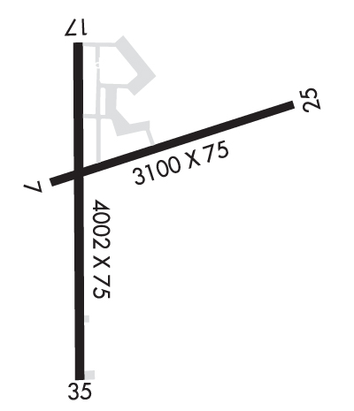
| Lat: N 4642.1 Long: W 09230.2 Elev: 1279 Var: +01 Longest Runway: 4002 | ||
| Clr Del: 122.15 AWOS: 118.52 CTAF: 122.8 | ||
| ||||||||||||||||||||||||||||||||||||||||||||
| ||||||||||||||||||||||||||||||||||||||||||||
| ||||||||||||||||||||||||||||||||||||||||||||
| Rwy | Rwy | |||||||
| 3100x75 | 3100' | 3100x75 | 3100' | |||||
| 4002x75 | 4002' | 4002x75 | 4002' | |||||
| Runway ID | Single Wheel | Double Wheel | Double Tandem Wheel | Dual Double Wheel |
| 07/25 | N/A | N/A | N/A | N/A |
| 18/36 | 8,000 | 12,000 | N/A | N/A |
| These numbers are Advisory and are not limits. The Airport Manager should have more accurate Weight Limits | ||||
 Airport Diagram might not be current. | |
| Facility Name: | CLOQUET/CARLTON COUNTY |
| City Name: | CLOQUET |
| County: | CARLTON |
| State abbrev: | MN |
| State Name: | MINNESOTA |
| Ownership: | PUBLICLY OWNED |
| Use: | OPEN TO THE PUBLIC |
| Owner's Name: | CARLTON COUNTY |
| Address: | 1630 COUNTY ROAD 61 |
| CARLTON, MN 55718-8170 | |
| Owner's Phone: | 218-384-9151 |
| Manager's Name: | QUINTEN ANDERSON |
| Address: | 125 WHEATON RD |
| CLOQUET, MN 55720-9504 | |
| Phone: | 218-879-4911 |
| FAA Region: | GREAT LAKES |
| FAA Field Office: | DMA |
| Date | Sunrise | Sunset |
|---|---|---|
| 06/08/26 Monday | 5:17 | 21:01 |
| 06/09/26 Tuesday | 5:17 | 21:02 |
| 06/10/26 Wednesday | 5:16 | 21:03 |
| 06/11/26 Thursday | 5:16 | 21:03 |
| 06/12/26 Friday | 5:16 | 21:04 |
| 06/13/26 Saturday | 5:16 | 21:04 |
| 06/14/26 Sunday | 5:16 | 21:05 |
| 06/15/26 Monday | 5:16 | 21:05 |
| 06/16/26 Tuesday | 5:16 | 21:06 |
| 06/17/26 Wednesday | 5:16 | 21:06 |
| 06/18/26 Thursday | 5:16 | 21:07 |
| 06/19/26 Friday | 5:16 | 21:07 |
| 06/20/26 Saturday | 5:16 | 21:07 |
| 06/21/26 Sunday | 5:16 | 21:07 |
| Airport Attendance Schedule | MON-SAT 0800-1700; FOR SVC AFT HRS CALL 218-393-2405. |
| Airport Status | OPERATIONAL (This Status can change at any time - please check NOTAMS) |
| Airport Lighting Schedule | ACTVT ODALS RWY 36; REIL RWY 18 & 36; PAPI RWY 18 & 36; MIRL RWY 18/36 & 07/25 - CTAF. |
| Airport Storage Available | Tie Downs |
| Extra Services Available | Flight Instruction, Aircraft Rental, Aircraft Sales, Annual Surveying |
| Wind Indicator | YES - (lighted) |
| Control Tower | NO |
| CTAF Frequency | 122.800 |
| Unicom Frequency | 122.800 |
| Rotating Beacon Color | WG |
| Segmented Circle | NO |
| Landing Fee | NO |
| Airport Inspected | STATE - performed by STATE AERONAUTICAL PERSONNEL |
| Inspection Date | 05/24/2023 |
| Type of Fuel Available | Grade 100LL, JET A (freeze point -40C); -10FUEL AVBL H24 SELF SVC VIA CREDIT CARD. |
| Airframe Repair Service | MAJOR |
| Power Plant Repair Service | MAJOR |
| Latitude | N4642.1 |
| Longitude | W09230.2 (ESTIMATED) |
| Arpt Elevation | 1279ft (SURVEYED) |
| Magnetic Variation | 01W |
| 3 miles SW | of CLOQUET |
| Traffic Pattern Altitude | |
| Sectional Chart | GREEN BAY |
| Operations (Reported) | Yearly | Avg. Daily |
|---|---|---|
| General Aviation Transient | 0 | 0 |
| General Aviation Local | 0 | 0 |
| Air Taxi | 0 | 0 |
| Commerical | 0 | 0 |
| Commuter | 0 | 0 |
| Military | 0 | 0 |
| Aircraft based on Field | |
|---|---|
| General Aviation Singles | 0 |
| General Aviation Multi | 0 |
| Jet Aircraft | 0 |
| General Aviation Helicopters | 0 |
| Military Aircraft | 0 |
| Gliders | 0 |
| Ultralights | 0 |
| FSS on field | NO |
| FSS tie-in | PRINCETON |
| FSS Phone | 1-800-WX-BRIEF |
| Who issues Notams | COQ |
| Notam D service at airport | YES |
| ARTCC Name | MINNEAPOLIS |
| Airport Certification | |
| Aircraft Rescue & Firefighting Index | None |
| Airport of Entry | No |
| Custom Landing Rights | No |
| Joint Civil/Military | No |
| Military Landing rights | YES |
| NATIONAL PLAN OF INTEGRATED AIRPORT SYSTEMS (NPIAS) |
| GRANT AGREEMENTS UNDER FAAP/ADAP/AIP |
| ASSURANCES PURSUANT TO TITLE VI, CIVIL RIGHTS ACT OF 1964 |
| WILDLIFE ON & INVOF ARPT. |
| FOR CD CTC DULUTH APCH AT 218-740-5950. |
| NOISE ABATEMENT: AVOID OVR FLT OF SCHOOL & OFC BLDGS; 0.5 NM NW DEP END RWY 36. |
| RWY 18 PREFERRED CALM WIND RWY. |
Airport Communications & Frequencies:
| ||||||||||||||||
| Runway: 07 | Runway: 25 | ||
| Mag heading: | 74° | Mag heading: | 254° |
| Rwy Slope: | -.32% Down | Rwy Slope: | .32% Up |
| Approach: | Approach: | ||
| Pattern: | Left Traffic | Pattern: | Left Traffic |
| Markings: | NONPRECISION INSTRUMENT | Markings: | NONPRECISION INSTRUMENT |
| Marking Condition: | GOOD | Marking Condition: | GOOD |
| Arresting Dev: | Arresting Dev: | ||
| Lat & Long: | N4642.1 W09230.4 | Lat. & Long.: | N4642.2 W09229.7 |
| Elev: | 1276.7 ft. MSL | Elev: | 1266.9 ft. MSL |
| TCH: | TCH: | ||
| Visual Glide Path: | Visual Glide Path: | ||
| Displaced Threshold: | No | Displaced Threshold: | No |
| Touchdown Zone: | YES | Touchdown Zone: | YES |
| Touchdown Elev.: | 1278.2 feet | Touchdown Elev.: | 1278.2 feet |
| Visual Glide Slope: | Visual Glide Slope: | ||
| RVR Equipment: | RVR Equipment: | ||
| RVV Equipment: | NO | RVV Equipment: | NO |
| Approach Lights: | Approach Lights: | ||
| REIL: | NO | REIL: | NO |
| Centerline Lights: | NO | Centerline Lights: | NO |
| Touchdown lights: | NO | Touchdown lights: | NO |
| Runway Category: | Runway with a Visual Approach | Runway Category: | Runway with a Visual Approach |
| Declared Distances: | Declared Distances: |
| Runway: 18 | Runway: 36 | ||
| Mag heading: | 180° | Mag heading: | 360° |
| Rwy Slope: | -.16% Down | Rwy Slope: | .16% Up |
| Approach: | Approach: | ||
| Pattern: | Left Traffic | Pattern: | Left Traffic |
| Markings: | NONPRECISION INSTRUMENT | Markings: | NONPRECISION INSTRUMENT |
| Marking Condition: | GOOD | Marking Condition: | GOOD |
| Arresting Dev: | Arresting Dev: | ||
| Lat & Long: | N4642.3 W09230.3 | Lat. & Long.: | N4641.7 W09230.3 |
| Elev: | 1278.4 ft. MSL | Elev: | 1272.1 ft. MSL |
| TCH: | 30 ft. AGL | TCH: | 30 ft. AGL |
| Visual Glide Path: | 3.00 degrees | Visual Glide Path: | 3.00 degrees |
| Displaced Threshold: | No | Displaced Threshold: | No |
| Touchdown Zone: | YES | Touchdown Zone: | YES |
| Touchdown Elev.: | 1279.1 feet | Touchdown Elev.: | 1278.5 feet |
| Visual Glide Slope: | 4-Light PAPI on LEFT side of Runway | Visual Glide Slope: | 4-Light PAPI on LEFT side of Runway |
| RVR Equipment: | RVR Equipment: | ||
| RVV Equipment: | NO | RVV Equipment: | NO |
| Approach Lights: | Approach Lights: | ODALS - omnidirectional approach lighting system | |
| REIL: | YES | REIL: | YES |
| Centerline Lights: | NO | Centerline Lights: | NO |
| Touchdown lights: | NO | Touchdown lights: | NO |
| Runway Category: | Runway with a Non-precision Approach | Runway Category: | Runway with a Non-precision Approach |
| Declared Distances: | Declared Distances: |
Thanks for using FltPlan.com
all rights reserved © 1999-2026 by Flight Plan LLC
