| MERRITT ISLAND MERRITT ISLAND FL |
| |
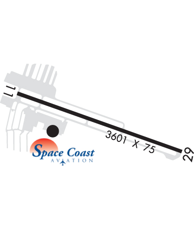
| Lat: N 2820.5 Long: W 08041.1 Elev: 6 Var: +05 Longest Runway: 3601 | ||
| AWOS: 119.02 CTAF: 122.97 | ||
| |||||||||||||||||||||||||||||||||||||||||||||||||||||||||||||
| |||||||||||||||||||||||||||||||||||||||||||||||||||||||||||||
| |||||||||||||||||||||||||||||||||||||||||||||||||||||||||||||
| Rwy | Rwy | |||||||
| 3601x75 | 3601' | 3601x75 | 3601' | |||||
| Runway ID | Single Wheel | Double Wheel | Double Tandem Wheel | Dual Double Wheel |
| 11/29 | 22,000 | N/A | N/A | N/A |
| These numbers are Advisory and are not limits. The Airport Manager should have more accurate Weight Limits | ||||
 Airport Diagram might not be current. | |
| Facility Name: | MERRITT ISLAND |
| City Name: | MERRITT ISLAND |
| County: | BREVARD |
| State abbrev: | FL |
| State Name: | FLORIDA |
| Ownership: | PUBLICLY OWNED |
| Use: | OPEN TO THE PUBLIC |
| Owner's Name: | TITUSVILLE-COCOA AIRPORT DISTRICT |
| Address: | 355 GOLDEN KNIGHTS BLVD |
| TITUSVILLE, FL 32780 | |
| Owner's Phone: | 321-267-8780 |
| Manager's Name: | MICHAEL POWELL |
| Address: | 355 GOLDEN KNIGHTS BLVD |
| TITUSVILLE, FL 32780 | |
| Phone: | 321-267-8780; 321-453-2222. |
| FAA Region: | SOUTHERN |
| FAA Field Office: | ORL |

| Date | Sunrise | Sunset |
|---|---|---|
| 09/24/21 Friday | 7:12 | 19:17 |
| 09/25/21 Saturday | 7:12 | 19:16 |
| 09/26/21 Sunday | 7:13 | 19:15 |
| 09/27/21 Monday | 7:13 | 19:14 |
| 09/28/21 Tuesday | 7:14 | 19:12 |
| 09/29/21 Wednesday | 7:15 | 19:11 |
| 09/30/21 Thursday | 7:15 | 19:10 |
| 10/01/21 Friday | 7:16 | 19:09 |
| 10/02/21 Saturday | 7:16 | 19:08 |
| 10/03/21 Sunday | 7:17 | 19:07 |
| 10/04/21 Monday | 7:17 | 19:05 |
| 10/05/21 Tuesday | 7:18 | 19:04 |
| 10/06/21 Wednesday | 7:18 | 19:03 |
| 10/07/21 Thursday | 7:19 | 19:02 |
| Airport Attendance Schedule | 7 Days A Week 0800-2000 |
| Airport Status | OPERATIONAL (This Status can change at any time - please check NOTAMS) |
| Airport Lighting Schedule | ACTVT MIRL RWY 11/29 - CTAF.; ACTVT ROTG BCN - CTAF. |
| Airport Storage Available | Tie Downs |
| Extra Services Available | Avionics, Flight Instruction, Aircraft Rental |
| Wind Indicator | YES - (lighted) |
| Control Tower | NO |
| CTAF Frequency | 122.975 |
| Unicom Frequency | 122.975 |
| Rotating Beacon Color | CLEAR-GREEN (Light Land Airport) |
| Segmented Circle | Y-L |
| Landing Fee | NO |
| Airport Inspected | STATE - performed by STATE AERONAUTICAL PERSONNEL |
| Inspection Date | 08/15/2018 |
| Type of Fuel Available | Grade 100LL, JET A (freeze point -40C) |
| Airframe Repair Service | MAJOR |
| Power Plant Repair Service | MAJOR |
| Latitude | N2820.5 |
| Longitude | W08041.1 (ESTIMATED) |
| Arpt Elevation | 5ft (SURVEYED) |
| Magnetic Variation | 05W |
| 0 miles S | of MERRITT ISLAND |
| Traffic Pattern Altitude | |
| Sectional Chart | JACKSONVILLE |
| Operations (Reported) | Yearly | Avg. Daily |
|---|---|---|
| General Aviation Transient | 48000 | 132 |
| General Aviation Local | 64000 | 175 |
| Air Taxi | 1500 | 4 |
| Commerical | 0 | 0 |
| Commuter | 0 | 0 |
| Military | 0 | 0 |
| Aircraft based on Field | |
|---|---|
| General Aviation Singles | 38 |
| General Aviation Multi | 7 |
| Jet Aircraft | 0 |
| General Aviation Helicopters | 5 |
| Military Aircraft | 0 |
| Gliders | 0 |
| Ultralights | 0 |
| FSS on field | NO |
| FSS tie-in | SAINT PETERSBURG |
| FSS Phone | 1-800-WX-BRIEF |
| Who issues Notams | PIE |
| Notam D service at airport | YES |
| ARTCC Name | MIAMI |
| Airport Certification | |
| Aircraft Rescue & Firefighting Index | None |
| Airport of Entry | No |
| Custom Landing Rights | YES |
| Joint Civil/Military | No |
| Military Landing rights | YES |
| NATIONAL PLAN OF INTEGRATED AIRPORT SYSTEMS (NPIAS) |
| GRANT AGREEMENTS UNDER FAAP/ADAP/AIP |
| ASSURANCES PURSUANT TO TITLE VI, CIVIL RIGHTS ACT OF 1964 |
| THIS AIRPORT HAS BEEN SURVEYED BY THE NATIONAL GEODETIC SURVEY. |
| BANNER TOWING. |
| 24 HR HELI OPS SW RAMP. |
| PATRICK AFB (KCOF) CLASS D AIRSPACE IN CLOSE PROXIMITY; KCOF CROSSING RWY 11/29 HAS SAME ORIENTATION AS MERRITT ISLAND ARPT. |
| FOR CD OR TO CNL IFR CTC ORLANDO APCH AT 407-825-3398. |
| NOISE SENSITIVE ARPT. VOLUNTARY NOISE ABATEMENT PROC IN EFCT. CLIMB OUT AT BEST ANGLE (VX), TURN CROSSWIND AT 700 FT (MID-RIVER, IF POSS) & MERGE WITH DOWNWIND TFC AT 1000 FT PAT ALT. NO TOUCH-AND-GO OPS BTN 8 PM AND 8 AM. NO REPETITIVE FLT OPS AT THE ARPT BTN 8 PM AND 7 AM. NO REPETITIVE FLT T OPS ON SUN AND NTL HOLS. IN LIEU OF TOUCH-AND-GO OPS PERFORM FULL STOP, TAXI-BACK OPS. AVOID FLYING AT LOW ALTS OVR NOISE SENSITIVE AREAS (NEWFOUND HARBOR DR). |
| RWY L CG N 038007000005000000000 001500064000048000 08/15/2018NGS 06/17/2005NGS 06/17/2005 TIE AVNCS,INSTR,RNTL Y-LKCOI N |
Airport Communications & Frequencies:
| ||||||||||||||||||||||
| Runway: 11 | Runway: 29 | ||
| Mag heading: | 114° | Mag heading: | 294° |
| Rwy Slope: | -.08% Down | Rwy Slope: | .08% Up |
| Approach: | Approach: | ||
| Pattern: | Left Traffic | Pattern: | Left Traffic |
| Markings: | NONPRECISION INSTRUMENT | Markings: | NONPRECISION INSTRUMENT |
| Marking Condition: | GOOD | Marking Condition: | GOOD |
| Arresting Dev: | Arresting Dev: | ||
| Lat & Long: | N2820.6 W08041.4 | Lat. & Long.: | N2820.4 W08040.8 |
| Elev: | 5.9 ft. MSL | Elev: | 2.9 ft. MSL |
| TCH: | 42 ft. AGL | TCH: | 41 ft. AGL |
| Visual Glide Path: | 3.00 degrees | Visual Glide Path: | 3.00 degrees |
| Displaced Threshold: | No | Displaced Threshold: | No |
| Touchdown Zone: | YES | Touchdown Zone: | YES |
| Touchdown Elev.: | 5.9 feet | Touchdown Elev.: | 5.4 feet |
| Visual Glide Slope: | 2-Light PAPI on LEFT side of Runway | Visual Glide Slope: | 2-Light PAPI on LEFT side of Runway |
| RVR Equipment: | RVR Equipment: | ||
| RVV Equipment: | NO | RVV Equipment: | NO |
| Approach Lights: | Approach Lights: | ||
| REIL: | NO | REIL: | NO |
| Centerline Lights: | NO | Centerline Lights: | NO |
| Touchdown lights: | NO | Touchdown lights: | NO |
| Runway Category: | Runway with a Non-precision Approach | Runway Category: | Runway with a Visual Approach |
| Declared Distances: | Declared Distances: | ||
| Obstructions: | BLDG | Obstructions: | BOAT |
| Marked: | NOT Marked/Lighted | Marked: | NOT Marked/Lighted |
| Clearance slope: | 1:1; APCH SLOPE 20:1 TO THE DSPLCD THLD. | Clearance slope: | 20:1 |
| Obstruction height: | 20 feet AGL | Obstruction height: | 25 feet AGL |
| Dist. from runway: | 122 feet | Dist. from runway: | 700 feet |
| Centerline offset: | 250 left of centerline | Centerline offset: | 250 feet right of centerline |
| Comments: | UNLGT OBS IN APCH; 20 FT BLDG 122 FT FM RWY 250 FT L. | Comments: |
Thanks for using FltPlan.com
all rights reserved © 1999-2021 by Flight Plan LLC