
| PATRICK AFB COCOA BEACH FL |
| |
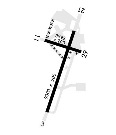
| Lat: N 2814.1 Long: W 08036.6 Elev: 8 Var: +07 Longest Runway: 9008 | ||
| Clr Del: 118.4 Dept. ATIS: 119.17 Arr. ATIS: 119.17 Ground: 124.35 Tower: 133.75 | ||
| ||||||
|
| Rwy | Rwy | |||||||
| 9008x200 | 9008' | 109.10 - 026° | 9008x200 | 9008' | 110.90 - 206° | |||
| 3993x200 | 3993' | 3993x200 | 3692' | |||||
| Runway ID | Single Wheel | Double Wheel | Double Tandem Wheel | Dual Double Wheel |
| 03/21 | N/A | N/A | N/A | N/A |
| 11/29 | N/A | N/A | N/A | N/A |
| These numbers are Advisory and are not limits. The Airport Manager should have more accurate Weight Limits | ||||
 Airport Diagram might not be current. | |
| Facility Name: | PATRICK SPACE FORCE BASE |
| City Name: | COCOA BEACH |
| County: | BREVARD |
| State abbrev: | FL |
| State Name: | FLORIDA |
| Ownership: | AIR FORCE OWNED |
| Use: | PRIVATE |
| Owner's Name: | USAF |
| Address: | DEPT OF THE AF,HDQRTS ADTC |
| EGLIN AFB, FL 32542 | |
| Owner's Phone: | |
| Manager's Name: | CHIEF OF AFLD MANAGEMENT |
| Address: | DEPT OF THE AF HEADQUARTERS ADTC |
| EGLIN AFB, FL 32542 | |
| Phone: | 321-494-4028; DSN-854-2222 |
| FAA Region: | SOUTHERN |
| FAA Field Office: | ORL |
| Date | Sunrise | Sunset |
|---|---|---|
| 06/08/26 Monday | 6:25 | 20:18 |
| 06/09/26 Tuesday | 6:25 | 20:19 |
| 06/10/26 Wednesday | 6:25 | 20:19 |
| 06/11/26 Thursday | 6:25 | 20:19 |
| 06/12/26 Friday | 6:25 | 20:20 |
| 06/13/26 Saturday | 6:25 | 20:20 |
| 06/14/26 Sunday | 6:25 | 20:20 |
| 06/15/26 Monday | 6:25 | 20:21 |
| 06/16/26 Tuesday | 6:25 | 20:21 |
| 06/17/26 Wednesday | 6:25 | 20:21 |
| 06/18/26 Thursday | 6:25 | 20:22 |
| 06/19/26 Friday | 6:26 | 20:22 |
| 06/20/26 Saturday | 6:26 | 20:22 |
| 06/21/26 Sunday | 6:26 | 20:22 |
| Airport Attendance Schedule | M-F 1300-0500Z+, SAT-SUN CLSD, HOL CLSD; CLSD EVERY THIRD FRI OF THE MONTH. |
| Airport Status | OPERATIONAL (This Status can change at any time - please check NOTAMS) |
| Airport Lighting Schedule | |
| Airport Storage Available | NONE |
| Extra Services Available | NONE |
| Wind Indicator | YES - (unlit) |
| Control Tower | YES |
| CTAF Frequency | |
| Unicom Frequency | |
| Rotating Beacon Color | WG |
| Segmented Circle | NO |
| Landing Fee | NO |
| Airport Inspected | No Inspection Data Available performed by the OWNER |
| Inspection Date | Unknown |
| Type of Fuel Available | ++ |
| Airframe Repair Service | NONE |
| Power Plant Repair Service | NONE |
| Latitude | N2814.1 |
| Longitude | W08036.6 (ESTIMATED) |
| Arpt Elevation | 7ft (SURVEYED) |
| Magnetic Variation | 07W |
| 3 miles S | of COCOA BEACH |
| Traffic Pattern Altitude | TFC PAT: 1500 FT MSL RECTANGULAR, 2000 FT MSL OVHD. |
| Sectional Chart | JACKSONVILLE |
| Operations (Reported) | Yearly | Avg. Daily |
|---|---|---|
| General Aviation Transient | 0 | 0 |
| General Aviation Local | 0 | 0 |
| Air Taxi | 0 | 0 |
| Commerical | 0 | 0 |
| Commuter | 0 | 0 |
| Military | 0 | 0 |
| Aircraft based on Field | |
|---|---|
| General Aviation Singles | 0 |
| General Aviation Multi | 0 |
| Jet Aircraft | 0 |
| General Aviation Helicopters | 0 |
| Military Aircraft | 0 |
| Gliders | 0 |
| Ultralights | 0 |
| FSS on field | NO |
| FSS tie-in | SAINT PETERSBURG |
| FSS Phone | 1-800-WX-BRIEF |
| Who issues Notams | PIE |
| Notam D service at airport | YES |
| ARTCC Name | MIAMI |
| Airport Certification | |
| Aircraft Rescue & Firefighting Index | CAUTION: ARFF AVBL 4,800 GALS OF AGENT WITH 7 ARFF VEH.; CAUTION: ARFF AVBL 4800 GAL OF AGENT WITH 4 ARFF VEH. |
| Airport of Entry | No |
| Custom Landing Rights | No |
| Joint Civil/Military | No |
| Military Landing rights | No |
| CAUTION: FIRST 240 FT OF RWY 29 NOT VIS FM TWR. DUR VFR WX COND EXER CAUTION DUE TO EXTV LCL GEN AVN ACFT OVR MELBOURNE INTL 7 NM S. |
| FLUID: SP PRESAIR LHOX LOX |
| OIL: O-128-133-148 |
| TRAN ALERT: OPS 1300-0500Z++ MON-FRI; CLSD HOL. ALL TRAN ARR OR DEP RQR TRAN ALERT ASST; NO ARR AFT 0430Z. REQ FOR SVCS OUTSIDE NML HR MUST BE FWD THRU AFLD MGMT NLT 10-WORK DAYS IN ADV. |
| MISC: AMOPS DSN 854-2222; C321-494-2222; FAX C321-494-6442. |
| RSTD: E SIDE TWY C CLSD TO JET ACFT & ACFT WITH WINGSPAN ABV 133 FT. GUN BERM LTD TO A-10 ACFT OR SMLR AND REQS AFLD MGMT COORDINATION. TWY J WEST OF GUN BERM CLSD. |
| CAUTION: BIRD HAZ POTENTIAL EXISTS. MIGRATORY SEASON PHASE II 1 OCT-31 MAR. DUR BIRD WATCH COND MODERATE TKOF AND LDG PMTD; DUR BIRD WATCH COND SEVERE TKOF AND LDG NA. CTC TWR/GND/ATIS FOR CURRENT BIRD WATCH COND CODE. |
| CSTMS/AG/IMG: CSTMS LTD TO TRAN MSN IN DIRECT SUPPORT OF SLD 45 AND 920 RQW ONLY. ALL ACFT RQRG CUSTOMS SUPPORT CTC AMOPS 72 HRS PRIOR WITH PPR REQ. IF NO NTC, EXP2-3 HR DELAY. ALL ACFT RQR SUPPORT CTC PTD WITH 30 MIN OUT CALL VIA DIRECT A/G COM OR FONE PATCH. |
| OBSN AUTOMATED; FMQ-19 OBSN WX EQPMT IN USE H24. WX OBSN/FCST AVBL H24 - DSN 467-8484; C321-853-8484. BACKUP SUPPORT CTC 26 OWS AT C318-529-2651. |
| CAUTION: RWY 11/29 NONSTANDARD LZ TOUCHDOWN BOX MARKINGS. |
| RSTD: SKID LDG CONDUCTED BY BASE ASGN R/W ACFT EQUIPPED WITH SKIDS RSTRD TO TWY B S OF TWY C AND RWY 11/29 W OF RWY 03. |
| RSTD: ACFT LRGR THAN C-130, NA ON 800 RAMP & 180 DEG TURNS ON RWY 03/21 LTD TO CONC ENDS. |
| SERVICE-TRAN ALERT-FLEET SVC UNAVBL; LAV CART AVBL UPON REQ FOR AIRCREW USE. |
| MISC: COMSEC STOR NOT AVBL AT AMOPS; CTC CMD POST (BLDG 423, EXTN 7001) FOR COMSEC STOR. |
| NTSD OVRN LEN RWY 03; OVRN 1100 FT. NTSD CHEVRON MRK EXIST. MISSING CHEVRON AT INT OF TWYS A & G. |
| RSTD: RWY 29 OVRN UNUSBL. |
| CSTMS/AG/IMG: CSTMS LTD TO TRAN MSN IN DRCT SUPPORT OF SLD 45 AND 920 RQW ONLY. |
| NOISE ABATEMENT INFO - AIRFIELD OPS DSN 854-2222/C321-494-2222. |
| RSTD: ACFT WITH 188 FT WINGSPAN AND SMALLER ONLY ON TWY A BTN 800 RAMP AND RY 29. |
| CAUTION: ARFF AVBL 4,800 GALS OF AGENT WITH 7 ARFF VEH. |
| MISC: BASE TRAN ONLY AVBL MON-FRI 1200-2100++. CLSD WKEND. PAX TRML AVBL MON 1100-1900Z++,WED 1230-2130Z++, AND TUE, THU, FRI 1430-2300Z++. |
| SERVICE-LGT: TWY A EDGE LGT BTN TWY B & L APRX 17 FT-78 FT FM USBL TWY SFC. |
| RSTD: TWY A BTN TWY L AND RWY 21 UNDERRUN RSTD TO C130 ACFT. |
| COMD POST DOES NOT HAVE ABILITY TO ACVT AFLD LTG AFT AFLD HR. |
| UHF UNREL. |
| HVY ACFT MUST PROVIDE OWN TOW BAR. |
| TFC PAT: TRAN ACFT PAT WORK NOT AUTH FM 0300-1300++ (2200-0800 LCL). |
| FUEL: LTD FUEL CPBLTY AVBL FOR TRAN ACFT DUE TO CONST OF FUELS STORAGE AREA - C321-494-5535/DSN 854-5535/1365. |
| RSTD: OFFL BUS - 72 HRS NTC RQRD FOR PPR - CTC AMOPS AT DSN 854-2222/2223. PPR VALID +/- 30 MIN FR ETA. |
| AIRFIELD LGTS-OUT OPS MAY BE IN PROG ON NON-INTFC BASIS WITH NON-PTCPG ACFT. |
| JASU; 3(MA-1A); 5(MD-3B). |
| RSTD: 301 RQS CARGO SLING LOAD AREA LCTD AT GRASSY AREA NW OF APCH END RWY 11 ALONG BANANA RIVER SHORELINE N28 14 38, W 80 36 57 IS AUTH FOR USE BY 920 RQW HH-60 ACFT. COOR WITH AFLD MGMT RQR PRIOR TO USE. WHEN CONDUCTING CARGO SLING LOAD OPS, OVFT OF PERS, VEH, ND PRK ACFT NOT AUTH. |
| RSTD - NON STD SAFETY CIRCLE MRK LCD ON 750 RAMP. |
| CAUTION: ARFF AVBL 4800 GAL OF AGENT WITH 4 ARFF VEH. |
| RWY 21 CAUTION: NON-STD THR LGT. |
| RWY 03/2 1 FIRST 1000 FT GROOVED CONC; MID 7000 FT ASPHALT. |
Airport Communications & Frequencies:
| |||||||||||||||||||||||||||||||||||
| Runway: 03 | Runway: 21 | ||
| Mag heading: | 27° | Mag heading: | 207° |
| Rwy Slope: | .03% Up | Rwy Slope: | -.03% Down |
| Approach: | LOC/GS | Approach: | LOC/GS |
| Pattern: | Left Traffic | Pattern: | Left Traffic |
| Markings: | PRECISION INSTRUMENT | Markings: | PRECISION INSTRUMENT |
| Marking Condition: | GOOD | Marking Condition: | GOOD |
| Arresting Dev: | Arresting Dev: | ||
| Lat & Long: | N2813.3 W08036.9 | Lat. & Long.: | N2814.7 W08036.3 |
| Elev: | 4.4 ft. MSL | Elev: | 7.4 ft. MSL |
| TCH: | 52 ft. AGL | TCH: | 52 ft. AGL |
| Visual Glide Path: | 3.00 degrees | Visual Glide Path: | 3.00 degrees |
| Displaced Threshold: | No | Displaced Threshold: | No |
| Touchdown Zone: | YES | Touchdown Zone: | YES |
| Touchdown Elev.: | 5.4 feet | Touchdown Elev.: | 7.4 feet |
| Visual Glide Slope: | 4-Light PAPI on LEFT side of Runway; PAPI UNUSBL BYD 7 DEG LEFT AND 9 DEG RIGHT OF CNTRLN. | Visual Glide Slope: | 4-Light PAPI on LEFT side of Runway |
| RVR Equipment: | RVR Equipment: | ||
| RVV Equipment: | NO | RVV Equipment: | NO |
| Approach Lights: | ALSF1 - standard 2,400 foot high intensity approach lighting system with sequenced flashers, Category I | Approach Lights: | |
| REIL: | NO | REIL: | NO |
| Centerline Lights: | NO | Centerline Lights: | NO |
| Touchdown lights: | NO | Touchdown lights: | NO |
| Runway Category: | Runway Category: | ||
| Declared Distances: | Declared Distances: |
| Runway: 11 | Runway: 29 | ||
| Mag heading: | 114° | Mag heading: | 294° |
| Rwy Slope: | .08% Up | Rwy Slope: | -.08% Down |
| Approach: | Approach: | ||
| Pattern: | Left Traffic | Pattern: | Left Traffic |
| Markings: | NONPRECISION INSTRUMENT | Markings: | NONPRECISION INSTRUMENT |
| Marking Condition: | GOOD; BOTH STD & ASSAULT LDG ZONE MARKINGS. | Marking Condition: | GOOD; BOTH STD & ASSAULT LDG ZONE MARKINGS. |
| Arresting Dev: | Arresting Dev: | ||
| Lat & Long: | N2814.5 W08036.9 | Lat. & Long.: | N2814.3 W08036.2 |
| Elev: | 4.4 ft. MSL | Elev: | 7.7 ft. MSL |
| TCH: | 51 ft. AGL | TCH: | 50 ft. AGL |
| Visual Glide Path: | 3.00 degrees | Visual Glide Path: | 3.00 degrees |
| Displaced Threshold: | No | Displaced Threshold: | 301 feet |
| Touchdown Zone: | YES | Touchdown Zone: | YES |
| Touchdown Elev.: | 6.2 feet | Touchdown Elev.: | 7.8 feet |
| Visual Glide Slope: | 4-Light PAPI on LEFT side of Runway | Visual Glide Slope: | 4-Light PAPI on LEFT side of Runway |
| RVR Equipment: | RVR Equipment: | ||
| RVV Equipment: | NO | RVV Equipment: | NO |
| Approach Lights: | Approach Lights: | ||
| REIL: | NO | REIL: | NO |
| Centerline Lights: | NO | Centerline Lights: | NO |
| Touchdown lights: | NO | Touchdown lights: | NO |
| Runway Category: | Runway Category: | ||
| Declared Distances: | Declared Distances: |
Thanks for using FltPlan.com
all rights reserved © 1999-2026 by Flight Plan LLC
