
| CANYONLANDS FIELD MOAB UT |
| |
| Lat: N 3845.5 Long: W 10945.2 Elev: 4579 Var: -10 Longest Runway: 7360 | ||
| AWOS: 118.52 CTAF: 122.8 | ||
| ||||||||||||||||||||||||||||||||||||||||||||
| ||||||||||||||||||||||||||||||||||||||||||||
| ||||||||||||||||||||||||||||||||||||||||||||
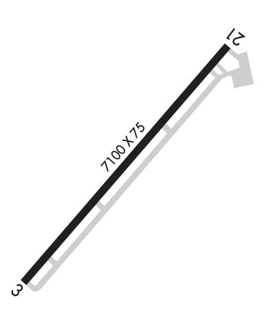
| Rwy | Rwy | |||||||
| 7360x100 | 7360' | 7360x100 | 7100' | |||||
| 2121x60 | 2121' | 2121x60 | 2121' | |||||
| Runway ID | Single Wheel | Double Wheel | Double Tandem Wheel | Dual Double Wheel |
| 03/21 | N/A | 85,000 | N/A | N/A |
| 15/33 | N/A | N/A | N/A | N/A |
| These numbers are Advisory and are not limits. The Airport Manager should have more accurate Weight Limits | ||||
 Airport Diagram might not be current. | |
| Facility Name: | CANYONLANDS RGNL |
| City Name: | MOAB |
| County: | GRAND |
| State abbrev: | UT |
| State Name: | UTAH |
| Ownership: | PUBLICLY OWNED |
| Use: | OPEN TO THE PUBLIC |
| Owner's Name: | GRAND COUNTY |
| Address: | 125 E. CENTER |
| MOAB, UT 84532 | |
| Owner's Phone: | (435) 259-1347 |
| Manager's Name: | STEVEN GLEASON |
| Address: | 110 W. AVIATION WAY |
| MOAB, UT 84532 | |
| Phone: | 435-259-4120 |
| FAA Region: | NORTHWEST MOUNTAIN |
| FAA Field Office: | DEN |
| Date | Sunrise | Sunset |
|---|---|---|
| 06/08/26 Monday | 5:54 | 20:42 |
| 06/09/26 Tuesday | 5:54 | 20:43 |
| 06/10/26 Wednesday | 5:54 | 20:43 |
| 06/11/26 Thursday | 5:54 | 20:44 |
| 06/12/26 Friday | 5:53 | 20:44 |
| 06/13/26 Saturday | 5:53 | 20:45 |
| 06/14/26 Sunday | 5:53 | 20:45 |
| 06/15/26 Monday | 5:53 | 20:46 |
| 06/16/26 Tuesday | 5:54 | 20:46 |
| 06/17/26 Wednesday | 5:54 | 20:46 |
| 06/18/26 Thursday | 5:54 | 20:47 |
| 06/19/26 Friday | 5:54 | 20:47 |
| 06/20/26 Saturday | 5:54 | 20:47 |
| 06/21/26 Sunday | 5:54 | 20:47 |
| Airport Attendance Schedule | MAR-OCT 7 Days A Week 0800-1800, NOV-FEB 7 Days A Week 0900-1700 |
| Airport Status | OPERATIONAL (This Status can change at any time - please check NOTAMS) |
| Airport Lighting Schedule | ACTVT REIL RWY 03 & 21; MIRL RWY 03/21 - CTAF. PAPI RWY 03 & 21 ON CONSLY DURG DALGT HRS; ACTVT SS-SR - CTAF. |
| Airport Storage Available | Tie Downs, Hanger |
| Extra Services Available | Charter, Flight Instruction, Aircraft Rental |
| Wind Indicator | YES - (lighted) |
| Control Tower | NO |
| CTAF Frequency | 122.800 |
| Unicom Frequency | 122.800 |
| Rotating Beacon Color | WG |
| Segmented Circle | YES |
| Landing Fee | YES |
| Airport Inspected | STATE - performed by FAA AIRPORTS FIELD PERSONNEL |
| Inspection Date | 05/23/2025 |
| Type of Fuel Available | Grade 100LL, JET A (freeze point -40C) |
| Airframe Repair Service | MINOR |
| Power Plant Repair Service | MINOR |
| Latitude | N3845.5 |
| Longitude | W10945.2 (ESTIMATED) |
| Arpt Elevation | 4579ft (SURVEYED) |
| Magnetic Variation | 10E |
| 15 miles NW | of MOAB |
| Traffic Pattern Altitude | |
| Sectional Chart | DENVER |
| Operations (Reported) | Yearly | Avg. Daily |
|---|---|---|
| General Aviation Transient | 0 | 0 |
| General Aviation Local | 0 | 0 |
| Air Taxi | 0 | 0 |
| Commerical | 0 | 0 |
| Commuter | 0 | 0 |
| Military | 0 | 0 |
| Aircraft based on Field | |
|---|---|
| General Aviation Singles | 0 |
| General Aviation Multi | 0 |
| Jet Aircraft | 0 |
| General Aviation Helicopters | 0 |
| Military Aircraft | 0 |
| Gliders | 0 |
| Ultralights | 0 |
| FSS on field | NO |
| FSS tie-in | CEDAR CITY |
| FSS Phone | 1-800-WX-BRIEF |
| Who issues Notams | CNY |
| Notam D service at airport | YES |
| ARTCC Name | DENVER |
| Airport Certification | AIRPORT RECEIVING SCHEDULED AIR CARRIER SERVICE FROM CARRIERS CERTIFICATED BY THE CIVIL AERONAUTICS BOARD |
| Aircraft Rescue & Firefighting Index | AIRPORT HAS A CERTIFICATE UNDER CFR PART 139 |
| Airport of Entry | No |
| Custom Landing Rights | No |
| Joint Civil/Military | No |
| Military Landing rights | YES |
| NATIONAL PLAN OF INTEGRATED AIRPORT SYSTEMS (NPIAS) |
| GRANT AGREEMENTS UNDER FAAP/ADAP/AIP |
| CONVEYANCE UNDER SCETION 16, FEDERAL AIRPORT ACT OF 1946 OR SECTION 23, AIRPORT AND AIRWAY DEVELOPMENT ACT OF 1970 |
| ASSURANCES PURSUANT TO TITLE VI, CIVIL RIGHTS ACT OF 1964 |
| RWY 15/3 3 RWY 15/33 NOT AVBL FOR PART 121/PART 380 OPS WITH SKED PAX CARRYING OPS MORE THAN 9 PAX SEATS AND NON-SKED PAX CARRYING OPS MORE THAN 30 PAX SEATS. |
| RWY 03/2 1 PCR VALUE: 327/F/D/X/T |
Airport Communications & Frequencies:
| |||||||||
| Runway: 03 | Runway: 21 | ||
| Mag heading: | 30° | Mag heading: | 210° |
| Rwy Slope: | .07% Up | Rwy Slope: | -.07% Down |
| Approach: | Approach: | ||
| Pattern: | Left Traffic | Pattern: | Right Traffic |
| Markings: | NONPRECISION INSTRUMENT | Markings: | NONPRECISION INSTRUMENT |
| Marking Condition: | GOOD | Marking Condition: | GOOD |
| Arresting Dev: | Arresting Dev: | ||
| Lat & Long: | N3844.8 W10945.8 | Lat. & Long.: | N3845.7 W10944.8 |
| Elev: | 4552.7 ft. MSL | Elev: | 4557.9 ft. MSL |
| TCH: | 41 ft. AGL | TCH: | 42 ft. AGL |
| Visual Glide Path: | 3.35 degrees | Visual Glide Path: | 3.00 degrees |
| Displaced Threshold: | No | Displaced Threshold: | 260 feet |
| Touchdown Zone: | YES | Touchdown Zone: | YES |
| Touchdown Elev.: | 4558.0 feet | Touchdown Elev.: | 4557.9 feet |
| Visual Glide Slope: | 4-Light PAPI on LEFT side of Runway | Visual Glide Slope: | 4-Light PAPI on LEFT side of Runway; PAPI DOES NOT PROVD OBST CLNC BYD 2.9 NM FM RWY THLD. |
| RVR Equipment: | RVR Equipment: | ||
| RVV Equipment: | NO | RVV Equipment: | NO |
| Approach Lights: | Approach Lights: | ||
| REIL: | YES | REIL: | YES |
| Centerline Lights: | NO | Centerline Lights: | NO |
| Touchdown lights: | NO | Touchdown lights: | NO |
| Runway Category: | Runway with a Non-precision Approach having visibility minimums greater than 3/4 mile | Runway Category: | Runway with a Non-precision Approach having visibility minimums greater than 3/4 mile |
| Declared Distances: | TORA:7101' TODA:7361' ASDA:7101' LDA:7101' | Declared Distances: | TORA:7361' TODA:7361' ASDA:7361' LDA:7101' |
| Obstructions: | Obstructions: | PLINE | |
| Marked: | Marked: | NOT Marked/Lighted | |
| Clearance slope: | 50:1 | Clearance slope: | 19:1 |
| Obstruction height: | Obstruction height: | 36 feet AGL | |
| Dist. from runway: | Dist. from runway: | 912 feet | |
| Centerline offset: | Centerline offset: | 464 feet left of centerline | |
| Comments: | Comments: |
| Runway: 15 | Runway: 33 | ||
| Mag heading: | 148° | Mag heading: | 328° |
| Rwy Slope: | -.74% Down | Rwy Slope: | .74% Up |
| Approach: | Approach: | ||
| Pattern: | Left Traffic | Pattern: | Left Traffic |
| Markings: | NONE | Markings: | NONE |
| Marking Condition: | POOR | Marking Condition: | POOR |
| Arresting Dev: | Arresting Dev: | ||
| Lat & Long: | N3846.2 W10944.9 | Lat. & Long.: | N3845.9 W10944.8 |
| Elev: | 4579.2 ft. MSL | Elev: | 4563.5 ft. MSL |
| TCH: | TCH: | ||
| Visual Glide Path: | Visual Glide Path: | ||
| Displaced Threshold: | No | Displaced Threshold: | No |
| Touchdown Zone: | YES | Touchdown Zone: | YES |
| Touchdown Elev.: | 4579.2 feet | Touchdown Elev.: | 4579.2 feet |
| Visual Glide Slope: | Visual Glide Slope: | ||
| RVR Equipment: | RVR Equipment: | ||
| RVV Equipment: | NO | RVV Equipment: | NO |
| Approach Lights: | Approach Lights: | ||
| REIL: | NO | REIL: | NO |
| Centerline Lights: | NO | Centerline Lights: | NO |
| Touchdown lights: | NO | Touchdown lights: | NO |
| Runway Category: | Runway with a Visual Approach | Runway Category: | Runway with a Visual Approach |
| Declared Distances: | TORA:2000' TODA:2000' ASDA:2000' LDA:2000' | Declared Distances: | TORA:2000' TODA:2000' ASDA:2000' LDA:2000' |
Thanks for using FltPlan.com
all rights reserved © 1999-2026 by Flight Plan LLC
