| CHINO CHINO CA |
| |
| Lat: N 3358.5 Long: W 11738.2 Elev: 650 Var: -14 Longest Runway: 7000 | ||
| Dept. ATIS: 125.85 Arr. ATIS: 125.85 AWOS: 127.07 Ground: 121.6 Tower: 118.5 | ||
| |||||||||||||||||||||||||||||||||||||||||||||||||||||||||||||||||||||
| |||||||||||||||||||||||||||||||||||||||||||||||||||||||||||||||||||||
| |||||||||||||||||||||||||||||||||||||||||||||||||||||||||||||||||||||
| |||||||||||||||||||||||||||||||||||||||||||||||||||||||||||||||||||||
| |||||||||||||||||||||||||||||||||||||||||||||||||||||||||||||||||||||
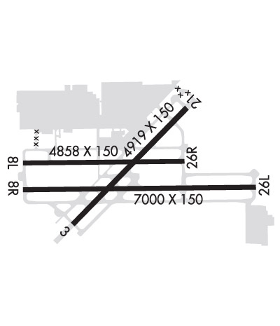
| Rwy | Rwy | |||||||
| 4919x150 | 4919' | 4919x150 | 4919' | |||||
| 4858x150 | 4858' | 4858x150 | 4858' | 111.50 - 255° | ||||
| 7000x150 | 7000' | 7000x150 | 7000' | |||||
| Runway ID | Single Wheel | Double Wheel | Double Tandem Wheel | Dual Double Wheel |
| 03/21 | 21,000 | 130,000 | N/A | 50,000 |
| 08L/26R | 12,000 | N/A | N/A | N/A |
| 08R/26L | 75,000 | 150,000 | 215,000 | N/A |
| These numbers are Advisory and are not limits. The Airport Manager should have more accurate Weight Limits | ||||
 Airport Diagram might not be current. | |
| Facility Name: | CHINO |
| City Name: | CHINO |
| County: | SAN BERNARDINO |
| State abbrev: | CA |
| State Name: | CALIFORNIA |
| Ownership: | PUBLICLY OWNED |
| Use: | OPEN TO THE PUBLIC |
| Owner's Name: | COUNTY OF SAN BERNARDINO |
| Address: | 268 W. HOSPITALITY LANE, SUITE 302 |
| CHINO, CA 91710-9091 | |
| Owner's Phone: | 909-387-8810 |
| Manager's Name: | GREGORY ZARCO |
| Address: | 7000 MERRILL AVE, BOX 1 |
| CHINO, CA 91710-0831 | |
| Phone: | 909-465-5202 |
| FAA Region: | WESTERN-PACIFIC |
| FAA Field Office: | LAX |
| Date | Sunrise | Sunset |
|---|---|---|
| 06/08/26 Monday | 5:39 | 20:00 |
| 06/09/26 Tuesday | 5:39 | 20:01 |
| 06/10/26 Wednesday | 5:39 | 20:01 |
| 06/11/26 Thursday | 5:39 | 20:02 |
| 06/12/26 Friday | 5:39 | 20:02 |
| 06/13/26 Saturday | 5:39 | 20:03 |
| 06/14/26 Sunday | 5:39 | 20:03 |
| 06/15/26 Monday | 5:39 | 20:03 |
| 06/16/26 Tuesday | 5:39 | 20:04 |
| 06/17/26 Wednesday | 5:39 | 20:04 |
| 06/18/26 Thursday | 5:39 | 20:04 |
| 06/19/26 Friday | 5:39 | 20:04 |
| 06/20/26 Saturday | 5:39 | 20:05 |
| 06/21/26 Sunday | 5:40 | 20:05 |
| Airport Attendance Schedule | CONTINUOUS |
| Airport Status | OPERATIONAL (This Status can change at any time - please check NOTAMS) |
| Airport Lighting Schedule | WHEN ATCT CLSD MIRL RY 03/21, HIRL RY 08L/26R, MIRL 08R/26L ARE TURNED ON. PAPI RYS 26R, 08R, 26L, 03, 21 AND REIL RYS 03 & 21 OPER CONTINUOUSLY. |
| Airport Storage Available | Tie Downs, Hanger |
| Extra Services Available | Air Freight, Air Ambulance, Avionics, Cargo Handling, Charter, Flight Instruction, Aircraft Rental, Aircraft Sales |
| Wind Indicator | YES - (lighted) |
| Control Tower | YES |
| CTAF Frequency | 118.500 |
| Unicom Frequency | 122.950 |
| Rotating Beacon Color | WG |
| Segmented Circle | NO |
| Landing Fee | NO |
| Airport Inspected | STATE - performed by STATE AERONAUTICAL PERSONNEL |
| Inspection Date | 04/24/2025 |
| Type of Fuel Available | Grade 100LL, JET A (freeze point -40C); -10SELF-SERVICE FUEL AVBL 24 HRS. |
| Airframe Repair Service | MAJOR |
| Power Plant Repair Service | MAJOR |
| Latitude | N3358.5 |
| Longitude | W11738.2 (ESTIMATED) |
| Arpt Elevation | 650ft (SURVEYED) |
| Magnetic Variation | 14E |
| 3 miles SE | of CHINO |
| Traffic Pattern Altitude | 750; TWIN ENGINE TPA 1350 FT AGL. |
| Sectional Chart | LOS ANGELES |
| Operations (Reported) | Yearly | Avg. Daily |
|---|---|---|
| General Aviation Transient | 0 | 0 |
| General Aviation Local | 0 | 0 |
| Air Taxi | 0 | 0 |
| Commerical | 0 | 0 |
| Commuter | 0 | 0 |
| Military | 0 | 0 |
| Aircraft based on Field | |
|---|---|
| General Aviation Singles | 0 |
| General Aviation Multi | 0 |
| Jet Aircraft | 0 |
| General Aviation Helicopters | 0 |
| Military Aircraft | 0 |
| Gliders | 0 |
| Ultralights | 0 |
| FSS on field | NO |
| FSS tie-in | RIVERSIDE |
| FSS Phone | 1-800-WX-BRIEF |
| Who issues Notams | CNO |
| Notam D service at airport | YES |
| ARTCC Name | LOS ANGELES |
| Airport Certification | |
| Aircraft Rescue & Firefighting Index | None |
| Airport of Entry | No |
| Custom Landing Rights | No |
| Joint Civil/Military | No |
| Military Landing rights | YES |
| NATIONAL PLAN OF INTEGRATED AIRPORT SYSTEMS (NPIAS) |
| GRANT AGREEMENTS UNDER FAAP/ADAP/AIP |
| SURPLUS PROPERTY AGREEMENT UNDER PUBLIC LAW 289 |
| ASSURANCES PURSUANT TO TITLE VI, CIVIL RIGHTS ACT OF 1964 |
| RADIO CONTROLLED AIRCRAFT ACTIVITY BELOW 400 FT AGL 2.5 NM SOUTH OF AIRPORT |
| BIRDS AND WILDLIFE ON AND INVOF ARPT. |
| FOR CD WHEN ATCT CLSD CTC SOCAL APCH AT 800-448-3724. |
Airport Communications & Frequencies:
| ||||||||||||||||||||||||||||||||||||||
| Runway: 03 | Runway: 21 | ||
| Mag heading: | 30° | Mag heading: | 210° |
| Rwy Slope: | .80% Up | Rwy Slope: | -.80% Down |
| Approach: | Approach: | ||
| Pattern: | Right Traffic | Pattern: | Left Traffic |
| Markings: | NONPRECISION INSTRUMENT | Markings: | NONPRECISION INSTRUMENT |
| Marking Condition: | GOOD | Marking Condition: | GOOD |
| Arresting Dev: | Arresting Dev: | ||
| Lat & Long: | N3358.2 W11738.5 | Lat. & Long.: | N3358.8 W11737.8 |
| Elev: | 610.4 ft. MSL | Elev: | 649.7 ft. MSL |
| TCH: | 40 ft. AGL | TCH: | 40 ft. AGL |
| Visual Glide Path: | 3.00 degrees | Visual Glide Path: | 3.00 degrees |
| Displaced Threshold: | No | Displaced Threshold: | No |
| Touchdown Zone: | YES | Touchdown Zone: | YES |
| Touchdown Elev.: | 635.0 feet | Touchdown Elev.: | 650.0 feet |
| Visual Glide Slope: | 4-Light PAPI on LEFT side of Runway | Visual Glide Slope: | 4-Light PAPI on LEFT side of Runway |
| RVR Equipment: | RVR Equipment: | ||
| RVV Equipment: | NO | RVV Equipment: | NO |
| Approach Lights: | Approach Lights: | ||
| REIL: | YES | REIL: | YES |
| Centerline Lights: | NO | Centerline Lights: | NO |
| Touchdown lights: | NO | Touchdown lights: | NO |
| Runway Category: | Runway with a Visual Approach | Runway Category: | Runway with a Visual Approach |
| Declared Distances: | Declared Distances: |
| Runway: 08L | Runway: 26R | ||
| Mag heading: | 75° | Mag heading: | 255° |
| Rwy Slope: | .39% Up | Rwy Slope: | -.39% Down |
| Approach: | Approach: | ILS | |
| Pattern: | Right Traffic | Pattern: | Left Traffic |
| Markings: | BASIC | Markings: | PRECISION INSTRUMENT |
| Marking Condition: | GOOD | Marking Condition: | GOOD |
| Arresting Dev: | Arresting Dev: | ||
| Lat & Long: | N3358.5 W11738.8 | Lat. & Long.: | N3358.6 W11737.8 |
| Elev: | 617.2 ft. MSL | Elev: | 636.1 ft. MSL |
| TCH: | 50 ft. AGL | TCH: | 53 ft. AGL |
| Visual Glide Path: | 3.00 degrees | Visual Glide Path: | 3.00 degrees |
| Displaced Threshold: | No | Displaced Threshold: | No |
| Touchdown Zone: | YES | Touchdown Zone: | YES |
| Touchdown Elev.: | 629.6 feet | Touchdown Elev.: | 636.1 feet |
| Visual Glide Slope: | 4-Light PAPI on LEFT side of Runway | Visual Glide Slope: | 4-Light PAPI on LEFT side of Runway |
| RVR Equipment: | RVR Equipment: | ||
| RVV Equipment: | NO | RVV Equipment: | NO |
| Approach Lights: | Approach Lights: | ||
| REIL: | NO | REIL: | NO |
| Centerline Lights: | NO | Centerline Lights: | NO |
| Touchdown lights: | NO | Touchdown lights: | NO |
| Runway Category: | Runway with a Visual Approach | Runway Category: | Precision Instrument Runway |
| Declared Distances: | Declared Distances: | ||
| Obstructions: | TREES | Obstructions: | TREES |
| Marked: | NOT Marked/Lighted | Marked: | NOT Marked/Lighted |
| Clearance slope: | 21:1 | Clearance slope: | 32:1 |
| Obstruction height: | 65 feet AGL | Obstruction height: | 60 feet AGL |
| Dist. from runway: | 1571 feet | Dist. from runway: | 2150 feet |
| Centerline offset: | 140 left of centerline | Centerline offset: | 250 feet left of centerline |
| Comments: | Comments: |
| Runway: 08R | Runway: 26L | ||
| Mag heading: | 75° | Mag heading: | 255° |
| Rwy Slope: | .24% Up | Rwy Slope: | -.24% Down |
| Approach: | Approach: | ||
| Pattern: | Right Traffic | Pattern: | Left Traffic |
| Markings: | NONPRECISION INSTRUMENT | Markings: | NONPRECISION INSTRUMENT |
| Marking Condition: | GOOD | Marking Condition: | GOOD |
| Arresting Dev: | Arresting Dev: | ||
| Lat & Long: | N3358.4 W11738.8 | Lat. & Long.: | N3358.4 W11737.4 |
| Elev: | 619.5 ft. MSL | Elev: | 636.5 ft. MSL |
| TCH: | 52 ft. AGL | TCH: | 55 ft. AGL |
| Visual Glide Path: | 3.00 degrees | Visual Glide Path: | 3.00 degrees |
| Displaced Threshold: | No | Displaced Threshold: | No |
| Touchdown Zone: | YES | Touchdown Zone: | YES |
| Touchdown Elev.: | 624.8 feet | Touchdown Elev.: | 636.5 feet |
| Visual Glide Slope: | 4-Light PAPI on LEFT side of Runway | Visual Glide Slope: | 4-Light PAPI on LEFT side of Runway |
| RVR Equipment: | RVR Equipment: | ||
| RVV Equipment: | NO | RVV Equipment: | NO |
| Approach Lights: | Approach Lights: | ||
| REIL: | NO | REIL: | NO |
| Centerline Lights: | NO | Centerline Lights: | NO |
| Touchdown lights: | NO | Touchdown lights: | NO |
| Runway Category: | Runway with a Visual Approach | Runway Category: | Runway with a Visual Approach |
| Declared Distances: | Declared Distances: | ||
| Obstructions: | Obstructions: | TREES | |
| Marked: | Marked: | NOT Marked/Lighted | |
| Clearance slope: | 50:1 | Clearance slope: | 20:1 |
| Obstruction height: | Obstruction height: | 55 feet AGL | |
| Dist. from runway: | Dist. from runway: | 1320 feet | |
| Centerline offset: | Centerline offset: | 75 feet left of centerline | |
| Comments: | Comments: |
Thanks for using FltPlan.com
all rights reserved © 1999-2026 by Flight Plan LLC