
| CAVERN CITY AIR TRML CARLSBAD NM |
| |
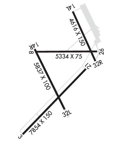
| Lat: N 3220.2 Long: W 10415.8 Elev: 3295 Var: -10 Longest Runway: 7854 | ||
| AWOS: 118.37 CTAF: 123.0 | ||
| ||||||||||||||||||||||||||||||||||||||||||||
| ||||||||||||||||||||||||||||||||||||||||||||
| ||||||||||||||||||||||||||||||||||||||||||||
| Rwy | Rwy | |||||||
| 7854x150 | 7854' | 111.90 - 034° | 7854x150 | 7854' | ||||
| 5334x75 | 5334' | 5334x75 | 5334' | |||||
| 4616x150 | 4616' | 4616x150 | 4001' | |||||
| 5837x100 | 5837' | 5837x100 | 5452' | |||||
| Runway ID | Single Wheel | Double Wheel | Double Tandem Wheel | Dual Double Wheel |
| 03/21 | 62,000 | 88,000 | 140,000 | N/A |
| 08/26 | 19,000 | N/A | N/A | N/A |
| 14L/32R | 8,000 | 12,500 | N/A | N/A |
| 14R/32L | 30,000 | 45,000 | N/A | N/A |
| These numbers are Advisory and are not limits. The Airport Manager should have more accurate Weight Limits | ||||
 Airport Diagram might not be current. | |
| Facility Name: | CAVERN CITY AIR TRML |
| City Name: | CARLSBAD |
| County: | EDDY |
| State abbrev: | NM |
| State Name: | NEW MEXICO |
| Ownership: | PUBLICLY OWNED |
| Use: | OPEN TO THE PUBLIC |
| Owner's Name: | CITY OF CARLSBAD |
| Address: | 101 NORTH HALAGUENO ST |
| CARLSBAD, NM 88220 | |
| Owner's Phone: | 575-887-1191 |
| Manager's Name: | SHERRI CHANDLER |
| Address: | 101 NORTH HALAGUENO ST |
| CARLSBAD, NM 88220 | |
| Phone: | 575-887-3060 |
| FAA Region: | SOUTHWEST |
| FAA Field Office: | LNM |
| Date | Sunrise | Sunset |
|---|---|---|
| 09/24/21 Friday | 6:46 | 18:51 |
| 09/25/21 Saturday | 6:47 | 18:50 |
| 09/26/21 Sunday | 6:48 | 18:49 |
| 09/27/21 Monday | 6:48 | 18:47 |
| 09/28/21 Tuesday | 6:49 | 18:46 |
| 09/29/21 Wednesday | 6:50 | 18:45 |
| 09/30/21 Thursday | 6:50 | 18:43 |
| 10/01/21 Friday | 6:51 | 18:42 |
| 10/02/21 Saturday | 6:52 | 18:41 |
| 10/03/21 Sunday | 6:52 | 18:39 |
| 10/04/21 Monday | 6:53 | 18:38 |
| 10/05/21 Tuesday | 6:54 | 18:37 |
| 10/06/21 Wednesday | 6:54 | 18:36 |
| 10/07/21 Thursday | 6:55 | 18:34 |
| Airport Attendance Schedule | MON-SUN 0500-1700 |
| Airport Status | OPERATIONAL (This Status can change at any time - please check NOTAMS) |
| Airport Lighting Schedule | TO INCR INTST AND ACTVT MALSR RWY 03; DUSK-DAWN, ACTVT MIRL RWY 03/21, 08/26, 14R/32L PRESET LOW INTST - CTAF. |
| Airport Storage Available | Tie Downs, Hanger |
| Extra Services Available | Air Freight, Air Ambulance |
| Wind Indicator | YES - (lighted) |
| Control Tower | NO |
| CTAF Frequency | 123.000 |
| Unicom Frequency | 123.000 |
| Rotating Beacon Color | CLEAR-GREEN (Light Land Airport) |
| Segmented Circle | YES |
| Landing Fee | NO |
| Airport Inspected | STATE - performed by FAA AIRPORTS FIELD PERSONNEL |
| Inspection Date | 01/05/2021 |
| Type of Fuel Available | Grade 100LL, JET A-1 (icing inhibitor, freeze point -50C); -10FOR FUEL AFT HRS, SAT AND SUN CALL 575-887-1500. |
| Airframe Repair Service | None |
| Power Plant Repair Service | None |
| Latitude | N3220.2 |
| Longitude | W10415.8 (ESTIMATED) |
| Arpt Elevation | 3294ft (SURVEYED) |
| Magnetic Variation | 10E |
| 5 miles SW | of CARLSBAD |
| Traffic Pattern Altitude | |
| Sectional Chart | ALBUQUERQUE |
| Operations (Reported) | Yearly | Avg. Daily |
|---|---|---|
| General Aviation Transient | 0 | 0 |
| General Aviation Local | 3175 | 9 |
| Air Taxi | 0 | 0 |
| Commerical | 5224 | 14 |
| Commuter | 0 | 0 |
| Military | 250 | 1 |
| Aircraft based on Field | |
|---|---|
| General Aviation Singles | 20 |
| General Aviation Multi | 1 |
| Jet Aircraft | 2 |
| General Aviation Helicopters | 3 |
| Military Aircraft | 0 |
| Gliders | 0 |
| Ultralights | 0 |
| FSS on field | NO |
| FSS tie-in | ALBUQUERQUE |
| FSS Phone | 1-800-WX-BRIEF |
| Who issues Notams | CNM |
| Notam D service at airport | YES |
| ARTCC Name | ALBUQUERQUE |
| Airport Certification | AIRPORT RECEIVING SCHEDULED AIR CARRIER SERVICE FROM CARRIERS CERTIFICATED BY THE CIVIL AERONAUTICS BOARD; 24 HRS PPR FOR ACR OPNS WITH MORE THAN 30 PSGR SEATS CTC AMGR 575-887-3060. RY 14L/32R NOT AVBL FOR ACR OPNS. |
| Aircraft Rescue & Firefighting Index | AIRPORT HAS A CERTIFICATE UNDER CFR PART 139 |
| Airport of Entry | No |
| Custom Landing Rights | No |
| Joint Civil/Military | No |
| Military Landing rights | YES |
| NATIONAL PLAN OF INTEGRATED AIRPORT SYSTEMS (NPIAS) |
| GRANT AGREEMENTS UNDER FAAP/ADAP/AIP |
| SURPLUS PROPERTY AGREEMENT UNDER PUBLIC LAW 289 |
| CONVEYANCE UNDER SCETION 16, FEDERAL AIRPORT ACT OF 1946 OR SECTION 23, AIRPORT AND AIRWAY DEVELOPMENT ACT OF 1970 |
| ASSURANCES PURSUANT TO TITLE VI, CIVIL RIGHTS ACT OF 1964 |
| OIL DERRICKS INVOF ARPT. |
| FOR CD IF UNA TO CTC ON FSS FREQ, CTC ALBUQUERQUE ARTCC AT 505-856-4561. |
Airport Communications & Frequencies:
| |||||||||
| Runway: 03 | Runway: 21 | ||
| Mag heading: | 34° | Mag heading: | 214° |
| Rwy Slope: | -.60% Down | Rwy Slope: | .60% Up |
| Approach: | ILS | Approach: | |
| Pattern: | Left Traffic | Pattern: | Left Traffic |
| Markings: | PRECISION INSTRUMENT | Markings: | NONPRECISION INSTRUMENT |
| Marking Condition: | POOR | Marking Condition: | POOR |
| Arresting Dev: | Arresting Dev: | ||
| Lat & Long: | N3219.4 W10416.5 | Lat. & Long.: | N3220.3 W10415.4 |
| Elev: | 3294.5 ft. MSL | Elev: | 3247.4 ft. MSL |
| TCH: | TCH: | 58 ft. AGL | |
| Visual Glide Path: | Visual Glide Path: | 3.00 degrees | |
| Displaced Threshold: | No | Displaced Threshold: | No |
| Touchdown Zone: | YES | Touchdown Zone: | YES |
| Touchdown Elev.: | 3294.6 feet | Touchdown Elev.: | 3264.2 feet |
| Visual Glide Slope: | Visual Glide Slope: | 4-BOX VASI ON LEFT SIDE OF RUNWAY | |
| RVR Equipment: | RVR Equipment: | ||
| RVV Equipment: | NO | RVV Equipment: | NO |
| Approach Lights: | MALSR - 1,400 foot medium intensity approach lighting system with runway alignment indicator lights | Approach Lights: | |
| REIL: | NO | REIL: | NO |
| Centerline Lights: | NO | Centerline Lights: | NO |
| Touchdown lights: | NO | Touchdown lights: | NO |
| Runway Category: | Precision Instrument Runway | Runway Category: | Runway with a Non-precision Approach having visibility minimums greater than 3/4 mile |
| Declared Distances: | TORA:7854' TODA:7854' ASDA:7854' LDA:7854' | Declared Distances: | TORA:7854' TODA:7854' ASDA:7854' LDA:7854' |
| Obstructions: | ROAD | Obstructions: | ROAD |
| Marked: | NOT Marked/Lighted | Marked: | NOT Marked/Lighted |
| Clearance slope: | 36:1 | Clearance slope: | 13:1 |
| Obstruction height: | 24 feet AGL | Obstruction height: | 14 feet AGL |
| Dist. from runway: | 1080 feet | Dist. from runway: | 388 feet |
| Centerline offset: | 623 left of centerline | Centerline offset: | 514 feet left of centerline |
| Comments: | Comments: |
| Runway: 08 | Runway: 26 | ||
| Mag heading: | 80° | Mag heading: | 260° |
| Rwy Slope: | -.58% Down | Rwy Slope: | .58% Up |
| Approach: | Approach: | ||
| Pattern: | Left Traffic | Pattern: | Left Traffic |
| Markings: | BASIC | Markings: | BASIC |
| Marking Condition: | GOOD | Marking Condition: | GOOD |
| Arresting Dev: | Arresting Dev: | ||
| Lat & Long: | N3220.5 W10416.2 | Lat. & Long.: | N3220.5 W10415.2 |
| Elev: | 3269.8 ft. MSL | Elev: | 3238.8 ft. MSL |
| TCH: | TCH: | ||
| Visual Glide Path: | Visual Glide Path: | ||
| Displaced Threshold: | No | Displaced Threshold: | No |
| Touchdown Zone: | YES | Touchdown Zone: | YES |
| Touchdown Elev.: | 3269.8 feet | Touchdown Elev.: | 3255.1 feet |
| Visual Glide Slope: | Visual Glide Slope: | ||
| RVR Equipment: | RVR Equipment: | ||
| RVV Equipment: | NO | RVV Equipment: | NO |
| Approach Lights: | Approach Lights: | ||
| REIL: | NO | REIL: | NO |
| Centerline Lights: | NO | Centerline Lights: | NO |
| Touchdown lights: | NO | Touchdown lights: | NO |
| Runway Category: | Runway with a Visual Approach | Runway Category: | Runway with a Visual Approach |
| Declared Distances: | TORA:5334' TODA:5334' ASDA:5334' LDA:5334' | Declared Distances: | TORA:5334' TODA:5334' ASDA:5334' LDA:5334' |
| Obstructions: | ROAD | Obstructions: | FENCE |
| Marked: | NOT Marked/Lighted | Marked: | NOT Marked/Lighted |
| Clearance slope: | 7:1 | Clearance slope: | |
| Obstruction height: | 15 feet AGL | Obstruction height: | 4 feet AGL |
| Dist. from runway: | 310 feet | Dist. from runway: | 200 feet |
| Centerline offset: | Centerline offset: | 125 feet right of centerline | |
| Comments: | Comments: |
| Runway: 14L | Runway: 32R | ||
| Mag heading: | 146° | Mag heading: | 326° |
| Rwy Slope: | .02% Up | Rwy Slope: | -.02% Down |
| Approach: | Approach: | ||
| Pattern: | Left Traffic | Pattern: | Right Traffic |
| Markings: | BASIC | Markings: | BASIC |
| Marking Condition: | GOOD | Marking Condition: | GOOD |
| Arresting Dev: | Arresting Dev: | ||
| Lat & Long: | N3221.1 W10415.6 | Lat. & Long.: | N3220.4 W10415.2 |
| Elev: | 3240.6 ft. MSL | Elev: | 3241.3 ft. MSL |
| TCH: | TCH: | ||
| Visual Glide Path: | Visual Glide Path: | ||
| Displaced Threshold: | No | Displaced Threshold: | 615 feet |
| Touchdown Zone: | YES | Touchdown Zone: | YES |
| Touchdown Elev.: | 3242.4 feet | Touchdown Elev.: | 3242.5 feet |
| Visual Glide Slope: | Visual Glide Slope: | ||
| RVR Equipment: | RVR Equipment: | ||
| RVV Equipment: | NO | RVV Equipment: | NO |
| Approach Lights: | Approach Lights: | ||
| REIL: | NO | REIL: | NO |
| Centerline Lights: | NO | Centerline Lights: | NO |
| Touchdown lights: | NO | Touchdown lights: | NO |
| Runway Category: | Runway with a Visual Approach | Runway Category: | Runway with a Visual Approach |
| Declared Distances: | TORA:4615' TODA:4615' ASDA:4615' LDA:4615' | Declared Distances: | TORA:4615' TODA:4615' ASDA:4615' LDA:3999' |
| Obstructions: | Obstructions: | ROAD | |
| Marked: | Marked: | NOT Marked/Lighted | |
| Clearance slope: | 50:1 | Clearance slope: | APCH RATIO 38:1 FM DSPLCD THLD. |
| Obstruction height: | Obstruction height: | 15 feet AGL | |
| Dist. from runway: | Dist. from runway: | 230 feet | |
| Centerline offset: | Centerline offset: | 150 feet right of centerline | |
| Comments: | Comments: |
| Runway: 14R | Runway: 32L | ||
| Mag heading: | 144° | Mag heading: | 324° |
| Rwy Slope: | -.04% Down | Rwy Slope: | .04% Up |
| Approach: | Approach: | ||
| Pattern: | Right Traffic | Pattern: | Left Traffic |
| Markings: | NONPRECISION INSTRUMENT | Markings: | NONPRECISION INSTRUMENT |
| Marking Condition: | GOOD | Marking Condition: | GOOD |
| Arresting Dev: | Arresting Dev: | ||
| Lat & Long: | N3220.6 W10416.3 | Lat. & Long.: | N3219.7 W10415.8 |
| Elev: | 3269.3 ft. MSL | Elev: | 3266.8 ft. MSL |
| TCH: | 56 ft. AGL | TCH: | 59 ft. AGL |
| Visual Glide Path: | 3.00 degrees | Visual Glide Path: | 3.00 degrees |
| Displaced Threshold: | No | Displaced Threshold: | 385 feet |
| Touchdown Zone: | YES | Touchdown Zone: | YES |
| Touchdown Elev.: | 3269.5 feet | Touchdown Elev.: | 3268.2 feet |
| Visual Glide Slope: | 4-Light PAPI on LEFT side of Runway | Visual Glide Slope: | 4-Light PAPI on LEFT side of Runway |
| RVR Equipment: | RVR Equipment: | ||
| RVV Equipment: | NO | RVV Equipment: | NO |
| Approach Lights: | Approach Lights: | ||
| REIL: | NO | REIL: | NO |
| Centerline Lights: | NO | Centerline Lights: | NO |
| Touchdown lights: | NO | Touchdown lights: | NO |
| Runway Category: | Runway with a Non-precision Approach having visibility minimums greater than 3/4 mile | Runway Category: | Runway with a Non-precision Approach having visibility minimums greater than 3/4 mile |
| Declared Distances: | TORA:5837' TODA:5837' ASDA:5837' LDA:5837' | Declared Distances: | TORA:5837' TODA:5837' ASDA:5837' LDA:5452' |
| Obstructions: | ROAD | Obstructions: | ROAD |
| Marked: | NOT Marked/Lighted | Marked: | NOT Marked/Lighted |
| Clearance slope: | 14:1 | Clearance slope: | 31:1; APCH SLOPE 50:1 FM DSPLCD THLD. |
| Obstruction height: | 7 feet AGL | Obstruction height: | 15 feet AGL |
| Dist. from runway: | 300 feet | Dist. from runway: | 672 feet |
| Centerline offset: | 150 left of centerline | Centerline offset: | 318 feet right of centerline |
| Comments: | Comments: |
Thanks for using FltPlan.com
all rights reserved © 1999-2021 by Flight Plan LLC
