
| BLOSSER MUNI CONCORDIA KS |
| |
| Lat: N 3933.0 Long: W 09739.1 Elev: 1488 Var: -06 Longest Runway: 4000 | ||
| AWOS: 123.82 CTAF: 122.8 | ||
| ||||||||||||||||||||||||||||||||||||||||||||
| ||||||||||||||||||||||||||||||||||||||||||||
| ||||||||||||||||||||||||||||||||||||||||||||
| Rwy | Rwy | |||||||
| 2040x60 | 2040' | 2040x60 | 2040' | |||||
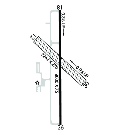
| 4000x75 | 4000' | 4000x75 | 4000' | |||||
| Runway ID | Single Wheel | Double Wheel | Double Tandem Wheel | Dual Double Wheel |
| 12/30 | N/A | N/A | N/A | N/A |
| 18/36 | 8,000 | 10,000 | N/A | N/A |
| These numbers are Advisory and are not limits. The Airport Manager should have more accurate Weight Limits | ||||
 Airport Diagram might not be current. | |
| Facility Name: | BLOSSER MUNI |
| City Name: | CONCORDIA |
| County: | CLOUD |
| State abbrev: | KS |
| State Name: | KANSAS |
| Ownership: | PUBLICLY OWNED |
| Use: | OPEN TO THE PUBLIC |
| Owner's Name: | CITY OF CONCORDIA |
| Address: | BOX 603 (CITY OFFICE) |
| CONCORDIA, KS 66901 | |
| Owner's Phone: | |
| Manager's Name: | FULLER BATES |
| Address: | 701 WASHINGTON |
| CONCORDIA, KS 66901 | |
| Phone: | 785-243-2670 |
| FAA Region: | CENTRAL |
| FAA Field Office: | NONE |
| Date | Sunrise | Sunset |
|---|---|---|
| 06/08/26 Monday | 6:03 | 20:56 |
| 06/09/26 Tuesday | 6:03 | 20:57 |
| 06/10/26 Wednesday | 6:03 | 20:57 |
| 06/11/26 Thursday | 6:03 | 20:58 |
| 06/12/26 Friday | 6:03 | 20:58 |
| 06/13/26 Saturday | 6:03 | 20:59 |
| 06/14/26 Sunday | 6:03 | 20:59 |
| 06/15/26 Monday | 6:03 | 21:00 |
| 06/16/26 Tuesday | 6:03 | 21:00 |
| 06/17/26 Wednesday | 6:03 | 21:00 |
| 06/18/26 Thursday | 6:03 | 21:01 |
| 06/19/26 Friday | 6:03 | 21:01 |
| 06/20/26 Saturday | 6:03 | 21:01 |
| 06/21/26 Sunday | 6:03 | 21:01 |
| Airport Attendance Schedule | MON-FRI 0800-1600 |
| Airport Status | OPERATIONAL (This Status can change at any time - please check NOTAMS) |
| Airport Lighting Schedule | ACTVT REIL RWY 18 & 36; PAPI RWY 18 & 36 - CTAF. MIRL RWY 18/36 PRESET MED INTST DUSK-2200; AFT 2200 ACTVT - CTAF. |
| Airport Storage Available | Tie Downs, Hanger |
| Extra Services Available | Crop Dusting |
| Wind Indicator | YES - (unlit) |
| Control Tower | NO |
| CTAF Frequency | 122.800 |
| Unicom Frequency | 122.800 |
| Rotating Beacon Color | WG |
| Segmented Circle | YES |
| Landing Fee | NO |
| Airport Inspected | STATE - performed by STATE AERONAUTICAL PERSONNEL |
| Inspection Date | 09/15/2023 |
| Type of Fuel Available | Grade 100LL, JET A |
| Airframe Repair Service | None |
| Power Plant Repair Service | None |
| Latitude | N3933.0 |
| Longitude | W09739.1 (ESTIMATED) |
| Arpt Elevation | 1488ft (SURVEYED) |
| Magnetic Variation | 06E |
| 2 miles S | of CONCORDIA |
| Traffic Pattern Altitude | |
| Sectional Chart | WICHITA |
| Operations (Reported) | Yearly | Avg. Daily |
|---|---|---|
| General Aviation Transient | 0 | 0 |
| General Aviation Local | 0 | 0 |
| Air Taxi | 0 | 0 |
| Commerical | 0 | 0 |
| Commuter | 0 | 0 |
| Military | 0 | 0 |
| Aircraft based on Field | |
|---|---|
| General Aviation Singles | 0 |
| General Aviation Multi | 0 |
| Jet Aircraft | 0 |
| General Aviation Helicopters | 0 |
| Military Aircraft | 0 |
| Gliders | 0 |
| Ultralights | 0 |
| FSS on field | NO |
| FSS tie-in | WICHITA |
| FSS Phone | 1-800-WX-BRIEF |
| Who issues Notams | CNK |
| Notam D service at airport | YES |
| ARTCC Name | KANSAS CITY |
| Airport Certification | |
| Aircraft Rescue & Firefighting Index | None |
| Airport of Entry | No |
| Custom Landing Rights | No |
| Joint Civil/Military | No |
| Military Landing rights | YES |
| NATIONAL PLAN OF INTEGRATED AIRPORT SYSTEMS (NPIAS) |
| GRANT AGREEMENTS UNDER FAAP/ADAP/AIP |
| ASSURANCES PURSUANT TO TITLE VI, CIVIL RIGHTS ACT OF 1964 |
| RDO CTL MODEL AIRPLANE TO 400 FT EAST; EVENING, WKEND & HOL. |
| FOR CD CTC KANSAS CITY ARTCC AT 913-254-8508. |
| FUEL AVBL H24 WITH CREDIT CARD. |
Airport Communications & Frequencies:
| |||||||||
| Runway: 12 | Runway: 30 | ||
| Mag heading: | 126° | Mag heading: | 306° |
| Rwy Slope: | -.71% Down | Rwy Slope: | .71% Up |
| Approach: | Approach: | ||
| Pattern: | Left Traffic | Pattern: | Left Traffic |
| Markings: | NONE | Markings: | NONE |
| Marking Condition: | Marking Condition: | ||
| Arresting Dev: | Arresting Dev: | ||
| Lat & Long: | N3933.1 W09739.3 | Lat. & Long.: | N3932.9 W09739.0 |
| Elev: | 1470.8 ft. MSL | Elev: | 1456.3 ft. MSL |
| TCH: | TCH: | ||
| Visual Glide Path: | Visual Glide Path: | ||
| Displaced Threshold: | No | Displaced Threshold: | No |
| Touchdown Zone: | YES | Touchdown Zone: | YES |
| Touchdown Elev.: | 1470.8 feet | Touchdown Elev.: | 1470.8 feet |
| Visual Glide Slope: | Visual Glide Slope: | ||
| RVR Equipment: | RVR Equipment: | ||
| RVV Equipment: | NO | RVV Equipment: | NO |
| Approach Lights: | Approach Lights: | ||
| REIL: | NO | REIL: | NO |
| Centerline Lights: | NO | Centerline Lights: | NO |
| Touchdown lights: | NO | Touchdown lights: | NO |
| Runway Category: | Runway with a Visual Approach | Runway Category: | Runway with a Visual Approach |
| Declared Distances: | Declared Distances: | ||
| Obstructions: | POLE | Obstructions: | FENCE |
| Marked: | MARKED | Marked: | MARKED |
| Clearance slope: | 5:1; CTLG OBSTN EXCEEDS 45 DEG SLP. | Clearance slope: | |
| Obstruction height: | 35 feet AGL | Obstruction height: | 15 feet AGL |
| Dist. from runway: | 176 feet | Dist. from runway: | 0 feet |
| Centerline offset: | Centerline offset: | 50 feet right of centerline | |
| Comments: | Comments: |
| Runway: 18 | Runway: 36 | ||
| Mag heading: | 174° | Mag heading: | 354° |
| Rwy Slope: | .31% Up | Rwy Slope: | -.31% Down |
| Approach: | Approach: | ||
| Pattern: | Left Traffic | Pattern: | Left Traffic |
| Markings: | NONPRECISION INSTRUMENT | Markings: | NONPRECISION INSTRUMENT |
| Marking Condition: | GOOD | Marking Condition: | GOOD |
| Arresting Dev: | Arresting Dev: | ||
| Lat & Long: | N3933.3 W09739.1 | Lat. & Long.: | N3932.7 W09739.1 |
| Elev: | 1475.6 ft. MSL | Elev: | 1488.1 ft. MSL |
| TCH: | 35 ft. AGL | TCH: | 40 ft. AGL |
| Visual Glide Path: | 3.00 degrees | Visual Glide Path: | 3.00 degrees |
| Displaced Threshold: | No | Displaced Threshold: | No |
| Touchdown Zone: | YES | Touchdown Zone: | YES |
| Touchdown Elev.: | 1475.6 feet | Touchdown Elev.: | 1488.1 feet |
| Visual Glide Slope: | 4-Light PAPI on LEFT side of Runway; PAPI UNUSBL BYD 4 DEGS LEFT OF CNTRLN. | Visual Glide Slope: | 4-Light PAPI on LEFT side of Runway; PAPI UNUSBL BYD 6 DEGS LEFT OF CNTRLN. |
| RVR Equipment: | RVR Equipment: | ||
| RVV Equipment: | NO | RVV Equipment: | NO |
| Approach Lights: | Approach Lights: | ||
| REIL: | YES | REIL: | YES |
| Centerline Lights: | NO | Centerline Lights: | NO |
| Touchdown lights: | NO | Touchdown lights: | NO |
| Runway Category: | Runway with a Non-precision Approach | Runway Category: | Runway with a Non-precision Approach |
| Declared Distances: | Declared Distances: |
Thanks for using FltPlan.com
all rights reserved © 1999-2026 by Flight Plan LLC
