
| SPARTA/FORT MC COY SPARTA WI |
| |
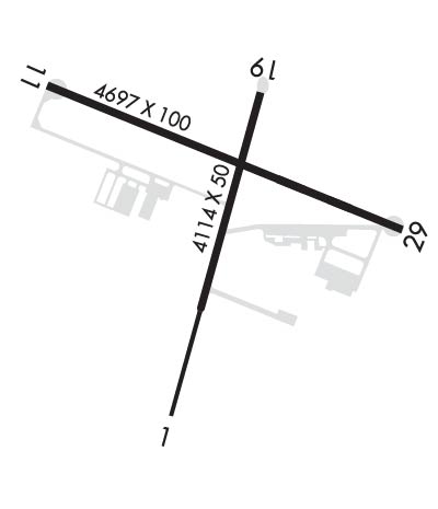
| Lat: N 4357.5 Long: W 09044.3 Elev: 839 Var: -00 Longest Runway: 4697 | ||
| AWOS: 118.37 Ground: 123.62 Tower: 124.6 | ||
| ||||||
| ||||||
|
| Rwy | Rwy | |||||||
| 3032x95 | 3032' | 3032x95 | 3032' | |||||
| 4697x100 | 4697' | 4697x100 | 4266' | |||||
| Runway ID | Single Wheel | Double Wheel | Double Tandem Wheel | Dual Double Wheel |
| 01/19 | N/A | N/A | N/A | N/A |
| 11/29 | N/A | N/A | N/A | N/A |
| These numbers are Advisory and are not limits. The Airport Manager should have more accurate Weight Limits | ||||
 Airport Diagram might not be current. | |
| Facility Name: | SPARTA/FORT MC COY |
| City Name: | SPARTA |
| County: | MONROE |
| State abbrev: | WI |
| State Name: | WISCONSIN |
| Ownership: | ARMY OWNED |
| Use: | OPEN TO THE PUBLIC |
| Owner's Name: | US ARMY |
| Address: | COMMANDER |
| FORT MC COY, WI 54656 | |
| Owner's Phone: | 502-898-4207 |
| Manager's Name: | JAMES HUBBARD; CIVIL AMGR MARK VAN WORMER - 608-269-4340 EX: 9-5157. |
| Address: | ATTN: AMIM-MCO-A |
| FORT MC COY, WI 54656 | |
| Phone: | 502-898-4107 |
| FAA Region: | GREAT LAKES |
| FAA Field Office: | CHI |
| Date | Sunrise | Sunset |
|---|---|---|
| 06/08/26 Monday | 5:21 | 20:44 |
| 06/09/26 Tuesday | 5:20 | 20:44 |
| 06/10/26 Wednesday | 5:20 | 20:45 |
| 06/11/26 Thursday | 5:20 | 20:45 |
| 06/12/26 Friday | 5:20 | 20:46 |
| 06/13/26 Saturday | 5:20 | 20:46 |
| 06/14/26 Sunday | 5:20 | 20:47 |
| 06/15/26 Monday | 5:20 | 20:47 |
| 06/16/26 Tuesday | 5:20 | 20:48 |
| 06/17/26 Wednesday | 5:20 | 20:48 |
| 06/18/26 Thursday | 5:20 | 20:48 |
| 06/19/26 Friday | 5:20 | 20:49 |
| 06/20/26 Saturday | 5:20 | 20:49 |
| 06/21/26 Sunday | 5:20 | 20:49 |
| Airport Attendance Schedule | MON-FRI 1400-2200Z++; EXC FED HOL. |
| Airport Status | OPERATIONAL (This Status can change at any time - please check NOTAMS) |
| Airport Lighting Schedule | WHEN TWR CLSD ACTVT REIL RWY 11 & 29; MIRL RWY 01/19 - CTAF. MIRL RWY 11/29 PRESET TO LOW SS-SR; INCR INTST CTAF. VGSI RWY 01, 11, 19 & 29 OPR CONSLY. |
| Airport Storage Available | Tie Downs |
| Extra Services Available | Flight Instruction |
| Wind Indicator | YES - (lighted) |
| Control Tower | YES |
| CTAF Frequency | 124.600 |
| Unicom Frequency | |
| Rotating Beacon Color | WG |
| Segmented Circle | NO |
| Landing Fee |
| Airport Inspected | STATE - performed by STATE AERONAUTICAL PERSONNEL |
| Inspection Date | 07/09/2025 |
| Type of Fuel Available | Grade 100LLA++; -10CREDIT CARD SELF SVC H24 ON CIVIL RAMP.; -A+MIL RAMP SELF SVC H24 1 APR - 30 SEP & MON-FRI 1 OCT - 31 MAR TO TRAINED AIRCREW ONLY. 1 OCT - 31 MAR PPR BY THURS 2200Z++ FOR WKEND FUEL OR SVC; C502-898-4107. |
| Airframe Repair Service | None |
| Power Plant Repair Service | None |
| Latitude | N4357.5 |
| Longitude | W09044.3 (ESTIMATED) |
| Arpt Elevation | 839ft (ESTIMATED) |
| Magnetic Variation | 00E |
| 3 miles NE | of SPARTA |
| Traffic Pattern Altitude | |
| Sectional Chart | CHICAGO |
| Operations (Reported) | Yearly | Avg. Daily |
|---|---|---|
| General Aviation Transient | 0 | 0 |
| General Aviation Local | 0 | 0 |
| Air Taxi | 0 | 0 |
| Commerical | 0 | 0 |
| Commuter | 0 | 0 |
| Military | 0 | 0 |
| Aircraft based on Field | |
|---|---|
| General Aviation Singles | 0 |
| General Aviation Multi | 0 |
| Jet Aircraft | 0 |
| General Aviation Helicopters | 0 |
| Military Aircraft | 0 |
| Gliders | 0 |
| Ultralights | 0 |
| FSS on field | NO |
| FSS tie-in | GREEN BAY |
| FSS Phone | 1-800-WX-BRIEF |
| Who issues Notams | CMY |
| Notam D service at airport | YES |
| ARTCC Name | CHICAGO |
| Airport Certification | |
| Aircraft Rescue & Firefighting Index | RSTD: ARFF SVC AVBL WITH 72 HR NOTICE - C502-898-2508/3553; INDEX B SVC AVBL H24. |
| Airport of Entry | No |
| Custom Landing Rights | No |
| Joint Civil/Military | YES |
| Military Landing rights | No |
| NATIONAL PLAN OF INTEGRATED AIRPORT SYSTEMS (NPIAS) |
| RWY 01, 11, 29 NSTD SAFETY AREA BYD EACH END DUE TO TRRN & FENCE. |
| PAJA 3.5 NM E - NE YEAR ROUND. |
| RSTD: ARFF SVC AVBL WITH 72 HR NOTICE - C502-898-2508/3553; INDEX B SVC AVBL H24. |
| FOR CD WHEN ATCT CLSD CTC CHICAGO ARTCC AT 630-906-8921. |
| BIRDS & WILDLIFE ON & INVOF ARPT. |
| 24 HR PPR FOR SVC AFT 2200Z++ - C502-898-4107. CLSD FED HOL & BY NOTAM. FUEL & T RQMNTS - AP/1. |
| FICON UNMNT AFT HR. |
| SNOW REMOVAL OPS MNT CTAF WHEN ATCT CLSD. |
| LGTD WINDCONE RWY 01 & 11. |
| RAPIDLY RISING TRRN 1 NM NW - NE. |
| C130 & LRGR 180 DEG TURNS PMTD ON CONC SFC RWY 11/29 E & W ENDS & RWY 01/19 S END. |
| R6901B 500 YDS DEP END RWY 11. |
| RWY 11/2 9 HVY ASSAULT STRIP OPS E. NSTD N LATERAL CLNC; SEE KCMY AP/1 FOR INFO. |
| RWY 11 CTN: DEP; VEHICLES ON ROAD MAY APPEAR TO BE ON RWY. |
| RWY 19 CTLD SMALL ARMS RANGE 1000 YDS DEP END. |
Airport Communications & Frequencies:
| |||||||||||||||||||||||||
| Runway: 01 | Runway: 19 | ||
| Mag heading: | 15° | Mag heading: | 195° |
| Rwy Slope: | -.43% Down | Rwy Slope: | .43% Up |
| Approach: | Approach: | ||
| Pattern: | Left Traffic | Pattern: | Left Traffic |
| Markings: | NONPRECISION INSTRUMENT | Markings: | NONPRECISION INSTRUMENT |
| Marking Condition: | GOOD | Marking Condition: | GOOD |
| Arresting Dev: | Arresting Dev: | ||
| Lat & Long: | N4357.2 W09044.4 | Lat. & Long.: | N4357.7 W09044.2 |
| Elev: | 839.4 ft. MSL | Elev: | 826.5 ft. MSL |
| TCH: | 45 ft. AGL | TCH: | 45 ft. AGL |
| Visual Glide Path: | 3.50 degrees | Visual Glide Path: | 3.50 degrees |
| Displaced Threshold: | No | Displaced Threshold: | No |
| Touchdown Zone: | YES | Touchdown Zone: | YES |
| Touchdown Elev.: | 839.4 feet | Touchdown Elev.: | 839.2 feet |
| Visual Glide Slope: | 2-Light PAPI on LEFT side of Runway | Visual Glide Slope: | 2-Light PAPI on LEFT side of Runway |
| RVR Equipment: | RVR Equipment: | ||
| RVV Equipment: | NO | RVV Equipment: | NO |
| Approach Lights: | Approach Lights: | ||
| REIL: | NO | REIL: | NO |
| Centerline Lights: | NO | Centerline Lights: | NO |
| Touchdown lights: | NO | Touchdown lights: | NO |
| Runway Category: | Runway with a Visual Approach | Runway Category: | Runway with a Visual Approach |
| Declared Distances: | Declared Distances: |
| Runway: 11 | Runway: 29 | ||
| Mag heading: | 112° | Mag heading: | 292° |
| Rwy Slope: | .21% Up | Rwy Slope: | -.21% Down |
| Approach: | Approach: | ||
| Pattern: | Left Traffic | Pattern: | Left Traffic |
| Markings: | NONPRECISION INSTRUMENT | Markings: | NONPRECISION INSTRUMENT |
| Marking Condition: | GOOD | Marking Condition: | GOOD |
| Arresting Dev: | Arresting Dev: | ||
| Lat & Long: | N4357.7 W09044.8 | Lat. & Long.: | N4357.4 W09043.8 |
| Elev: | 821.8 ft. MSL | Elev: | 831.6 ft. MSL |
| TCH: | 42 ft. AGL | TCH: | 43 ft. AGL |
| Visual Glide Path: | 3.00 degrees | Visual Glide Path: | 3.00 degrees |
| Displaced Threshold: | No | Displaced Threshold: | 431 feet |
| Touchdown Zone: | YES | Touchdown Zone: | YES |
| Touchdown Elev.: | 828.5 feet | Touchdown Elev.: | 831.2 feet |
| Visual Glide Slope: | 4-Light PAPI on LEFT side of Runway | Visual Glide Slope: | 4-Light PAPI on LEFT side of Runway |
| RVR Equipment: | RVR Equipment: | ||
| RVV Equipment: | NO | RVV Equipment: | NO |
| Approach Lights: | Approach Lights: | ||
| REIL: | YES | REIL: | YES |
| Centerline Lights: | NO | Centerline Lights: | NO |
| Touchdown lights: | NO | Touchdown lights: | NO |
| Runway Category: | Runway with a Non-precision Approach having visibility minimums greater than 3/4 mile | Runway Category: | Runway with a Non-precision Approach having visibility minimums greater than 3/4 mile |
| Declared Distances: | Declared Distances: | ||
| Obstructions: | TREES | Obstructions: | ROAD |
| Marked: | NOT Marked/Lighted | Marked: | MARKED and LIGHTED |
| Clearance slope: | 20:1 | Clearance slope: | APCH RATIO 34:1 TO DTHR. |
| Obstruction height: | 55 feet AGL | Obstruction height: | 15 feet AGL |
| Dist. from runway: | 1315 feet | Dist. from runway: | 200 feet |
| Centerline offset: | 210 right of centerline | Centerline offset: | 10 feet left of centerline |
| Comments: | Comments: | 15 FT ROAD 0-200 FT FM RWY END 0-107 FT L. |
Thanks for using FltPlan.com
all rights reserved © 1999-2026 by Flight Plan LLC
